Cited by 11

The DOI matches its Crossref record.

Applying geomorphological principles and engineering science to develop a phased Sediment Management Plan for Mount St Helens, Washington

Sclafani, Paul, Nygaard, Chris, Thorne, Colin·2018·Earth Surface Processes and Landforms

Abstract

Thirty‐seven years post‐eruption, erosion of the debris avalanche at Mount St Helens continues to supply sediment to the Toutle–Cowlitz River system in quantities that have the potential to lower the Level of Protection (LoP) against flooding unacceptably, making this one of the most protracted gravel‐bed river disasters to date. The Portland District, US Army Corps of Engineers (USACE) recently revised its long‐term plan for sediment management (originally published in 1985), in order to maintain the LoP above the Congressionally‐authorized level, while reducing impacts on fish currently listed under the Endangered Species Act, and minimizing the overall cost of managing sediment derived from erosion at Mount St Helens. In revising the plan, the USACE drew on evidence gained from sediment monitoring, modelling and uncertainty analysis, coupled with assessment of future LoP trends under a baseline scenario (continuation of the 1985 sediment management strategy) and feasible alternatives. They applied geomorphological principles and used engineering science to develop a phased Sediment Management Plan that allows for uncertainty concerning future sediment yields by implementing sediment management actions only as, and when, necessary. The phased plan makes best use of the potential to enhance the sediment trap efficiency and storage capacity of the existing Sediment Retention Structure (SRS) by incrementally raising its spillway and using novel hydraulic structures to build islands in the North Fork Toutle River (NFTR) and steepen the gradient of the sediment plain upstream of the structure. Dredging is held in reserve, to be performed only when necessary to react to unexpectedly high sedimentation events or when the utility of other measures has been expended. The engineering‐geomorphic principles and many of the measures in the phased Sediment Management Plan are transferrable to other gravel‐bed river disasters. The overriding message is that monitoring and adaptive management are crucial components of long‐term sediment‐disaster management, especially in volcanic landscapes where future sediment yields are characterized by uncertainty and natural variability. © 2017 The Authors. Earth Surface Processes and Landforms published by John Wiley & Sons Ltd.

Overview

The claims and statistics of this paper haven’t been checked yet.

Run the check — free, no account needed. It reads the open-access text and checks the sources it cites.

A few free checks a day · papers already verified open instantly · results are public

Integrity signals

Registry

Crossref · 10.1002/esp.4277

Cites

Statistics

Figures

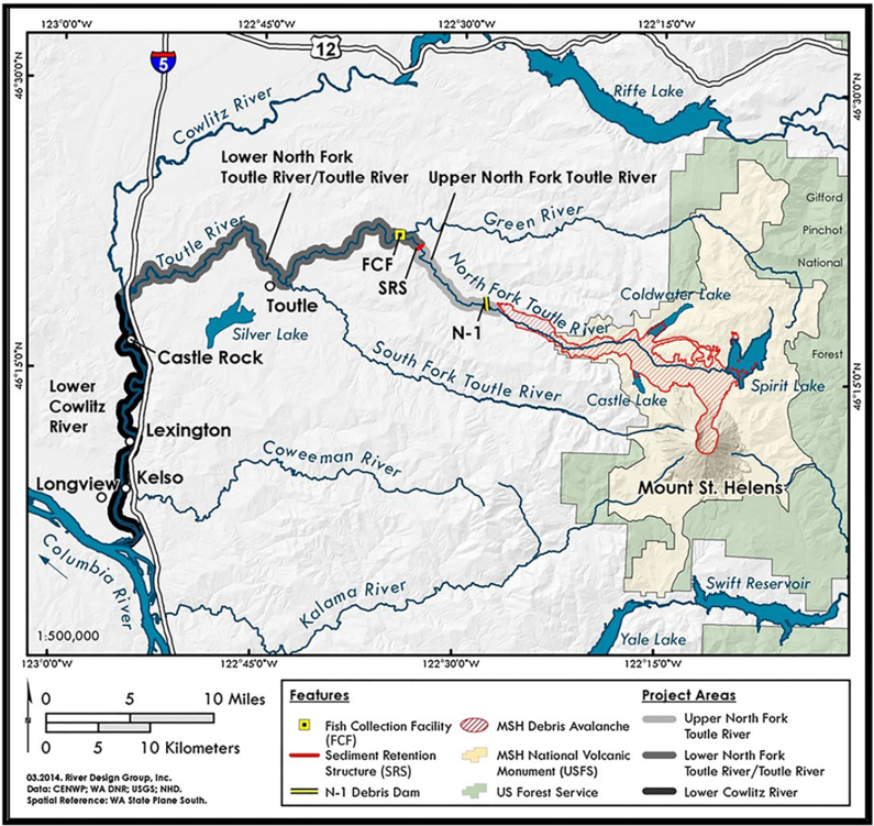
Figure 1 Location map showing Mount St Helens, the Toutle -Cowlitz drainage system extending to the Columbia River, the extent of the debris avalanche, lakes dammed by the debris avalanche, locations of the N-1 dam, Sediment Retention Structure (SRS) and Fish Capture Facility (FCF), and communities along the lower Cowlitz River that are at risk of flooding. Note that most of the debris avalanche itself lies within the Mount St Helens Volcanic Monument, which eliminates options for erosion and sediment source control. [Colour figure can be viewed at wileyonlinelibrary.com]
Figure 1 Location map showing Mount St Helens, the Toutle -Cowlitz drainage system extending to the Columbia River, the extent of the debris avalanche, lakes dammed by the debris avalanche, locations of the N-1 dam, Sediment Retention Structure (SRS) and Fish Capture Facility (FCF), and communities along the lower Cowlitz River that are at risk of flooding. Note that most of the debris avalanche itself lies within the Mount St Helens Volcanic Monument, which eliminates options for erosion and sediment source control. [Colour figure can be viewed at wileyonlinelibrary.com]CC-BY · From the PDF
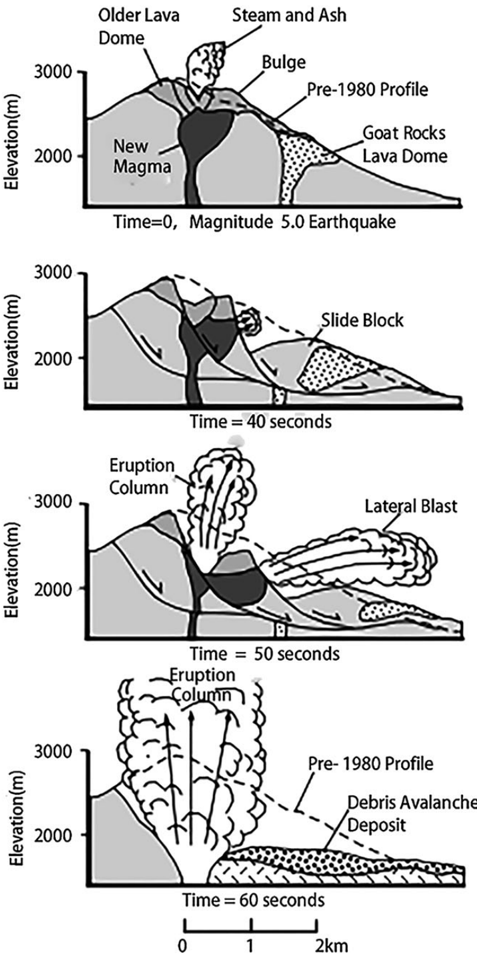
Figure 2 Sequence of events during the first minute of the eruption on 18 May 1980. (A) pre-eruption condition, (B) massive, three-block landslide, (C) lateral blast and pyroclastic flow, (D) debris avalanche burying upper course of North Fork Toutle River (NFTR) to a maximum depth of 140 m. Note: Following the initial event a layer of ash was deposited over the area around the volcano, and lahars and shallow-water floods redistributed debris avalanche and pyroclastic flow sediments downstream through the Toutle -Cowlitz system as far as the Columbia River (see Figure 1) (courtesy of USGS Cascades Volcano Observatory).
Figure 2 Sequence of events during the first minute of the eruption on 18 May 1980. (A) pre-eruption condition, (B) massive, three-block landslide, (C) lateral blast and pyroclastic flow, (D) debris avalanche burying upper course of North Fork Toutle River (NFTR) to a maximum depth of 140 m. Note: Following the initial event a layer of ash was deposited over the area around the volcano, and lahars and shallow-water floods redistributed debris avalanche and pyroclastic flow sediments downstream through the Toutle -Cowlitz system as far as the Columbia River (see Figure 1) (courtesy of USGS Cascades Volcano Observatory).CC-BY · From the PDF
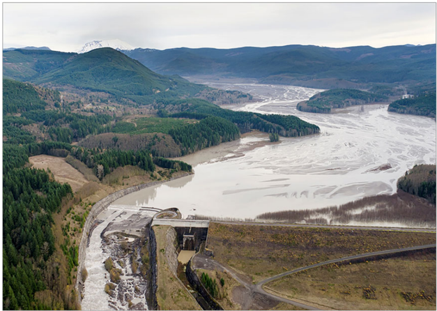
Figure 3 Sediment Retention Structure (SRS) and sediment plain in winter 2012 -2013 (following implementation of the first spillway raise, in summer, 2012) (courtesy of USGS Cascades Volcano Observatory). [Colour figure can be viewed at wileyonlinelibrary.com]
Figure 3 Sediment Retention Structure (SRS) and sediment plain in winter 2012 -2013 (following implementation of the first spillway raise, in summer, 2012) (courtesy of USGS Cascades Volcano Observatory). [Colour figure can be viewed at wileyonlinelibrary.com]CC-BY · From the PDF
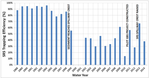
Figure 4 Record of changes in the trap efficiency of the Sediment Retention Structure (SRS) in relation to key events including sediment stored upstream reaching the original spillway crest (March 1998), construction of the Grade Building Structure (GBS) pilot project (summer 2010) and implementation of the pilot spillway raise (summer 2012). [Colour figure can be viewed at wileyonlinelibrary.com]
Figure 4 Record of changes in the trap efficiency of the Sediment Retention Structure (SRS) in relation to key events including sediment stored upstream reaching the original spillway crest (March 1998), construction of the Grade Building Structure (GBS) pilot project (summer 2010) and implementation of the pilot spillway raise (summer 2012). [Colour figure can be viewed at wileyonlinelibrary.com]CC-BY · From the PDF
Figure 5 Sedimentation in the lower Cowlitz River related to the 2006 flood. Such deposition has the potential to rapidly and significantly reduce the Level of Protection (LoP) provided by the lower Cowlitz floodway and levee system. [Colour figure can be viewed at wileyonlinelibrary.com]
Figure 5 Sedimentation in the lower Cowlitz River related to the 2006 flood. Such deposition has the potential to rapidly and significantly reduce the Level of Protection (LoP) provided by the lower Cowlitz floodway and levee system. [Colour figure can be viewed at wileyonlinelibrary.com]CC-BY · From the PDF
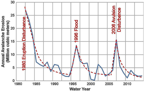
Figure 6 Annual sediment yields to the Sediment Retention Structure (SRS). The 1996 and 2006 floods can be seen to interrupt the longerterm decline in sediment yields, indicating that the fluvial system remains sensitive to disturbance by flood events. The 1996 event was the flood of record. The 2006 flood had a return period of only ~20years but generated a spike in sediment loads due to an avulsion in Loowit Creek -a headwater stream in the North Fork Toutle River (NFTR) basin. Note: This plot uses ' water years ' that start on 1 October and end on 30 September. [Colour figure can be viewed at wileyonlinelibrary.com]
Figure 6 Annual sediment yields to the Sediment Retention Structure (SRS). The 1996 and 2006 floods can be seen to interrupt the longerterm decline in sediment yields, indicating that the fluvial system remains sensitive to disturbance by flood events. The 1996 event was the flood of record. The 2006 flood had a return period of only ~20years but generated a spike in sediment loads due to an avulsion in Loowit Creek -a headwater stream in the North Fork Toutle River (NFTR) basin. Note: This plot uses ' water years ' that start on 1 October and end on 30 September. [Colour figure can be viewed at wileyonlinelibrary.com]CC-BY · From the PDF
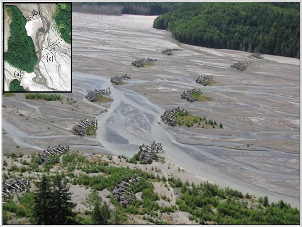
Figure 7 Grade building structures installed in the 2010 Pilot Project. Inset orthophoto shows (a) cutoff berm, (b) cross-valley step-weir and baffle structure, and (c) island building structures. Main picture shows Engineered Log Jam island building structures in area outlined in red in the orthophoto three years after their installation. [Colour figure can be viewed at wileyonlinelibrary.com]
Figure 7 Grade building structures installed in the 2010 Pilot Project. Inset orthophoto shows (a) cutoff berm, (b) cross-valley step-weir and baffle structure, and (c) island building structures. Main picture shows Engineered Log Jam island building structures in area outlined in red in the orthophoto three years after their installation. [Colour figure can be viewed at wileyonlinelibrary.com]CC-BY · From the PDF
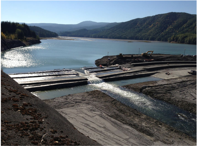
Figure 8 Pilot raise of the Sediment Retention Structure (SRS) spillway under construction during summer 2012. [Colour figure can be viewed at wileyonlinelibrary.com]
Figure 8 Pilot raise of the Sediment Retention Structure (SRS) spillway under construction during summer 2012. [Colour figure can be viewed at wileyonlinelibrary.com]CC-BY · From the PDF
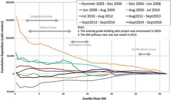
Figure 9 Rates of cumulative sedimentation in the lower Cowlitz River between 2003 and 2013. The impacts of various measures can be discerned. The 2010 Grade Building Structure pilot project slows deposition (compare deposition between August 2009 and July 2010 to that between July 2010 and August 2012), and the 2012 spillway raise reverses sediment deposition in the lower Cowlitz River (i.e. cumulative erosion observed between August 2012 and September 2014). [Colour figure can be viewed at wileyonlinelibrary.com]
Figure 9 Rates of cumulative sedimentation in the lower Cowlitz River between 2003 and 2013. The impacts of various measures can be discerned. The 2010 Grade Building Structure pilot project slows deposition (compare deposition between August 2009 and July 2010 to that between July 2010 and August 2012), and the 2012 spillway raise reverses sediment deposition in the lower Cowlitz River (i.e. cumulative erosion observed between August 2012 and September 2014). [Colour figure can be viewed at wileyonlinelibrary.com]CC-BY · From the PDF
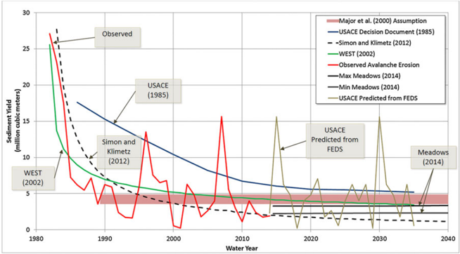
Figure 10 Observed sediment yields from the debris avalanche up to 2014 and predicted in the ' Future Expected Deposition Scenario ' (FEDS) modelled by the Portland District (USACE, 2011a), together with long-term trends in sediment yields forecast in various studies. [Colour figure can be viewed at wileyonlinelibrary.com]
Figure 10 Observed sediment yields from the debris avalanche up to 2014 and predicted in the ' Future Expected Deposition Scenario ' (FEDS) modelled by the Portland District (USACE, 2011a), together with long-term trends in sediment yields forecast in various studies. [Colour figure can be viewed at wileyonlinelibrary.com]CC-BY · From the PDF
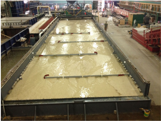
Figure 11 Physical model built at Colorado State University to perform ' proof of concept ' experiments using a series of cross-valley structures to promote aggradation and build up the gradient of the sediment plain by training the braided channel of the North Fork Toutle River (NFTR) into a ' serpentine ' course (Ettema et al ., 2016). [Colour figure can be viewed at wileyonlinelibrary.com]
Figure 11 Physical model built at Colorado State University to perform ' proof of concept ' experiments using a series of cross-valley structures to promote aggradation and build up the gradient of the sediment plain by training the braided channel of the North Fork Toutle River (NFTR) into a ' serpentine ' course (Ettema et al ., 2016). [Colour figure can be viewed at wileyonlinelibrary.com]CC-BY · From the PDF
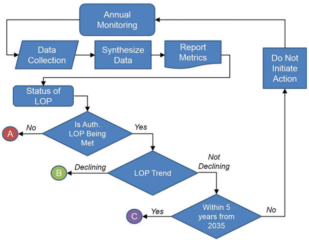
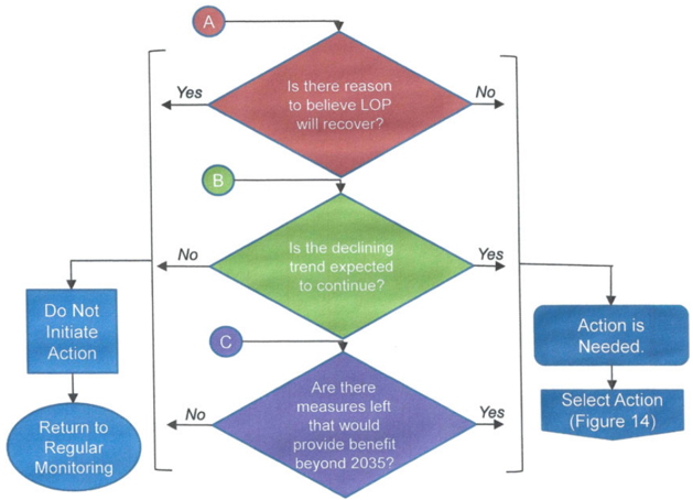
Figure 12 Management Decision Support Framework (MDSF) Step 1. This step considers whether the authorized Level of Protection (LoP) is being met, whether there is a declining trend in the LoP and whether the period for which the Portland District USACE is authorized to manage sediment in the North Fork Toutle River (NFTR) is within five-years of completion. Outcomes A (Red), B (Green) and C (Purple) lead to the matching, colour-coded questions in Step 2 (Figure 13). [Colour figure can be viewed at wileyonlinelibrary.com]
Figure 12 Management Decision Support Framework (MDSF) Step 1. This step considers whether the authorized Level of Protection (LoP) is being met, whether there is a declining trend in the LoP and whether the period for which the Portland District USACE is authorized to manage sediment in the North Fork Toutle River (NFTR) is within five-years of completion. Outcomes A (Red), B (Green) and C (Purple) lead to the matching, colour-coded questions in Step 2 (Figure 13). [Colour figure can be viewed at wileyonlinelibrary.com]CC-BY · From the PDF
Figure 13 Management Decision Support Framework (MDSF) Step 2. This step indicates to the river engineers and scientists responsible for managing sediment in the Toutle -Cowlitz system whether a sediment management action should be triggered or deferred. [Colour figure can be viewed at wileyonlinelibrary.com]
Figure 13 Management Decision Support Framework (MDSF) Step 2. This step indicates to the river engineers and scientists responsible for managing sediment in the Toutle -Cowlitz system whether a sediment management action should be triggered or deferred. [Colour figure can be viewed at wileyonlinelibrary.com]CC-BY · From the PDF
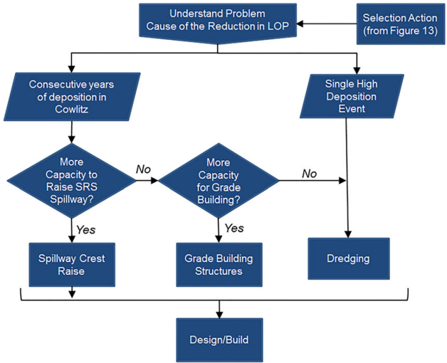
Figure 14 Management Decision Support Framework (MDSF) Step 3. This set guides decision-makers with respect to the appropriate sediment management action on the basis of the wider context for the need for action and the options available. [Colour figure can be viewed at wileyonlinelibrary.com]
Figure 14 Management Decision Support Framework (MDSF) Step 3. This set guides decision-makers with respect to the appropriate sediment management action on the basis of the wider context for the need for action and the options available. [Colour figure can be viewed at wileyonlinelibrary.com]CC-BY · From the PDF

Verification

Claims the paper makes

The claims and statistics of this paper haven’t been checked yet.

Run the check — free, no account needed. It reads the open-access text and checks the sources it cites.

A few free checks a day · papers already verified open instantly · results are public

Claims other papers make about this one

Each is checked against this paper’s own text: does it say what the citing paper says it does?

Self-check

Percentages, sums and reported differences re-computed from the paper’s own numbers.

The self-check needs the paper’s full text.

Citations

Cites

No references could be resolved yet.

Research works printed but not linked: 52

  1. 10.21236/ADA581331 · DOI
  2. Brunner GW, 2001, HEC‐RAS River Analysis System: User's Manual
  3. Cederholm CJ, 1991, Fisheries Bioengineering Symposium: American Fisheries Society Symposium 10, 104
  4. 10.1002/esp.3478 · DOI
  5. 10.1016/j.jvolgeores.2013.01.010 · DOI
  6. 10.3133/ofr20111317 · DOI
  7. Ettema R, 2016, Hydraulic Model Study of Grade‐Building Structures for the North Fork Toutle River, Washington
  8. 10.3133/ofr96677 · DOI
  9. 10.2475/ajs.277.2.178 · DOI
  10. 10.1130/G31682.1 · DOI · Paper page
  11. Hamlet AF, 2010, Final Project Report for the Columbia Basin Climate Change Scenarios Project
  12. 10.1080/07055900.2013.819555 · DOI
  13. Hoblitt RP, 1981, Origin and Stratigraphy of the Deposit Produced by the May 18 Directed Blast, 401
  14. Janda RJ, 1984, Sedimentation and geomorphic changes during and following the 1980–1983 eruptions of Mount St. Helens, Washington, Shin Sabo, 37, 10
  15. 10.3133/pp1250 · DOI
  16. 10.1029/2002JF000010 · DOI
  17. 10.1130/0091-7613(2000)28<819:SYFSVD>2.0.CO;2 · DOI
  18. MajorJJ CrisafulliCM FrenzenP BishopJ.2009 After the disaster: the hydrogeomorphic ecological and biological responses to the 1980 eruption of Mount St. Helens Washington. InVolcanoes to Vineyards: Geologic Field Trips through the Dynamic Landscape of the Pacific Northwest O'ConnorJE DorseyRJ MadinIP(eds) Geological Society of America Field Guide 15. The Geological Society of America:Boulder CO;111–134.https://doi.org/10.1130/2009.fld015(06) · DOI
  19. MeadowsT.2014.Forecasting Long‐term Sediment Yield from the Upper North Fork Toutle River Mount St. Helens USA PhD Thesis. School of Geography University of Nottingham; 393 pp.http://eprints.nottingham.ac.uk/27800/1/Thesis_FINAL_TM.pdf
  20. 10.3133/ds951 · DOI
  21. PetersonNP ReidLM.1984.Wall‐base channels: their evolution distribution and use by juvenile coho salmon in the Clearwater River Washington. Proceedings of the Olympic Wild Fish Conference. Fisheries Technology Program Peninsula College Port Angeles WA; 215–225.
  22. 10.1146/annurev-earth-060313-054913 · DOI · Paper page
  23. Schumm SA, 1977, The Fluvial System, 338
  24. 10.2113/gseegeosci.xx.2.125 · DOI
  25. Simon A, 1999, Channel and Drainage‐basin Response of the Toutle River System in the Aftermath of the 1980 Eruption of Mount St. Helens, Washington, 130
  26. Simon A, 2012, Analysis of Long‐term Sediment Loadings from the Upper North Fork Toutle River System, Mount St. Helens, Washington
  27. 10.1002/(SICI)1096-9837(199602)21:2<155::AID-ESP610>3.0.CO;2-5 · DOI
  28. 10.1029/2010GM001006 · DOI
  29. 10.1007/0-387-28150-9_3 · DOI
  30. 10.1111/jawr.12199 · DOI
  31. US Army Corps of Engineers (USACE), 1983, A Comprehensive Plan for Responding to the Long‐term Threat Created by the Eruption of Mount St. Helens, Washington
  32. US Army Corps of Engineers (USACE), 1984, Mount St. Helens, Washington Feasibility Report and Environmental Impact Statement, Toutle, Cowlitz and Columbia Rivers
  33. US Army Corps of Engineers (USACE), 1985, Mount St. Helens, Washington Decision Document, Toutle, Cowlitz and Columbia Rivers
  34. US Army Corps of Engineers (USACE), 1986, Mount St. Helens, Washington, Toutle, Cowlitz and Columbia Rivers, Design Memorandum No. 3 (September)
  35. US Army Corps of Engineers (USACE), 1986, Mount St. Helens Sediment Control, Cowlitz and Toutle Rivers, Washington, Sediment Retention Structure Sediment Ranges, Design Memorandum No. 11 (December)
  36. US Army Corps of Engineers (USACE), 1987, Mount St. Helens Sediment Control, Cowlitz, and Toutle Rivers, Washington, Design Memorandum No. 10, Sediment Retention Structure Fish Collection Facility
  37. US Army Corps of Engineers (USACE), 1987, Mount St. Helens Washington, Toutle, Cowlitz and Columbia Rivers, Design Memorandum No. 15 (September): SRS Base‐plus Dredging
  38. US Army Corps of Engineers (USACE), 1990, Numerical Simulation of Mudflows from Hypothetical Failures of the Castle Lake Debris Blockage Near Mount St. Helens, WA: Final Project Report No. 90–05
  39. US Army Corps of Engineers (USACE), 2009, Toutle/Cowlitz River Sediment Budget (October 2009)
  40. US Army Corps of Engineers (USACE), 2010, Progress Report, Mount St. Helens Long‐Term Sediment Management Plan for Flood Risk Reduction (June 2010)
  41. US Army Corps of Engineers (USACE), 2011, Mount St. Helens Future Expected Deposition Scenario (FEDS) (April 2011)
  42. US Army Corps of Engineers (USACE), 2011, Development of the PMF for the SRS (August 2011)
  43. US Army Corps of Engineers (USACE), 2012, White Paper Describing Differences between 1985 and 2011 Probable Maximum Flood at the Sediment Retention Structure, North Fork Toutle River, WA
  44. US Army Corps of Engineers (USACE), 2013, Mount St. Helens, Washington, Design Documentation Report No. 16 (June), Sediment Retention Structure 7‐foot Spillway Raise
  45. US Army Corps of Engineers (USACE), 2014, Limited Reevaluation Report: Mount St Helens Long‐term Sediment Management Plan Update (Draft)
  46. US Army Corps of Engineers (USACE), 2015, Final Supplemental Environmental Impact Statement, Mount St. Helens Long‐term Sediment Management Plan Update
  47. Voight B, 1981, Catastrophic Rockslide Avalanche of May 18, 347
  48. Waitt RB, 1981, The 1980 Eruptions of Mount St. Helens, Washington, 439
  49. Consultants WEST, 2002, Mount St Helens engineering reanalysis. Hydrologic, hydraulic and sedimentation analysis. Volume 1
  50. Willingham WF, 2005, The Army Corps of Engineers’ short‐term response to the eruption of Mount St. Helens, Oregon Historical Quarterly, 106, 174, 10.1353/ohq.2005.0074 · DOI
  51. 10.1016/j.geomorph.2013.11.018 · DOI
  52. 10.1002/rra.3142 · DOI

Cited by

Metadata

Authors
Sclafani, P., Nygaard, C., & Thorne, C.
Venue
Earth Surface Processes and Landforms
Publisher
Wiley
Published
2017-12-14
Volume
43
Issue
5
Pages
1088-1104
ISSN
  • 0197-9337
  • 1096-9837
Cited by
11
References
0
Language
en

About these checks

Registry, retraction, Cites and statistics results are computed, not judged, with one exception: a printed reference that no index lists is read once by a model before it counts as a citation error. Claims are extracted by a model and kept only when their quote appears verbatim in the text; each cited source is then checked, with a model’s help, for whether it says what the claim relies on. Those verdicts can be wrong — read the claim’s quote and the cited source before relying on one.

Statistics and arithmetic are recomputed, not judged.

Confidence bands are shown only for fields calibrated on our annotated test set. None is calibrated yet, so no band is shown.

What counts as a claim ›How we measure confidence ›How we check this ›

Are you an author, or do you see a problem with this page? Request a review