

Mitigating high latitude ionospheric scintillation effects on GNSS Precise Point Positioning exploiting 1-s scintillation indices
Open accessThe DOI matches its Crossref record; 49 of the 49 references it cites were found in a registry or an index.
Abstract
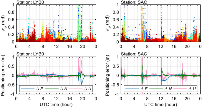
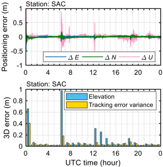
Ionospheric scintillation refers to rapid and random fluctuations in radio frequency signal intensity and phase, which occurs more frequently and severely at high latitudes under strong solar and geomagnetic activity. As one of the most challenging error sources affecting Global Navigation Satellite System (GNSS), scintillation can significantly degrade the performance of GNSS receivers, thereby leading to increased positioning errors. This study analyzes Global Positioning System (GPS) scintillation data recorded by two ionospheric scintillation monitoring receivers operational, respectively, in the Arctic and northern Canada during a geomagnetic storm in 2019. A novel approach is proposed to calculate 1-s scintillation indices. The 1-s receiver tracking error variances are then estimated, which are further used to mitigate the high latitude scintillation effects on GPS Precise Point Positioning. Results show that the 1-s scintillation indices can describe the signal fluctuations under scintillation more accurately. With the mitigation approach, the 3D positioning error is greatly reduced under scintillation analyzed in this study. Additionally, the 1-s tracking error variance achieves a better performance in scintillation mitigation compared with the previous approach which exploits 1-min tracking error variance estimated by the commonly used 1-min scintillation indices. This work is relevant for a better understanding of the high latitude scintillation effects on GNSS and is also beneficial for developing scintillation mitigation tools for GNSS positioning.
Overview
The claims and statistics of this paper haven’t been checked yet.
Free: it reads the open-access text and checks the first 5 claims that cite a source we can check. Create a free account to check every claim.
Integrity signals
Registry
Cites
Statistics
Figures






Verification
Claims the paper makes
The claims and statistics of this paper haven’t been checked yet.
Free: it reads the open-access text and checks the first 5 claims that cite a source we can check. Create a free account to check every claim.
Self-check
Percentages, sums and reported differences re-computed from the paper’s own numbers.
The self-check needs the paper’s full text.
Citations
Cites
Ionospheric Time-Delay Algorithm for Single-Frequency GPS Users
Klobuchar, J. (1987) · IEEE Transactions on Aerospace and Electronic Systems · doi:10.1109/taes.1987.310829 · Cited by 1,494 · cited 1×
“This usually leads to a worse accuracy of GNSS global broadcast ionospheric delay correction model for single-frequency users, which results in greater positioning error (Klobuchar 1987; Prieto-Cerdeira et al.”
BackgroundGlobal morphology of ionospheric scintillations
Aarons, J. (1982) · Proceedings of the IEEE · doi:10.1109/proc.1982.12314 · Cited by 561 · cited 1×
“1988; Aarons 1982), roughly modulated by the solar and geomagnetic activities (Aarons et al.”
BackgroundA power law phase screen model for ionospheric scintillation: 1. Weak scatter
Rino, C. L. (1979) · Radio Science · doi:10.1029/rs014i006p01135 · Cited by 462 · cited 3×
“The power spectral density (PSD) of phase scintillation is modeled as (Rino 1979) where f0 is the frequency corresponding to the outer scale size of irregularities. f is the frequency component composing the detrended phase measurements. p is the spectral index corresponding to the opposite of the…”
BackgroundMethodInfluentialGlobal morphology of ionospheric scintillations
Aarons, J., Whitney, H. E., & Allen, R. S. (1971) · Proceedings of the IEEE · doi:10.1109/proc.1971.8122 · Cited by 455
Ionospheric constraints on VHF/UHF communications links during solar maximum and minimum periods
Basu, S., MacKenzie, E., & Basu, S. (1988) · Radio Science · doi:10.1029/rs023i003p00363 · Cited by 361
Ionospheric Scintillation Monitoring Using Commercial Single Frequency C/A Code Receivers
Dierendonck, A. J. V., Klobuchar, J. A., & Hua, Q. (1993) · Proceedings of the 6th International Technical Meeting of the Satellite Division of The Institute of Navigation (ION GPS 1993) · Cited by 350
Basu, S., Groves, K. M., Basu, S., & Sultan, P. J. (2002) · Journal of Atmospheric and Solar-Terrestrial Physics · doi:10.1016/s1364-6826(02)00124-4 · Cited by 328
Conker, R. S., El‐Arini, M. B., Hegarty, C. J., & Hsiao, T. (2003) · Radio Science · doi:10.1029/2000rs002604 · Cited by 295
A new automated cycle slip detection and repair method for a single dual-frequency GPS receiver
Liu, Z. (2011) · Journal of Geodesy · doi:10.1007/s00190-010-0426-y · Cited by 217 · cited 1×
“…(MWWL) combination, involving code and carrier phase measurements on L1C/A and L2P signals, and ionospheric total electron contents rates (TECRs), involving the geometry-free combination of L1 and L2 carrier phase measurements, are both calculated to jointly detect the cycle slips (Liu 2011).”
MethodCanadian High Arctic Ionospheric Network (CHAIN)
Jayachandran, P. T., Langley, R. B., MacDougall, J. W., Mushini, S. C., Pokhotelov, D., Hamza, A. M., Mann, I. R., Milling, D. K., Kale, Z. C., Chadwick, R., et al. (2009) · Radio Science · doi:10.1029/2008rs004046 · Cited by 211
Research works printed but not linked: 2
- Bougard B, Simsky A, Sleewaegen JM, Park J, Aquino M, Spogli L, Romano V, Mendonça M, Galera Monico JF (2013) CALIBRA: mitigating the impact of ionospheric scintillation on precise point 30 Page 14 of 15 positioning in Brazil. In: 7th GNSS vulnerabilities and solutions conference
- Prieto-Cerdeira R, Orus-Peres R, Breeuwer E, Lucas-Rodriguez R, Falcone M (2014) Performance of the Galileo single-frequency ionospheric correction during in-orbit validation. GPS World 25(6):53-58
Cited by
Luo, X., Du, J., Monico, J. F. G., Xiong, C., Liu, J., & Liang, X. (2022) · Space Weather · doi:10.1029/2022sw003114 · Cited by 29
The implications of ionospheric disturbances for precise GNSS positioning in Greenland
Paziewski, J., Høeg, P., Sieradzki, R., Jin, Y., Jarmolowski, W., Hoque, M. M., Berdermann, J., Hernandez-Pajares, M., Wielgosz, P., Lyu, H., et al. (2022) · Journal of Space Weather and Space Climate · doi:10.1051/swsc/2022029 · Cited by 27
“These studies were followed by Guo et al. (2021), who proposed and validated a novel method for mitigating the high latitude scintillation effects on PPP using the dataset collected in the Arctic and northern Canada during the geomagnetic storm in 2019.”
MethodNguyen, C. T., Oluwadare, T. S., Le, N., Alizadeh, M. M., Wickert, J., & Schuh, H. (2021) · Remote Sensing · doi:10.3390/rs14010010 · Cited by 28
“Scintillation activities occur less frequently in high-latitude areas than in the equator, although are more difficult to predict because they can appear at any time of day [24].”
BackgroundNishimura, Y., Kelly, T. D., Jayachandran, P. T., Mrak, S., Semeter, J. L., Donovan, E., Angelopoulos, V., & Nishitani, N. (2023) · Journal of Geophysical Research Space Physics · doi:10.1029/2023ja031402 · Cited by 22
Zhao, D., Li, W., Li, C., Tang, X., Wang, Q., Hancock, C. M., Roberts, G. W., & Zhang, K. F. (2022) · Space Weather · doi:10.1029/2021sw003015 · Cited by 22
“Therefore, the investigation on extracting the ionospheric scintillation index more accurately is of great significance for scientific understanding about the occurrence of ionospheric scintillation, thereby reducing the adverse effect of ionospheric scintillation (Guo et al., 2021; Xu et al., 2020).”
Background
Metadata
- Authors
- Guo, K., Vadakke Veettil, S., Weaver, B. J., & Aquino, M.
- Affiliations
- University of Nottingham (GB)
- Corresponding author
- Guo, Kai
- Venue
- Journal of Geodesy
- Published
- 2021-02-22
- Volume
- 95
- Issue
- 3
- ISSN
- 0949-7714 (ISSN-L)
- 1432-1394
- OpenAlex
- W3130682789
- Cited by
- 21
- References
- 48
- Citations by year
- 2026: 4 · 2025: 3 · 2024: 1 · 2023: 3 · 2022: 4 · 2021: 6
- FWCI
- 1.81
- Type
- journal article
- Language
- en
- Open access
- hybrid
- doi.org
- Licence
- cc-by
- creativecommons.org/licenses/by/4.0 (tdm)
- creativecommons.org/licenses/by/4.0 (vor)
- Locations
- Journal of Geodesy (publishedVersion, cc-by)
- Repository@Nottingham (University of Nottingham) (publishedVersion, cc-by)
- Repository@Nottingham (University of Nottingham) (submittedVersion, cc-by)
- Funders
- H2020 Marie Skłodowska-Curie Actions (722023)
- Topics
- Physical Sciences › Engineering › Aerospace Engineering › GNSS positioning and interference
- Physical Sciences › Earth and Planetary Sciences › Space and Planetary Science › Ionosphere and magnetosphere dynamics
- Physical Sciences › Mathematics › Applied Mathematics › Statistical and numerical algorithms
- Keywords
- ionospheric scintillation, precise point positioning, tracking error variance, scintillation mitigation, high-latitude ionosphere, geomagnetic storms, Arctic, positioning error, GNSS positioning accuracy
About these checks
Registry, retraction, Cites and statistics results are computed, not judged, with one exception: a printed reference that no index lists is read once by a model before it counts as a citation error. Claims are extracted by a model and kept only when their quote appears verbatim in the text; each cited source is then checked, with a model’s help, for whether it says what the claim relies on. Those verdicts can be wrong — read the claim’s quote and the cited source before relying on one.
Statistics and arithmetic are recomputed, not judged.
Confidence bands are shown only for fields calibrated on our annotated test set. None is calibrated yet, so no band is shown.
What counts as a claim ›How we measure confidence ›How we check this ›
Are you an author, or do you see a problem with this page? Request a review
How to cite
Cite CoChat for the checks on this page, and the paper for its own findings.
- This page
- CoChat. (2026). Citation check: Mitigating high latitude ionospheric scintillation effects on GNSS Precise Point Positioning exploiting 1-s scintillation indices. https://app.cochat.ai/papers/10.1007/s00190-021-01475-y
- The paper
- Guo, K., Vadakke Veettil, S., Weaver, B. J., & Aquino, M. (2021). Mitigating high latitude ionospheric scintillation effects on GNSS Precise Point Positioning exploiting 1-s scintillation indices. Journal of Geodesy. https://doi.org/10.1007/s00190-021-01475-y
Data sources
Bibliographic data: Semantic Scholar, OpenAlex, Crossref.
Contains information from the Semantic Scholar Academic Graph Datasets, made available under the ODC Attribution License (ODC-BY 1.0).
Semantic Scholar’s data is described in: Kinney, R., et al. (2023). The Semantic Scholar Open Data Platform. arXiv:2301.10140.
