

The DOI matches its Crossref record; 56 of the 56 references it cites were found in a registry or an index; none of the 16 sources its claims cite is checked for support yet.
Space‐Borne Cloud‐Native Satellite‐Derived Bathymetry (SDB) Models Using ICESat‐2 And Sentinel‐2
Open accessPublished version of a preprint
Abstract
Shallow nearshore coastal waters provide a wealth of societal, economic, and ecosystem services, yet their topographic structure is poorly mapped due to a reliance upon expensive and time intensive methods. Space‐borne bathymetric mapping has helped address these issues, but has remained largely dependent upon in situ measurements. Here we fuse ICESat‐2 lidar data with Sentinel‐2 optical imagery, within the Google Earth Engine cloud platform, to create openly available spatially continuous high‐resolution bathymetric maps at regional‐to‐national scales in Florida, Crete and Bermuda. ICESat‐2 bathymetric classified photons are used to train three Satellite Derived Bathymetry (SDB) methods, including Lyzenga, Stumpf, and Support Vector Regression algorithms. For each study site the Lyzenga algorithm yielded the lowest RMSE (approx. 10%–15%) when compared with validation data. We demonstrate a means of using ICESat‐2 for both model calibration and validation, thus cementing a pathway for fully space‐borne estimates of nearshore bathymetry in shallow, clear water environments.
Overview
CoChat Summary
TL;DR
The paper fuses ICESat-2 lidar and Sentinel-2 imagery in Google Earth Engine to produce fully space-borne satellite-derived bathymetry maps in Bermuda, Biscayne Bay, and Crete. Across three SDB methods, cluster-based Lyzenga (CBL) gave the lowest errors, with RMSE 2.62 m, 0.83 m, and 2.19 m respectively.
Key findings
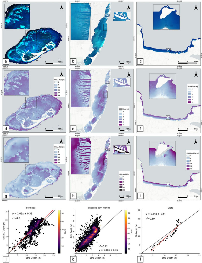
- CBL produced the most reliable SDB estimates at all sites: RMSE 2.62 m (Bermuda), 0.83 m (Biscayne Bay), and 2.19 m (Crete); MAE 2.00 m, 0.65 m, and 2.02 m; R² 0.68, 0.79, and 0.83; maximum modeled depths 26 m, 5 m, and 22 m.
- CBL RMSEs were lower than or close to 10% of maximum depth for Bermuda and Crete, but close to 17% for Biscayne Bay; SVR tended to underestimate the range of depths although its errors did not differ much from CBL.
- L2A and L1C errors were comparable, indicating that computationally expensive atmospheric correction is not needed for accurate SDB retrieval in shallow coastal environments.
- ICESat-2 was used for both model calibration and validation, supporting a pathway to fully space-borne nearshore bathymetry; the SDB models captured bathymetric relief and rugosity in shallow and coral reef areas in more detail than the NOAA DEM.
Methods
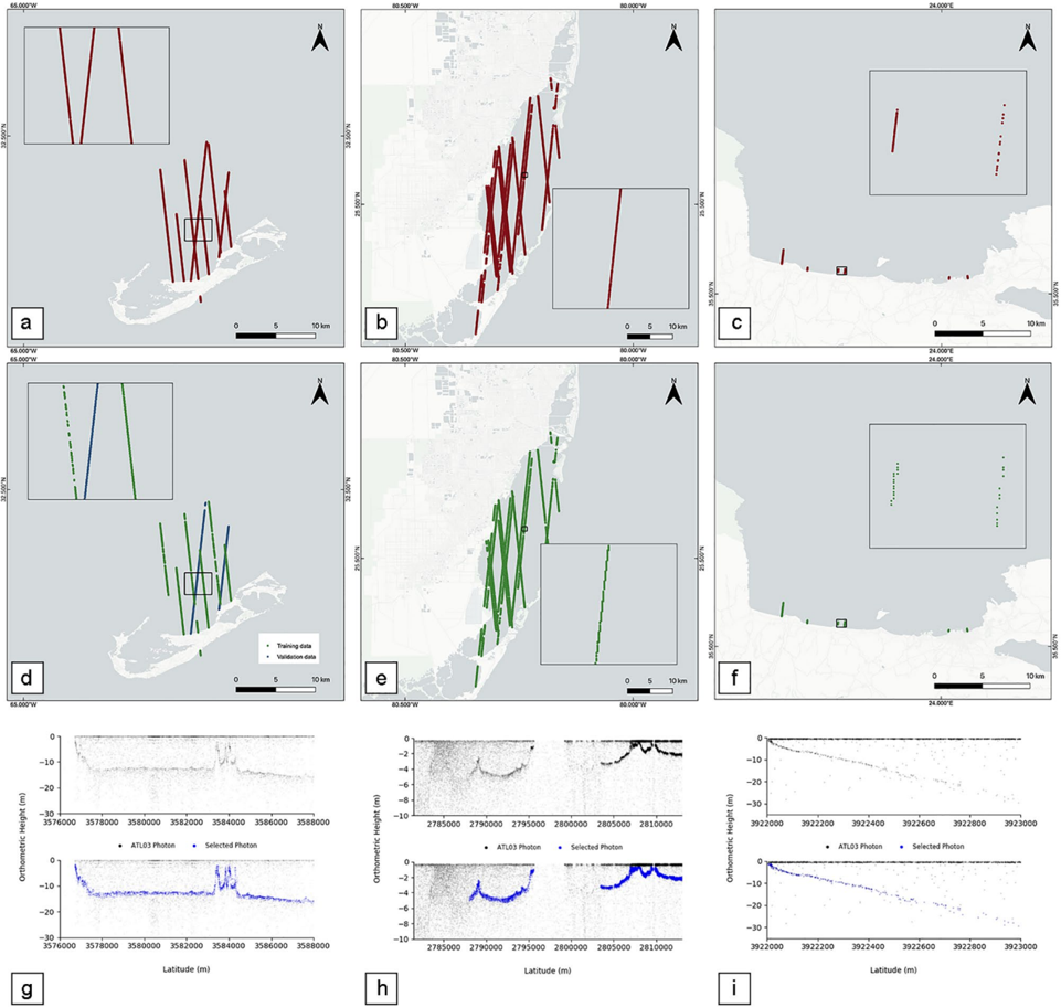
- A cloud-native Google Earth Engine workflow combined multi-temporal Sentinel-2 A/B data (B1–B4, 20th-percentile mosaic after cloud masking) with ICESat-2 ATL03 photons corrected for refraction, using high-power beams and “Land Confidence” level 4 photons aggregated to a 10-m Sentinel-2 grid.
- Three SDB models were trained: CBL (cluster-based regression with Lyzenga log-linear regression using B1–B4), CBS (cluster-based regression with Stumpf log-ratio using B3/B2), and SVR (epsilon-SVR with linear kernel on the first four log-transformed Sentinel-2 bands); k-means clustering with five clusters was used for Bermuda and Biscayne Bay, but not for Crete due to its predominantly homogeneous sandy seabed.
- Accuracy assessment used an 80/20 training/validation split: Bermuda used 5,173 ICESat-2 training points and 1,293 ICESat-2 validation points; Biscayne Bay used 34,342 ICESat-2 training points and 8,585 NOAA DEM validation points; Crete used 133 ICESat-2 training points and 85 in-situ singlebeam validation points; metrics were RMSE, MAE, R², and standard deviation.
Limitations
- Stated: manual selection of ICESat-2 bathymetric photons is a potential source of user-interpretation error, especially where ICESat-2 served as both training and validation data (Bermuda and Crete); tide-level mismatch between Sentinel-2 20th-percentile composites and ICESat-2 acquisition dates is non-negligible but assumed small for the microtidal (<1 m) study sites.
- Stated: Biscayne Bay ICESat-2 could not detect the bottom of dredged channels due to sediment/turbidity or limited photon penetration; Crete SDB underpredicted depths greater than 15 m where water is optically deep and the relationship becomes non-linear; Bermuda NOAA DEM validation was poor (r² = 0.14) due to low temporal/spatial resolution and interpolation.
- Evident: validation data quality and independence vary by site (e.g., Crete validation used only 85 in-situ points; Bermuda validation used ICESat-2, though from different passes/days), and the approach is limited to shallow, clear, optically shallow water environments.
Model-written summary. Check it against the paper before relying on it.
Integrity signals
Registry
Cites
Statistics
Figures


Verification
Claims the paper makes
0 Valid · 1 Not valid · 13 Not checked · 54 Own results and interpretations
A result the paper states — it cites no source for it, so there is none to check. The quote shows it is in the paper.
In the paper
“For the Crete study site, however, the SDB models underpredict the deeper depths, specifically greater than a depth of 15 m, where the water is optically deep.”
§ Space-Borne Cloud-Native Satellite-Derived Bathymetry (SDB) Models Using ICESat-2 And Sentinel-2 > 3.1. Comparison with Publicly Available DEM Data
plainstates an associationSingle case- Asserted: passes — The authors put it forward as true.
- Checkable: passes — It can be checked against evidence.
- Load-bearing: unclear — It is unclear whether the paper’s conclusions depend on it.
- Based: passes — The paper gives a reason why it holds.
A result the paper reports from its own data — it cites no other source for it, so there is none to check. The quote shows it is in the paper.
In the paper
“Prior to selecting the relevant bands for modeling, we performed preliminary statistical tests with various combinations of Sentinel-2 bands with this method, and acquired the best accuracy with the multilinear regression of B1, B2, B3, and B4.”
§ Space-Borne Cloud-Native Satellite-Derived Bathymetry (SDB) Models Using ICESat-2 And Sentinel-2 > 2.3.2. Sentinel-2 Satellite Derived Bathymetry (SDB)
plainstates an association- Asserted: passes — The authors put it forward as true.
- Checkable: passes — It can be checked against evidence.
- Load-bearing: passes — The paper’s conclusions depend on it.
- Based: passes — The paper gives a reason why it holds.
A result the paper states — it cites no source for it, so there is none to check. The quote shows it is in the paper.
In the paper
“For these reasons, we observe high residuals between the Bermuda SDB and NOAA DEM in the coral reef complexes (Figures 2d and 2g).”
§ Space-Borne Cloud-Native Satellite-Derived Bathymetry (SDB) Models Using ICESat-2 And Sentinel-2 > 3.1. Comparison with Publicly Available DEM Data
plainstates an association- Asserted: passes — The authors put it forward as true.
- Checkable: passes — It can be checked against evidence.
- Load-bearing: passes — The paper’s conclusions depend on it.
- Based: passes — The paper gives a reason why it holds.
A result the paper reports from its own data — it cites no other source for it, so there is none to check. The quote shows it is in the paper.
In the paper
“Based on preliminary models, the use of photons with the highest confidence values alone improved the model accuracy.”
§ Space-Borne Cloud-Native Satellite-Derived Bathymetry (SDB) Models Using ICESat-2 And Sentinel-2 > 2.3.1. ICESat-2 Bathymetric Photons
hedgedstates a cause- Asserted: passes — The authors put it forward as true.
- Checkable: passes — It can be checked against evidence.
- Load-bearing: unclear — It is unclear whether the paper’s conclusions depend on it.
- Based: passes — The paper gives a reason why it holds.
A result the paper states — it cites no source for it, so there is none to check. The quote shows it is in the paper.
In the paper
“Here the relationship between ICESat-2 reference depths and the log-transformed Sentinel-2 reflectance values become non-linear.”
§ Space-Borne Cloud-Native Satellite-Derived Bathymetry (SDB) Models Using ICESat-2 And Sentinel-2 > 3.1. Comparison with Publicly Available DEM Data
plainstates an associationSingle case- Asserted: passes — The authors put it forward as true.
- Checkable: passes — It can be checked against evidence.
- Load-bearing: unclear — It is unclear whether the paper’s conclusions depend on it.
- Based: passes — The paper gives a reason why it holds.
29 more claims
Create a free account to see all 68 claims and to verify the 13 references still open.
- It may state two separate claims as one. 23
- Probably not a substantial claim. 13
Self-check
Percentages, sums and reported differences re-computed from the paper’s own numbers.
Each contradiction between two passages listed here was confirmed by an independent check.
Rated major: it would touch a result — a value a result rests on, reported and recomputed p-values on opposite sides of the significance level, two passages that conflict with no sign which is right, or a cited work retracted before this paper was published.
In the paper
§ Space-Borne Cloud-Native Satellite-Derived Bathymetry (SDB) Models Using ICESat-2 And Sentinel-2 > 3. Results
“The R 2 of the models for Bermuda, Biscayne Bay, and Crete were 0.68, 0.79, and 0.83, respectively (Figures 2j-2l).”
§ Space-Borne Cloud-Native Satellite-Derived Bathymetry (SDB) Models Using ICESat-2 And Sentinel-2 > 4. Discussion and Conclusions
“| Bermuda | CBL | 2.62 | 2.00 | 0.83 4.48 0.58 | 26 | | |”
Rated minor: it would not touch a result — a value no result rests on, a p-value that stays on the same side of the significance level, or a conflict that is clerical, resolved elsewhere in the paper, or outside its own findings.
In the paper
§ Space-Borne Cloud-Native Satellite-Derived Bathymetry (SDB) Models Using ICESat-2 And Sentinel-2 > 2.4. Reference Data and Accuracy Assessment
“Training and validation sample sizes were based on an 80/20 rule with 80% of the sample size used for training and 20% used for validation.”
§ Space-Borne Cloud-Native Satellite-Derived Bathymetry (SDB) Models Using ICESat-2 And Sentinel-2 > 2.4. Reference Data and Accuracy Assessment
“Lastly, an amalgamation of training with ICESat-2 data (133 points) and with validation data collected from in-situ singlebeam data (85 points) was used in Crete.”
Rated minor: it would not touch a result — a value no result rests on, a p-value that stays on the same side of the significance level, or a conflict that is clerical, resolved elsewhere in the paper, or outside its own findings.
In the paper
§ Space-Borne Cloud-Native Satellite-Derived Bathymetry (SDB) Models Using ICESat-2 And Sentinel-2 > 3.1. Comparison with Publicly Available DEM Data
“In addition the DEM is composed of 63 years worth of data and therefore changes are expected to have occurred due to hurricanes, dredging and other anthropogenic changes (Lester et al., 2016;Smith et al., 2013).”
§ Space-Borne Cloud-Native Satellite-Derived Bathymetry (SDB) Models Using ICESat-2 And Sentinel-2 > 2.1.3.1. NOAA Bathymetry
“The Bermuda DEM, at a resolution of 30-90 m, was collected by multiple institutions over a 20 year period (1993-2012;Sutherland et al., 2013).”
Citations
Cites
Google Earth Engine: Planetary-scale geospatial analysis for everyone
Gorelick, N., Hancher, M., Dixon, M., Ilyushchenko, S., Thau, D., & Moore, R. (2017) · Remote Sensing of Environment · doi:10.1016/j.rse.2017.06.031 · Cited by 14,719
(2007) · doi:10.5555/1283383.1283494 · Cited by 7,364
Global Multi‐Resolution Topography synthesis
Ryan, W. B. F., Carbotte, S. M., Coplan, J. O., O'Hara, S., Melkonian, A., Arko, R., Weissel, R. A., Ferrini, V., Goodwillie, A., Nitsche, F., et al. (2009) · Geochemistry, Geophysics, Geosystems · doi:10.1029/2008gc002332 · Cited by 2,122
Markus, T., Neumann, T., Martino, A., Abdalati, W., Brunt, K., Csatho, B., Farrell, S., Fricker, H., Gardner, A., Harding, D., et al. (2017) · Remote Sensing of Environment · doi:10.1016/j.rse.2016.12.029 · Cited by 1,215
Determination of water depth with high‐resolution satellite imagery over variable bottom types
Stumpf, R. P., Holderied, K., & Sinclair, M. (2003) · Limnology and Oceanography · doi:10.4319/lo.2003.48.1_part_2.0547 · Cited by 1,167
The Effectiveness, Costs and Coastal Protection Benefits of Natural and Nature-Based Defences
Narayan, S., Beck, M. W., Reguero, B. G., Losada, I. J., van Wesenbeeck, B., Pontee, N., Sanchirico, J. N., Ingram, J. C., Lange, G.-M., & Burks-Copes, K. A. (2016) · PLOS ONE · doi:10.1371/journal.pone.0154735 · Cited by 795
The role of ecosystems in coastal protection: Adapting to climate change and coastal hazards
Spalding, M. D., Ruffo, S., Lacambra, C., Meliane, I., Hale, L. Z., Shepard, C. C., & Beck, M. W. (2014) · Ocean & Coastal Management · doi:10.1016/j.ocecoaman.2013.09.007 · Cited by 701
Guiding ecological principles for marine spatial planning
Foley, M. M., Halpern, B. S., Micheli, F., Armsby, M. H., Caldwell, M. R., Crain, C. M., Prahler, E., Rohr, N., Sivas, D., Beck, M. W., et al. (2010) · Marine Policy · doi:10.1016/j.marpol.2010.02.001 · Cited by 571
Multispectral bathymetry using a simple physically based algorithm
Lyzenga, D. R., Malinas, N. P., & Tanis, F. J. (2006) · IEEE Transactions on Geoscience and Remote Sensing · doi:10.1109/tgrs.2006.872909 · Cited by 566
Validation of ICESat-2 ATLAS Bathymetry and Analysis of ATLAS’s Bathymetric Mapping Performance
Parrish, C., Magruder, L., Neuenschwander, A., Forfinski-Sarkozi, N., Alonzo, M., & Jasinski, M. (2019) · Remote Sensing · doi:10.3390/rs11141634 · Cited by 421
Research works printed but not linked: 5
- Daly C. J. Baba W. Bergsma E. Almar R. &Garlan T.(2020).The New Era of Regional Coastal Bathymetry fromSpace: A Showcase for West Africa using Sentinel‐2Imagery. Earth ArXiv https://doi.org/10.31223/osf.io/f37rv · doi:10.31223/osf.io/f37rv
- 10.1016/fj.marpol.2010.02.001 · doi:10.1016/fj.marpol.2010.02.001
- Marks K., 2019, The IHO‐IOC GEBCO cook book
- National Centers for Environmental Information, 2018, NOAA NOS Estuarine Bathymetry ‐ Biscayne Bay (S200)
- 10.3389/fmars.2019.00283/full · doi:10.3389/fmars.2019.00283/full
Cited by
Items 101–154 of 154
Coastal Erosion Monitoring Using SEAHAWK Airborne Bathymetric LIDAR Data on the East Coast of Korea
Lee, J., Kim, J., Hur, H., & Wie, G. (2023) · Journal of Coastal Research · doi:10.2112/jcoastres-d-22tm-00012.1 · Cited by 3
Muhammad, F., Tsimpouxis, I., & Sternberg, H. (2025) · Remote Sensing · doi:10.3390/rs17030444 · Cited by 3
Fanlin, Y., Li, S., Qi, C., Su, D., Wang, X. H., & Zhang, M. (2025) · International Journal of Remote Sensing · doi:10.1080/01431161.2025.2516685 · Cited by 2
Bathymetry and Agricultural Crop Studies From ICESat‐2: The Density‐Dimension Algorithm
Lu, X., Hu, Y., Omar, A. H., & Trepte, C. R. (2025) · Earth and Space Science · doi:10.1029/2024ea004037 · Cited by 2
Chen, P., Zhang, Z., Zhang, S., & Pan, D. (2026) · Journal of Remote Sensing · doi:10.34133/remotesensing.1040 · Cited by 2
Napitupulu, G., Farihah, R. A., Harsono, G., Manik, H. M., Lee, H. S., & Yuliardi, A. Y. (2026) · Estuarine Coastal and Shelf Science · doi:10.1016/j.ecss.2026.109816 · Cited by 2
Dumpati, D. S. M. (2026) · Remote Sensing Applications Society and Environment · doi:10.1016/j.rsase.2026.102102 · Cited by 2
Khalingga, M. A., Ihsan, Y. N., Subiyanto, S., Ratnawati, A., Zallesa, S., & Munastha, K. A. (2022) · International Conference on Telecommunication Systems, Services, and Applications · doi:10.1109/tssa56819.2022.10063912 · Cited by 2
A Slope Adaptive Bathymetric Method by Integrating ICESat-2 ATL03 Data with Sentinel-2 Images
Li, J., Chu, S., Hu, Q., Qu, Z., Zhang, J., & Cheng, L. (2025) · Remote Sensing · doi:10.3390/rs17173019 · Cited by 2
Toward geomorphic mapping of reef habitat by laser altimeter on ICESat-2 Satellite
Selamat, M. B., Muhiddin, A. H., Yusuf, S., & Jompa, J. (2021) · IOP Conference Series Earth and Environmental Science · doi:10.1088/1755-1315/860/1/012080 · Cited by 2
Chen, J., Ma, Y., Jiang, Y., Jia, K., Cui, A., Zhang, X., Li, S., & Zhang, J. (2025) · IEEE Journal of Selected Topics in Applied Earth Observations and Remote Sensing · doi:10.1109/jstars.2025.3584760 · Cited by 1
Detection of Submerged Targets Beyond Eyes' Observation Using Satellite Lidar and Multispectral Data
Liu, H., Yang, J. P., Ma, Y., Li, Y., & Wang, X. H. (2025) · Geophysical Research Letters · doi:10.1029/2025gl118498 · Cited by 1
Chen, Z., Wang, L., Feng, W., Gu, Y., Li, J., & Wang, Y. P. (2026) · IEEE Transactions on Geoscience and Remote Sensing · doi:10.1109/tgrs.2026.3659873 · Cited by 1
Qin, X., Wu, Z., Luo, X., Li, J., Chen, P., Shang, J., Zhao, D., Zhou, J., & Wan, H. (2026) · IEEE Transactions on Geoscience and Remote Sensing · doi:10.1109/tgrs.2026.3669597 · Cited by 1
Fuentes, J. E. (2026) · Geomatics · doi:10.3390/geomatics6020039 · Cited by 1
Guo, S., Chen, C., Su, H., & Wu, W. (2026) · IEEE Journal of Selected Topics in Applied Earth Observations and Remote Sensing · doi:10.1109/jstars.2026.3686174 · Cited by 1
Zhao, H., Qiao, B., Liu, H., Hu, M., & Li, J. (2026) · Journal of Hydrology Regional Studies · doi:10.1016/j.ejrh.2026.103519 · Cited by 1
Alidin, A. Q., Aziz, A., Khan, W. R., & Johari, S. (2026) · Remote Sensing Applications Society and Environment · doi:10.1016/j.rsase.2026.102087 · Cited by 1
Photon-Number-Resolving Polarization LiDAR for Bathymetry Beyond Five Secchi Depths
Kong, W., Yang, Y., Shen, X., She, X., Chen, T., Xue, R., Wang, Z., Huang, G., & Shu, R. (2026) · IEEE Transactions on Geoscience and Remote Sensing · doi:10.1109/tgrs.2026.3706181 · Cited by 1
Investigating Scene Segmentation for Improving Satellite-Derived Bathymetry Accuracy and Coverage
Affonso, J. J., Kastrisios, C., Parrish, C., & Calder, B. (2026) · Journal of Coastal Research · doi:10.2112/jcoastres-d-26tm1-00001.1 · Cited by 1
Zhiyu, 张. Z., Wenxin, 王. W., Xinyuan, 刘. L., Mengfei, 陈. C., Hongwei, 张. Z., Junwu, 唐. T., & Songhua, 吴. W. (2026) · Acta Optica Sinica · doi:10.3788/aos260969 · Cited by 1
Nearshore Bathymetry Based on Shore-Based Microwave Radar
Feng, Y., Luo, F., Liao, G., & Zhang, L. (2023) · IEEE Sensors Journal · doi:10.1109/jsen.2023.3306570 · Cited by 1
Reviewer response to tc-2021-4
(2021) · The Cryosphere · doi:10.5194/tc-2021-4-rc1
Datta, R. T. (2021) · The Cryosphere · doi:10.5194/tc-2021-4-ac2
Datta, R. T. (2021) · The Cryosphere · doi:10.5194/tc-2021-4-ac1
Buckley, E. (2023) · doi:10.5194/egusphere-2023-189-ac1
Buckley, E. (2023) · doi:10.5194/egusphere-2023-189-ac2
Performance and Uncertainty of Bathymetry Derived From Time Series Composite Satellite Imagery
Munawaroh, M., Wicaksono, P., & Farda, N. M. (2024) · IEEE International Conference on Aerospace Electronics and Remote Sensing Technology (ICARES) · doi:10.1109/icares64249.2024.10768039
Feng, T. (2025) · doi:10.5194/egusphere-2024-2195-ac2
Feng, T. (2025) · doi:10.5194/egusphere-2024-2195-ac1
Feng, T. (2025) · doi:10.5194/egusphere-2024-2195-ac3
Feng, T. (2025) · doi:10.5194/egusphere-2024-2195-ac4
(2025) · Earth system science data · doi:10.5194/essd-2024-443-rc2
Lin, Y., & Knudby, A. J. (2025) · Marine Geodesy · doi:10.1080/01490419.2025.2478978
Li, S. (2024) · UNSWorks (University of New South Wales, Sydney, Australia) · doi:10.26190/unsworks/28783
Chen, X., Zhang, X., Zhao, Y., & Wang, L. (2026) · IEEE Transactions on Geoscience and Remote Sensing · doi:10.1109/tgrs.2026.3653948
Zhao, S., Shi, Z., Jin, T., Huang, B., Li, X., & Long, H. (2026) · Sensors · doi:10.3390/s26051645
Luo, M., Li, Y., Ma, Y., Chu, S., & Cheng, L. (2026) · IEEE Journal of Selected Topics in Applied Earth Observations and Remote Sensing · doi:10.1109/jstars.2026.3686271
Bathymetric Inversion of Tibetan Plateau Lakes Using Hyperspectral Imagery and ICESat-2 Data
Zhong, C., Zhao, Y., Pan, M., Zhang, Q., Sui, X., Chen, L., Wang, N., & Bu, F. (2026) · Remote Sensing · doi:10.3390/rs18121886
Oceanography data acquisition and analysis
Robledo, I. P. (2025) · Portuguese National Funding Agency for Science, Research and Technology (RCAAP Project by FCT)
Chen, H., Luo, X., Gui, F., Cui, J., Chen, J., & Li, Q. (2026) · Remote Sensing · doi:10.3390/rs18122017
Nafis, M. Z., & Djunarsjah, E. (2026) · Journal of Maritime Research · doi:10.22429/euc2026.jmr23.2.50
Cheng, J., Fan, C., Chen, H., & Cheng, L. (2026) · IEEE Transactions on Geoscience and Remote Sensing · doi:10.1109/tgrs.2026.3735789
Wei, Q., Wen, Z., Ai, B., Pan, P., & Zhu, A. (2026) · International Journal of Remote Sensing · doi:10.1080/01431161.2026.2740243
Zhang, G., Xing, S., Kong, R., Chen, L., Li, P., Wang, D., Gao, M., Liu, J., & Zhang, X. (2026) · IEEE Transactions on Geoscience and Remote Sensing · doi:10.1109/tgrs.2026.3742316
Saeed, M., Alhosani, M. H., Mikhaylov, D., & Wahedi, Y. F. A. (2026) · arXiv (Cornell University) · doi:10.48550/arxiv.2610.33609
Wang, Y., He, X., Bai, Y., Li, T., Jin, X., Wang, Z., Zhang, Y., & Gong, F. (2026) · GIScience & Remote Sensing · doi:10.1080/15481603.2026.2753271
Ge, J., Qin, P., Lu, T., Lin, Z., Xing, S., & Kong, R. (2026) · Remote Sensing · doi:10.3390/rs18223866
Cesbron, G., Melet, A., Almar, R., Lifermann, A., Tullot, D., & Crosnier, L. (2021) · doi:10.3389/fmars.2021.740830.s003
Metadata
- Authors
- Thomas, N., Pertiwi, A. P., Traganos, D., Lagomasino, D., Poursanidis, D., Moreno, S., & Fatoyinbo, L.
- Affiliations
- Goddard Space Flight Center (US)
- Deutsches Zentrum für Luft- und Raumfahrt e. V. (DLR) (DE)
- East Carolina University (US)
- FORTH Institute of Applied and Computational Mathematics (GR)
- NASA Goddard Space Flight Center Biospheric Sciences Laboratory Greenbelt MD USA
- Corresponding author
- Thomas, N.
- Venue
- Geophysical Research Letters
- Publisher
- American Geophysical Union (AGU)
- Published
- 2021-03-22
- Volume
- 48
- Issue
- 6
- ISSN
- 0094-8276 (ISSN-L)
- 1944-8007
- OpenAlex
- W3090911235
- Cited by
- 154
- References
- 56
- Citations by year
- 2026: 25 · 2025: 30 · 2024: 26 · 2023: 32 · 2022: 23 · 2021: 18
- FWCI
- 16.79
- Type
- journal article
- Language
- en
- Open access
- hybrid
- doi.org
- Licence
- Locations
- Geophysical Research Letters (publishedVersion, cc-by)
- Edge Hill University Research Information Repository (Edge Hill University) (publishedVersion, cc-by)
- elib (German Aerospace Center) (acceptedVersion)
- DOAJ (DOAJ: Directory of Open Access Journals) (submittedVersion)
- The Scholarship East Carolina University's Institutional Repository (East Carolina University) (submittedVersion)
- Funders
- National Aeronautics and Space Administration (80NSSC20K0968, NNX17AE79A)
- Topics
- Life Sciences › Agricultural and Biological Sciences › Forestry › Remote Sensing and LiDAR Applications
- Physical Sciences › Earth and Planetary Sciences › Earth-Surface Processes › Coastal and Marine Dynamics
- Physical Sciences › Earth and Planetary Sciences › Oceanography › Underwater Acoustics Research
- Keywords
- satellite-derived bathymetry, ICESat-2, Sentinel-2, Lyzenga algorithm, support vector regression, Florida, Crete, Bermuda
About these checks
Registry, retraction, Cites and statistics results are computed, not judged, with one exception: a printed reference that no index lists is read once by a model before it counts as a citation error. Claims are extracted by a model and kept only when their quote appears verbatim in the text; each cited source is then checked, with a model’s help, for whether it says what the claim relies on. Those verdicts can be wrong — read the claim’s quote and the cited source before relying on one.
A language model drew the claims from the paper on 2026-11-18, under version 3 of the claim definition (model deepseek-v4.1-flash, prompt extract-v3).
A second model labelled each claim on 2026-11-18 (model jev-1.13-20260917, definition revision gold-guideline-v0.2).
Statistics and arithmetic are recomputed, not judged.
Confidence bands are shown only for fields calibrated on our annotated test set. None is calibrated yet, so no band is shown.
What counts as a claim ›How we measure confidence ›How we check this ›
Are you an author, or do you see a problem with this page? Request a review
Data sources
Bibliographic data: Semantic Scholar, OpenAlex, Crossref.
Contains information from the Semantic Scholar Academic Graph Datasets, made available under the ODC Attribution License (ODC-BY 1.0).
Semantic Scholar’s data is described in: Kinney, R., et al. (2023). The Semantic Scholar Open Data Platform. arXiv:2301.10140.
