

Enhancing River Channel Dimension Estimation: A Machine Learning Approach Leveraging the National Water Model, Hydrographic Networks, and Landscape Characteristics
Open accessThe DOI matches its Crossref record; 97 of the 98 references it cites were found in a registry or an index, and 1 are not checked yet; none of the 47 sources its claims cite is checked for support yet.
Abstract
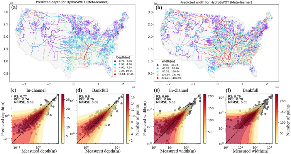
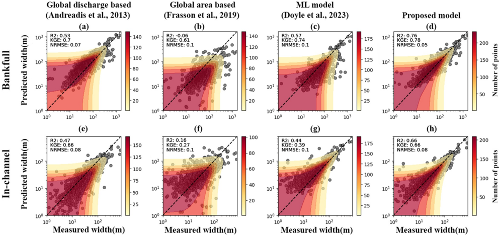
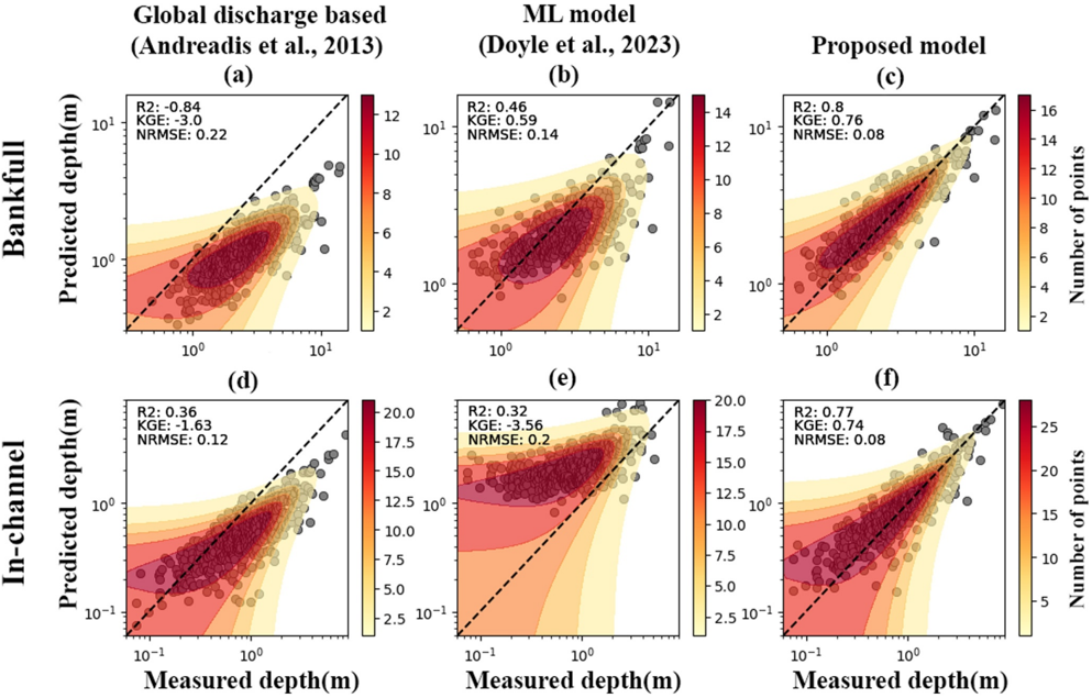
Knowledge of bankfull hydraulic geometry represents an essential requirement for various applications, including accurate flood prediction, hydrological routing, river behavior analysis, river management and engineering practices, water resource management, and beyond. Our work builds upon an extensive body of literature about estimating bankfull top‐width and depth at ungauged locations to enhance the understanding of observable factors that affect these parameters. Using more than 200,000 USGS Acoustic Doppler Current Profiler (ADCP) records, we developed a method employing machine learning (ML) using discharge estimates and landscape characteristics from sources, including the National Water Model (NWM), the National Hydrologic Geospatial Fabric network (NHGF), the EPA stream characteristic data set (StreamCat), and an array of satellite and reanalysis data products. Our method achieved log‐transformed R2 = 0.8 predicting bankfull depth (R2 = 0.77 for in‐channel conditions) and R2 = 0.76 predicting bankfull top‐width (R2 = 0.66 for in‐channel conditions) in the testing data set. The depth and width predictions showed lowest skill in mountainous and plateau regions. Our analysis demonstrates the benefit of data‐driven modeling in contrast to other global scaling‐based or regional statistical methods. In summary, our study illustrates how top‐width and depth can be better predicted using ML, reanalysis streamflow simulations, hydrographic networks, and summarized geospatial data.
Checked 2026-11-22 · 1 reference not checked yet
Overview
CoChat Summary
TL;DR
The paper develops machine-learning models to estimate bankfull and in-channel river top-width and depth across CONUS using >200,000 USGS ADCP records and predictors from the National Water Model, hydrographic networks, and landscape characteristics. The meta-learner ensemble achieved log-transformed R² = 0.80 for bankfull depth and 0.76 for bankfull top-width, outperforming global/regional equations and a prior ML approach.
Key findings
- Using >200,000 ADCP records from 10,081 USGS gauging locations, after filtering 4,229 of 6,226 initial sites were retained; testing-data log-transformed R² was 0.80 for bankfull depth (0.77 in-channel) and 0.76 for bankfull top-width (0.66 in-channel).
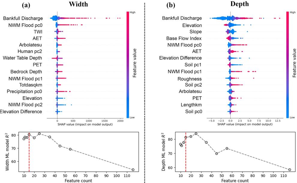
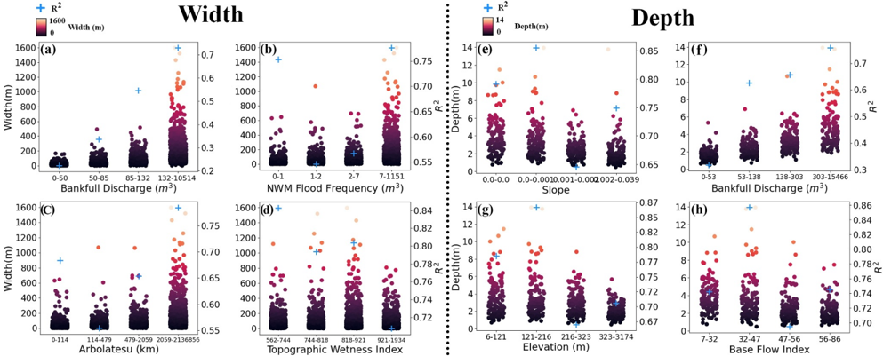
- The most influential predictor was bankfull/in-channel discharge, especially NWM-derived flood-frequency principal components; width was also influenced by cumulative upstream flowline length (Arbolatesu), topographic wetness index, and actual evapotranspiration, while depth was influenced by mean catchment elevation, channel slope, and base flow index.
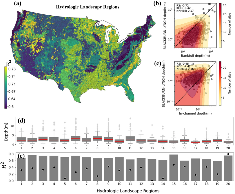
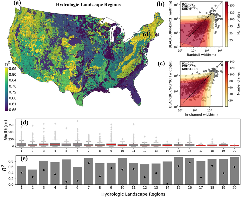
- Model skill varied by hydrologic landscape region: depth models performed better in plains and permeable-bedrock regions, while top-width models had lowest GOF in HLR 2 (very humid plains, R² ≈ 0.53) and highest in mountainous/plateau regions; the abstract reports lowest skill in mountainous and plateau regions.
- The ML models outperformed global drainage-area and discharge-based equations and the Doyle et al. (2023) ML method, with reduced scatter for mid-size and larger rivers but overprediction in smaller rivers.
Methods
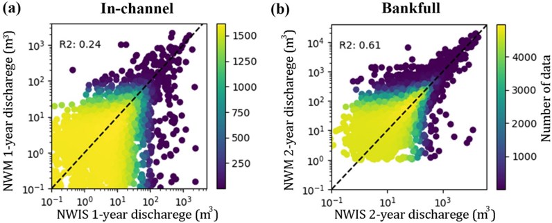
- Data: HYDRoSWOT ADCP observations (200,000+ measurements at 10,081 USGS gauges); profiles filtered to 2000–2015, depth <65 m, top-width <4 km, discharge agreement with NWIS, and no negative values; sites with inverse discharge–depth relationships or <5 profiles removed; AHG fits retained 4,229 of 6,226 sites with R² > 0.6. Bankfull was defined as 50% annual exceedance probability discharge and in-channel as 100%, computed via flood-frequency distributions (GEV, GP, LP3, generalized gamma; KS selection) and AHG relations.
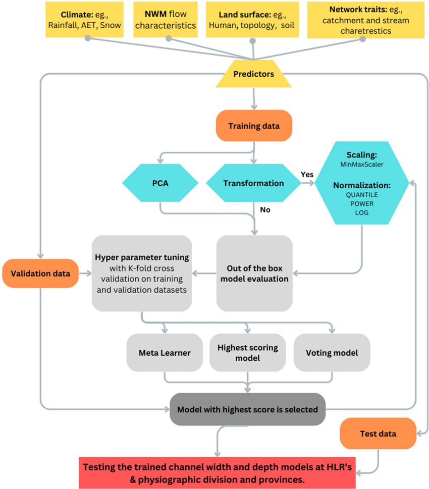
- Predictors: 116 initial variables from NWM v2.1 retrospective streamflow statistics (20%–0.1% annual exceedance probability and flow percentiles), NHGF hydrographic network, EPA StreamCat (58 watershed predictors), and climateR-aggregated soil/landscape/weather data (31 predictors); reduced to 15 features using SHAP and PCA/correlation clustering.
- Modeling: trained 40 ML models (neural network, tree-based, SVM), selected top 10 by R²/RMSE, fine-tuned with five-fold cross-validation and three repeats, then built meta-learner and voting ensembles; used 70% training, 10% validation, 20% testing; applied to approximately 2.7 million NHGF reaches across CONUS.
Limitations
- Paper states: training data are constrained to USGS sites, often with high banks, and may not represent entire reach geometry; no ADCP measurements in estuaries near river mouths make estimates unreliable there; estimates are unreliable near anthropogenically altered systems (dams, levees, irrigation canals, ponds); NWM’s diminished skill for 100% annual exceedance probability discharge impacts model GOF; reach-scale resolution overlooks braiding, incision, and aggradation; global scalability is constrained by reliance on NWM retrospective data and source-data biases/inconsistencies.
- Text makes evident: models underpredict top-width and depth for smaller rivers, and there is a shortage of large-river data in HYDRoSWOT; performance declines with lower discharge; top-width model GOF is lowest in HLR 2 plains, while depth model GOF is lower in mountainous/impermeable-bedrock regions.
Model-written summary. Check it against the paper before relying on it.
Integrity signals
Registry
Cites
Statistics
Figures









Verification
Claims the paper makes
0 Valid · 1 Not valid · 30 Not checked · 79 Own results and interpretations
A result the paper reports from its own data — it cites no other source for it, so there is none to check. The quote shows it is in the paper.
In the paper
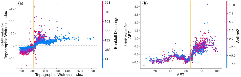
“In Figure 6a we saw a nonlinear relationship between bankfull discharge/TWI and channel dimensionality.”
§ Enhancing River Channel Dimension Estimation: A Machine Learning Approach Leveraging the National Water Model, Hydrographic Networks, and Landscape Characteristics > 4.1. Significance of Discharge in Channel Geometry Modeling
plainstates an association- Asserted: passes — The authors put it forward as true.
- Checkable: passes — It can be checked against evidence.
- Load-bearing: passes — The paper’s conclusions depend on it.
- Based: passes — The paper gives a reason why it holds.
- Rests on an assumption not shown here.
None of the sources cited for this claim have been checked yet.
In the paper
“It consistently (in width and depth under both flow conditions) demonstrates a strong positive correlation between higher magnitudes of the flood (Bankfull discharge and NWM Flood PCs), and broader, deeper channels, aligning with the established literature (Bjerklie et al., 2005;Brown & Pasternack, 2014;Wohl & Wilcox, 2005).”
§ Enhancing River Channel Dimension Estimation: A Machine Learning Approach Leveraging the National Water Model, Hydrographic Networks, and Landscape Characteristics > 4.1. Significance of Discharge in Channel Geometry Modeling
What the sources say
- Not checked yetcites Bjerklie et al., 2005 matched to “Estimating discharge in rivers using remotely sensed hydraulic information” (2005) source
- Not checked yetcites Brown & Pasternack, 2014 matched to “Hydrologic and topographic variability modulate channel change in mountain rivers” (2014) source
- Not checked yetcites Wohl & Wilcox, 2005 matched to “Channel geometry of mountain streams in New Zealand” (2005) source
boostedstates an association- Asserted: passes — The authors put it forward as true.
- Checkable: passes — It can be checked against evidence.
- Load-bearing: passes — The paper’s conclusions depend on it.
- Based: passes — The paper gives a reason why it holds.
- Rests on an assumption not shown here.
None of the sources cited for this claim have been checked yet.
In the paper
“The analysis reveals a pattern where channel depth models show higher GOF (R 2 ) in the prediction of bankfull depth predominantly in plains (HLR 1-8; Table S3 in Supporting Information S1) and regions with permeable bedrock (Carlier et al., 2018;Santhi et al., 2008).”
§ Enhancing River Channel Dimension Estimation: A Machine Learning Approach Leveraging the National Water Model, Hydrographic Networks, and Landscape Characteristics > 3.5. Performance in Hydrologic Landscape Regions
What the sources say
plainstates an association- Asserted: passes — The authors put it forward as true.
- Checkable: passes — It can be checked against evidence.
- Load-bearing: unclear — It is unclear whether the paper’s conclusions depend on it.
- Based: passes — The paper gives a reason why it holds.
- Rests on an assumption not shown here.
A result the paper states — it cites no source for it, so there is none to check. The quote shows it is in the paper.
In the paper
“Validation of the models across different regions indicated better performance in flatter regions and lower performance in steeper areas.”
§ Enhancing River Channel Dimension Estimation: A Machine Learning Approach Leveraging the National Water Model, Hydrographic Networks, and Landscape Characteristics > Abstract
hedgedstates an association- Asserted: passes — The authors put it forward as true.
- Checkable: passes — It can be checked against evidence.
- Load-bearing: unclear — It is unclear whether the paper’s conclusions depend on it.
- Based: passes — The paper gives a reason why it holds.
A result the paper reports from its own data — it cites no other source for it, so there is none to check. The quote shows it is in the paper.
In the paper
“All three variables exhibit a positive relationship with channel top-width, as indicated by SHAP importance values.”
§ Enhancing River Channel Dimension Estimation: A Machine Learning Approach Leveraging the National Water Model, Hydrographic Networks, and Landscape Characteristics > 3.2. Impactful Predictors
hedgedstates an association- Asserted: passes — The authors put it forward as true.
- Checkable: passes — It can be checked against evidence.
- Load-bearing: passes — The paper’s conclusions depend on it.
- Based: passes — The paper gives a reason why it holds.
- Rests on an assumption not shown here.
57 more claims
Create a free account to see all 110 claims and to verify the 39 references still open.
- Probably not a substantial claim. 22
- It may state two separate claims as one. 33
- The quote only partly states this claim. 3
Self-check
Percentages, sums and reported differences re-computed from the paper’s own numbers.
Each contradiction between two passages listed here was confirmed by an independent check.
Rated major: it would touch a result — a value a result rests on, reported and recomputed p-values on opposite sides of the significance level, two passages that conflict with no sign which is right, or a cited work retracted before this paper was published.
In the paper
§ Enhancing River Channel Dimension Estimation: A Machine Learning Approach Leveraging the National Water Model, Hydrographic Networks, and Landscape Characteristics > 3.1. In-Channel and Bankfull Model Performance
“In general, the models underpredict both top-width and depth as channel top-width and depth decrease (smaller rivers; scatter dots located on the right side of the 1:1 line in Figures 3 c-3f).”
§ Enhancing River Channel Dimension Estimation: A Machine Learning Approach Leveraging the National Water Model, Hydrographic Networks, and Landscape Characteristics > 3.6. Comparative Model Assessment
“Conversely, the ML methods tend to overpredict channel width in smaller rivers, as evidenced by the skewed tail in the plots.”
Rated major: it would touch a result — a value a result rests on, reported and recomputed p-values on opposite sides of the significance level, two passages that conflict with no sign which is right, or a cited work retracted before this paper was published.
In the paper
§ Enhancing River Channel Dimension Estimation: A Machine Learning Approach Leveraging the National Water Model, Hydrographic Networks, and Landscape Characteristics > Abstract
“The depth and width predictions showed lowest skill in mountainous and plateau regions.”
§ Enhancing River Channel Dimension Estimation: A Machine Learning Approach Leveraging the National Water Model, Hydrographic Networks, and Landscape Characteristics > 3.5. Performance in Hydrologic Landscape Regions
“The highest GOF based on R 2 are seen in all mountainous regions (HLR 15-20) and plateau regions (i.e., HLR 9-13; Vidon & Hill, 2004).”
Rated minor: it would not touch a result — a value no result rests on, a p-value that stays on the same side of the significance level, or a conflict that is clerical, resolved elsewhere in the paper, or outside its own findings.
In the paper
§ Enhancing River Channel Dimension Estimation: A Machine Learning Approach Leveraging the National Water Model, Hydrographic Networks, and Landscape Characteristics > 3.4. Hydrological Thresholds
“The soil PC2, which is a representative of clay and silt components (see Figure S3 in Supporting Information S1), is evenly scattered and shows no pattern.”
§ Enhancing River Channel Dimension Estimation: A Machine Learning Approach Leveraging the National Water Model, Hydrographic Networks, and Landscape Characteristics > 5. Conclusions
“Soil PC0 represents soil moisture, Soil PC1 represents % of clay and silt, and Soil PC2 represents % of sand.”
Rated minor: it would not touch a result — a value no result rests on, a p-value that stays on the same side of the significance level, or a conflict that is clerical, resolved elsewhere in the paper, or outside its own findings.
In the paper
§ Enhancing River Channel Dimension Estimation: A Machine Learning Approach Leveraging the National Water Model, Hydrographic Networks, and Landscape Characteristics > 4.3. Utility and Limitations
“This process helped reduce the number of model predictors from 116 to 15.”
§ Enhancing River Channel Dimension Estimation: A Machine Learning Approach Leveraging the National Water Model, Hydrographic Networks, and Landscape Characteristics > 4.3. Utility and Limitations
“Moreover, although our modeling strategy effectively reduced 112 variables into 15 components, the reliance on source data restricts the scalability of this approach to different geographical locations.”
Citations
Cites
A Unified Approach to Interpreting Model Predictions
Lundberg, S., & Lee, S.-I. (2017) · arXiv · doi:10.48550/arxiv.1705.07874 · Cited by 23,707
Advances in Neural Information Processing Systems 29
Teymur, O., Zygalakis, K., & Calderhead, B. (2016) · Cited by 13,887
The Global Land Data Assimilation System
Rodell, M., Houser, P. R., Jambor, U., Gottschalck, J., Mitchell, K., Meng, C.-J., Arsenault, K., Cosgrove, B., Radakovich, J., Bosilovich, M., et al. (2004) · Bulletin of the American Meteorological Society · doi:10.1175/bams-85-3-381 · Cited by 5,614
High-resolution mapping of global surface water and its long-term changes
Pekel, J.-F., Cottam, A., Gorelick, N., & Belward, A. S. (2016) · Nature · doi:10.1038/nature20584 · Cited by 5,513 · cited 1×
“Global Surface Water Explorer (Pekel et al., 2016) does not provide direct information about channel top-width, but its historical probability map of water occurrence can be used to distinguish riparian floodplain top-width, bankfull top-width, and in-channel top-width.”
Abatzoglou, J. T., Dobrowski, S. Z., Parks, S. A., & Hegewisch, K. C. (2018) · Scientific Data · doi:10.1038/sdata.2017.191 · Cited by 3,421
The hydraulic geometry of stream channels and some physiographic implications
Leopold, L. B., & Maddock, T. (1953) · Professional Paper · doi:10.3133/pp252 · Cited by 2,966
Learning from imbalanced data: open challenges and future directions
Krawczyk, B. (2016) · Progress in Artificial Intelligence · doi:10.1007/s13748-016-0094-0 · Cited by 2,459 · cited 1×
“This observation can be attributed to the skewed nature of hydrologic observations, with proportionately fewer data points collected from larger channels (in HYDRoSWOT), resulting in less training data for the machine learning model (Krawczyk, 2016).”
River channel patterns: Braided, meandering, and straight
Leopold, L. B., & Wolman, M. G. (1957) · USGS professional paper · doi:10.3133/pp282b · Cited by 2,294
Water in Environmental Planning
Clark, J., Dunne, T., & Leopold, L. B. (1980) · The Journal of Wildlife Management · doi:10.2307/3808399 · Cited by 2,251
Lehner, B., & Grill, G. (2013) · Hydrological Processes · doi:10.1002/hyp.9740 · Cited by 2,193
A classification of natural rivers
Rosgen, D. L. (1994) · CATENA · doi:10.1016/0341-8162(94)90001-9 · Cited by 1,713
A simple raster-based model for flood inundation simulation
Bates, P. D., & De Roo, A. P. J. (2000) · Journal of Hydrology · doi:10.1016/s0022-1694(00)00278-x · Cited by 1,460
MERIT Hydro: A High‐Resolution Global Hydrography Map Based on Latest Topography Dataset
Yamazaki, D., Ikeshima, D., Sosa, J., Bates, P. D., Allen, G. H., & Pavelsky, T. M. (2019) · Water Resources Research · doi:10.1029/2019wr024873 · Cited by 1,392
Shen, C. (2018) · Water Resources Research · doi:10.1029/2018wr022643 · Cited by 1,133
Wood, E. F., Roundy, J. K., Troy, T. J., van Beek, L. P. H., Bierkens, M. F. P., Blyth, E., de Roo, A., Döll, P., Ek, M., Famiglietti, J., et al. (2011) · Water Resources Research · doi:10.1029/2010wr010090 · Cited by 957
Williams, G. P. (1978) · Water Resources Research · doi:10.1029/wr014i006p01141 · Cited by 726
Mitigating the Multicollinearity Problem and Its Machine Learning Approach: A Review
Chan, J. Y.-L., Leow, S. M. H., Bea, K. T., Cheng, W. K., Phoong, S. W., Hong, Z.-W., & Chen, Y.-L. (2022) · Mathematics · doi:10.3390/math10081283 · Cited by 617 · cited 2×
“To address predictor collinearity, we perform correlation analysis following Chan et al. (2022).”
Determine the Number of Unknown Targets in Open World Based on Elbow Method
Liu, F., & Deng, Y. (2020) · IEEE Transactions on Fuzzy Systems · doi:10.1109/tfuzz.2020.2966182 · Cited by 393
Altenau, E. H., Pavelsky, T. M., Durand, M. T., Yang, X., Frasson, R. P. D. M., & Bendezu, L. (2021) · Water Resources Research · doi:10.1029/2021wr030054 · Cited by 317
Wolock, D. M., Winter, T. C., & McMahon, G. (2004) · Environmental Management · doi:10.1007/s00267-003-5077-9 · Cited by 301
Log-logistic flood frequency analysis
Ahmad, M. I., Sinclair, C. D., & Werritty, A. (1988) · Journal of Hydrology · doi:10.1016/0022-1694(88)90015-7 · Cited by 297
A simple global river bankfull width and depth database: Data and Analysis Note
Andreadis, K. M., Schumann, G. J.-P., & Pavelsky, T. (2013) · Water Resources Research · doi:10.1002/wrcr.20440 · Cited by 295
Hill, R. A., Weber, M. H., Leibowitz, S. G., Olsen, A. R., & Thornbrugh, D. J. (2016) · JAWRA Journal of the American Water Resources Association · doi:10.1111/1752-1688.12372 · Cited by 288
Estimating discharge in rivers using remotely sensed hydraulic information
Bjerklie, D. M., Moller, D., Smith, L. C., & Dingman, S. L. (2005) · Journal of Hydrology · doi:10.1016/j.jhydrol.2004.11.022 · Cited by 283
Ob' river discharge from TOPEX/Poseidon satellite altimetry (1992–2002)
Kouraev, A. V., Zakharova, E. A., Samain, O., Mognard, N. M., & Cazenave, A. (2004) · Remote Sensing of Environment · doi:10.1016/j.rse.2004.07.007 · Cited by 239
Regional estimation of base flow for the conterminous United States by hydrologic landscape regions
Santhi, C., Allen, P. M., Muttiah, R. S., Arnold, J. G., & Tuppad, P. (2008) · Journal of Hydrology · doi:10.1016/j.jhydrol.2007.12.018 · Cited by 236
RivWidth: A Software Tool for the Calculation of River Widths From Remotely Sensed Imagery
Pavelsky, T. M., & Smith, L. C. (2008) · IEEE Geoscience and Remote Sensing Letters · doi:10.1109/lgrs.2007.908305 · Cited by 231
A first large-scale flood inundation forecasting model
Schumann, G. J.-P., Neal, J. C., Voisin, N., Andreadis, K. M., Pappenberger, F., Phanthuwongpakdee, N., Hall, A. C., & Bates, P. D. (2013) · Water Resources Research · doi:10.1002/wrcr.20521 · Cited by 224
Chaney, N. W., Minasny, B., Herman, J. D., Nauman, T. W., Brungard, C. W., Morgan, C. L. S., McBratney, A. B., Wood, E. F., & Yimam, Y. (2019) · Water Resources Research · doi:10.1029/2018wr022797 · Cited by 209
Frasson, R. P. D. M., Pavelsky, T. M., Fonstad, M. A., Durand, M. T., Allen, G. H., Schumann, G., Lion, C., Beighley, R. E., & Yang, X. (2019) · Geophysical Research Letters · doi:10.1029/2019gl082027 · Cited by 204
Assessing the potential global extent of SWOT river discharge observations
Pavelsky, T. M., Durand, M. T., Andreadis, K. M., Beighley, R. E., Paiva, R. C. D., Allen, G. H., & Miller, Z. F. (2014) · Journal of Hydrology · doi:10.1016/j.jhydrol.2014.08.044 · Cited by 201
McCabe, G. J., & Wolock, D. M. (2011) · Water Resources Research · doi:10.1029/2011wr010630 · Cited by 195
Landscape controls on the hydrology of stream riparian zones
Vidon, P. G. F., & Hill, A. R. (2004) · Journal of Hydrology · doi:10.1016/j.jhydrol.2004.01.005 · Cited by 188
Effects of in-channel sand excavation on the hydrology of the Pearl River Delta, China
Luo, X.-L., Zeng, E. Y., Ji, R.-Y., & Wang, C.-P. (2007) · Journal of Hydrology · doi:10.1016/j.jhydrol.2007.06.019 · Cited by 181
Accelerating advances in continental domain hydrologic modeling
Archfield, S. A., Clark, M., Arheimer, B., Hay, L. E., McMillan, H., Kiang, J. E., Seibert, J., Hakala, K., Bock, A., Wagener, T., et al. (2015) · Water Resources Research · doi:10.1002/2015wr017498 · Cited by 177
Schwenk, J., Khandelwal, A., Fratkin, M., Kumar, V., & Foufoula‐Georgiou, E. (2017) · Earth and Space Science · doi:10.1002/2016ea000196 · Cited by 175
Yamazaki, D., Oki, T., & Kanae, S. (2009) · Hydrology and Earth System Sciences · doi:10.5194/hess-13-2241-2009 · Cited by 167
GeoFlood: Large‐Scale Flood Inundation Mapping Based on High‐Resolution Terrain Analysis
Zheng, X., Maidment, D. R., Tarboton, D. G., Liu, Y. Y., & Passalacqua, P. (2018) · Water Resources Research · doi:10.1029/2018wr023457 · Cited by 163
Yang, X., Pavelsky, T. M., Allen, G. H., & Donchyts, G. (2020) · IEEE Geoscience and Remote Sensing Letters · doi:10.1109/lgrs.2019.2920225 · Cited by 156 · cited 1×
“…the extraction of continental-scale river centerline and top-124 width for North American rivers using Landsat imagery, and more recently, the RivWidthCloud software using cloud computing (Google Earth Engine) to extract channel top-widths from a vast archive of Landsat imagery (Yang et al., 2019).”
Johnson, J. M., Munasinghe, D., Eyelade, D., & Cohen, S. (2019) · Natural Hazards and Earth System Sciences · doi:10.5194/nhess-19-2405-2019 · Cited by 152
Self-citationA global network for operational flood risk reduction
Alfieri, L., Cohen, S., Galantowicz, J. F., Schumann, G. J.-P., Trigg, M. A., Zsótér, E., Prudhomme, C., Kruczkiewicz, A., de Perez, E. C., Flamig, Z. L., et al. (2018) · Environmental Science & Policy · doi:10.1016/j.envsci.2018.03.014 · Cited by 150
RivaMap: An automated river analysis and mapping engine
Isikdogan, F., Bovik, A., & Passalacqua, P. (2017) · Remote Sensing of Environment · doi:10.1016/j.rse.2017.03.044 · Cited by 149
The SWOT Mission and Its Capabilities for Land Hydrology
Biancamaria, S., Lettenmaier, D. P., & Pavelsky, T. M. (2016) · Space Sciences Series of ISSI · doi:10.1007/978-3-319-32449-4_6 · Cited by 138
Calibration of satellite measurements of river discharge using a global hydrology model
Robert Brakenridge, G., Cohen, S., Kettner, A. J., De Groeve, T., Nghiem, S. V., Syvitski, J. P. M., & Fekete, B. M. (2012) · Journal of Hydrology · doi:10.1016/j.jhydrol.2012.09.035 · Cited by 137
Cruz-Cárdenas, G., López–Mata, L., Villaseñor, J. L., & Ortíz, E. (2015) · Revista Mexicana de Biodiversidad · doi:10.7550/rmb.36723 · Cited by 134
Bieger, K., Rathjens, H., Allen, P. M., & Arnold, J. G. (2015) · JAWRA Journal of the American Water Resources Association · doi:10.1111/jawr.12282 · Cited by 130
Estimating River Channel Bathymetry in Large Scale Flood Inundation Models
Neal, J. C., Hawker, L., Savage, J. T. S., Durand, M., Bates, P., & Sampson, C. (2021) · Water Resources Research · doi:10.1029/2020wr028301 · Cited by 128
Durand, M., Rodriguez, E., Alsdorf, D. E., & Trigg, M. (2010) · IEEE Journal of Selected Topics in Applied Earth Observations and Remote Sensing · doi:10.1109/jstars.2009.2033453 · Cited by 127
Channel geometry of mountain streams in New Zealand
Wohl, E. E., & Wilcox, A. (2005) · Journal of Hydrology · doi:10.1016/j.jhydrol.2004.06.006 · Cited by 127
Automated extraction of meandering river morphodynamics from multitemporal remotely sensed data
Monegaglia, F., Zolezzi, G., Güneralp, İ., Henshaw, A. J., & Tubino, M. (2018) · Environmental Modelling & Software · doi:10.1016/j.envsoft.2018.03.028 · Cited by 122
Sharma, S. K., Gajbhiye, S., & Tignath, S. (2014) · Applied Water Science · doi:10.1007/s13201-014-0170-1 · Cited by 104
Cohen, S., Raney, A., Munasinghe, D., Loftis, J. D., Molthan, A., Bell, J., Rogers, L., Galantowicz, J., Brakenridge, G. R., Kettner, A. J., et al. (2019) · Natural Hazards and Earth System Sciences · doi:10.5194/nhess-19-2053-2019 · Cited by 104
Woodyer, K. D. (1968) · Journal of Hydrology · doi:10.1016/0022-1694(68)90155-8 · Cited by 97
Dingman, S. L. (2009) · doi:10.1093/oso/9780195172867.001.0001 · Cited by 97
Variability and uncertainty in reach bankfull hydraulic geometry
Harman, C., Stewardson, M., & DeRose, R. (2008) · Journal of Hydrology · doi:10.1016/j.jhydrol.2007.11.015 · Cited by 94
Deep Learning Estimation of Daily Ground‐Level NO 2 Concentrations From Remote Sensing Data
Ghahremanloo, M., Lops, Y., Choi, Y., & Yeganeh, B. (2021) · Journal of Geophysical Research: Atmospheres · doi:10.1029/2021jd034925 · Cited by 94
Characterization of the spatial variability of channel morphology
Moody, J. A., & Troutman, B. M. (2002) · Earth Surface Processes and Landforms · doi:10.1002/esp.403 · Cited by 93
Bjerklie, D. M. (2007) · Journal of Hydrology · doi:10.1016/j.jhydrol.2007.04.011 · Cited by 91
Geology controls streamflow dynamics
Carlier, C., Wirth, S. B., Cochand, F., Hunkeler, D., & Brunner, P. (2018) · Journal of Hydrology · doi:10.1016/j.jhydrol.2018.08.069 · Cited by 89
Zakharova, E., Nielsen, K., Kamenev, G., & Kouraev, A. (2020) · Journal of Hydrology · doi:10.1016/j.jhydrol.2020.124561 · Cited by 88
Global Estimates of Reach‐Level Bankfull River Width Leveraging Big Data Geospatial Analysis
Lin, P., Pan, M., Allen, G. H., de Frasson, R. P., Zeng, Z., Yamazaki, D., & Wood, E. F. (2020) · Geophysical Research Letters · doi:10.1029/2019gl086405 · Cited by 83
Bindas, T., Tsai, W., Liu, J., Rahmani, F., Feng, D., Bian, Y., Lawson, K., & Shen, C. (2024) · Water Resources Research · doi:10.1029/2023wr035337 · Cited by 82
Flood frequency estimation and uncertainty in arid/semi-arid regions
Metzger, A., Marra, F., Smith, J. A., & Morin, E. (2020) · Journal of Hydrology · doi:10.1016/j.jhydrol.2020.125254 · Cited by 61
Getirana, A. C. V., Boone, A., Yamazaki, D., & Mognard, N. (2013) · Water Resources Research · doi:10.1002/wrcr.20077 · Cited by 59
Sichangi, A., Wang, L., & Hu, Z. (2018) · Remote Sensing · doi:10.3390/rs10091385 · Cited by 59
Hydrologic and topographic variability modulate channel change in mountain rivers
Brown, R. A., & Pasternack, G. B. (2014) · Journal of Hydrology · doi:10.1016/j.jhydrol.2013.12.048 · Cited by 48
Johnson, J. M., Fang, S., Sankarasubramanian, A., Rad, A. M., Kindl da Cunha, L., Jennings, K. S., Clarke, K. C., Mazrooei, A., & Yeghiazarian, L. (2023) · Journal of Geophysical Research: Atmospheres · doi:10.1029/2023jd038534 · Cited by 45
Self-citationIntercontinental predictions of river hydraulic geometry from catchment physical characteristics
Morel, M., Booker, D. J., Gob, F., & Lamouroux, N. (2019) · Journal of Hydrology · doi:10.1016/j.jhydrol.2019.124292 · Cited by 43
World Environmental and Water Resources Congress 2009 : Great Rivers
Starrett, S. (2009) · Cited by 42
Improved Bankfull Discharge Prediction Using 2‐Year Recurrence‐Period Discharge 1
Wilkerson, G. V. (2008) · JAWRA Journal of the American Water Resources Association · doi:10.1111/j.1752-1688.2007.00151.x · Cited by 35
Deriving principal channel metrics from bank and long-profile geometry with the R package cmgo
Golly, A., & Turowski, J. M. (2017) · Earth Surface Dynamics · doi:10.5194/esurf-5-557-2017 · Cited by 34
Bjerklie, D. M., Fulton, J. W., Dingman, S. L., Canova, M. G., Minear, J. T., & Moramarco, T. (2020) · Water Resources Research · doi:10.1029/2019wr025986 · Cited by 34
Canova, M. G., Fulton, J. W., & Bjerklie, D. M. (2016) · USGS DOI Tool Production Environment · doi:10.5066/f7d798h6 · Cited by 32
Featured Collection Introduction: National Water Model
Cohen, S., Praskievicz, S., & Maidment, D. R. (2018) · JAWRA Journal of the American Water Resources Association · doi:10.1111/1752-1688.12664 · Cited by 30
River Extraction under Bankfull Discharge Conditions Based on Sentinel-2 Imagery and DEM Data
Li, D., Wang, G., Qin, C., & Wu, B. (2021) · Remote Sensing · doi:10.3390/rs13142650 · Cited by 27
Durand, M., Chen, C., de Moraes Frasson, R. P., Pavelsky, T. M., Williams, B., Yang, X., & Fore, A. (2020) · Remote Sensing of Environment · doi:10.1016/j.rse.2020.111883 · Cited by 26
Johnson, J. M., Blodgett, D. L., Clarke, K., & Pollak, J. (2023) · Scientific Data · doi:10.1038/s41597-023-02316-7 · Cited by 26
Self-citationHan, M., Mai, J., Tolson, B. A., Craig, J. R., Gaborit, É., Liu, H., & Lee, K. (2020) · Canadian Water Resources Journal / Revue canadienne des ressources hydriques · doi:10.1080/07011784.2020.1772116 · Cited by 23
Flood frequency analysis using generalized distributions and entropy-based model selection method
Zhang, H., Chen, L., & Singh, V. P. (2020) · Journal of Hydrology · doi:10.1016/j.jhydrol.2020.125610 · Cited by 22
Booker, D. J., & Dunbar, M. J. (2008) · Hydrological Processes · doi:10.1002/hyp.7007 · Cited by 21
Emery, C., Biancamaria, S., Boone, A. A., Garambois, P., Ricci, S., Rochoux, M. C., & Decharme, B. (2016) · Journal of Hydrometeorology · doi:10.1175/jhm-d-16-0050.1 · Cited by 21
Retrieving river baseflow from SWOT spaceborne mission
Baratelli, F., Flipo, N., Rivière, A., & Biancamaria, S. (2018) · Remote Sensing of Environment · doi:10.1016/j.rse.2018.09.013 · Cited by 21
Biswal, S., Sahoo, B., Jha, M. K., & Bhuyan, M. K. (2023) · Journal of Hydrology · doi:10.1016/j.jhydrol.2023.129951 · Cited by 21
Geomorphological significance of at‐many‐stations hydraulic geometry
Shen, C., Wang, S., & Liu, X. (2016) · Geophysical Research Letters · doi:10.1002/2016gl068364 · Cited by 19
Blackburn‐Lynch, W., Agouridis, C. T., & Barton, C. D. (2017) · JAWRA Journal of the American Water Resources Association · doi:10.1111/1752-1688.12540 · Cited by 19
The Role of Realistic Channel Geometry Representation in Hydrological Model Predictions
Brackins, J. T., Moragoda, N., Rahman, A., Cohen, S., & Lowry, C. S. (2020) · JAWRA Journal of the American Water Resources Association · doi:10.1111/1752-1688.12865 · Cited by 18
Blodgett, D. L., Johnson, J. M., & Bock, A. (2023) · Environmental Modelling & Software · doi:10.1016/j.envsoft.2023.105726 · Cited by 18
Self-citationErikson, C. M., Renshaw, C. E., & Magilligan, F. J. (2023) · Geomorphology · doi:10.1016/j.geomorph.2023.108998 · Cited by 15
Fang, S., Johnson, J. M., Yeghiazarian, L., & Sankarasubramanian, A. (2024) · Water Resources Research · doi:10.1029/2023wr034557 · Cited by 15
Self-citationEvaluation of a new observationally based channel parameterization for the National Water Model
Heldmyer, A., Livneh, B., McCreight, J., Read, L., Kasprzyk, J., & Minear, T. (2022) · Hydrology and Earth System Sciences · doi:10.5194/hess-26-6121-2022 · Cited by 11
Doyle, J. M., Hill, R. A., Leibowitz, S. G., & Ebersole, J. L. (2023) · JAWRA Journal of the American Water Resources Association · doi:10.1111/1752-1688.13116 · Cited by 8
Using HEC-RAS Hydraulic Design Functions for Geomorphic Channel Design and Analysis
Shelley, J. E., & Parr, A. D. (2009) · World Environmental and Water Resources Congress (EWRI) · doi:10.1061/41036(342)374 · Cited by 6
Köppen, M., & Franke, K. (2000) · Soft Computing in Industrial Applications · doi:10.1007/978-1-4471-0509-1_4 · Cited by 4
Johnson, J. M., Afshari, S., & Rad, A. M. (2024) · The Journal of Open Source Software · doi:10.21105/joss.06145 · Cited by 2
Self-citationRad, A. M. (2024) · HydroShare Resources · doi:10.4211/hs.d147fcf554a54b2aaa4f146f85da0e03 · Cited by 1
lynker-spatial/RiverShapeML: CONUS ML width and depth
Rad-NOAA, A. M., & MikeJohnson-NOAA (2024) · Zenodo (CERN European Organization for Nuclear Research) · doi:10.5281/zenodo.13715358 · Cited by 1
lynker-spatial/RiverShapeML: CONUS ML width and depth
Rad-NOAA, A. M., & MikeJohnson-NOAA (2024) · Zenodo · doi:10.5281/zenodo.13715359
Bankfull Discharge for Kansas Natural Alluvial Channel Design
Shelley, J., Young, C. B., & McEnroe, B. (2009) · World Environmental and Water Resources Congress 2009 · doi:10.1061/41036(342)364
Research works printed but not linked: 4
- Bock, A. R., Blodgett, D. L., Johnson, J. M., Santiago, M., & Wieczorek, M. E. (2022). Provisional: National hydrologic geospatial fabric reference and derived hydrofabrics (p. 2022120390).
- Emery, C. M., Biancamaria, S., Boone, A., Garambois, P.-A., Ricci, S., Rochoux, M. C., & Decharme, B. (2016). Temporal variance-based sensitivity analysis of the river-routing component of the large-scale hydrological model ISBA-TRIP: Application on the Amazon Basin. Journal of Hydrometeorology, 17(12), 3007-3027. https://doi.org/10.1175/JHM-D-16-0050. · doi:10.1175/jhm-d-16-0050
- Haan, C. T., Johnson, H. P., & Brakensiek, D. L. (1982). Hydrologic modeling of small watersheds. https://doi.org/10.5555/19851999449 · doi:10.5555/19851999449
- Köppen, M. (2000). The curse of dimensionality. In 5th Online World Conference on Soft Computing in Industrial Applications (WSC5) (Vol. 1, pp. 4-8). Retrieved from https://www.class-specific.com/csf/papers/hidim.pdf
Cited by
Ogden, F. L., Jennings, K. S., Clark, E. P., Coon, E. T., Cosgrove, B. A., da Cunha, L. K., Farthing, M. W., Flowers, T., Frame, J., Frazier, N., et al. (2026) · JAWRA Journal of the American Water Resources Association · doi:10.1111/1752-1688.70089 · Cited by 12
Self-citationPatel, A., Halgren, J., Wills, Z., Frazier, N., Lee, B., Cunningham, J., Laser, J., Karimiziarani, M., Patel, T., Romero, G., et al. (2025) · Environmental Modelling & Software · doi:10.1016/j.envsoft.2025.106666 · Cited by 10
Self-citationBaruah, A., Zarrabi, R., Cohen, S., Johnson, J. M., & McDermott, R. (2025) · Scientific Reports · doi:10.1038/s41598-025-27881-2 · Cited by 8
Self-citationChen, Y., Cohen, S., Baruah, A., Devi, D., Dhital, S., Tian, D., & Munasinghe, D. (2025) · Scientific Data · doi:10.1038/s41597-025-05941-6 · Cited by 8
High‐Resolution Channel Geometry Reveals Contrasting Styles of Gravel River Adjustment
Kostynick, R. P., Phillips, C. B., & Masteller, C. C. (2026) · Geophysical Research Letters · doi:10.1029/2025gl118412 · Cited by 4
Metadata
- Authors
- Modaresi Rad, A., Johnson, J. M., Ghahremani, Z., Coll, J., & Frazier, N.
- Affiliations
- Lynker Fort Collins CO USA
- National Oceanic and Atmospheric Administration (US)
- Corresponding author
- Johnson, J. Michael
- Venue
- Journal of Geophysical Research: Machine Learning and Computation
- Publisher
- American Geophysical Union (AGU)
- Published
- 2024-11-25
- Volume
- 1
- Issue
- 4
- ISSN
- 2993-5210 (ISSN-L)
- OpenAlex
- W4404699222
- Semantic Scholar
- dd01d84abfc695cff27825fef089e22e219238e9
- Cited by
- 11
- References
- 94
- Citations by year
- 2026: 7 · 2025: 4
- FWCI
- 2.26
- Type
- journal article
- Language
- en
- Open access
- gold
- doi.org
- Licence
- Locations
- Journal of Geophysical Research Machine Learning and Computation (publishedVersion, cc-by)
- NOAA Institutional Repository (submittedVersion, cc-by)
- DOAJ (DOAJ: Directory of Open Access Journals) (submittedVersion, cc-by-sa)
- Funders
- National Oceanic and Atmospheric Administration
- Topics
- Physical Sciences › Earth and Planetary Sciences › Earth-Surface Processes › Hydrology and Sediment Transport Processes
- Physical Sciences › Environmental Science › Water Science and Technology › Hydrology and Watershed Management Studies
- Physical Sciences › Environmental Science › Environmental Engineering › Hydrological Forecasting Using AI
- Keywords
- bankfull depth, ungauged rivers, National Water Model, river networks, landscape elements, acoustic Doppler current profiler, discharge estimation, flood forecasting
About these checks
Registry, retraction, Cites and statistics results are computed, not judged, with one exception: a printed reference that no index lists is read once by a model before it counts as a citation error. Claims are extracted by a model and kept only when their quote appears verbatim in the text; each cited source is then checked, with a model’s help, for whether it says what the claim relies on. Those verdicts can be wrong — read the claim’s quote and the cited source before relying on one.
A language model drew the claims from the paper on 2026-11-18, under version 3 of the claim definition (model deepseek-v4.1-flash, prompt extract-v3).
A second model labelled each claim on 2026-11-18 (model jev-1.13-20260917, definition revision gold-guideline-v0.2).
Statistics and arithmetic are recomputed, not judged.
Confidence bands are shown only for fields calibrated on our annotated test set. None is calibrated yet, so no band is shown.
What counts as a claim ›How we measure confidence ›How we check this ›
Are you an author, or do you see a problem with this page? Request a review
Data sources
Bibliographic data: Semantic Scholar, OpenAlex, Crossref.
Contains information from the Semantic Scholar Academic Graph Datasets, made available under the ODC Attribution License (ODC-BY 1.0).
Semantic Scholar’s data is described in: Kinney, R., et al. (2023). The Semantic Scholar Open Data Platform. arXiv:2301.10140.
