

A Sentinel-2 Multiyear, Multicountry Benchmark Dataset for Crop Classification and Segmentation With Deep Learning
Open accessThe DOI matches its Crossref record; 56 of the 58 references it cites were found in a registry or an index, and 2 are not checked yet.
Abstract
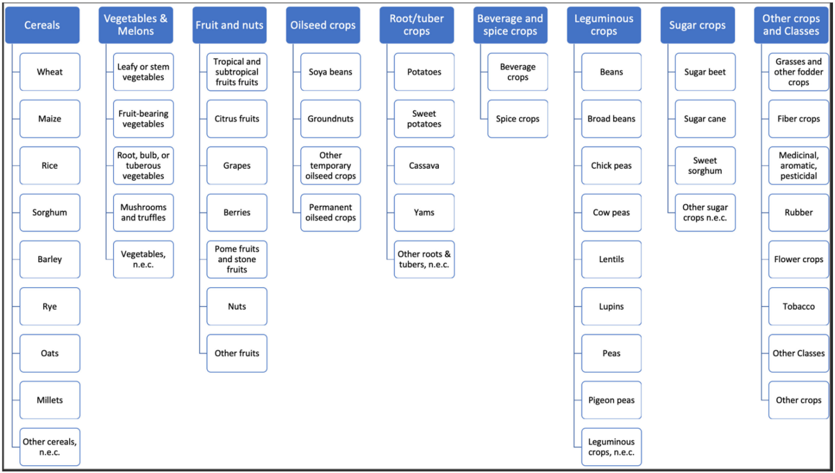
In this work, we introduce Sen4AgriNet, a Sentinel-2-based time series multicountry benchmark dataset, tailored for agricultural monitoring applications with machine and deep learning. Sen4AgriNet dataset is annotated from farmer declarations collected via the land parcel identification system (LPIS) for harmonizing country-wide labels. These declarations have only recently been made available as open data, allowing for the first time the labeling of satellite imagery from ground truth data. We proceed to propose and standardize a new crop type taxonomy across Europe that addresses common agriculture policy (CAP) needs, based on the Food and Agriculture Organization (FAO) indicative crop classification scheme. Sen4AgriNet is the only multicountry, multiyear dataset that includes all spectral information. It is constructed to cover the period 2016–2020 for Catalonia and France, while it can be extended to include additional countries. Currently, it contains 42.5 million parcels, which makes it significantly larger than other available archives. We extract two subdatasets to highlight its value for diverse deep learning applications—the object aggregated dataset (OAD) and the patches assembled dataset (PAD). OAD capitalizes zonal statistics of each parcel, thus creating a powerful label-to-features instance for classification algorithms. On the other hand, PAD structure generalizes the classification problem to parcel extraction and semantic segmentation and labeling. The PAD and OAD are examined under three different scenarios to showcase and model the effects of spatial and temporal variability across different years and different countries.1
Overview
The claims and statistics of this paper haven’t been checked yet.
Free: it reads the open-access text and checks the first 5 claims that cite a source we can check. Create a free account to check every claim.
Integrity signals
Registry
Cites
Statistics
Figures








Verification
Claims the paper makes
The claims and statistics of this paper haven’t been checked yet.
Free: it reads the open-access text and checks the first 5 claims that cite a source we can check. Create a free account to check every claim.
Claims other papers make about this one
Each is checked against this paper’s own text: does it say what the citing paper says it does?
The cited source says what the claim attributes to it.
In the citing paper
“As discussed by Sykas et al. (2022), the classification generalization capacity to different years and geographic locations remains a great challenge in RS, and domain adaptation strategies should be adopted to bridge the inherent gaps.”
From Benchmarking and scaling of deep learning models for land cover image classification (2023) · cites this paper as Sykas et al. (2022)
Self-check
Percentages, sums and reported differences re-computed from the paper’s own numbers.
The self-check needs the paper’s full text.
Citations
Cites
Deep Residual Learning for Image Recognition
He, K., Zhang, X., Ren, S., & Sun, J. (2016) · 2016 IEEE Conference on Computer Vision and Pattern Recognition (CVPR) · doi:10.1109/cvpr.2016.90 · Cited by 235,474
Vaswani, A., Shazeer, N., Parmar, N., Uszkoreit, J., Jones, L., Gomez, A. N., Kaiser, L., & Polosukhin, I. (2017) · arXiv · doi:10.48550/arxiv.1706.03762 · Cited by 120,404
Hochreiter, S., & Schmidhuber, J. (1997) · Neural Computation · doi:10.1162/neco.1997.9.8.1735 · Cited by 102,318
U-Net: Convolutional Networks for Biomedical Image Segmentation
Ronneberger, O., Fischer, P., & Brox, T. (2015) · Lecture notes in computer science · doi:10.1007/978-3-319-24574-4_28 · Cited by 99,404
Learning Phrase Representations using RNN Encoder–Decoder for Statistical Machine Translation
Cho, K., van Merrienboer, B., Gulcehre, C., Bahdanau, D., Bougares, F., Schwenk, H., & Bengio, Y. (2014) · Proceedings of the 2014 Conference on Empirical Methods in Natural Language Processing (EMNLP) · doi:10.3115/v1/d14-1179 · Cited by 25,545
Unpaired image-to-image translation using cycle-consistent adversarial networks
Zhu, J.-Y., Park, T., Isola, P., & Efros, A. A. (2017) · 2017 IEEE International Conference on Computer Vision (ICCV) · doi:10.1109/iccv.2017.244 · Cited by 23,602
Advances in Neural Information Processing Systems 19
(2007) · The MIT Press eBooks · doi:10.52202/085713 · Cited by 15,539
Advances in Neural Information Processing Systems 29
Teymur, O., Zygalakis, K., & Calderhead, B. (2016) · Cited by 13,887
UMAP: Uniform Manifold Approximation and Projection
McInnes, L., Healy, J., Saul, N., & Großberger, L. (2018) · Journal of Open Source Software · doi:10.21105/joss.00861 · Cited by 9,826 · cited 1×
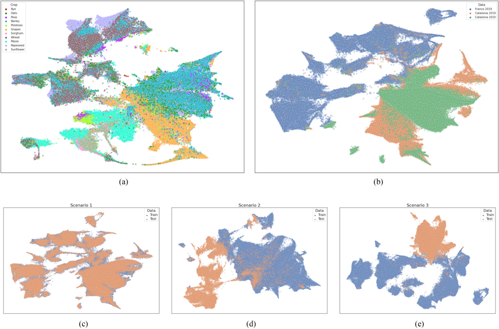
“In order to fortify this observation, different UMAP [62] visualizations are provided in Fig.”
MethodConvolutional LSTM Network: A Machine Learning Approach for Precipitation Nowcasting
Shi, X., Chen, Z., Wang, H., Yeung, D.-Y., Wong, W.-K., & Woo, W.-C. (2015) · arXiv · doi:10.48550/arxiv.1506.04214 · Cited by 7,709
Research works printed but not linked: 5
- Ji, 2018, 3D convolutional neural networks for crop classification with multi-temporal remote sensing images, 10
- 10.3390/iigi7040129 · doi:10.3390/iigi7040129
- Tong, 2020, Land-cover classification with high-resolution remote sensing images using transferable deep models, 237, 111322
- 2005, A System of Integrated Agricultural Censuses and Surveys. Volume 1, World Programme for the Census of Agriculture 2010
- Sykas, 2021, Sen4agrinet: A harmonized multi-country, multi-temporal benchmark dataset for agricultural earth observation machine learning applications, 10.1109/igarss47720.2021.9553603 · DOI
Cited by
Deep Learning for Satellite Image Time-Series Analysis: A review
Miller, L., Pelletier, C., & Webb, G. I. (2024) · IEEE Geoscience and Remote Sensing Magazine · doi:10.1109/mgrs.2024.3393010 · Cited by 155
Maraveas, C., Konar, D., Michopoulos, D. K., Arvanitis, K. G., & Peppas, K. P. (2024) · Computers and Electronics in Agriculture · doi:10.1016/j.compag.2024.108680 · Cited by 115
Crop mapping using supervised machine learning and deep learning: a systematic literature review
Machichi, M. A., Mansouri, L. E., Imani, Y., Bourja, O., Lahlou, O., Zennayi, Y., Bourzeix, F., Houmma, I. H., & Hadria, R. (2023) · International Journal of Remote Sensing · doi:10.1080/01431161.2023.2205984 · Cited by 104
Benchmarking and scaling of deep learning models for land cover image classification
Papoutsis, I., Bountos, N. I., Zavras, A., Michail, D., & Tryfonopoulos, C. (2023) · ISPRS Journal of Photogrammetry and Remote Sensing · doi:10.1016/j.isprsjprs.2022.11.012 · Cited by 86
“As discussed by Sykas et al. (2022), the classification generalisation capacity to different years and geographic locations remains a great challenge in RS, and domain adaptation strategies should be adopted to bridge the inherent gaps.”
BackgroundSelf-citationDeep Learning Models for the Classification of Crops in Aerial Imagery: A Review
Teixeira, I., Morais, R., Sousa, J. J., & Cunha, A. M. T. D. S. (2023) · Agriculture · doi:10.3390/agriculture13050965 · Cited by 76
Metadata
- Authors
- Sykas, D., Sdraka, M., Zografakis, D., & Papoutsis, I.
- Affiliations
- Institute of Astronomy, Astrophysics, Space Applications & Remote Sensing, National Observatory of Athens, Athens, Greece
- National Observatory of Athens (GR)
- Venue
- IEEE Journal of Selected Topics in Applied Earth Observations and Remote Sensing
- Published
- 2022
- Volume
- 15
- Pages
- 3323-3339
- ISSN
- 1939-1404 (ISSN-L)
- 2151-1535
- OpenAlex
- W4225728415
- Cited by
- 59
- References
- 56
- Citations by year
- 2026: 17 · 2025: 8 · 2024: 15 · 2023: 13 · 2022: 6
- FWCI
- 5.60
- Type
- journal article
- Language
- en
- Open access
- gold
- doi.org
- Locations
- IEEE Journal of Selected Topics in Applied Earth Observations and Remote Sensing (publishedVersion, cc-by)
- arXiv (Cornell University) (submittedVersion)
- DOAJ (DOAJ: Directory of Open Access Journals) (submittedVersion)
- arXiv (Cornell University)
- Funders
- H2020 LEIT Space (101004188)
- Topics
- Physical Sciences › Environmental Science › Ecology › Remote Sensing in Agriculture
- Physical Sciences › Computer Science › Computer Vision and Pattern Recognition › Remote-Sensing Image Classification
- Life Sciences › Agricultural and Biological Sciences › Plant Science › Smart Agriculture and AI
- Keywords
- Sentinel-2, crop classification, crop segmentation, agricultural monitoring, Land Parcel Identification System, Common Agricultural Policy, satellite time series, semantic segmentation, zonal statistics, Catalonia, France
About these checks
Registry, retraction, Cites and statistics results are computed, not judged, with one exception: a printed reference that no index lists is read once by a model before it counts as a citation error. Claims are extracted by a model and kept only when their quote appears verbatim in the text; each cited source is then checked, with a model’s help, for whether it says what the claim relies on. Those verdicts can be wrong — read the claim’s quote and the cited source before relying on one.
Statistics and arithmetic are recomputed, not judged.
Confidence bands are shown only for fields calibrated on our annotated test set. None is calibrated yet, so no band is shown.
What counts as a claim ›How we measure confidence ›How we check this ›
Are you an author, or do you see a problem with this page? Request a review
How to cite
Cite CoChat for the checks on this page, and the paper for its own findings.
- This page
- CoChat. (2026). Citation check: A Sentinel-2 Multiyear, Multicountry Benchmark Dataset for Crop Classification and Segmentation With Deep Learning. https://app.cochat.ai/papers/10.1109/jstars.2022.3164771
- The paper
- Sykas, D., Sdraka, M., Zografakis, D., & Papoutsis, I. (2022). A Sentinel-2 Multiyear, Multicountry Benchmark Dataset for Crop Classification and Segmentation With Deep Learning. IEEE Journal of Selected Topics in Applied Earth Observations and Remote Sensing. https://doi.org/10.1109/jstars.2022.3164771
Data sources
Bibliographic data: Semantic Scholar, OpenAlex, Crossref.
Contains information from the Semantic Scholar Academic Graph Datasets, made available under the ODC Attribution License (ODC-BY 1.0).
Semantic Scholar’s data is described in: Kinney, R., et al. (2023). The Semantic Scholar Open Data Platform. arXiv:2301.10140.
