

The DOI matches its Crossref record.
Volcanic stratigraphy and age model of the Kimama deep borehole (Project Hotspot): Evidence for 5.8 million years of continuous basalt volcanism, central Snake River Plain, Idaho
Overview
The claims and statistics of this paper haven’t been checked yet.
Run the check — free, no account needed. It reads the open-access text and checks the sources it cites.
Integrity signals
Registry
Cites
Statistics
Figures
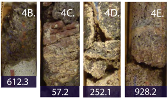
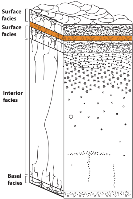

Verification
Claims the paper makes
The claims and statistics of this paper haven’t been checked yet.
Run the check — free, no account needed. It reads the open-access text and checks the sources it cites.
Claims other papers make about this one
Each is checked against this paper’s own text: does it say what the citing paper says it does?
In the citing paper
“Criteria for distinction of flow-lobes in that core are described by the authors (et seq., pgs 3-8) and are like those employed by us, allowing a consistent lobe delineation.”
From Thickness Characteristics of Pāhoehoe Lavas in the Deccan Province, Western Ghats, India, and in Continental Flood Basalt Provinces Elsewhere (2021) · cites this paper as Potter et al., 2019
In the citing paper
“it is clear (Figure 8B inset) that the modal size of lobes is considerably smaller than in the CRB”
From Thickness Characteristics of Pāhoehoe Lavas in the Deccan Province, Western Ghats, India, and in Continental Flood Basalt Provinces Elsewhere (2021) · cites this paper as Potter et al. (2019)
In the citing paper
“this thick pile of basalt, which accumulated over ∼ 6 Ma, is almost all HP in nature”
From Thickness Characteristics of Pāhoehoe Lavas in the Deccan Province, Western Ghats, India, and in Continental Flood Basalt Provinces Elsewhere (2021) · cites this paper as Potter et al. (2019)
Self-check
Percentages, sums and reported differences re-computed from the paper’s own numbers.
The self-check needs the paper’s full text.
Citations
Cites
No references could be resolved yet.
Research works printed but not linked: 62
- Anders, 2009, Neogene tephra correlations in eastern Idaho and Wyoming Yellowstone for hotspot-related volcanism and tectonic activity, Geological Society of America Bulletin, 121, 837, 10.1130/B26300.1 · DOI
- Armstrong, 1975, K-Ar dating, Quaternary and Neogene rocks of the Snake River Plain, Idaho, American Journal of Science, 275, 225, 10.2475/ajs.275.3.225 · DOI
- Baksi, 2007, A quantitative tool for detecting alteration in undisturbed rocks and minerals—I: Water, chemical weathering, and atmospheric argon, 285, 10.1130/2007.2430(15) · DOI
- Beranek, 2006, Miocene to Holocene landscape evolution of the western Snake River Plain region, Idaho: Using the SHRIMP detrital zircon provenance record to track eastward migration of the Yellowstone hotspot, Geological Society of America Bulletin, 118, 1027, 10.1130/B25896.1 · DOI
- Bonnichsen, 2002, Late Miocene, Pliocene, and Pleistocene geology of southwestern Idaho with emphasis on basalts in the Bruneau-Jarbidge, Twin Falls, and western Snake River Plain regions: Tectonic and magmatic evolution of the Snake River Plain volcanic province, Idaho Geological Survey Bulletin, 30, 233
- Bonnichsen, 2008, Miocene silicic volcanism in southwestern Idaho: Geochronology, geochemistry, and evolution of the central Snake River Plain, Bulletin of Volcanology, 70, 315, 10.1007/s00445-007-0141-6 · DOI
- Champion, 1988, Evidence for a new geomagnetic reversal from lava flows in Idaho: Discussion of short polarity reversals in the Brunhes and Late Matuyama Polarity Chrons, Journal of Geophysical Research, 93, 11,677, 10.1029/JB093iB10p11667 · DOI
- Champion, 2002, Accumulation and subsidence of late Pleistocene basaltic lava flows of the eastern Snake River Plain, Idaho, 175
- Chitwood, 1994, Inflated basaltic lava—Examples of processes and landforms from central and southeast Oregon, Oregon Geology, 56, 11
- Drew, 2013, Crustal-scale recycling in caldera complexes and rift zones along the Yellowstone hotspot track: O and Hf isotopic evidence in diverse zircons from voluminous rhyolites of the Picabo volcanic field, Idaho, Earth and Planetary Science Letters, 381, 63, 10.1016/j.epsl.2013.08.007 · DOI
- Duncan, 1994, Radiometric dating of young MORB using the 40Ar-39Ar incremental heating method, Geophysical Research Letters, 21, 1927, 10.1029/94GL01375 · DOI
- Duncan, 1997, The timing and duration of the Karoo igneous event, southern Gondwana, Journal of Geophysical Research, 102, 18,127, 10.1029/97JB00972 · DOI
- Goff, 1996, Vesicle cylinders in vapor-differentiated basalt flows, Journal of Volcanology and Geothermal Research, 71, 167, 10.1016/0377-0273(95)00073-9 · DOI
- Greeley, 1977, Basaltic “plains” volcanism, 23
- Greeley, 1982, The Snake River Plain, Idaho: Representative of a new category of volcanism, Journal of Geophysical Research, 87, 2705, 10.1029/JB087iB04p02705 · DOI
- Hackett, 2004, Volcanic hazards of the Idaho National Engineering and Environmental Laboratory, southeast Idaho, 461
- Hanan, 2008, Yellowstone plume–continental lithosphere interaction beneath the Snake River Plain, Geology, 36, 51, 10.1130/G23935A.1 · DOI
- Hodges, 2009, The Pliocene Lost River found to west: Detrital zircon evidence of drainage disruption along a subsiding hotspot track, Journal of Volcanology and Geothermal Research, 188, 237, 10.1016/j.jvolgeores.2009.08.019 · DOI
- Huang, 2015, The Yellowstone magmatic system from the mantle plume to the upper crust, Science, 348, 773, 10.1126/science.aaa5648 · DOI
- Hughes, 1999, Mafic volcanism and environmental geology of the eastern Snake River Plain, Idaho, 143
- Hughes, 2002, Evolution of Quaternary tholeiitic basalt eruptive centers on the eastern Snake River Plain, Idaho, 363
- Jean, 2013, Geochemical and paleomagnetic variations in basalts from the Wendell Regional Aquifer Systems Analysis (RASA) drill core: Evidence for magma recharge and assimilation–fractional crystallization from the central Snake River Plain, Idaho: Geosphere, 9, 1319
- Jean, 2014, Yellowstone hotspot–continental lithosphere interaction, Earth and Planetary Science Letters, 389, 119, 10.1016/j.epsl.2013.12.012 · DOI
- Jean, 2018, Caldera life-cycles of the Yellowstone Hotspot Track: Death and rebirth of the Heise Caldera, Journal of Petrology, 59, 1643, 10.1093/petrology/egy074 · DOI
- Kessler, 2017, Geology and in situ stress of the MH-2 borehole, Idaho, USA: Insights into western Snake River Plain structure from geothermal exploration drilling, Lithosphere, 9, 476, 10.1130/L609.1 · DOI
- Koppers, 2002, ArArCALC—software for 40Ar/39Ar age calculations, Computers & Geosciences, 28, 605, 10.1016/S0098-3004(01)00095-4 · DOI
- Koppers, 2000, Dating crystalline groundmass separates of altered Cretaceous seamount basalts by the 40Ar/39Ar incremental heating technique, Chemical Geology, 166, 139, 10.1016/S0009-2541(99)00188-6 · DOI
- Kuntz, 1992, An overview of basaltic volcanism of the eastern Snake River Plain, Idaho, 227, 10.1130/MEM179-p227 · DOI
- Kuntz, 1986, Contrasting magma types and steady-state, volume-predictable, basaltic volcanism along the Great Rift, Idaho, Geological Society of America Bulletin, 97, 579, 10.1130/0016-7606(1986)97<579:CMTASV>2.0.CO;2 · DOI
- Kuntz, 2002, Tension cracks, eruptive fissures, dikes, and faults related to late Pleistocene–Holocene basaltic volcanism and implications for the distribution of hydraulic conductivity in the eastern Snake River Plain, in Idaho, 111, 10.1130/0-8137-2353-1.111 · DOI
- Kuntz, M.A., Champion, D.E., Turrin, B.R., Gans, P.B., Covington, H.R., and Van Sistine, D.P., 2018, Geologic Map of the North Half of the Lake Walcott 30′ × 60′ Quadrangle, Idaho, U.S. Geologic Survey Scientific Investigations Report 3405, pamphlet 25 p., scale 1:100,000, https://doi.org/10.3133/sim3405. · DOI
- Lachmar, 2017, Effect of an 860-m thick, cold, freshwater aquifer on geothermal potential along the axis of the eastern Snake River Plain, Idaho, Geothermal Energy, 5, 28, 10.1186/s40517-017-0086-8 · DOI
- Leeman, 1982, Evolved and hybrid lavas from the Snake River Plain, Idaho, 181
- McFadden, 1982, Analysis of palaeomagnetic inclination data, Geophysical Journal International, 69, 307, 10.1111/j.1365-246X.1982.tb04950.x · DOI
- Morgan, 1972, Plate motions and deep mantle convection, 7, 10.1130/MEM132-p7 · DOI
- Morse, 2002, Genesis of alteration of Quaternary basalts within a portion of the eastern Snake River Plain aquifer, 213, 10.1130/0-8137-2353-1.213 · DOI
- Nier, 1950, A redetermination of the relative abundances of the isotopes of carbon, nitrogen, oxygen, argon, and potassium, Physical Review, 77, 789, 10.1103/PhysRev.77.789 · DOI
- Peng, 1998, Crustal Velocity Structure Across the eastern Snake River Plain and Yellowstone Swell, Journal of Geophysical Research, 103, 7171, 10.1029/97JB03615 · DOI
- Pierce, 1992, The track of the Yellowstone Hotspot: Volcanism, faulting, and uplift, 1, 10.1130/MEM179-p1 · DOI
- Pierce, 2009, Is the track of the Yellowstone hotspot driven by a deep mantle plume?—Review of volcanism, faulting, and uplift in light of new data, Journal of Volcanology and Geothermal Research, 188, 1, 10.1016/j.jvolgeores.2009.07.009 · DOI
- Potter, 2014, The Kimama Core: A 6.4 Ma Record of Volcanism, Sedimentation, and Magma Petrogenesis on the Axial Volcanic High, Snake River Plain, ID [Ph.D. dissertation], 161
- Potter, 2018, Evidence for cyclical fractional crystallization, recharge, and assimilation in basalts of the Kimama Drill Core, central Snake River Plain, Idaho: 5.5-million-years of petrogenesis in a mid-crustal sill complex, Frontiers of Earth Science, 6, 17
- Putirka, 2009, Magma evolution and ascent at the Craters of the Moon and neighboring volcanic fields, southern Idaho, USA: Implications for the evolution of polygenetic and monogenetic volcanic fields, Journal of Petrology, 50, 1639, 10.1093/petrology/egp045 · DOI
- Renne, 1998, Intercalibration of standards, absolute ages and uncertainties in 40Ar/39Ar dating: Chemical Geology, Isotope Geoscience Section, 145, 117
- Sant, 2013, Geothermal alteration of basaltic core from the Snake River Plain, Idaho: [M.S. thesis], 113
- Sant, 2011, Project Hotspot: Preliminary analysis of secondary mineralization in basaltic core, central Snake River Plain, Geothermal Resources Council Transactions, 35, 987
- Self, 1998, The importance of pahoehoe, Annual Review of Earth and Planetary Sciences, 26, 81, 10.1146/annurev.earth.26.1.81 · DOI
- Shervais, 2008, Lithospheric topography, tilted plumes, and the track of the Snake River–Yellowstone hot spot, Tectonics, 27, 10.1029/2007TC002181 · DOI
- Shervais, 2006, Layered mafic sill complex beneath the eastern Snake River Plain: Evidence from cyclic geochemical variations in basalt, Geology, 34, 365, 10.1130/G22226.1 · DOI
- Shervais, 2011, Project Hotspot—The Snake River Scientific Drilling Project, Geothermal Resources Council Transactions, 35, 995
- Shervais, 2012, Hotspot: The Snake River geothermal drilling project—Initial report, Geothermal Resources Council Transactions, 36, 767
- Shervais, 2013, First Results from HOTSPOT: The Snake River Plain Scientific Drilling Project, Idaho, U.S.A: Scientific Drilling, 15, 36
- Shervais, 2014, Drilling into the track of the Yellowstone hot spot, Eos [Transactions, American Geophysical Union], 95, 85, 10.1002/2014EO100001 · DOI
- Smith, 1994, The Yellowstone hotspot, Journal of Volcanology and Geothermal Research, 61, 121, 10.1016/0377-0273(94)90002-7 · DOI
- Smith, 2009, Geodynamics of the Yellowstone hotspot and mantle plume: Seismic and GPS imaging, kinematics, and mantle flow, Journal of Volcanology and Geothermal Research, 188, 26, 10.1016/j.jvolgeores.2009.08.020 · DOI
- Smith, 1967, Segregation vesicles in basaltic lava, American Journal of Science, 265, 696, 10.2475/ajs.265.8.696 · DOI
- Steiger, 1977, Subcommission on geochronology: Convention on the use of decay constants in geo- and cosmochronology, Earth and Planetary Science Letters, 36, 359, 10.1016/0012-821X(77)90060-7 · DOI
- Waite, 2006, VP and VS structure of the Yellowstone hot spot from teleseismic tomography: Evidence for an upper mantle plume: Journal of Geophysical Research, Solid Earth, 111, 21
- Walker, 1971, Compound and simple lava flows and flood basalts, Bulletin Volcanologique, 35, 579, 10.1007/BF02596829 · DOI · Paper page
- Walker, 1991, Structure, and origin by injection of lava under surface crust, of tumuli, “lava rises”, “lava-rise pits” and “lava-inflation clefts” in Hawaii, Bulletin of Volcanology, 53, 546, 10.1007/BF00298155 · DOI
- Walker, 1993, Basaltic-volcano systems, 3
- Welhan, 2002, Morphology of inflated pahoehoe lavas and spatial architecture of their porous and permeable zones, eastern Snake River Plain, Idaho, 135, 10.1130/0-8137-2353-1.135 · DOI
Cited by
Self, S., Mittal, T., & Jay, A. E. (2021) · Frontiers in Earth Science · doi:10.3389/feart.2020.630604 · Cited by 33
Metadata
- Authors
- Potter, K. E., Champion, D. E., Duncan, R. A., & Shervais, J. W.
- Affiliations
- Department of Geology, Utah State University, Logan, Utah 84321, USA
- Volcano Science Center, U.S. Geological Survey, 345 Middlefield Road, Menlo Park, California 94025, USA
- College of Earth, Ocean, and Atmospheric Sciences, Oregon State University, Corvallis, Oregon 97331, USA
- Venue
- Geosphere
- Publisher
- Geological Society of America
- Published
- 2019-03-19
- Volume
- 15
- Issue
- 3
- Pages
- 736-758
- ISSN
- 1553-040X
- Cited by
- 12
- References
- 0
- Language
- en
About these checks
Registry, retraction, Cites and statistics results are computed, not judged, with one exception: a printed reference that no index lists is read once by a model before it counts as a citation error. Claims are extracted by a model and kept only when their quote appears verbatim in the text; each cited source is then checked, with a model’s help, for whether it says what the claim relies on. Those verdicts can be wrong — read the claim’s quote and the cited source before relying on one.
Statistics and arithmetic are recomputed, not judged.
Confidence bands are shown only for fields calibrated on our annotated test set. None is calibrated yet, so no band is shown.
What counts as a claim ›How we measure confidence ›How we check this ›
Are you an author, or do you see a problem with this page? Request a review
How to cite
Cite CoChat for the checks on this page, and the paper for its own findings.
- This page
- CoChat. (2026). Citation check: Volcanic stratigraphy and age model of the Kimama deep borehole (Project Hotspot): Evidence for 5.8 million years of continuous basalt volcanism, central Snake River Plain, Idaho. https://app.cochat.ai/papers/10.1130/ges01679.1
- The paper
- Potter, K. E., Champion, D. E., Duncan, R. A., & Shervais, J. W. (2019). Volcanic stratigraphy and age model of the Kimama deep borehole (Project Hotspot): Evidence for 5.8 million years of continuous basalt volcanism, central Snake River Plain, Idaho. Geosphere. https://doi.org/10.1130/ges01679.1
