

The DOI matches its Crossref record; 104 of the 104 references it cites were found in a registry or an index.
Dynamics of Green Sahara Periods and Their Role in Hominin Evolution
Open accessAbstract
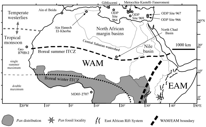
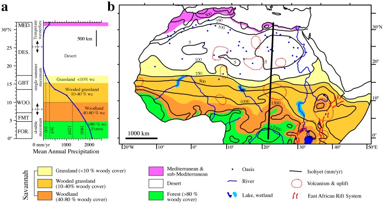
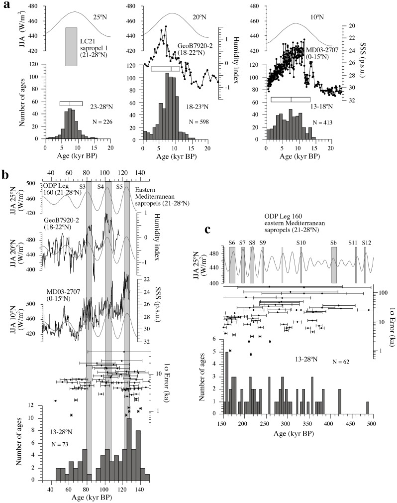
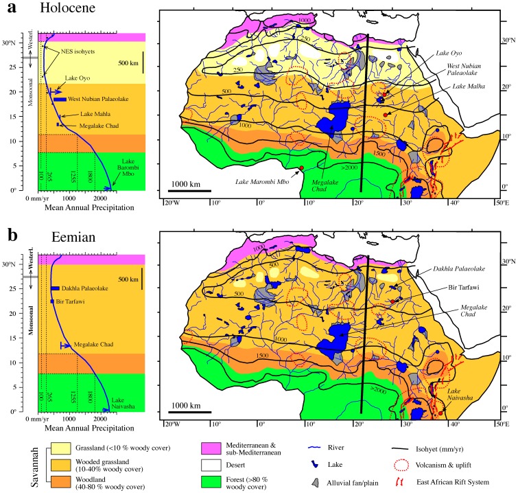
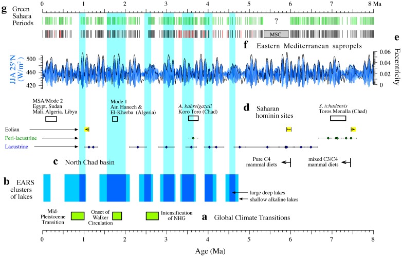
Astronomically forced insolation changes have driven monsoon dynamics and recurrent humid episodes in North Africa, resulting in green Sahara Periods (GSPs) with savannah expansion throughout most of the desert. Despite their potential for expanding the area of prime hominin habitats and favouring out-of-Africa dispersals, GSPs have not been incorporated into the narrative of hominin evolution due to poor knowledge of their timing, dynamics and landscape composition at evolutionary timescales. We present a compilation of continental and marine paleoenvironmental records from within and around North Africa, which enables identification of over 230 GSPs within the last 8 million years. By combining the main climatological determinants of woody cover in tropical Africa with paleoenvironmental and paleoclimatic data for representative (Holocene and Eemian) GSPs, we estimate precipitation regimes and habitat distributions during GSPs. Their chronology is consistent with the ages of Saharan archeological and fossil hominin sites. Each GSP took 2-3 kyr to develop, peaked over 4-8 kyr, biogeographically connected the African tropics to African and Eurasian mid latitudes, and ended within 2-3 kyr, which resulted in rapid habitat fragmentation. We argue that the well-dated succession of GSPs presented here may have played an important role in migration and evolution of hominins.
Overview
The claims and statistics of this paper haven’t been checked yet.
Run the check — free, no account needed. It reads the open-access text and checks the sources it cites.
Integrity signals
Registry
Cites
Statistics
Figures
Verification
Claims the paper makes
The claims and statistics of this paper haven’t been checked yet.
Run the check — free, no account needed. It reads the open-access text and checks the sources it cites.
Claims other papers make about this one
Each is checked against this paper’s own text: does it say what the citing paper says it does?
The cited source says what the claim attributes to it.
In the citing paper
“Other hypotheses further emphasize the ability of natural landmarks such as deserts and oceans to form barriers that isolate populations (Larrasoaña et al., 2013).”
From Dynamics of niche construction in adaptable populations evolving in diverse environments (2023) · cites this paper as Larrasoaña et al., 2013
Self-check
Percentages, sums and reported differences re-computed from the paper’s own numbers.
The self-check needs the paper’s full text.
Citations
Cites
A long-term numerical solution for the insolation quantities of the Earth
Laskar, J., Robutel, P., Joutel, F., Gastineau, M., Correia, A. C. M., & Levrard, B. (2004) · Astronomy and Astrophysics · doi:10.1051/0004-6361:20041335 · Cited by 4,541
Hydrological changes in the African tropics since the Last Glacial Maximum
Gasse, F. (2000) · Quaternary Science Reviews · doi:10.1016/s0277-3791(99)00061-x · Cited by 1,368
White, F. (1983) · Natural Resources Research · Cited by 1,275
Climate-Controlled Holocene Occupation in the Sahara: Motor of Africa's Evolution
Kuper, R., & Kröpelin, S. (2006) · Science · doi:10.1126/science.1130989 · Cited by 958
Monsoon variability over the past 150,000 years
Prell, W. L., & Kutzbach, J. E. (1987) · Journal of Geophysical Research Atmospheres · doi:10.1029/jd092id07p08411 · Cited by 900
Climate-driven ecosystem succession in the Sahara: the past 6000 years
Kröpelin, S., Verschuren, D., Lézine, A.-M., Eggermont, H., Cocquyt, C., Francus, P., Cazet, J.-P., Fagot, M., Rumes, B., Russell, J. M., et al. (2008) · Science · doi:10.1126/science.1154913 · Cited by 679
African monsoons, an immediate climate response to orbital insolation
Rossignol‐Strick, M. (1983) · Nature · doi:10.1038/304046a0 · Cited by 666
Rapid coupling between ice volume and polar temperature over the past 150,000 years
Grant, K., Rohling, E. J., Bar‐Matthews, M., Ayalon, A., Medina‐Elizalde, M., Ramsey, C. B., Satow, C., & Roberts, A. P. (2012) · Nature · doi:10.1038/nature11593 · Cited by 643
Self-citationWoody cover and hominin environments in the past 6 million years
Cerling, T. E., Wynn, J. G., Andanje, S. A., Bird, M. I., Korir, D. K., Levin, N. E., Mace, W., Macharia, A. N., Quade, J., & Remien, C. H. (2011) · Nature · doi:10.1038/nature10306 · Cited by 638
Ancient watercourses and biogeography of the Sahara explain the peopling of the desert
Drake, N., Blench, R. M., Armitage, S. J., Bristow, C. S., & White, K. H. (2010) · Proceedings of the National Academy of Sciences · doi:10.1073/pnas.1012231108 · Cited by 528
Research works printed but not linked: 7
- N Petit-Maire, 1986, Palaeoclimates in the Sahara of Mali. A multidisciplinary study, Episodes, 9, 7
- C Causse, 1988, The last Pleistocene humid phase in the Western Sahara, dated to about 80–100 ka, C R Acad Sci Paris, 306, 1459
- Wendorf F, Schild R, Close AE, Schwarcz HP, Miller GH, <etal>et al</etal>.. (1994) A chronology for the middle and late Pleistocene wet episodes in the Eastern Sahara. In: Bar-Yosef O, Kra R, eds. Egypt During the Last Interglacial: the Middle Paleolithic of Bir Tarwafi and Bir Sahara East. New York: Plenum Press. 147–168.
- N Petit Maire, 1994, A last interglacial palaeolake in the hyperarid Sahara of Mali, 23°N, C R Acad Sci Paris, 319, 805
- Kleindienst MR, Schwarcz HP, Nicoll K, Churcher CS, Frizano J, <etal>et al</etal>.. (2008) Water in the desert: first report on uranium-series dating of Caton-Thompson’s and Gardner’s “classic” Pleistocene sequence at Refuf Pass, Kharga Oasis. In: Wiseman MF, ed. Oasis Papers II: Proceedings of the Second Dakhleh Oasis Project Research Seminar. Oxford: Oxbow Books. 25–54.
- MAE Hamdam, 2000, Quaternary travertines of Wadis Abu Had-Dib Area, eastern desert, Egypt: palaeoenvironment through field, sedimentology, age and isotopic study, Sedimentology of Egypt, 8, 49
- PM McHugh, 1988, Acheulian sites along the “radar rivers”, J Field Archaeol, 15, 361
Cited by
Sorted by citations
Mediterranean climate and oceanography, and the periodic development of anoxic events (sapropels)
Rohling, E. J., Marino, G., & Grant, K. (2015) · Earth-Science Reviews · doi:10.1016/j.earscirev.2015.01.008 · Cited by 547
Self-citationOtto‐Bliesner, B. L., Braconnot, P., Harrison, S. P., Lunt, D. J., Abe‐Ouchi, A., Albani, S., Bartlein, P. J., Capron, É., Carlson, A. E., Dutton, A. L., et al. (2017) · Geoscientific model development · doi:10.5194/gmd-10-3979-2017 · Cited by 403
Late Pleistocene climate drivers of early human migration
Timmermann, A., & Friedrich, T. (2016) · Nature · doi:10.1038/nature19365 · Cited by 345
Early–Middle Pleistocene transitions: Linking terrestrial and marine realms
Head, M. J., & Gibbard, P. L. (2015) · Quaternary International · doi:10.1016/j.quaint.2015.09.042 · Cited by 316
Aridification of the Sahara desert caused by Tethys Sea shrinkage during the Late Miocene
Zhang, Z., Ramstein, G., Schuster, M., Li, C., Contoux, C., & Yan, Q. Y. (2014) · Nature · doi:10.1038/nature13705 · Cited by 302
Metadata
- Authors
- Larrasoaña, J. C., Roberts, A. P., & Rohling, E. J.
- Affiliations
- Australian National University (AU)
- Corresponding author
- Larrasoaña, Juan C.
- Venue
- PLoS ONE
- Publisher
- Public Library of Science (PLoS)
- Published
- 2013-10-16
- Volume
- 8
- Issue
- 10
- Pages
- e76514
- ISSN
- 1932-6203 (ISSN-L)
- PMC
- PMC3797788
- OpenAlex
- W2018031694
- Cited by
- 334
- References
- 104
- Citations by year
- 2026: 17 · 2025: 29 · 2024: 35 · 2023: 43 · 2022: 40 · 2021: 38 · 2020: 31 · 2019: 20 · 2018: 22 · 2017: 21 · 2016: 14 · 2015: 16 · 2014: 6 · 2013: 2
- FWCI
- 8.25
- Type
- journal article
- Language
- en
- Open access
- gold
- doi.org
- Locations
- PLoS ONE (publishedVersion, cc-by)
- Europe PMC (PubMed Central) (publishedVersion, cc-by)
- PubMed Central (publishedVersion, cc-by)
- PubMed (publishedVersion)
- ePrints Soton (University of Southampton) (acceptedVersion)
- ANU Open Research (Australian National University) (submittedVersion, other-oa)
- Institutional Archive of Ifremer (French Research Institute for Exploitation of the Sea) (submittedVersion, other-oa)
- DOAJ (DOAJ: Directory of Open Access Journals) (submittedVersion, cc-by-sa)
- Zaguan (Universidad de Zaragoza) (submittedVersion, cc-by)
- Funders
- Natural Environment Research Council (NE/I009906/1, NE/H004424/1, NE/E01531X/1)
- Topics
- Physical Sciences › Earth and Planetary Sciences › Atmospheric Science › Geology and Paleoclimatology Research
- Social Sciences › Anthropology › Pleistocene-Era Hominins and Archaeology
- Life Sciences › Agricultural and Biological Sciences › Soil Science › Soil and Environmental Studies
- Keywords
- hominin evolution, monsoon dynamics, insolation forcing, savannah expansion, paleoenvironmental records, paleoclimate, woody cover, precipitation regime, habitat fragmentation, dispersal out of Africa, Holocene, Last Interglacial, North Africa, paleoecology
- MeSH terms
- Africa, Northern, Animals, Climate, Biological Evolution, Rain, Time Factors, Tropical Climate, Hominidae, Ecosystem, Phylogeography
About these checks
Registry, retraction, Cites and statistics results are computed, not judged, with one exception: a printed reference that no index lists is read once by a model before it counts as a citation error. Claims are extracted by a model and kept only when their quote appears verbatim in the text; each cited source is then checked, with a model’s help, for whether it says what the claim relies on. Those verdicts can be wrong — read the claim’s quote and the cited source before relying on one.
Statistics and arithmetic are recomputed, not judged.
Confidence bands are shown only for fields calibrated on our annotated test set. None is calibrated yet, so no band is shown.
What counts as a claim ›How we measure confidence ›How we check this ›
Are you an author, or do you see a problem with this page? Request a review
