

The DOI matches its Crossref record; none of the 25 sources its claims cite is checked for support yet.
Un ensayo metodológico de caminería y geografía históricas en el valle de Lamasón (Cantabria)
Open accessAbstract
A methodological essay on historic road and geography in the valley of Lamasón (Cantabria) After reviewing the different approaches that historical road studies have developed in Spain, a new integrative methodology is presented between the historical road and the historical geography of the landscape carried out in an investigation in the valley of Lamasón (Cantabria). Methodology characterized by going from the whole (road network) to the parts (roads), to develop a regressive approach from front to back and to combine documentary and archaeological sources, and which has allowed to rebuild the previous roadway to the current and study of all its vestiges. The results are considered very positive within the studies of historical road, but in those of historical geography of the landscape was not reached completely to the objectives marked in the beginning. Nevertheless, it is still considered the most suitable method for the study of the historic road networks and their interrelation with the rest of the elements of the landscape.
Overview
AI snapshot
Written from the paper’s full text.
TL;DR
This methodological essay tests Éric Vion’s regressive road-network method in the Lamasón valley (Cantabria), combining archival and archaeological fieldwork to move from the present network to historical paths. It reconstructs mainly a 17th–19th-century road network and road typologies, but source and archaeological limits prevent reaching medieval or earlier networks and deeply linking roads to the wider historical landscape.
Key findings
- The method allowed reconstructing the historical road network as a whole and descending to individual paths, including local/agrarian ones, not only supralocal routes; most road structures were reconstructed.
- The dominant historical road type was a cut/sunken cross-section with rough cobbled pavement and small stone retaining walls; widths ranged from “metro escaso” to “dos metros largos,” allowing pack traffic and local carts, with no clear typological difference between main and local paths.
- Documentary work concentrated on the 17th–19th centuries, especially 18th-century notarial protocols from the Archivo Histórico Provincial de Cantabria (legs. 2.348, 2.405, 2.418–2.424, 2.488–2.494, 2.509), yielding many road mentions and toponyms.
- In historical geography of landscape, results were “más confusos y discutibles”: the study could not go beyond the 17th–19th-century network or deeply interrelate roads with settlement, terrazgo, and monte.
Methods
- Design: methodological essay applying Vion’s regressive/systematic method—start from the current road network, strip modern roads/tracks, and work backward to old paths—while combining documentary, oral, field, and archaeological evidence.
- Study area: Lamasón, western Cantabria, a closed medium-mountain valley of about 7,000 ha.
- Analysis: documentary sources (notarial protocols, 19th-century cartography, geographic dictionaries, Real Chancillería de Valladolid lawsuits/plans), field survey of surviving segments/elements, and coding similar to the Swiss IVS with three digits (main route, branch, segment); examined sections, widths, pavements, and associated features for traffic/function/chronotypology.
Limitations
- Paper states: documentary scarcity below the 17th century prevented reaching medieval and earlier networks; unlike Liébana, there were no cartularies, diplomatic collections, or monastic apeos rich in road/toponym references.
- Paper states: archaeological limits—no network-scale anomalies due to lack of earlier-network information and mountainous relief that forced routes; at path scale, scarce datable materials left dating to chronotypologies, weak for marginal/local paths; a requested archaeological prospection with material movement at Venta de los Lobos was denied by the Consejería de Cultura de Cantabria.
- Paper states/evident: the method is complex and difficult; Vion himself acknowledged difficulties, and attempts to combine scales and periods often complicated results, with the transition from network to concrete paths rarely completed. The article itself says it is reduced to a “simple esbozo.”
Model-written summary. Check it against the paper before relying on it.
Integrity signals
Registry
Cites
Statistics
Figures
Verification
Claims the paper makes
27 Own interpretation · 23 Sources not found · 14 Own result · 10 No basis given
A result the paper states — it cites no source for it, so there is none to check. The quote shows it is in the paper.
In the paper
“Dejando a un lado los pasos más complicados y excepcionales, como la salida del valle por la hoz de la peña de Lamasón, las mayores variaciones tipológicas se observaron en las incursiones de los caminos dentro de los terrazgos.”
§ Un ensayo > 3.3. Arqueología de los caminos históricos
plainstates an association- Asserted: passes — The authors put it forward as true.
- Checkable: passes — It can be checked against evidence.
- Load-bearing: unclear — It is unclear whether the paper’s conclusions depend on it.
- Based: passes — The paper gives a reason why it holds.
A result the paper states — it cites no source for it, so there is none to check. The quote shows it is in the paper.
In the paper
“Pero la fuente a la postre más fructífera fue sin ninguna duda la sección de Protocolos Notariales del Archivo Histórico Provincial de Cantabria.”
§ Un ensayo > 3.2. Documentación de la red viaria histórica
boosted- Asserted: passes — The authors put it forward as true.
- Checkable: passes — It can be checked against evidence.
- Load-bearing: passes — The paper’s conclusions depend on it.
- Based: passes — The paper gives a reason why it holds.
A result the paper reports from its own data — it cites no other source for it, so there is none to check. The quote shows it is in the paper.
In the paper
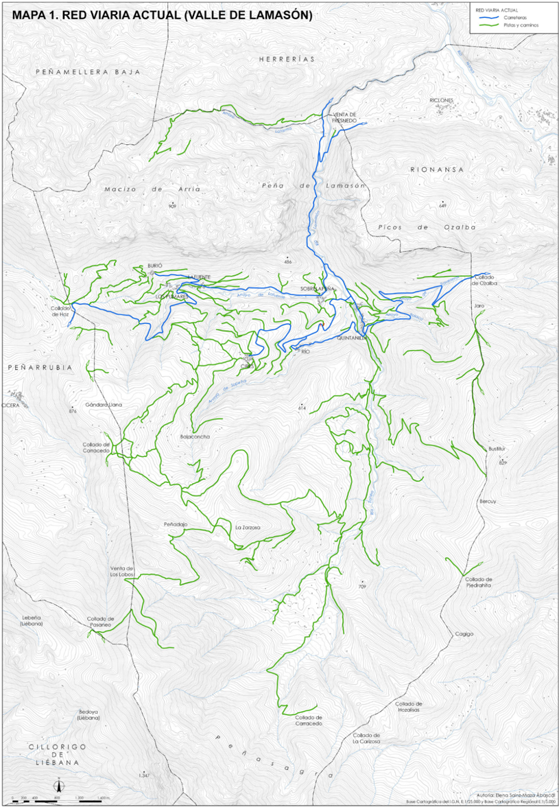
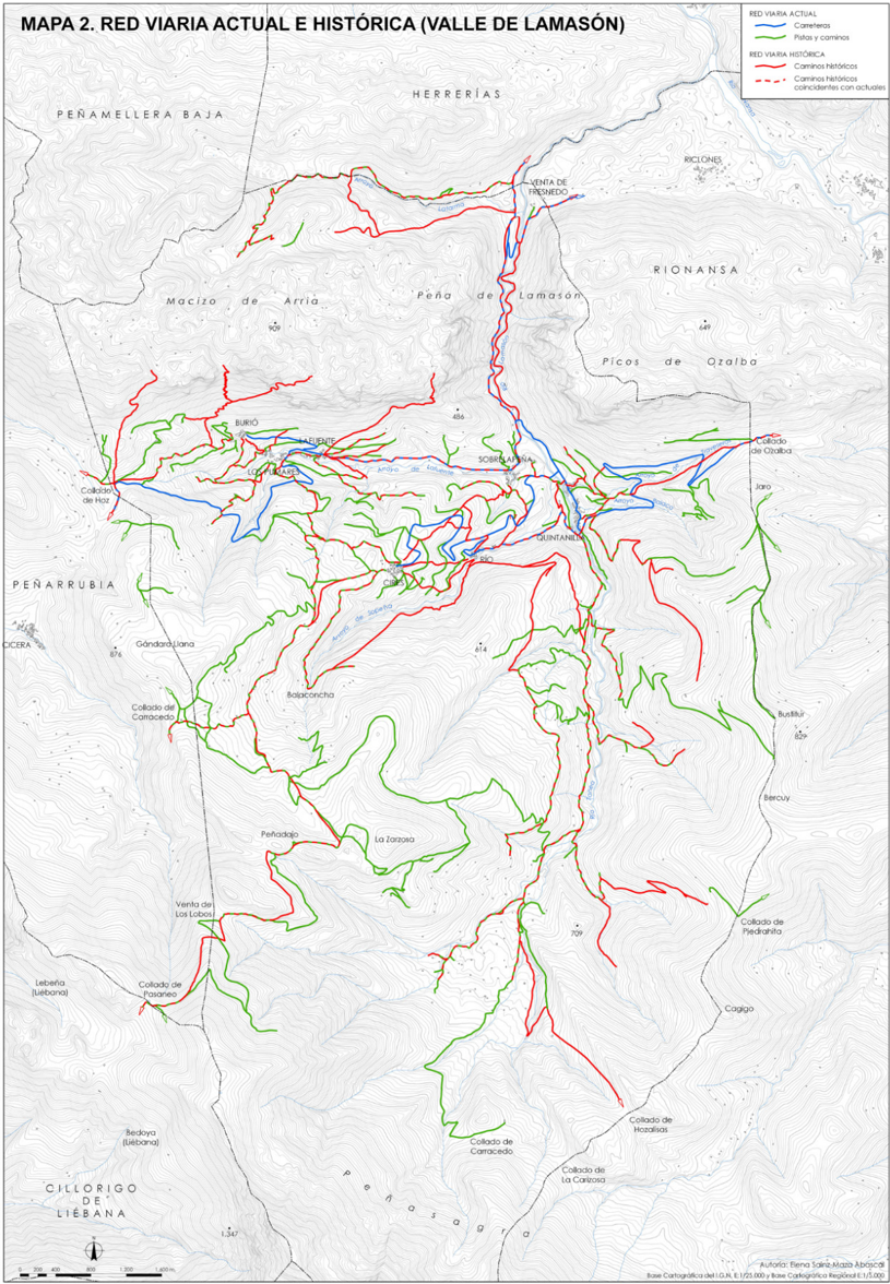
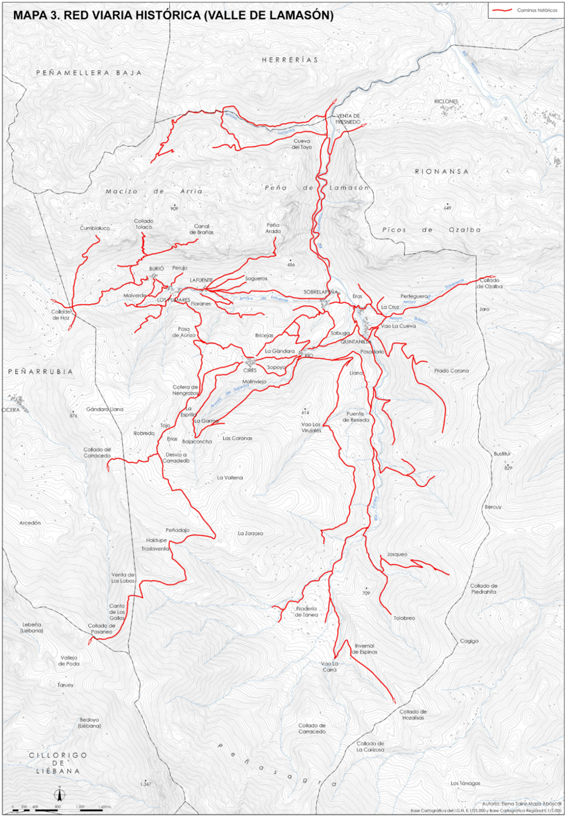
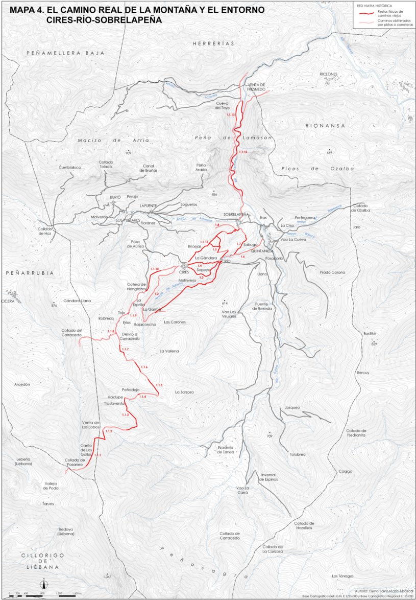
“y gracias a ella, con la imprescindible ayuda de las prospecciones orales y de campo, se pudo trazar la red de caminos antiguos representada en el Mapa 3.”
§ Un ensayo > • Valle
plainstates a cause- Asserted: passes — The authors put it forward as true.
- Checkable: passes — It can be checked against evidence.
- Load-bearing: passes — The paper’s conclusions depend on it.
- Based: passes — The paper gives a reason why it holds.
A result the paper states — it cites no source for it, so there is none to check. The quote shows it is in the paper.
In the paper
“Ese trabajo de reconstrucción cartográfica no hubiese sido posible sin la participación de la documentación.”
§ Un ensayo > 3.2. Documentación de la red viaria histórica
plainstates a cause- Asserted: passes — The authors put it forward as true.
- Checkable: passes — It can be checked against evidence.
- Load-bearing: passes — The paper’s conclusions depend on it.
- Based: passes — The paper gives a reason why it holds.
A result the paper states — it cites no source for it, so there is none to check. The quote shows it is in the paper.
In the paper
“de la red viaria histórica anterior a la actual como un todo, sino que se descendió documental y arqueológicamente hasta cada camino de la misma, hasta los principales, los de trajín, y hasta los más secundarios, los locales vecinales y agrarios.”
§ Un ensayo > 5. Referencias bibliográficas
plain- Asserted: passes — The authors put it forward as true.
- Checkable: passes — It can be checked against evidence.
- Load-bearing: passes — The paper’s conclusions depend on it.
- Based: passes — The paper gives a reason why it holds.
A result the paper reports from its own data — it cites no other source for it, so there is none to check. The quote shows it is in the paper.
In the paper
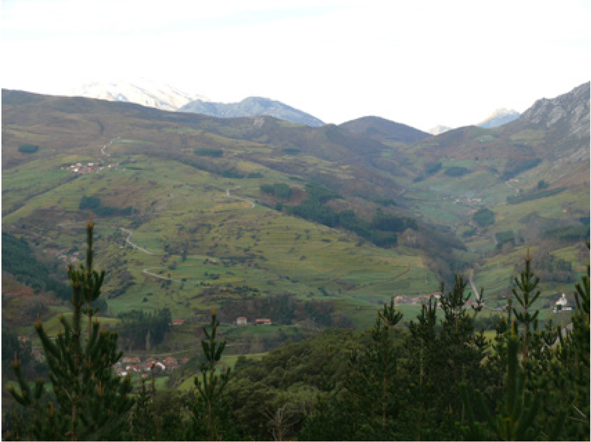
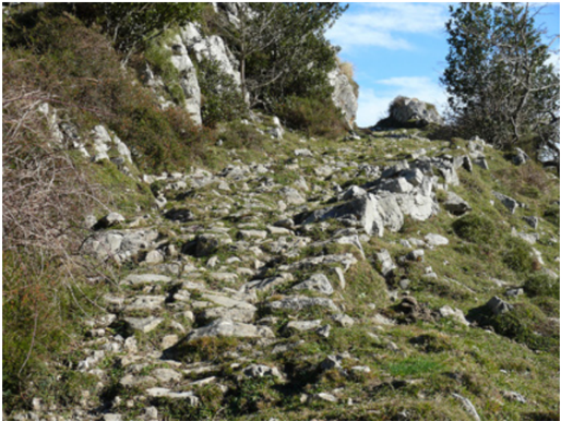
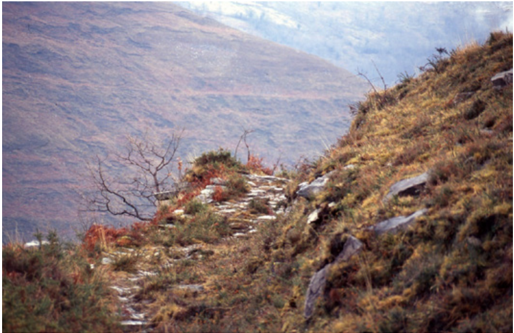
“De esa información arqueológica cabe destacar que la tipología dominante era la de un camino con sección transversal en desmonte y firme de empedrado no muy concertado y levemente armado en su talud descendente con pequeños muretes o hileras de piedras de mayor tamaño (Imagen 2).”
§ Un ensayo > 3.3. Arqueología de los caminos históricos
plain- Asserted: passes — The authors put it forward as true.
- Checkable: passes — It can be checked against evidence.
- Load-bearing: passes — The paper’s conclusions depend on it.
- Based: passes — The paper gives a reason why it holds.
A result the paper states — it cites no source for it, so there is none to check. The quote shows it is in the paper.
In the paper
“Es decir, que la red viaria histórica cartografiada en dicho mapa se refiere sobremanera a caminos de la Edad Moderna, pues por debajo de ese período, en el siglo XVI y las centurias medievales, las referencias se reducen considerablemente y, aun haciendo alusión a asuntos interesantes, como la existencia de ventas y portazgos, tienden a centrarse en el principal camino supralocal del valle.”
§ Un ensayo > • Valle
plainstates an association- Asserted: passes — The authors put it forward as true.
- Checkable: passes — It can be checked against evidence.
- Load-bearing: passes — The paper’s conclusions depend on it.
- Based: passes — The paper gives a reason why it holds.
A statement the paper makes itself — it cites no source for it, so there is none to check. The quote shows it is in the paper.
In the paper
“Mucha menos producción existe para los caminos de los siglos medievales y los dos primeros de la Edad Moderna.”
§ Un ensayo > 1. Introducción
plain- Asserted: passes — The authors put it forward as true.
- Checkable: passes — It can be checked against evidence.
- Load-bearing: passes — The paper’s conclusions depend on it.
- Based: passes — The paper gives a reason why it holds.
A statement the paper makes itself — it cites no source for it, so there is none to check. The quote shows it is in the paper.
In the paper
“la bibliografía específica sobre caminería medieval y postmedieval es cuando menos escasa en comparación con la de otras épocas.”
§ Un ensayo > 1. Introducción
hedged- Asserted: passes — The authors put it forward as true.
- Checkable: passes — It can be checked against evidence.
- Load-bearing: passes — The paper’s conclusions depend on it.
- Based: passes — The paper gives a reason why it holds.
A statement the paper makes itself — it cites no source for it, so there is none to check. The quote shows it is in the paper.
In the paper
“la caminería histórica española rara vez ha pretendido deshilvanar por completo el ovillo de la red y adentrarse en los hilos de las vías más locales, más secundarias pero igualmente fundamentales a la hora de ordenar y articular el territorio.”
§ Un ensayo > 1. Introducción
plain- Asserted: passes — The authors put it forward as true.
- Checkable: passes — It can be checked against evidence.
- Load-bearing: passes — The paper’s conclusions depend on it.
- Based: passes — The paper gives a reason why it holds.
- It may state two separate claims as one. 35
- Probably not a substantial claim. 45
A result the paper reports from its own data — it cites no other source for it, so there is none to check. The quote shows it is in the paper.
In the paper
“pues por debajo de ese período, en el siglo XVI y las centurias medievales, las referencias se reducen considerablemente y, aun haciendo alusión a asuntos interesantes, como la existencia de ventas y portazgos, tienden a centrarse en el principal camino supralocal del valle.”
§ Un ensayo > • Valle
plainstates an association- Asserted: passes — The authors put it forward as true.
- Checkable: passes — It can be checked against evidence.
- Load-bearing: passes — The paper’s conclusions depend on it.
- Based: passes — The paper gives a reason why it holds.
It may state two separate claims as one.
A result the paper states — it cites no source for it, so there is none to check. The quote shows it is in the paper.
In the paper
“El trabajo realizado, aunque aquí haya tenido que reducirse a un simple esbozo y no se haya entrado en multitud de detalles de gran interés, en rigor vino a cumplir los planteamientos metodológicos marcados en su inicio, el estudio de la historia viaria del valle de Lamasón del revés, del presente hacia el pasado y del todo hacia las partes, de la red hasta los caminos concretos.”
§ Un ensayo > 4. Discusión y conclusiones
plain- Asserted: passes — The authors put it forward as true.
- Checkable: passes — It can be checked against evidence.
- Load-bearing: passes — The paper’s conclusions depend on it.
- Based: passes — The paper gives a reason why it holds.
Probably not a substantial claim.
A result the paper reports from its own data — it cites no other source for it, so there is none to check. The quote shows it is in the paper.
In the paper
“Las informaciones más directas hicieron por lo normal alusión a los caminos más importantes, los reales o supralocales, pero más indirectamente también aparecieron menciones a toda una serie de caminos locales, desde los públicos y concejiles hasta las cañadas y senderos, además de a infraestructuras o equipamientos como puentes, pontones, vados, posas o ventas.”
§ Un ensayo > 3.2. Documentación de la red viaria histórica
hedged- Asserted: passes — The authors put it forward as true.
- Checkable: passes — It can be checked against evidence.
- Load-bearing: passes — The paper’s conclusions depend on it.
- Based: passes — The paper gives a reason why it holds.
It may state two separate claims as one.
A result the paper reports from its own data — it cites no other source for it, so there is none to check. The quote shows it is in the paper.
In the paper
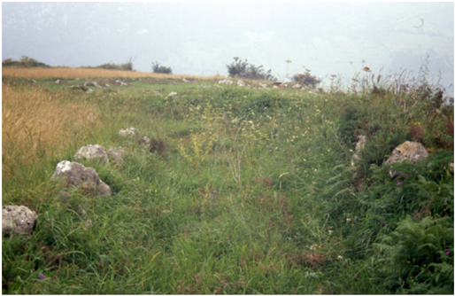
“Quizás lo más interesante en este sentido fue que no se vislumbró una clara diferencia tipológica entre los caminos de trajín y los más locales de uso vecinal y agrario, pues muchos de estos últimos repetían las características de los primeros para simplemente acceder a praderías y cabañas invernales, como puede verse en la Imagen 3.”
§ Un ensayo > 3.3. Arqueología de los caminos históricos
hedged- Asserted: passes — The authors put it forward as true.
- Checkable: passes — It can be checked against evidence.
- Load-bearing: passes — The paper’s conclusions depend on it.
- Based: passes — The paper gives a reason why it holds.
It may state two separate claims as one.
A result the paper states — it cites no source for it, so there is none to check. The quote shows it is in the paper.
In the paper
“pero ni siquiera combinando documentación y prospecciones de campo se pudo llegar apenas más lejos de ahí, y mucho menos interrelacionar en profundidad los caminos con los otros elementos conformadores de los paisajes históricos.”
§ Un ensayo > 5. Referencias bibliográficas
plain- Asserted: passes — The authors put it forward as true.
- Checkable: passes — It can be checked against evidence.
- Load-bearing: passes — The paper’s conclusions depend on it.
- Based: passes — The paper gives a reason why it holds.
It may state two separate claims as one.
A result the paper reports from its own data — it cites no other source for it, so there is none to check. The quote shows it is in the paper.
In the paper
“A modo de ejemplo de la valía de esa documentación y de su gran aporte toponímico, y tomando sólo los protocolos del siglo XVIII, en el Cuadro 1 se registran las referencias a caminos, divididos jerárquica y funcionalmente, y los lugares y sitios por los que pasaban, así como en el Cuadro 2 se relacionan los topónimos camineros aparecidos.”
§ Un ensayo > 3.2. Documentación de la red viaria histórica
plain- Asserted: passes — The authors put it forward as true.
- Checkable: passes — It can be checked against evidence.
- Load-bearing: passes — The paper’s conclusions depend on it.
- Based: passes — The paper gives a reason why it holds.
Probably not a substantial claim. It may state two separate claims as one.
A result the paper states — it cites no source for it, so there is none to check. The quote shows it is in the paper.
In the paper
“(en el curso de esta investigación se solicitó una simple prospección arqueológica con movimiento de materiales en las ruinas de la Venta de los Lobos que fue denegada por los responsables de la Consejería de Cultura del Gobierno de Cantabria)”
§ Un ensayo > 4. Discusión y conclusiones
plainSingle case- Asserted: passes — The authors put it forward as true.
- Checkable: passes — It can be checked against evidence.
- Load-bearing: fails — The paper’s conclusions may not depend on it.
- Based: passes — The paper gives a reason why it holds.
Probably not a substantial claim. The paper’s conclusions may not depend on it. It may state two separate claims as one.
A statement the paper makes itself — it cites no source for it, so there is none to check. The quote shows it is in the paper.
In the paper
“La primera viene dada por las escalas espaciales de análisis empleadas, las cuales la mayoría de las veces han contribuido a separar las redes viarias y los caminos: cuando esas escalas han sido nacionales o regionales la red ha solido tapar a los caminos, reduciéndolos a simples líneas sin apenas fisionomía; mientras que cuando esas escalas han crecido hasta lo comarcal o local, el análisis ha”
§ Un ensayo > 1. Introducción
hedgedstates a cause- Asserted: passes — The authors put it forward as true.
- Checkable: passes — It can be checked against evidence.
- Load-bearing: passes — The paper’s conclusions depend on it.
- Based: passes — The paper gives a reason why it holds.
It may state two separate claims as one.
A statement the paper makes itself — it cites no source for it, so there is none to check. The quote shows it is in the paper.
In the paper
“Todas estas obras, de gran valor documental e histórico, se resienten, eso sí, de una muy escasa o inexistente prospección de campo, lo cual sin duda las lastra a la hora de plantear tipologías constructivas o de proponer itinerarios con referencias territoriales precisas.”
§ Un ensayo > 1. Introducción
plainstates a cause- Asserted: passes — The authors put it forward as true.
- Checkable: passes — It can be checked against evidence.
- Load-bearing: passes — The paper’s conclusions depend on it.
- Based: passes — The paper gives a reason why it holds.
Probably not a substantial claim.
In the paper
“una de las aportaciones más interesantes ha sido la de Manuel Durán (2004) acerca de las técnicas constructivas empleadas en los puentes romanos, las cuales parece que no se cumplen en muchas de las obras catalogadas como tales.”
§ Un ensayo > 1. Introducción
What the sources say
- Not matchedcites Manuel Durán (2004)
Couldn’t be matched to a paper in Crossref, so it can’t be checked.
hedged- Asserted: passes — The authors put it forward as true.
- Checkable: passes — It can be checked against evidence.
- Load-bearing: fails — The paper’s conclusions may not depend on it.
- Based: passes — The paper gives a reason why it holds.
Probably not a substantial claim. The paper’s conclusions may not depend on it. It may state two separate claims as one.
- Not matched
In the paper
“el también norteño de Óscar Lucas (2012), en el que queda de manifiesto para el siglo XVI la mayor importancia del tráfico de herradura y la no necesidad de grandes obras viarias, pues las principales preocupaciones de los mulateros no estaban en el estado de los caminos, sino en las variaciones de los itinerarios propiciadas por las epidemias de peste y en la inexistencia de fletes de retorno.”
§ Un ensayo > 1. Introducción
What the sources say
- Not matchedcites Lucas (2012)
Couldn’t be matched to a paper in Crossref, so it can’t be checked.
boostedstates a cause- Asserted: passes — The authors put it forward as true.
- Checkable: passes — It can be checked against evidence.
- Load-bearing: fails — The paper’s conclusions may not depend on it.
- Based: passes — The paper gives a reason why it holds.
Probably not a substantial claim. The paper’s conclusions may not depend on it. It may state two separate claims as one.
- Not matched
A statement the paper makes itself — it cites no source for it, so there is none to check. The quote shows it is in the paper.
In the paper
“Los estudios de caminería histórica en España, como por lo demás en otros países del entorno inmediato, no se han caracterizado precisamente por haber alcanzado una cierta homogeneidad científica y metodológica.”
§ Un ensayo > 1. Introducción
plain- Asserted: passes — The authors put it forward as true.
- Checkable: passes — It can be checked against evidence.
- Load-bearing: passes — The paper’s conclusions depend on it.
- Based: passes — The paper gives a reason why it holds.
Probably not a substantial claim.
In the paper
“Dicho método debía además escalonarse en tres fases: el análisis morfológico de las redes a escala local, regional y suprarregional, en donde ponía el acento en la búsqueda de anomalías, de segmentos o tramos que no se integran de manera lógica dentro de la red local, y que por ello mismo pertenecerían a otra lógica anterior; el análisis de las fuentes documentales, clasificando todas las mencione”
§ Un ensayo > 2. Metodología
What the sources say
- Not matchedcites Vion (1989)
Couldn’t be matched to a paper in Crossref, so it can’t be checked.
plain- Asserted: passes — The authors put it forward as true.
- Checkable: passes — It can be checked against evidence.
- Load-bearing: passes — The paper’s conclusions depend on it.
- Based: passes — The paper gives a reason why it holds.
Probably not a substantial claim.
- Not matched
In the paper
“Todo un referente que tardó media centuria en dejar paso a una historia estrictamente caminera de España, la que elaboró Menéndez Pidal (1951), y que como en el caso anterior se paró en todas las épocas y en múltiples aspectos viarios.”
§ Un ensayo > 1. Introducción
What the sources say
- Not matchedcites Menéndez Pidal (1951)
Couldn’t be matched to a paper in Crossref, so it can’t be checked.
plain- Asserted: passes — The authors put it forward as true.
- Checkable: passes — It can be checked against evidence.
- Load-bearing: fails — The paper’s conclusions may not depend on it.
- Based: passes — The paper gives a reason why it holds.
Probably not a substantial claim. The paper’s conclusions may not depend on it. It may state two separate claims as one.
- Not matched
The paper states this without a source or data behind it here, so there is nothing to check it against. The quote shows it is in the paper.
In the paper
“Más abundantes han sido, desde luego, los estudios que en mayor medida se han detenido en las vías de épocas históricas concretas, y en especial los que lo han hecho en la romana y en sus calzadas.”
§ Un ensayo > 1. Introducción
plainstates an association- Asserted: passes — The authors put it forward as true.
- Checkable: passes — It can be checked against evidence.
- Load-bearing: fails — The paper’s conclusions may not depend on it.
- Based: fails — The paper may give no reason why it holds.
Probably not a substantial claim. The paper’s conclusions may not depend on it. The paper may give no reason why it holds.
The paper states this without a source or data behind it here, so there is nothing to check it against. The quote shows it is in the paper.
In the paper
“Las obras susceptibles de integrarse dentro de la caminería histórica presentan, en efecto, una gran heterogeneidad.”
§ Un ensayo > 1. Introducción
plain- Asserted: passes — The authors put it forward as true.
- Checkable: passes — It can be checked against evidence.
- Load-bearing: passes — The paper’s conclusions depend on it.
- Based: fails — The paper may give no reason why it holds.
Probably not a substantial claim. The paper may give no reason why it holds.
A statement the paper makes itself — it cites no source for it, so there is none to check. The quote shows it is in the paper.
In the paper
“La controversia está servida por ahí, y no parece que haya un acuerdo cercano.”
§ Un ensayo > 1. Introducción
hedged- Asserted: passes — The authors put it forward as true.
- Checkable: passes — It can be checked against evidence.
- Load-bearing: fails — The paper’s conclusions may not depend on it.
- Based: passes — The paper gives a reason why it holds.
Probably not a substantial claim. The paper’s conclusions may not depend on it.
In the paper
“Marchand (1997) lo desarrolló en un estudio sobre la región de Gâtinais Oriental, trazando sobre la red viaria actual las anomalías encontradas y, con la ayuda de documentación, realizando una lectura cronológica retrospectiva de los cambios sufridos por los itinerarios en diferentes épocas; pero su principal aportación se encuentra en la interrelación que estableció entre el dibujo de la red vi”
§ Un ensayo > 2. Metodología
What the sources say
- Not matchedcites Marchand (1997)
Couldn’t be matched to a paper in Crossref, so it can’t be checked.
plainstates a cause- Asserted: passes — The authors put it forward as true.
- Checkable: passes — It can be checked against evidence.
- Load-bearing: passes — The paper’s conclusions depend on it.
- Based: passes — The paper gives a reason why it holds.
It may state two separate claims as one.
- Not matched
In the paper
“Leturcq (1997) hizo lo propio con la red viaria de Beauce, destacando también las potencialidades interpretativas que su interrelación con el parcelario y con el poblamiento propiciaba dentro de los estudios de los paisajes históricos.”
§ Un ensayo > 2. Metodología
What the sources say
- Not matchedcites Leturcq (1997)
Couldn’t be matched to a paper in Crossref, so it can’t be checked.
plainstates an association- Asserted: passes — The authors put it forward as true.
- Checkable: passes — It can be checked against evidence.
- Load-bearing: fails — The paper’s conclusions may not depend on it.
- Based: passes — The paper gives a reason why it holds.
Probably not a substantial claim. The paper’s conclusions may not depend on it.
- Not matched
In the paper
“los resultados finales fueron presentados como un SIG (Sistema de Información Geográfica) que contiene los mapas de inventario, los de campo, y las fichas de inventario para algunos casos, además de una serie de monografías en donde se resume la historia caminera de cada cantón”
§ Un ensayo > 2. Metodología
What the sources say
- Not matchedcites http://www.viatransfer.viastoria.ch/f/Inventaires/IVS.htm
Couldn’t be matched to a paper in Crossref, so it can’t be checked.
plain- Asserted: passes — The authors put it forward as true.
- Checkable: passes — It can be checked against evidence.
- Load-bearing: fails — The paper’s conclusions may not depend on it.
- Based: passes — The paper gives a reason why it holds.
Probably not a substantial claim. The paper’s conclusions may not depend on it. It may state two separate claims as one.
- Not matched
In the paper
“El método planteado para ello era muy pormenorizado y sistemático, combinando el trabajo a pie de campo con el de archivo y gabinete, para en cada cantón del país llegar a establecer un mapa de inventario, en donde se diferenciaban tres escalas de caminos (iti-nerarios, tramos y segmentos) y tres niveles de importancia de los mismos (nacional, regional y local)”
§ Un ensayo > 2. Metodología
What the sources say
- Not matchedcites Bulletin IVS, 1992
Couldn’t be matched to a paper in Crossref, so it can’t be checked.
plain- Asserted: passes — The authors put it forward as true.
- Checkable: passes — It can be checked against evidence.
- Load-bearing: passes — The paper’s conclusions depend on it.
- Based: passes — The paper gives a reason why it holds.
Probably not a substantial claim. It may state two separate claims as one.
- Not matched
None of the sources cited for this claim could be matched to a paper in Crossref, so there is nothing to check it against.
In the paper
“Por un lado, la línea más clásica, plasmada en obras regionales de autores como Abásolo (1975), Magallón (1987) o Iglesias y Muñiz (1992), que ha venido señalando como vías romanas las afirmadas preferentemente con losas (mejor o peor concertadas)”
§ Un ensayo > 1. Introducción
What the sources say
- Not matchedcites Abásolo (1975)
Couldn’t be matched to a paper in Crossref, so it can’t be checked.
- Not matchedcites Sillières (1976 y 1990)
Couldn’t be matched to a paper in Crossref, so it can’t be checked.
- Not matchedcites Moreno (2004)
Couldn’t be matched to a paper in Crossref, so it can’t be checked.
plainstates an association- Asserted: passes — The authors put it forward as true.
- Checkable: passes — It can be checked against evidence.
- Load-bearing: fails — The paper’s conclusions may not depend on it.
- Based: passes — The paper gives a reason why it holds.
Probably not a substantial claim. The paper’s conclusions may not depend on it. It may state two separate claims as one.
- Not matched
The paper states this without a source or data behind it here, so there is nothing to check it against. The quote shows it is in the paper.
In the paper
“trabajos todos ellos encomiables y muy útiles, pero demasiado lastrados por la combinación de la larga duración cronológica y la pequeña escala espacial.”
§ Un ensayo > 1. Introducción
plainstates a cause- Asserted: passes — The authors put it forward as true.
- Checkable: passes — It can be checked against evidence.
- Load-bearing: passes — The paper’s conclusions depend on it.
- Based: fails — The paper may give no reason why it holds.
Probably not a substantial claim. The paper may give no reason why it holds.
A statement the paper makes itself — it cites no source for it, so there is none to check. The quote shows it is in the paper.
In the paper
“no sólo han surgido de orígenes disciplinarios muy diversos, entre los que cabe destacar los de la geografía, la ingeniería, la arqueología o la historia, sino que han partido de planteamientos muy dispares”
§ Un ensayo > 1. Introducción
plain- Asserted: passes — The authors put it forward as true.
- Checkable: passes — It can be checked against evidence.
- Load-bearing: fails — The paper’s conclusions may not depend on it.
- Based: passes — The paper gives a reason why it holds.
Probably not a substantial claim. The paper’s conclusions may not depend on it. It may state two separate claims as one.
In the paper
“El proyecto de investigación IVS comenzó a fraguarse en el año 1983, con epicentro en la Universidad de Berna y por mandato de la Confederación Helvética, con la pretensión de inventariar, cartografiar y describir la red viaria histórica suiza.”
§ Un ensayo > 2. Metodología
What the sources say
- Not matchedcites Bulletin IVS, 1992
Couldn’t be matched to a paper in Crossref, so it can’t be checked.
plain- Asserted: passes — The authors put it forward as true.
- Checkable: passes — It can be checked against evidence.
- Load-bearing: unclear — It is unclear whether the paper’s conclusions depend on it.
- Based: passes — The paper gives a reason why it holds.
It may state two separate claims as one.
- Not matched
A statement the paper makes itself — it cites no source for it, so there is none to check. The quote shows it is in the paper.
In the paper
“Es en esa centuria cuando se abre la etapa de los caminos reales borbónicos, con su estructura radial y sus grandes obras ingenieriles tendentes a la consecución de vías con firmes dulces, secciones doblemente carreteras y perfiles suaves, preludio de lo que luego habrían de ser las primeras carreteras, ya avanzado el siglo siguiente.”
§ Un ensayo > 1. Introducción
plainstates a cause- Asserted: passes — The authors put it forward as true.
- Checkable: passes — It can be checked against evidence.
- Load-bearing: fails — The paper’s conclusions may not depend on it.
- Based: passes — The paper gives a reason why it holds.
Probably not a substantial claim. The paper’s conclusions may not depend on it. It may state two separate claims as one.
A statement the paper makes itself — it cites no source for it, so there is none to check. The quote shows it is in the paper.
In the paper
“la segunda, irremediablemente asociada con la anterior, lleva a la mirada de los investigadores, por lo normal muy dirigida hacia los caminos supralocales, hacia los caminos de mayor orden jerárquico, los que en red o en solitario han participado de las principales características itinerarias y tipológicas asignadas a las grandes épocas históricas.”
§ Un ensayo > 1. Introducción
plainstates a cause- Asserted: passes — The authors put it forward as true.
- Checkable: passes — It can be checked against evidence.
- Load-bearing: passes — The paper’s conclusions depend on it.
- Based: fails — The paper may give no reason why it holds.
Probably not a substantial claim. The paper may give no reason why it holds.
The paper states this without a source or data behind it here, so there is nothing to check it against. The quote shows it is in the paper.
In the paper
“Quizás el mayor hiato de la caminería histórica española, y en general de buena parte de la europea, haya estado precisamente en una cierta disociación respecto del contexto territorial, en una cierta carencia de visión de conjunto.”
§ Un ensayo > 2. Metodología
hedged- Asserted: passes — The authors put it forward as true.
- Checkable: fails — It may be too vague to check against evidence.
- Load-bearing: passes — The paper’s conclusions depend on it.
- Based: fails — The paper may give no reason why it holds.
Probably not a substantial claim. It may be too vague to check against evidence. The paper may give no reason why it holds. It may state two separate claims as one.
In the paper
“la referencia obligada son los dos volúmenes ampliamente documentados que Santos Madrazo (1984) dedicó a la red viaria nacional, y en mayor medida a la circulación por ella, entre los años centrales del Setecientos y del Ochocientos.”
§ Un ensayo > 1. Introducción
What the sources say
- Not matchedcites Santos Madrazo (1984)
Couldn’t be matched to a paper in Crossref, so it can’t be checked.
plain- Asserted: passes — The authors put it forward as true.
- Checkable: passes — It can be checked against evidence.
- Load-bearing: fails — The paper’s conclusions may not depend on it.
- Based: passes — The paper gives a reason why it holds.
Probably not a substantial claim. The paper’s conclusions may not depend on it.
- Not matched
In the paper
“El planteamiento de Vion (1989) consistía en sustituir el método arqueológico más clásico, que desde el estudio de segmentos concretos de caminos pretendía llegar a la reconstrucción de redes, por otro nuevo y contrario que desde las redes viarias llevase hasta los caminos, prevaleciendo el todo sobre las partes.”
§ Un ensayo > 2. Metodología
What the sources say
- Not matchedcites Vion (1989)
Couldn’t be matched to a paper in Crossref, so it can’t be checked.
plainstates a cause- Asserted: passes — The authors put it forward as true.
- Checkable: passes — It can be checked against evidence.
- Load-bearing: passes — The paper’s conclusions depend on it.
- Based: passes — The paper gives a reason why it holds.
Probably not a substantial claim.
- Not matched
The paper states this without a source or data behind it here, so there is nothing to check it against. The quote shows it is in the paper.
In the paper
“podría decirse que estos trabajos se han solido mover entre el estudio de redes viarias, por lo general ejecutados a escalas pequeñas y sobre vías de carácter supralocal, y el estudio de caminos concretos, también por lo normal de importancia supralocal.”
§ Un ensayo > 1. Introducción
hedgedstates an association- Asserted: passes — The authors put it forward as true.
- Checkable: passes — It can be checked against evidence.
- Load-bearing: passes — The paper’s conclusions depend on it.
- Based: fails — The paper may give no reason why it holds.
Probably not a substantial claim. The paper may give no reason why it holds. It may state two separate claims as one.
The paper states this without a source or data behind it here, so there is nothing to check it against. The quote shows it is in the paper.
In the paper
“Rara vez, sin embargo, se ha imbricado la red y sus vías a escalas grandes y, por tanto, con la participación de los numerosos y variopintos caminos locales”
§ Un ensayo > 1. Introducción
plain- Asserted: passes — The authors put it forward as true.
- Checkable: passes — It can be checked against evidence.
- Load-bearing: passes — The paper’s conclusions depend on it.
- Based: fails — The paper may give no reason why it holds.
Probably not a substantial claim. The paper may give no reason why it holds.
In the paper
“la historia de las obras públicas nacionales pergeñada por el ingeniero vasco Alzola y Minondo (1899), pues en ella, a través de documentación, se hacía un pionero repaso a las políticas camineras y sus logros desde la época romana hasta los años finales del Ochocientos”
§ Un ensayo > 1. Introducción
What the sources say
- Not matchedcites Alzola y Minondo (1899)
Couldn’t be matched to a paper in Crossref, so it can’t be checked.
plain- Asserted: passes — The authors put it forward as true.
- Checkable: passes — It can be checked against evidence.
- Load-bearing: fails — The paper’s conclusions may not depend on it.
- Based: passes — The paper gives a reason why it holds.
Probably not a substantial claim. The paper’s conclusions may not depend on it.
- Not matched
In the paper
“El mismo empeño al que se sumó, casi otro medio siglo después, Uriol Salcedo (1990 y 1992) con sus dos volúmenes de historia de los caminos españoles, en donde la base vuelve a ser la documentación, aunque muy mirada desde el punto de vista de la circulación y de los medios de transporte.”
§ Un ensayo > 1. Introducción
What the sources say
- Not matchedcites Uriol Salcedo (1990 y 1992)
Couldn’t be matched to a paper in Crossref, so it can’t be checked.
plain- Asserted: passes — The authors put it forward as true.
- Checkable: passes — It can be checked against evidence.
- Load-bearing: fails — The paper’s conclusions may not depend on it.
- Based: passes — The paper gives a reason why it holds.
Probably not a substantial claim. The paper’s conclusions may not depend on it. It may state two separate claims as one.
- Not matched
In the paper
“Un giro que conllevaba la utilización de un método regresivo, partiendo cronológicamente de las redes más actuales hacia las más antiguas, y sistemático, considerando espacialmente a todo segmento caminero como parte de una red general.”
§ Un ensayo > 2. Metodología
What the sources say
- Not matchedcites Vion (1989)
Couldn’t be matched to a paper in Crossref, so it can’t be checked.
plain- Asserted: passes — The authors put it forward as true.
- Checkable: passes — It can be checked against evidence.
- Load-bearing: passes — The paper’s conclusions depend on it.
- Based: passes — The paper gives a reason why it holds.
Probably not a substantial claim. It may state two separate claims as one.
- Not matched
In the paper
“Dicho grupo venía experimentando distintas líneas de investigación en el valle de Lamasón, en Cantabria, y por lo que respecta a la línea caminera los trabajos se centraron en el camino histórico más importante del valle, el camino real de La Montaña, cuyo estudio se basó en la combinación de fuentes documentales y fuentes arqueológicas”
§ Un ensayo > 2. Metodología
What the sources say
- Not matchedcites Ansola y Sierra, 2006
Couldn’t be matched to a paper in Crossref, so it can’t be checked.
plain- Asserted: passes — The authors put it forward as true.
- Checkable: passes — It can be checked against evidence.
- Load-bearing: unclear — It is unclear whether the paper’s conclusions depend on it.
- Based: passes — The paper gives a reason why it holds.
It may state two separate claims as one.
- Not matched
The paper states this without a source or data behind it here, so there is nothing to check it against. The quote shows it is in the paper.
In the paper
“se mezclaba la horizontalidad de momentos o fases más o menos fijos con la verticalidad de los procesos históricos, lo sincrónico con lo diacrónico, lo descriptivo con lo explicativo.”
§ Un ensayo > 2. Metodología
plainstates an association- Asserted: passes — The authors put it forward as true.
- Checkable: passes — It can be checked against evidence.
- Load-bearing: fails — The paper’s conclusions may not depend on it.
- Based: fails — The paper may give no reason why it holds.
Probably not a substantial claim. The paper’s conclusions may not depend on it. The paper may give no reason why it holds.
A statement the paper makes itself — it cites no source for it, so there is none to check. The quote shows it is in the paper.
In the paper
“Todos estos trabajos que han derivado en cierta medida del de Vion se caracterizan por contener un innegable interés tanto en lo caminero como en lo paisajístico; pero también por anunciar los puntos más débiles del giro metodológico.”
§ Un ensayo > 2. Metodología
plainstates an association- Asserted: passes — The authors put it forward as true.
- Checkable: passes — It can be checked against evidence.
- Load-bearing: passes — The paper’s conclusions depend on it.
- Based: passes — The paper gives a reason why it holds.
Probably not a substantial claim. It may state two separate claims as one.
The paper states this without a source or data behind it here, so there is nothing to check it against. The quote shows it is in the paper.
In the paper
“las pretendidas combinaciones de distintas escalas espaciales y de diferentes etapas temporales, cuando se han intentado, han solido complicar mucho la lectura de los resultados, con lo que ello supone de puesta en entredicho del esfuerzo empleado.”
§ Un ensayo > 2. Metodología
plainstates a cause- Asserted: passes — The authors put it forward as true.
- Checkable: passes — It can be checked against evidence.
- Load-bearing: passes — The paper’s conclusions depend on it.
- Based: fails — The paper may give no reason why it holds.
Probably not a substantial claim. The paper may give no reason why it holds.
A conclusion the paper draws from its own results — it cites no other source for it, so there is none to check. The quote shows it is in the paper.
In the paper
“de tal manera que por ellos podían circular tanto tráfico arriero, el dominante tratándose de vías supralocales, como tráfico agrario de ganado y de carros del país (carro chillón).”
§ Un ensayo > 3.3. Arqueología de los caminos históricos
hedged- Asserted: passes — The authors put it forward as true.
- Checkable: passes — It can be checked against evidence.
- Load-bearing: unclear — It is unclear whether the paper’s conclusions depend on it.
- Based: passes — The paper gives a reason why it holds.
It may state two separate claims as one.
A conclusion the paper draws from its own results — it cites no other source for it, so there is none to check. The quote shows it is in the paper.
In the paper
“En otros ámbitos que carecen de esas cualidades, como el del valle de Lamasón, es cierto que esta metodología pierde potencialidad, pero eso no necesariamente tiene por qué inhabilitarla.”
§ Un ensayo > 4. Discusión y conclusiones
hedgedstates a possible cause- Asserted: passes — The authors put it forward as true.
- Checkable: passes — It can be checked against evidence.
- Load-bearing: passes — The paper’s conclusions depend on it.
- Based: passes — The paper gives a reason why it holds.
It may state two separate claims as one.
A statement the paper makes itself — it cites no source for it, so there is none to check. The quote shows it is in the paper.
In the paper
“En España, al igual que en Francia, el giro metodológico recaló preferentemente en el ámbito de la arqueología del paisaje, y en especial en estudios arqueomorfológicos realizados en Cataluña.”
§ Un ensayo > 2. Metodología
plain- Asserted: passes — The authors put it forward as true.
- Checkable: passes — It can be checked against evidence.
- Load-bearing: fails — The paper’s conclusions may not depend on it.
- Based: passes — The paper gives a reason why it holds.
Probably not a substantial claim. The paper’s conclusions may not depend on it.
A statement the paper makes itself — it cites no source for it, so there is none to check. The quote shows it is in the paper.
In the paper
“Precisamente esas características físicas, de espacio reducido y bien acotado, y socioeconómicas, con no muy drásticas transformaciones, fueron las que en su día llevaron al grupo de Geografía Histórica del Paisaje a tomarlo como laboratorio de experimentación de sus diversas líneas de investigación.”
§ Un ensayo > 2. Metodología
plainstates a causeSingle case- Asserted: passes — The authors put it forward as true.
- Checkable: passes — It can be checked against evidence.
- Load-bearing: passes — The paper’s conclusions depend on it.
- Based: passes — The paper gives a reason why it holds.
Probably not a substantial claim.
A conclusion the paper draws from its own results — it cites no other source for it, so there is none to check. The quote shows it is in the paper.
In the paper
“sino la posible aportación del mismo al deshoje del poblamiento y de sus terrazgos, a la evolución de la organización del espacio en su conjunto.”
§ Un ensayo > 4. Discusión y conclusiones
hedgedstates a possible cause- Asserted: passes — The authors put it forward as true.
- Checkable: unclear — It is unclear whether it could be checked against evidence.
- Load-bearing: passes — The paper’s conclusions depend on it.
- Based: passes — The paper gives a reason why it holds.
It may state two separate claims as one.
A conclusion the paper draws from its own results — it cites no other source for it, so there is none to check. The quote shows it is in the paper.
In the paper
“resulta muy atractiva la acogida de un método que plantea ir del todo hasta las partes, de la red viaria hasta sus caminos, abarcando con ello al conjunto de los elementos que integran los paisajes, incluidas las relaciones entre ellos.”
§ Un ensayo > 2. Metodología
plain- Asserted: passes — The authors put it forward as true.
- Checkable: fails — It may be too vague to check against evidence.
- Load-bearing: passes — The paper’s conclusions depend on it.
- Based: passes — The paper gives a reason why it holds.
Probably not a substantial claim. It may be too vague to check against evidence.
- Rests on an assumption: El giro metodológico de Vion es aplicable al estudio de la caminería histórica del valle de Lamasón.
A statement the paper makes itself — it cites no source for it, so there is none to check. The quote shows it is in the paper.
In the paper
“el también pretendido tránsito desde la red viaria hasta los caminos concretos rara vez ha llegado a su destino, reduciéndose lo arqueológico a la red, a la cartografía de sus itinerarios, y quedando la morfología de los segmentos y de los caminos un tanto huérfana de prospección, si no ausente totalmente de ella.”
§ Un ensayo > 2. Metodología
plain- Asserted: passes — The authors put it forward as true.
- Checkable: passes — It can be checked against evidence.
- Load-bearing: passes — The paper’s conclusions depend on it.
- Based: fails — The paper may give no reason why it holds.
Probably not a substantial claim. The paper may give no reason why it holds. It may state two separate claims as one.
A statement the paper makes itself — it cites no source for it, so there is none to check. The quote shows it is in the paper.
In the paper
“Su promotor, Éric Vion, ya dijo que se trataba de investigaciones complejas que, para alcanzar su máximo rendimiento, dependían mucho de las fuentes y del marco espacial.”
§ Un ensayo > 4. Discusión y conclusiones
plainstates a cause- Asserted: passes — The authors put it forward as true.
- Checkable: passes — It can be checked against evidence.
- Load-bearing: fails — The paper’s conclusions may not depend on it.
- Based: passes — The paper gives a reason why it holds.
Probably not a substantial claim. The paper’s conclusions may not depend on it. It may state two separate claims as one.
A conclusion the paper draws from its own results — it cites no other source for it, so there is none to check. The quote shows it is in the paper.
In the paper
“Independientemente de que la historia vaya de delante hacia atrás o de atrás hacia delante, la conjunción de las fuentes documentales y de las monumentales o arqueológicas, del trabajo de gabinete y archivo y del trabajo de campo, y la consideración de la red viaria en su conjunto y de los caminos concretos individualizados, puede verse como un avance integrador dentro de esas investigaciones.”
§ Un ensayo > 4. Discusión y conclusiones
hedgedstates a possible causeSingle case- Asserted: passes — The authors put it forward as true.
- Checkable: fails — It may be too vague to check against evidence.
- Load-bearing: passes — The paper’s conclusions depend on it.
- Based: passes — The paper gives a reason why it holds.
Probably not a substantial claim. It may be too vague to check against evidence.
A conclusion the paper draws from its own results — it cites no other source for it, so there is none to check. The quote shows it is in the paper.
In the paper
“Teniendo en cuenta esa perspectiva geohistórica, no es de extrañar el buen encaje en ella de los planteamientos de Vion.”
§ Un ensayo > 2. Metodología
boostedstates an association- Asserted: passes — The authors put it forward as true.
- Checkable: fails — It may be too vague to check against evidence.
- Load-bearing: passes — The paper’s conclusions depend on it.
- Based: passes — The paper gives a reason why it holds.
Probably not a substantial claim. It may be too vague to check against evidence.
A conclusion the paper draws from its own results — it cites no other source for it, so there is none to check. The quote shows it is in the paper.
In the paper
“a la escala de los caminos de la red, aparte de la información de los elementos viarios asociados, la remota probabilidad de encontrar en ellos materiales susceptibles de ser sometidos a dataciones absolutas o relativas, lo fiaba todo a las posibilidades de las cronotipologías, lo que si ya resultaba problemático en caminos supralocales muy importantes, en los más marginales respecto de las”
§ Un ensayo > 5. Referencias bibliográficas
plainstates a cause- Asserted: passes — The authors put it forward as true.
- Checkable: passes — It can be checked against evidence.
- Load-bearing: passes — The paper’s conclusions depend on it.
- Based: passes — The paper gives a reason why it holds.
It may state two separate claims as one.
In the paper
“Para el autor estadounidense el objetivo científico de su geografía eran los paisajes culturales del pasado, los que el hombre había ido modelando y construyendo sobre el marco físico a través de largos procesos; el método de estudio era el morfológico, el que entrelazaba las fuentes documentales con el trabajo de campo en busca de vestigios culturales en paisajes actuales”
§ Un ensayo > 2. Metodología
What the sources say
- Not matchedcites Sauer (1941)
Couldn’t be matched to a paper in Crossref, so it can’t be checked.
plain- Asserted: passes — The authors put it forward as true.
- Checkable: passes — It can be checked against evidence.
- Load-bearing: passes — The paper’s conclusions depend on it.
- Based: passes — The paper gives a reason why it holds.
It may state two separate claims as one.
- Not matched
A conclusion the paper draws from its own results — it cites no other source for it, so there is none to check. The quote shows it is in the paper.
In the paper
“Esto, a tenor del breve estado de la cuestión respecto de los estudios de caminería histórica abordado en la introducción, no deja de suponer una apreciable aportación, posible gracias al método de trabajo empleado y a una concepción más amplia y a más escalas de lo viario.”
§ Un ensayo > 5. Referencias bibliográficas
hedgedstates a cause- Asserted: passes — The authors put it forward as true.
- Checkable: fails — It may be too vague to check against evidence.
- Load-bearing: passes — The paper’s conclusions depend on it.
- Based: passes — The paper gives a reason why it holds.
Probably not a substantial claim. It may be too vague to check against evidence. It may state two separate claims as one.
In the paper
“Palet (1998 y 2005), por su parte, ha desarrollado el método en diversos estudios de casos en los que, con un papel muy destacado de la fotografía aérea, se ha dedicado a reconstruir las arqueoformas de las redes viarias y de los parcelarios en busca de anomalías y de diferentes estructuras de organización.”
§ Un ensayo > 2. Metodología
What the sources say
- Not matchedcites Palet (1998 y 2005)
Couldn’t be matched to a paper in Crossref, so it can’t be checked.
plain- Asserted: passes — The authors put it forward as true.
- Checkable: passes — It can be checked against evidence.
- Load-bearing: fails — The paper’s conclusions may not depend on it.
- Based: passes — The paper gives a reason why it holds.
Probably not a substantial claim. The paper’s conclusions may not depend on it.
- Not matched
In the paper
“Gérard Chouquer (2000), uno de los más prolíficos y prestigiosos arqueólogos del paisaje europeos, vino a considerar el giro de Vion como el método a seguir en el caso del estudio de redes históricas y territoriales.”
§ Un ensayo > 2. Metodología
What the sources say
- Not matchedcites Chouquer (2000)
Couldn’t be matched to a paper in Crossref, so it can’t be checked.
plain- Asserted: passes — The authors put it forward as true.
- Checkable: passes — It can be checked against evidence.
- Load-bearing: fails — The paper’s conclusions may not depend on it.
- Based: passes — The paper gives a reason why it holds.
Probably not a substantial claim. The paper’s conclusions may not depend on it.
- Not matched
In the paper
“Bolòs (2004 y 2013) sobre todo ha subrayado el nuevo y fundamental papel que adquirían los estudios de las redes viarias así concebidos, en correlación con los del parcelario y el poblamiento, para conocer mejor los paisajes arqueológicos.”
§ Un ensayo > 2. Metodología
What the sources say
- Not matchedcites Bolòs (2004 y 2013)
Couldn’t be matched to a paper in Crossref, so it can’t be checked.
boostedstates an association- Asserted: passes — The authors put it forward as true.
- Checkable: passes — It can be checked against evidence.
- Load-bearing: fails — The paper’s conclusions may not depend on it.
- Based: passes — The paper gives a reason why it holds.
Probably not a substantial claim. The paper’s conclusions may not depend on it.
- Not matched
A conclusion the paper draws from its own results — it cites no other source for it, so there is none to check. The quote shows it is in the paper.
In the paper
“De hecho, al margen de las deficiencias que pudo tener la propia investigación, y que a buen seguro las tuvo, las limitaciones de las fuentes documentales y de las arqueológicas fueron determinantes en este sentido.”
§ Un ensayo > 5. Referencias bibliográficas
plainstates a cause- Asserted: passes — The authors put it forward as true.
- Checkable: passes — It can be checked against evidence.
- Load-bearing: passes — The paper’s conclusions depend on it.
- Based: passes — The paper gives a reason why it holds.
It may state two separate claims as one.
The paper states this without a source or data behind it here, so there is nothing to check it against. The quote shows it is in the paper.
In the paper
“teniendo en cuenta el carácter fundamental de las redes viarias y de los caminos en la conformación y evolución de los paisajes históricos, en tanto que auténticas líneas articuladoras e integradoras del territorio, los hilos que no sólo ponen en contacto a unas comarcas y regiones con otras, sino que internamente, a una escala más local, marcan los flujos de unión entre núcleos de población y”
§ Un ensayo > 2. Metodología
plainstates a cause- Asserted: passes — The authors put it forward as true.
- Checkable: fails — It may be too vague to check against evidence.
- Load-bearing: passes — The paper’s conclusions depend on it.
- Based: fails — The paper may give no reason why it holds.
Probably not a substantial claim. It may be too vague to check against evidence. The paper may give no reason why it holds. It may state two separate claims as one.
In the paper
“El trabajo de Palet ha estado muy centrado en la fotointerpretación de redes camineras y de parcelarios para, con el apoyo de documentación y partiendo de la premisa de que las estructuras ortogonales estarían relacionadas con la época romana y las radiales con la medieval y posteriores, establecer hipótesis acerca de la configuración y evolución territoriales.”
§ Un ensayo > 2. Metodología
What the sources say
- Not matchedcites Palet (1998 y 2005)
Couldn’t be matched to a paper in Crossref, so it can’t be checked.
hedgedstates an association- Asserted: passes — The authors put it forward as true.
- Checkable: passes — It can be checked against evidence.
- Load-bearing: fails — The paper’s conclusions may not depend on it.
- Based: passes — The paper gives a reason why it holds.
Probably not a substantial claim. The paper’s conclusions may not depend on it. It may state two separate claims as one.
- Not matched
The paper states this without a source or data behind it here, so there is nothing to check it against. The quote shows it is in the paper.
In the paper
“De hecho, tanto en los trabajos de Vion como en los de sus seguidores franceses se eligieron, y es de suponer que no por casualidad, ámbitos espaciales con abundancia de documentación antigua y de restos arqueológicos, además de con un relieve bastante llano.”
§ Un ensayo > 4. Discusión y conclusiones
hedgedstates an association- Asserted: passes — The authors put it forward as true.
- Checkable: passes — It can be checked against evidence.
- Load-bearing: passes — The paper’s conclusions depend on it.
- Based: fails — The paper may give no reason why it holds.
Probably not a substantial claim. The paper may give no reason why it holds.
A conclusion the paper draws from its own results — it cites no other source for it, so there is none to check. The quote shows it is in the paper.
In the paper
“Dadas las características lineales de los caminos, que ejercían por tanto como límites, aparecían numerosas menciones a ellos en compra-ventas o en inventarios de bienes para ubicar las tierras objeto de descripción, y dada la importancia de su mantenimiento y adecuada gestión eran asiduos en los autos de buen gobierno y en las ordenanzas concejiles, y en general dada su frecuentación y su impront”
§ Un ensayo > 3.2. Documentación de la red viaria histórica
plainstates a cause- Asserted: passes — The authors put it forward as true.
- Checkable: passes — It can be checked against evidence.
- Load-bearing: passes — The paper’s conclusions depend on it.
- Based: passes — The paper gives a reason why it holds.
It may state two separate claims as one.
The paper relies on this without support.
El giro metodológico de Vion es aplicable al estudio de la caminería histórica del valle de Lamasón.
“el grupo de Geografía Histórica del Paisaje de la Universidad de Cantabria decidió adoptar también ese giro metodológico en sus estudios camineros.”
The paper relies on this without support.
La red viaria de la Edad Moderna y buena parte de la Contemporánea se fue configurando durante los siglos medievales.
“cuando es de prever que se fuese configurando la red viaria de la Edad Moderna y buena parte de la Contemporánea”
The paper relies on this without support.
El trazado de la red viaria actual puede servir como punto de partida para reconstruir la red viaria histórica una vez expurgado de los elementos más recientes.
“se partió del trazado de la red viaria actual para, una vez expurgada de esos elementos más recientes y novedosos, y con la ayuda del trabajo de campo y del de archivo, ahondar en la histórica”
The paper relies on this without support.
Las tipologías constructivas de los caminos (cronotipologías) pueden aportar temporalidades relativas para los caminos históricos.
“con el fin de conseguir información arqueológica que pudiese enfocar hacia tipos de tráficos (de herradura o carreteros), funcionalidades (supralocales o locales) y, sobre todo, temporalidades relativas a través de sus tipologías (cronotipologías).”
Self-check
Percentages, sums and reported differences re-computed from the paper’s own numbers.
Each contradiction between two passages listed here was confirmed by an independent check.
Rated minor: it would not touch a result — a value no result rests on, a p-value that stays on the same side of the significance level, or a conflict that is clerical, resolved elsewhere in the paper, or outside its own findings.
In the paper
§ Un ensayo > 1. Introducción
“como el temprano de Palacio Atard (1960) sobre el camino real de Reinosa”
§ Un ensayo > Data availability
“• Palacio Atard, Vicente (1060).El comercio de Castilla y el puerto de Santander en el siglo XVIII: notas para su estudio.”
Rated minor: it would not touch a result — a value no result rests on, a p-value that stays on the same side of the significance level, or a conflict that is clerical, resolved elsewhere in the paper, or outside its own findings.
In the paper
§ Un ensayo > 1. Introducción
“autores como el también ingeniero Modesto Vigueras (2004) se suman a las tesis de Isaac Montero”
§ Un ensayo > 1. Introducción
“por los del ingeniero Isaac Moreno (2004) en todo el país y parte de Europa”
Citations
Cites
Still being checked.
Cited by
Sorted by citations
Mazorra, Á. P. (2020) · Advances in Applied Sociology · doi:10.4236/aasoci.2020.107016 · Cited by 3
Inventario de caminos y senderos públicos de Andalucía: metodología y cuantificación
Carmona, M. T., & Moscoso-Sánchez, D. (2026) · Boletín de la Asociación de Geógrafos Españoles · doi:10.21138/bage.3556
Metadata
- Authors
- Ansola Fernández, A.
- Venue
- Cuadernos Geográficos
- Published
- 2018-12-17
- Volume
- 57
- Issue
- 3
- ISSN
- 0210-5462 (ISSN-L)
- 2340-0129
- OpenAlex
- W2903863543
- Semantic Scholar
- a3bf5750682d4f4c6303aabf55971f943553f2b3
- Cited by
- 2
- References
- 0
- Citations by year
- 2026: 1 · 2020: 1
- FWCI
- 1.60
- Type
- journal article
- Language
- es
- Open access
- diamond
- doi.org
- Licence
- cc-by-nc
- Locations
- Cuadernos Geográficos (publishedVersion, cc-by-nc)
- LA Referencia (Red Federada de Repositorios Institucionales de Publicaciones Científicas) (publishedVersion, cc-by-nc)
- e-rph (University of Granada) (submittedVersion)
- Dialnet (Universidad de la Rioja) (submittedVersion)
- UCrea (University of Cantabria) (submittedVersion, cc-by-nc)
- Topics
- Social Sciences › Cultural Studies › Urbanism, Landscape, and Tourism Studies
- Social Sciences › Geography, Planning and Development › Historical Geography and Geographical Thought
- Social Sciences › Arts and Humanities › Archeology (arts and humanities) › Archaeology and Cultural Heritage
- Keywords
- historical cartography, historical road networks, Cantabria, road network reconstruction
About these checks
Registry, retraction, Cites and statistics results are computed, not judged, with one exception: a printed reference that no index lists is read once by a model before it counts as a citation error. Claims are extracted by a model and kept only when their quote appears verbatim in the text; each cited source is then checked, with a model’s help, for whether it says what the claim relies on. Those verdicts can be wrong — read the claim’s quote and the cited source before relying on one.
A language model drew the claims from the paper on 2026-11-10, under version 3 of the claim definition (model deepseek-v4.1-flash, prompt extract-v3).
A second model labelled each claim on 2026-11-10 (model jev-1.13-20260917, definition revision gold-guideline-v0.2).
Statistics and arithmetic are recomputed, not judged.
Confidence bands are shown only for fields calibrated on our annotated test set. None is calibrated yet, so no band is shown.
What counts as a claim ›How we measure confidence ›How we check this ›
Are you an author, or do you see a problem with this page? Request a review
