

The DOI matches its Crossref record; 75 of the 75 references it cites were found in a registry or an index.
Knowledge-Driven GeoAI: Integrating Spatial Knowledge into Multi-Scale Deep Learning for Mars Crater Detection
Open accessAbstract
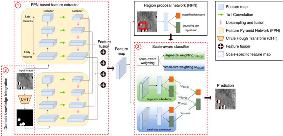
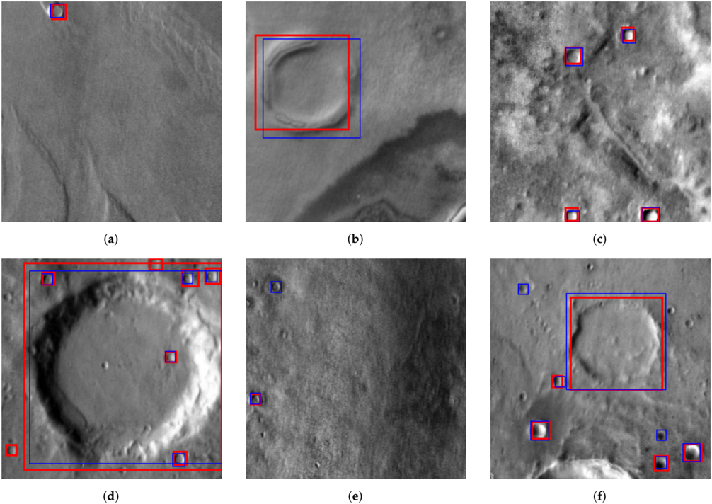
This paper introduces a new GeoAI solution to support automated mapping of global craters on the Mars surface. Traditional crater detection algorithms suffer from the limitation of working only in a semiautomated or multi-stage manner, and most were developed to handle a specific dataset in a small subarea of Mars’ surface, hindering their transferability for global crater detection. As an alternative, we propose a GeoAI solution based on deep learning to tackle this problem effectively. Three innovative features are integrated into our object detection pipeline: (1) a feature pyramid network is leveraged to generate feature maps with rich semantics across multiple object scales; (2) prior geospatial knowledge based on the Hough transform is integrated to enable more accurate localization of potential craters; and (3) a scale-aware classifier is adopted to increase the prediction accuracy of both large and small crater instances. The results show that the proposed strategies bring a significant increase in crater detection performance than the popular Faster R-CNN model. The integration of geospatial domain knowledge into the data-driven analytics moves GeoAI research up to the next level to enable knowledge-driven GeoAI. This research can be applied to a wide variety of object detection and image analysis tasks.
Overview
The claims and statistics of this paper haven’t been checked yet.
Free: it reads the open-access text and checks the first 5 claims that cite a source we can check. Create a free account to check every claim.
Integrity signals
Registry
Cites
Statistics
Figures
Verification
Claims the paper makes
The claims and statistics of this paper haven’t been checked yet.
Free: it reads the open-access text and checks the first 5 claims that cite a source we can check. Create a free account to check every claim.
Claims other papers make about this one
Each is checked against this paper’s own text: does it say what the citing paper says it does?
The source backs part of the claim, not all of it — or backs it for a different population, condition or comparison.
In the citing paper
“Through data-driven analysis, deep learning models have demonstrated the capability to recognize distinctive flood patterns and subtle flood boundaries, even in regions under complex and rapidly changing conditions.”
From Assessment of a new GeoAI foundation model for flood inundation mapping (2023) · cites this paper as [14]
Experimental — accuracy not yet measured
Self-check
Percentages, sums and reported differences re-computed from the paper’s own numbers.
The self-check needs the paper’s full text.
Citations
Cites
Deep Residual Learning for Image Recognition
He, K., Zhang, X., Ren, S., & Sun, J. (2016) · 2016 IEEE Conference on Computer Vision and Pattern Recognition (CVPR) · doi:10.1109/cvpr.2016.90 · Cited by 235,474 · cited 2×
“ResNet50 (pretrained on ImageNet) is used as the feature extractor for both the Faster-RCNN and our proposed models.”
BackgroundU-Net: Convolutional Networks for Biomedical Image Segmentation
Ronneberger, O., Fischer, P., & Brox, T. (2015) · Lecture notes in computer science · doi:10.1007/978-3-319-24574-4_28 · Cited by 99,404
Faster R-CNN: Towards Real-Time Object Detection with Region Proposal Networks
Ren, S., He, K., Girshick, R., & Sun, J. (2017) · IEEE Transactions on Pattern Analysis and Machine Intelligence · doi:10.1109/tpami.2016.2577031 · Cited by 73,472
Microsoft COCO: Common Objects in Context
Lin, T.-Y., Maire, M., Belongie, S., Hays, J., Perona, P., Ramanan, D., Dollár, P., & Zitnick, C. L. (2014) · Lecture Notes in Computer Science · doi:10.1007/978-3-319-10602-1_48 · Cited by 45,460
Fully convolutional networks for semantic segmentation
Long, J., Shelhamer, E., & Darrell, T. (2015) · 2015 IEEE Conference on Computer Vision and Pattern Recognition (CVPR) · doi:10.1109/cvpr.2015.7298965 · Cited by 38,834
Histograms of Oriented Gradients for Human Detection
Dalal, N., & Triggs, B. (2005) · 2005 IEEE Computer Society Conference on Computer Vision and Pattern Recognition (CVPR'05) · doi:10.1109/cvpr.2005.177 · Cited by 33,584 · cited 1×
“This simple yet effective approach has been widely used in both early machine learning methods [52] and recent deep neural networks [53,54].”
Method(2016) · Cited by 31,590
PyTorch: An Imperative Style, High-Performance Deep Learning Library
Paszke, A., Gross, S., Massa, F., Lerer, A., Bradbury, J., Chanan, G., Killeen, T., Lin, Z., Gimelshein, N., Antiga, L., et al. (2019) · arXiv · doi:10.48550/arxiv.1912.01703 · Cited by 31,473 · cited 1×
“The models were developed with the PyTorch [77] machine learning framework.”
MethodFeature Pyramid Networks for Object Detection
Lin, T.-Y., Dollar, P., Girshick, R., He, K., Hariharan, B., & Belongie, S. (2017) · 2017 IEEE Conference on Computer Vision and Pattern Recognition (CVPR) · doi:10.1109/cvpr.2017.106 · Cited by 30,939 · cited 3×
“However, even the state-of-the-art multi-scale CNN-based detectors [59,64] cannot be directly applied for crater detection.”
BackgroundHe, K., Gkioxari, G., Dollar, P., & Girshick, R. (2017) · 2017 IEEE International Conference on Computer Vision (ICCV) · doi:10.1109/iccv.2017.322 · Cited by 29,137
Research works printed but not linked: 2
- Schaber, G.G., and Chadwick, D.J. (1993, January 15–19). Venus’ impact-crater database: Update to approximately 98 percent of the planet’s surface. Proceedings of the Lunar and Planetary Science Conference XXIV, Houston, TX, USA.
- Tewari, A., Verma, V., Srivastava, P., Jain, V., and Khanna, N. (2020). Automated Crater Detection from Co-registered Optical Images, Elevation Maps and Slope Maps using Deep Learning. arXiv.
Cited by
Li, Z. (2022) · Computers, Environment and Urban Systems · doi:10.1016/j.compenvurbsys.2022.101845 · Cited by 1,195
Geomorphometry and terrain analysis: data, methods, platforms and applications
Xiong, L., Li, S., Tang, G., & Strobl, J. (2022) · Earth-Science Reviews · doi:10.1016/j.earscirev.2022.104191 · Cited by 160
Li, W., & Hsu, C.-Y. (2022) · ISPRS International Journal of Geo-Information · doi:10.3390/ijgi11070385 · Cited by 147
Self-citationMSA R-CNN: A comprehensive approach to remote sensing object detection and scene understanding
Sagar, A. S. M. S., Chen, Y., Xie, Y., & Kim, H. S. (2023) · Expert Systems with Applications · doi:10.1016/j.eswa.2023.122788 · Cited by 79
GeoAI for Science and the Science of GeoAI
Li, W., Arundel, S. T., Gao, S., Goodchild, M. F., Hu, Y., Wang, S., & Zipf, A. (2024) · Journal of Spatial Information Science · doi:10.5311/josis.2024.29.349 · Cited by 92
“The leverage and fusion of multi-source geospatial data, as well as the integration of geospatial domain knowledge, are unique to GeoAI research [19].”
Self-citation
Metadata
- Authors
- Hsu, C.-Y., Li, W., & Wang, S.
- Affiliations
- Arizona State University (US)
- Corresponding author
- Li, Wenwen
- Venue
- Remote Sensing
- Publisher
- MDPI AG
- Published
- 2021-05-28
- Volume
- 13
- Issue
- 11
- Pages
- 2116
- ISSN
- 2072-4292 (ISSN-L)
- OpenAlex
- W3172599549
- Cited by
- 53
- References
- 70
- Citations by year
- 2026: 7 · 2025: 14 · 2024: 12 · 2023: 9 · 2022: 9 · 2021: 2
- FWCI
- 2.88
- Type
- journal article
- Language
- en
- Open access
- gold
- doi.org
- Licence
- Locations
- Remote Sensing (publishedVersion, cc-by)
- DOAJ (DOAJ: Directory of Open Access Journals) (submittedVersion, cc-by-sa)
- Funders
- National Science Foundation (1937908, 2033521, 1455349, 1936677, 1853864)
- Topics
- Physical Sciences › Computer Science › Computer Vision and Pattern Recognition › Advanced Neural Network Applications
- Physical Sciences › Earth and Planetary Sciences › Space and Planetary Science › Planetary Science and Exploration
- Physical Sciences › Computer Science › Computer Vision and Pattern Recognition › Remote-Sensing Image Classification
- Keywords
- GeoAI, multi-scale object detection, feature pyramid network, Hough transform, Faster R-CNN
About these checks
Registry, retraction, Cites and statistics results are computed, not judged, with one exception: a printed reference that no index lists is read once by a model before it counts as a citation error. Claims are extracted by a model and kept only when their quote appears verbatim in the text; each cited source is then checked, with a model’s help, for whether it says what the claim relies on. Those verdicts can be wrong — read the claim’s quote and the cited source before relying on one.
Statistics and arithmetic are recomputed, not judged.
Confidence bands are shown only for fields calibrated on our annotated test set. None is calibrated yet, so no band is shown.
What counts as a claim ›How we measure confidence ›How we check this ›
Are you an author, or do you see a problem with this page? Request a review
How to cite
Cite CoChat for the checks on this page, and the paper for its own findings.
- This page
- CoChat. (2026). Citation check: Knowledge-Driven GeoAI: Integrating Spatial Knowledge into Multi-Scale Deep Learning for Mars Crater Detection. https://app.cochat.ai/papers/10.3390/rs13112116
- The paper
- Hsu, C.-Y., Li, W., & Wang, S. (2021). Knowledge-Driven GeoAI: Integrating Spatial Knowledge into Multi-Scale Deep Learning for Mars Crater Detection. Remote Sensing. https://doi.org/10.3390/rs13112116
Data sources
Bibliographic data: Semantic Scholar, OpenAlex, Crossref.
Contains information from the Semantic Scholar Academic Graph Datasets, made available under the ODC Attribution License (ODC-BY 1.0).
Semantic Scholar’s data is described in: Kinney, R., et al. (2023). The Semantic Scholar Open Data Platform. arXiv:2301.10140.
