

The DOI matches its Crossref record; 126 of the 126 references it cites were found in a registry or an index; none of the 105 sources its claims cite is checked for support yet.
A Review on Bathymetric Inversion Research Based on Deep Learning Models and Remote Sensing Images
Open accessAbstract
High-precision inversion of shallow-water depth is crucial to marine resource development, ecological protection, and national defense security. Traditional acoustic detection, LiDAR, and empirical models are limited by high cost, low efficiency, or water quality dependence, struggling to meet people’s growing demand for shallow-water depth. With the rapid development of theories and technologies such as remote sensing information, computer science, and artificial intelligence, bathymetric inversion based on remote sensing images and deep learning models has become a research hotspot. In this study, journal articles and conference papers were searched in the Web of Science (WOS) and Google Scholar databases using keywords such as “remote sensing image”, “bathymetry”, and “deep learning model”. The publication time of the papers ranges from January 2021 to September 2025. A total of 309 relevant studies were retrieved and, after screening and quality control, 132 core studies were finally selected as the research objects for this review. These studies were classified according to deep learning models, including CNN, U-Net, MLP, and RNN. The study analyzed and summarized the characteristics of different deep learning models in bathymetric inversion, as well as their data source selection, inversion accuracy, and limitations. Additionally, the future development trends were discussed in combination with the latest research results.
Overview
CoChat Summary
TL;DR
This review synthesizes 132 core studies (2021–2025) on deep learning-based satellite-derived bathymetry (SDB), organizing them by architecture family (CNN, U-Net, MLP, RNN, Transformer) and comparing their reported performance. It concludes that deep learning substantially outperforms traditional empirical SDB models but remains constrained by scarce in situ depth labels, water clarity, bottom type, sensor characteristics, and cross-region/cross-sensor domain shift.
Key findings
- Deep learning improves shallow-water bathymetry over traditional empirical approaches, but performance is "strongly constrained by water clarity, bottom types, sensor characteristics, and training-label quality"; the dominant bottlenecks are limited in situ depth labels and domain shift across regions, sensors, and turbidity.
- Reported accuracies vary widely across the reviewed models: e.g., Bathymetry Transformer RMSE = 0.375 m (0–12 m, clear coral reef), BOA-CNN-BiLSTM RMSE 0.10–0.38 m (0–28 m), PI-CNN RMSE 1.39–1.56 m with R² > 0.95 (0–40 m), GRU RMSE = 3.69 m with R² = 0.88 (0–32 m), and RT-CNN RMSE = 1.46 m with R² = 0.91 (0–15 m, turbid inland river).
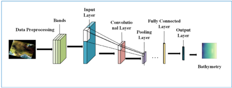
- Architecture-specific strengths: CNNs and the U-Net family excel at multi-scale feature extraction and pixel-level depth mapping; MLPs and SVMs remain strong baselines under small-sample and shallow-water conditions; RNNs (LSTM, BiGRU) model multi-temporal dynamics; Transformers enhance large-area spatial consistency and cross-domain generalization.
- The review identifies future directions: physics–data synergy, uncertainty quantification (epistemic vs. aleatoric), inland water bathymetry, low-data regimes with transfer learning and self-supervision, and computational efficiency for edge deployment.
Methods
- Systematic literature review using Web of Science and Google Scholar, combining controlled subject terms with free-text keywords (deep learning/CNN/U-Net/Transformer; bathymetry/water depth/depth inversion; remote sensing/Sentinel-2/Landsat), plus snowballing from reference lists.
- Screening: an initial retrieval of 540 publications was refined to 309 records explicitly employing deep learning; after duplicate removal and multi-stage screening against predefined inclusion/exclusion criteria, 132 core studies were retained for in-depth analysis. The review focuses on 2021–2025.
- Synthesis is qualitative and comparative: studies are categorized by model architecture, and two summary tables are compiled — Table 1 (research highlights and limitations per model) and Table 2 (quantitative comparison by water type, dataset/labels, generalization test, RMSE/R², and depth range).
Limitations
- Stated by the paper: direct quantitative comparison across studies is problematic because datasets, study regions, water optical conditions, depth ranges, sensor characteristics, training sample sizes, and validation strategies differ substantially; the authors caution that "absolute RMSE values do not necessarily reflect intrinsic model superiority" and that Table 2 is intended as a structured overview rather than a ranking.
- Stated by the paper: systematic benchmarks evaluating transfer performance across cross-regional and cross-sensor scenarios remain limited, making robustness gains hard to quantify; standardized inland bathymetric datasets are scarce, and most benchmarks concentrate on coastal or reef environments.
- Evident from the text: the review is a narrative synthesis without a meta-analysis or pooled effect size, and its conclusions rest on self-reported metrics from heterogeneous primary studies; several entries in Table 2 are marked "N (no cross-scene testing)," so generalization claims are unevenly supported across the surveyed models.
Model-written summary. Check it against the paper before relying on it.
Integrity signals
Registry
Cites
Statistics
Figures




Verification
Claims the paper makes
0 Valid · 7 Not valid · 82 Not checked · 25 Own results and interpretations
A result the paper states — it cites no source for it, so there is none to check. The quote shows it is in the paper.
In the paper
“Deep learning substantially improves shallow-water bathymetry inversion compared with traditional empirical approaches, but performance is strongly constrained by water clarity, bottom types, sensor characteristics, and training-label quality.”
§ A Review on Bathymetric Inversion Research Based on Deep Learning Models and Remote Sensing Images > Abstract
plainstates a cause- Asserted: passes — The authors put it forward as true.
- Checkable: passes — It can be checked against evidence.
- Load-bearing: passes — The paper’s conclusions depend on it.
- Based: passes — The paper gives a reason why it holds.
- Rests on an assumption not shown here.
A result the paper states — it cites no source for it, so there is none to check. The quote shows it is in the paper.
In the paper
“Deep learning substantially improves shallow-water bathymetry inversion compared with traditional empirical approaches, but performance is strongly constrained by water clarity, bottom types, sensor characteristics, and training-label quality.”
§ A Review on Bathymetric Inversion Research Based on Deep Learning Models and Remote Sensing Images > Abstract
boostedstates a cause- Asserted: passes — The authors put it forward as true.
- Checkable: passes — It can be checked against evidence.
- Load-bearing: passes — The paper’s conclusions depend on it.
- Based: passes — The paper gives a reason why it holds.
- Rests on an assumption not shown here.
In the paper
“| BOA-CNN-BILSTM [119] | Clear coastal reef waters | Sentinel-2 MSI + ICESat-2 depths + in situ bathymetric | Y (cross-region) | RMSE: 0.10-0.38 m | 0-28 m |”
§ A Review on Bathymetric Inversion Research Based on Deep Learning Models and Remote Sensing Images > 4.2.5. Computational Efficiency and Edge Deployment
What the sources say
- Not checked yetcites [119] Zhu, 2025, Satellite-Derived Bathymetry Combined With Sentinel-2 and ICESat-2 Datasets Using Deep Learning, IEEE J. Sel. Top. Appl. Earth Obs. Remote Sens. source
plain- Asserted: passes — The authors put it forward as true.
- Checkable: passes — It can be checked against evidence.
- Load-bearing: unclear — It is unclear whether the paper’s conclusions depend on it.
- Based: passes — The paper gives a reason why it holds.
In the paper
“| lightweight U-Net [100] | Clear coastal waters | Sentinel-2 + reference bathymetry | Y (cross-region) | RMSE ≈ 0.81 m | 0-18 m |”
§ A Review on Bathymetric Inversion Research Based on Deep Learning Models and Remote Sensing Images > 4.2.5. Computational Efficiency and Edge Deployment
What the sources say
- Not checked yetcites [100] Anagnostopoulos, C.G., Papaioannou, V., Vlachos, K., Moumtzidou, A., Gialampoukidis, I., Vrochidis, S., and Kompatsiaris, I. (2025). Sentinel-2 Satellite-Derived Bathymetry with Data-Efficient Domain Adaptation. J. Mar. Sci. Eng., 13. source
plain- Asserted: passes — The authors put it forward as true.
- Checkable: passes — It can be checked against evidence.
- Load-bearing: unclear — It is unclear whether the paper’s conclusions depend on it.
- Based: passes — The paper gives a reason why it holds.
In the paper
“| BathyFormer [87] | Turbid estuarine-coastal waters | in situ bathymetric +NOAA reference | Y (cross-region) | RMSE: 0.55-0.73 m | 0-5 m |”
§ A Review on Bathymetric Inversion Research Based on Deep Learning Models and Remote Sensing Images > 4.2.5. Computational Efficiency and Edge Deployment
What the sources say
- Not checked yetcites [87] Lv, Z., Herman, J., Brewer, E., Nunez, K., and Runfola, D. (2025). BathyFormer: A Transformer-Based Deep Learning Method to Map Nearshore Bathymetry with High-Resolution Multispectral Satellite Imagery. Remote Sens., 17. source
plain- Asserted: passes — The authors put it forward as true.
- Checkable: passes — It can be checked against evidence.
- Load-bearing: unclear — It is unclear whether the paper’s conclusions depend on it.
- Based: passes — The paper gives a reason why it holds.
43 more claims
Create a free account to see all 114 claims and to verify the 105 references still open.
- It may state two separate claims as one. 50
- Probably not a substantial claim. 21
Self-check
Percentages, sums and reported differences re-computed from the paper’s own numbers.
Each contradiction between two passages listed here was confirmed by an independent check.
Rated minor: it would not touch a result — a value no result rests on, a p-value that stays on the same side of the significance level, or a conflict that is clerical, resolved elsewhere in the paper, or outside its own findings.
In the paper
§ A Review on Bathymetric Inversion Research Based on Deep Learning Models and Remote Sensing Images > 3.2. Water Depth Inversion Based on U-Net Models
“BathyNet [96] replaces the semantic-segmentation head of a classical U-Net with pixelwise depth regression”
§ A Review on Bathymetric Inversion Research Based on Deep Learning Models and Remote Sensing Images > lightweight U-Net [100]
“BathyNet [95] Emphasizes coastal-blue bands to boost shallow-water penetration; outputs pixel-wise depth.”
Citations
Cites
An Image is Worth 16x16 Words: Transformers for Image Recognition at Scale
Dosovitskiy, A., Beyer, L., Kolesnikov, A., Weissenborn, D., Zhai, X., Unterthiner, T., Dehghani, M., Minderer, M., Heigold, G., Gelly, S., et al. (2020) · arXiv · doi:10.48550/arxiv.2010.11929 · Cited by 47,472
Global Bathymetry and Topography at 15 Arc Sec: SRTM15+
Tozer, B., Sandwell, D. T., Smith, W. H. F., Olson, C., Beale, J. R., & Wessel, P. (2019) · Earth and Space Science · doi:10.1029/2019ea000658 · Cited by 1,003
A new digital bathymetric model of the world's oceans
Weatherall, P., Marks, K. M., Jakobsson, M., Schmitt, T., Tani, S., Arndt, J. E., Rovere, M., Chayes, D., Ferrini, V., & Wigley, R. (2015) · Earth and Space Science · doi:10.1002/2015ea000107 · Cited by 985
Determination of water depth with high-resolution satellite imagery over variable bottom types
Stumpf, R. P., Holderied, K., & Sinclair, M. (2003) · Limnology and Oceanography · doi:10.4319/lo.2003.48.1_part_2.0547 · Cited by 955
Taud, H., & Mas, J. F. (2018) · Lecture Notes in Geoinformation and Cartography · doi:10.1007/978-3-319-60801-3_27 · Cited by 925
Multispectral bathymetry using a simple physically based algorithm
Lyzenga, D. R., Malinas, N. P., & Tanis, F. J. (2006) · IEEE Transactions on Geoscience and Remote Sensing · doi:10.1109/tgrs.2006.872909 · Cited by 467
Convolutional Neural Networks for Multimodal Remote Sensing Data Classification
Wu, X., Hong, D., & Chanussot, J. (2022) · IEEE Transactions on Geoscience and Remote Sensing · doi:10.1109/tgrs.2021.3124913 · Cited by 412
Feng, Y., Xu, H., Jiang, J., Liu, H., & Zheng, J. (2022) · IEEE Transactions on Geoscience and Remote Sensing · doi:10.1109/tgrs.2022.3168331 · Cited by 339
Pacheco, A., Horta, J., Loureiro, C., & Ferreira, Ó. (2015) · Remote Sensing of Environment · doi:10.1016/j.rse.2014.12.004 · Cited by 242
Ashphaq, M., Srivastava, P. K., & Mitra, D. (2021) · Journal of Ocean Engineering and Science · doi:10.1016/j.joes.2021.02.006 · Cited by 200
Nearshore Bathymetry From Fusion of Sentinel-2 and ICESat-2 Observations
Albright, A., & Glennie, C. (2020) · IEEE Geoscience and Remote Sensing Letters · doi:10.1109/lgrs.2020.2987778 · Cited by 167
Darbaghshahi, F. N., Mohammadi, M. R., & Soryani, M. (2021) · IEEE Transactions on Geoscience and Remote Sensing · doi:10.1109/tgrs.2021.3131035 · Cited by 164
Caballero, I., Stumpf, R. P., & Meredith, A. (2019) · Remote Sensing · doi:10.3390/rs11060645 · Cited by 134
Babbel, B. J., Parrish, C., & Magruder, L. A. (2021) · Geophysical Research Letters · doi:10.1029/2020gl090629 · Cited by 128
The Use of Green Laser in LiDAR Bathymetry: State of the Art and Recent Advancements
Szafarczyk, A., & Toś, C. (2022) · Sensors · doi:10.3390/s23010292 · Cited by 105
Confronting turbidity, the major challenge for satellite-derived coastal bathymetry
Caballero, I., & Stumpf, R. P. (2023) · The Science of The Total Environment · doi:10.1016/j.scitotenv.2023.161898 · Cited by 104
Abyssal marine tectonics from the SWOT mission
Yu, Y., Sandwell, D. T., & Dibarboure, G. (2024) · Science · doi:10.1126/science.ads4472 · Cited by 91
AUV-Based Side-Scan Sonar Real-Time Method for Underwater-Target Detection
Tang, Y., Wang, L., Jin, S., Zhao, J., Huang, C., & Yu, Y. (2023) · Journal of Marine Science and Engineering · doi:10.3390/jmse11040690 · Cited by 85
Duan, Z., Chu, S., Cheng, L., Ji, C., Li, M., & Shen, W. (2022) · Optics Express · doi:10.1364/oe.444557 · Cited by 83
Annan, R. F., & Wan, X. (2022) · Surveys in Geophysics · doi:10.1007/s10712-022-09720-5 · Cited by 80
Ai, B., Wen, Z., Wang, Z., Wang, R., Su, D., Li, C., & Yang, F. (2020) · IEEE Journal of Selected Topics in Applied Earth Observations and Remote Sensing · doi:10.1109/jstars.2020.2993731 · Cited by 78
Bathymetry retrieval from optical images with spatially distributed support vector machines
Wang, L., Liu, H., Su, H., & Wang, J. (2018) · GIScience & Remote Sensing · doi:10.1080/15481603.2018.1538620 · Cited by 74
Machine learning based estimation of coastal bathymetry from ICESat-2 and Sentinel-2 data
Xu, N., Wang, L., Zhang, H.-S., Tang, S., Mo, F., & Ma, X. (2024) · IEEE Journal of Selected Topics in Applied Earth Observations and Remote Sensing · doi:10.1109/jstars.2023.3326238 · Cited by 69
Liu, Y., Zhao, J., Deng, R., Liang, Y., Gao, Y., Chen, Q., Xiong, L., Liu, Y., Tang, Y., & Tang, D. (2021) · ISPRS Journal of Photogrammetry and Remote Sensing · doi:10.1016/j.isprsjprs.2021.07.015 · Cited by 68
Pan-European Satellite-Derived Coastal Bathymetry—Review, User Needs and Future Services
Cesbron, G., Melet, A., Almar, R., Lifermann, A., Tullot, D., & Crosnier, L. (2021) · Frontiers in Marine Science · doi:10.3389/fmars.2021.740830 · Cited by 66
A New DTU18 MSS Mean Sea Surface – Improvement from SAR Altimetry
Andersen, O., Knudsen, P., & Stenseng, L. (2018) · Technical University of Denmark, DTU Orbit (Technical University of Denmark, DTU) · Cited by 64
Jing, Z., Sun, J., Lai, Z., & Song, Y. (2022) · Remote Sensing · doi:10.3390/rs14174229 · Cited by 64
Najar, M. A., Benshila, R., Bennioui, Y. E., Thoumyre, G., Almar, R., Bergsma, E. W. J., Delvit, J.-M., & Wilson, D. G. (2022) · Remote Sensing · doi:10.3390/rs14051196 · Cited by 63
Wang, Y., He, X., Bai, Y., Wang, D., Zhu, Q., Gong, F., Yang, D., & Li, T. (2022) · Remote Sensing of Environment · doi:10.1016/j.rse.2022.112955 · Cited by 46
Refraction and coordinate correction with the JONSWAP model for ICESat-2 bathymetry
Zhang, D., Chen, Y., Le, Y., Dong, Y., Dai, G., & Wang, L. (2022) · ISPRS Journal of Photogrammetry and Remote Sensing · doi:10.1016/j.isprsjprs.2022.02.020 · Cited by 45
Satellite-derived bathymetry combined with Sentinel-2 and ICESat-2 datasets using machine learning
Xie, C., Chen, P., Zhang, Z., & Pan, D. (2023) · Frontiers in Earth Science · doi:10.3389/feart.2023.1111817 · Cited by 44
ICESAT-2 shallow bathymetric mapping based on a size and direction adaptive filtering algorithm
Cao, B., Wang, J., Hu, Y., Lv, Y., Yang, X., Gong, H., Li, G., & Lu, X. (2023) · IEEE Journal of Selected Topics in Applied Earth Observations and Remote Sensing · doi:10.1109/jstars.2023.3290672 · Cited by 44
Nearshore Bathymetry from ICESat-2 LiDAR and Sentinel-2 Imagery Datasets Using Physics-Informed CNN
Xie, C., Chen, P., Zhang, S., & Huang, H. (2024) · Remote Sensing · doi:10.3390/rs16030511 · Cited by 44
Bathymetry Model Based on Spectral and Spatial Multifeatures of Remote Sensing Image
Wang, Y., Zhou, X., Li, C., Chen, Y., & Yang, L. (2019) · IEEE Geoscience and Remote Sensing Letters · doi:10.1109/lgrs.2019.2915122 · Cited by 43
A review of active and passive optical methods in hydrography
Mandlburger, G. (2022) · The International Hydrographic Review · doi:10.58440/ihr-28-a15 · Cited by 40
Physics-guided deep neural networks for bathymetric mapping using Sentinel-2 multi-spectral imagery
Qian, S., Chen, Y., Wang, W., Zhang, G., Li, L., Hao, Z., & Wang, Y. (2025) · Frontiers in Marine Science · doi:10.3389/fmars.2025.1636124 · Cited by 40
Rapid estimation of bathymetry from multispectral imagery without in situ bathymetry data
Liu, Y., Deng, R., Qin, Y., Cao, B., Liang, Y., Liu, Y., Tian, J., & Wang, S. (2019) · Applied Optics · doi:10.1364/ao.58.007538 · Cited by 39
Qin, X., Wu, Z., Luo, X., Shang, J., Zhao, D., Zhou, J., Cui, J., Wan, H., & Xu, G. (2024) · ISPRS Journal of Photogrammetry and Remote Sensing · doi:10.1016/j.isprsjprs.2024.09.007 · Cited by 38
Çelik, O. İ., & Gazioğlu, C. (2022) · The Egyptian Journal of Remote Sensing and Space Science · doi:10.1016/j.ejrs.2022.01.010 · Cited by 36
Saeidi, V., Seydi, S. T., Kalantar, B., Ueda, N., Tajfirooz, B., & Shabani, F. (2023) · Geomatics, Natural Hazards and Risk · doi:10.1080/19475705.2023.2225691 · Cited by 36
Yang, H. Y., Ju, J., Guo, H., Qiao, B., Nie, B., & Zhu, L. (2022) · IEEE Journal of Selected Topics in Applied Earth Observations and Remote Sensing · doi:10.1109/jstars.2022.3177227 · Cited by 35
Comparative analysis of singlebeam and multibeam echosounder bathymetric data
Khomsin, Pratomo, D. G., & Saputro, I. (2021) · IOP Conference Series Materials Science and Engineering · doi:10.1088/1757-899x/1052/1/012015 · Cited by 33
Simultaneous mapping of nearshore bathymetry and waves based on physics-informed deep learning
Chen, Q., Wang, N., & Chen, Z. (2023) · Coastal Engineering · doi:10.1016/j.coastaleng.2023.104337 · Cited by 31
Cheng, J., Cheng, L., Chu, S., Li, J., Hu, Q., Ye, L., Wang, Z., & Chen, H. (2023) · ISPRS International Journal of Geo-Information · doi:10.3390/ijgi12090381 · Cited by 31
Ashphaq, M., Srivastava, P. K., & Mitra, D. (2023) · Regional Studies in Marine Science · doi:10.1016/j.rsma.2023.102920 · Cited by 29
Agrafiotis, P., & Demir, B. (2025) · ISPRS Journal of Photogrammetry and Remote Sensing · doi:10.1016/j.isprsjprs.2025.04.020 · Cited by 28
BathyNet: A Deep Neural Network for Water Depth Mapping from Multispectral Aerial Images
Mandlburger, G., Kölle, M., Nübel, H., & Soergel, U. (2021) · PFG – Journal of Photogrammetry, Remote Sensing and Geoinformation Science · doi:10.1007/s41064-021-00142-3 · Cited by 27
Mokhtar, K., Chuah, L. F., Abdullah, M. A., Oloruntobi, O., Ruslan, S. M. M., Albasher, G. I., Ali, A. M., & Akhtar, M. S. (2023) · Environmental Research · doi:10.1016/j.envres.2023.117314 · Cited by 27
A Robust Algorithm for Photon Denoising and Bathymetric Estimation Based on ICESat-2 Data
Zhong, J., Liu, X., Shen, X., & Jiang, L. (2023) · Remote Sensing · doi:10.3390/rs15082051 · Cited by 25
Band-Optimized Bidirectional LSTM Deep Learning Model for Bathymetry Inversion
Xi, X., Chen, M., Wang, Y., & Yang, H. (2023) · Remote Sensing · doi:10.3390/rs15143472 · Cited by 25
Abdallah, M., Ghany, R. A. E., Rabah, M., & Zaki, A. (2022) · The Egyptian Journal of Remote Sensing and Space Science · doi:10.1016/j.ejrs.2022.03.016 · Cited by 24
Shen, W., Chen, M., Wu, Z., & Wang, J. (2023) · IEEE Journal of Selected Topics in Applied Earth Observations and Remote Sensing · doi:10.1109/jstars.2023.3310166 · Cited by 24
Almar, R., Bergsma, E. W. J., Thoumyre, G., Solange, L.-C., Loyer, S., Artigues, S., Salles, G., Garlan, T., & Lifermann, A. (2024) · Coastal Engineering · doi:10.1016/j.coastaleng.2024.104458 · Cited by 24
Duan, Z., Cheng, L., Mao, Q., Song, Y., Zhou, X., Li, M., & Gong, J. (2024) · ISPRS Journal of Photogrammetry and Remote Sensing · doi:10.1016/j.isprsjprs.2024.10.009 · Cited by 24
An APMLP Deep Learning Model for Bathymetry Retrieval Using Adjacent Pixels
Zhu, J., Qin, J., Yin, F., Ren, Z., Qi, J., Zhang, J., & Wang, R. (2022) · IEEE Journal of Selected Topics in Applied Earth Observations and Remote Sensing · doi:10.1109/jstars.2021.3134013 · Cited by 23
Guo, H., Wan, X., & Wang, H. (2024) · IEEE Journal of Selected Topics in Applied Earth Observations and Remote Sensing · doi:10.1109/jstars.2024.3382976 · Cited by 23
Shallow Water Bathymetry Inversion Based on Machine Learning Using ICESat-2 and Sentinel-2 Data
Ye, M., Yang, C., Zhang, X., Li, S., Peng, X., Li, Y., & Chen, T. (2024) · Remote Sensing · doi:10.3390/rs16234603 · Cited by 23
Underwater Topography Inversion in Liaodong Shoal Based on GRU Deep Learning Model
Leng, Z., Zhang, J., Ma, Y., & Zhang, J. (2020) · Remote Sensing · doi:10.3390/rs12244068 · Cited by 22
Leng, Z., Zhang, J., Ma, Y., & Zhang, J. (2023) · Remote Sensing · doi:10.3390/rs15020460 · Cited by 22
Jiang, X. G., Guo, J., Lin, M., Sun, H., & Jiang, T. (2024) · Geophysical Journal International · doi:10.1093/gji/ggae301 · Cited by 22
Wan, J., & Ma, Y. (2021) · Journal of the Indian Society of Remote Sensing · doi:10.1007/s12524-020-01255-9 · Cited by 21
ICESat-2 Bathymetry: Advances in Methods and Science
Parrish, C. E., Magruder, L., Herzfeld, U., Thomas, N., Markel, J., Jasinski, M., Imahori, G., Herrmann, J., Trantow, T., Borsa, A., et al. (2022) · OCEANS 2022, Hampton Roads · doi:10.1109/oceans47191.2022.9977206 · Cited by 21
Zhong, J., Sun, J., & Lai, Z. (2024) · IEEE Journal of Selected Topics in Applied Earth Observations and Remote Sensing · doi:10.1109/jstars.2024.3396374 · Cited by 21
Lowell, K., & Rzhanov, Y. (2024) · GIScience & Remote Sensing · doi:10.1080/15481603.2023.2297549 · Cited by 20
Zhang, S., Zhang, D., Huang, G., Wan, J., Kang, Y., Jiang, D., Xia, B., Zhao, Z., & Liu, R. (2025) · Journal of Hydrology · doi:10.1016/j.jhydrol.2025.133683 · Cited by 20
Modeling and analyzing water column forward scattering effect on airborne LiDAR bathymetry
Yang, F., Qi, C., Su, D., Ma, Y., He, Y., Wang, X. H., & Liu, J. (2023) · IEEE Journal of Oceanic Engineering · doi:10.1109/joe.2023.3275695 · Cited by 19
Alevizos, E., Nicodemou, V. C., Makris, A., Oikonomidis, I., Roussos, A., & Alexakis, D. D. (2022) · Remote Sensing · doi:10.3390/rs14174160 · Cited by 18
Agrafiotis, P., Janowski, Ł., Skarlatos, D., & Demir, B. (2024) · IGARSS 2024 - 2024 IEEE International Geoscience and Remote Sensing Symposium · doi:10.1109/igarss53475.2024.10641355 · Cited by 18
Yang, J., Ma, Y., Zheng, H., Gu, Y., Zhou, H., & Li, S. (2023) · Remote Sensing · doi:10.3390/rs15040931 · Cited by 17
Calculation of Bosten Lake Water Storage Based on Multiple Source Remote Sensing Imagery
Wang, W., Fei, Z., Shi, J., Zhao, Q., Liu, C., Tan, M. L., Kung, H., Gao, G., & Li, G. (2023) · IEEE Transactions on Geoscience and Remote Sensing · doi:10.1109/tgrs.2023.3338635 · Cited by 17
Sun, S., Chen, Y., Mu, L., Le, Y., & Zhao, H. (2023) · Remote Sensing · doi:10.3390/rs15174247 · Cited by 16
Çelik, O. İ., Büyüksalih, G., & Gazioğlu, C. (2023) · Journal of Marine Science and Engineering · doi:10.3390/jmse11112090 · Cited by 16
He, J., Zhang, S., Feng, W., Cui, X., & Zhong, M. (2025) · Remote Sensing of Environment · doi:10.1016/j.rse.2025.114614 · Cited by 16
Zhao, F., Xu, Y., Zheng, N., Tu, Z., & Yang, F. (2025) · Geophysical Journal International · doi:10.1093/gji/ggaf081 · Cited by 16
A Small-Sample Target Detection Method of Side-Scan Sonar Based on CycleGAN and Improved YOLOv8
Zheng, Y., Yan, J., Meng, J., & Liang, M. (2025) · Applied Sciences · doi:10.3390/app15052396 · Cited by 15
Lv, Z., Herman, J., Brewer, E., Nunez, K., & Runfola, D. (2025) · Remote Sensing · doi:10.3390/rs17071195 · Cited by 15
Cheng, J., Chu, S., & Cheng, L. (2025) · IEEE Journal of Selected Topics in Applied Earth Observations and Remote Sensing · doi:10.1109/jstars.2025.3564362 · Cited by 14
Zhu, W., Cao, T., Luan, K., Liu, S., Liu, Z., Xu, Y., & Huang, Y. (2024) · IEEE Journal of Selected Topics in Applied Earth Observations and Remote Sensing · doi:10.1109/jstars.2024.3492492 · Cited by 13
Fusing SAR image and CYGNSS data for monitoring river water level changes by machine learning
Jia, Y. M., Liu, Q., Song, C., Xiao, Z., Dai, Q., Jin, S., & Savi, P. (2025) · Remote Sensing of Environment · doi:10.1016/j.rse.2025.114927 · Cited by 13
Seafloor-Invariant Caustics Removal From Underwater Imagery
Agrafiotis, P., Karantzalos, K. G., & Georgopoulos, A. (2023) · IEEE Journal of Oceanic Engineering · doi:10.1109/joe.2023.3277168 · Cited by 12
Chen, H., Cheng, L., & Zhang, K. (2025) · GIScience & Remote Sensing · doi:10.1080/15481603.2025.2471193 · Cited by 12
Sun, Y., Zheng, W., Li, Z., Zhou, Z., & Zhou, X. (2023) · Journal of Marine Science and Engineering · doi:10.3390/jmse11040853 · Cited by 11
A Convolutional Neural Network with Spatial Location Integration for Nearshore Water Depth Inversion
He, C., Jiang, Q., Tao, G., & Zhang, Z. (2023) · Sensors · doi:10.3390/s23208493 · Cited by 11
Chen, Y., Wu, L., Qian, Y., Le, Y., Yang, Y., Zhang, D., Zhou, L., Guo, H., & Wang, L. (2025) · Remote Sensing of Environment · doi:10.1016/j.rse.2025.114615 · Cited by 11
Garlan, T., Almar, R., & Bergsma, E. W. J. (2025) · Remote Sensing · doi:10.3390/rs17193360 · Cited by 11
Kulbacki, A., Łubczonek, J., & Zaniewicz, G. (2024) · Remote Sensing · doi:10.3390/rs16173165 · Cited by 10
A Multi-Source Convolutional Neural Network for Lidar Bathymetry Data Classification
Zhao, Y., Yu, X., Hu, B., & Chen, R. (2022) · Marine Geodesy · doi:10.1080/01490419.2022.2032498 · Cited by 9
Trans-UNet Network for Predicting Bathymetry in South China Sea From Gravity and Geological Data
Zhou, S., Liao, B., Zhu, F., Li, Y., Li, J., Guo, J., & Sun, H. (2025) · IEEE Journal of Selected Topics in Applied Earth Observations and Remote Sensing · doi:10.1109/jstars.2025.3579250 · Cited by 9
Satellite-Derived Bathymetry Combined With Sentinel-2 and ICESat-2 Datasets Using Deep Learning
Zhu, W., Huang, Y., Cao, T., Zhang, X., Xie, Q., Luan, K., Shen, W., & Zou, Z. (2025) · IEEE Journal of Selected Topics in Applied Earth Observations and Remote Sensing · doi:10.1109/jstars.2025.3589289 · Cited by 9
Deep Learning–Based Bathymetry Mapping from Multispectral Satellite Data Around Europa Island
Nicolas, K. M., Drumetz, L., Lefèvre, S., Tiede, D., Bajjouk, T., & Burnel, J.-C. (2022) · Springer eBooks · doi:10.1007/978-3-031-16213-8_6 · Cited by 8
Liu, Y., Tang, S., Deng, R., Huang, Y., Ye, H., Xu, Z., & Zeng, K. (2023) · IEEE Transactions on Geoscience and Remote Sensing · doi:10.1109/tgrs.2023.3315316 · Cited by 8
Huang, E., Chen, B., Luo, K., & Chen, S. (2024) · Remote Sensing · doi:10.3390/rs16101759 · Cited by 8
Xie, C., Zhang, S., Zhang, Z., Chen, P., & Pan, D. (2025) · Ecological Informatics · doi:10.1016/j.ecoinf.2025.103121 · Cited by 8
Zhou, M., Lee, A. C., Alip, A. E., Dieu, H. T., Leong, Y. L., & Ooi, S. K. (2025) · Remote Sensing · doi:10.3390/rs17173066 · Cited by 8
Lu, T., Yu, Y., Wang, L., Chen, W., Ji, C., Tang, X., & Shao, C. (2023) · Marine Geodesy · doi:10.1080/01490419.2023.2284182 · Cited by 7
Refinement of Marine Gravity Anomaly Over Shallow Waters by Using Satellite-Derived Bathymetry
Wu, Y., Jia, D., Li, Y., He, X., Baltazar Andersen, O., Luo, Z., & Si, X. (2024) · IEEE Transactions on Geoscience and Remote Sensing · doi:10.1109/tgrs.2024.3403421 · Cited by 7
Liu, Z., Liu, H., Ma, Y., Ma, X., Yang, J. P., Jiang, Y., & Li, S. (2024) · Remote Sensing · doi:10.3390/rs16132371 · Cited by 7
Evaluating the Accuracy of Global Bathymetric Models in the Red Sea Using Shipborne Bathymetry
Zaki, A., Bashir, B., Alsalman, A., Elsaka, B., Abdallah, M., & El-Ashquer, M. (2025) · Journal of the Indian Society of Remote Sensing · doi:10.1007/s12524-024-01981-4 · Cited by 7
Mohammad, M. A., Jazireeyan, I., & Pirooznia, M. (2024) · Earth Science Informatics · doi:10.1007/s12145-024-01502-4 · Cited by 7
A Review of Advancements and Applications of Satellite-Derived Bathymetry
Department of Mechanics, A.-F. K. N. U., Kalybekova, A., & Institute of Ionosphere, A. (2025) · Engineered Science · doi:10.30919/es1541 · Cited by 7
Research status and analysis of seafloor topography survey and model development
Hao, R., Wan, X., Sui, X., Jia, Y., & Wu, X. (2022) · DOAJ (DOAJ: Directory of Open Access Journals) · doi:10.19975/j.dqyxx.2021-061 · Cited by 7
Copernicus SENTINEL-2 Geometric Calibration Status
Clerc, S., Neveu, M., Massera, S., Quang, C., Chambrelan, A., Guyot, F., Pessiot, L., Iannone, R. Q., & Boccia, V. (2021) · IEEE International Geoscience and Remote Sensing Symposium (IGARSS) · doi:10.1109/igarss47720.2021.9555090 · Cited by 6
High-Precision Water Depth Inversion in Nearshore Waters With SAR and Machine Learning
Zhang, M., Yang, F., Wang, R., & Qi, C. (2024) · IEEE Geoscience and Remote Sensing Letters · doi:10.1109/lgrs.2024.3360250 · Cited by 6
He, J., Zhang, S., Feng, W., & Lin, J. (2024) · International Journal of Applied Earth Observation and Geoinformation · doi:10.1016/j.jag.2024.103680 · Cited by 6
On Chan, T., Zhang, S., Xia, L., Luo, M., Wu, J., & Awange, J. (2024) · International Journal of Applied Earth Observation and Geoinformation · doi:10.1016/j.jag.2024.103682 · Cited by 6
Band Weight-Optimized BiGRU Model for Large-Area Bathymetry Inversion Using Satellite Images
Xi, X., Guo, G., & Gu, J. (2025) · Journal of Marine Science and Engineering · doi:10.3390/jmse13020246 · Cited by 6
Chu, S., Xu, R., Zhang, X., Cheng, J., Li, J., Hu, Q., Ye, L., & Qu, Z. (2025) · Marine Geodesy · doi:10.1080/01490419.2025.2508771 · Cited by 6
Li, Y., Yang, M., Bian, T., & Wu, H. (2025) · International Journal of Remote Sensing · doi:10.1080/01431161.2025.2518505 · Cited by 6
LSTM-Based Remote Sensing Inversion of Largescale Sand Wave Topography of the Taiwan Banks
Zhao, Y., Zhao, L., Zhang, H., & Fu, B. (2021) · Remote Sensing · doi:10.3390/rs13163313 · Cited by 5
Nearshore topography retrieval based on wave spectrum inverted from Gaofen-3 image
Hao, M., Shao, W., Hu, Y., Migliaccio, M., & Jiang, X. (2025) · Geo-spatial Information Science · doi:10.1080/10095020.2025.2534108 · Cited by 5
A Combined Color and Wave-Based Approach To Satellite Derived Bathymetry Using Deep Learning
Al Najar, M., El Bennioui, Y., Thoumyre, G., Almar, R., Bergsma, E. W. J., Benshila, R., Delvit, J.-M., & Wilson, D. G. (2022) · The International Archives of the Photogrammetry, Remote Sensing and Spatial Information Sciences · doi:10.5194/isprs-archives-xliii-b3-2022-9-2022 · Cited by 4
McCormack, B., & Borrelli, M. (2023) · Remote Sensing · doi:10.3390/rs15061685 · Cited by 4
Editorial: Seafloor mapping using underwater remote sensing approaches
Janowski, Ł., Tęgowski, J., & Montereale-Gavazzi, G. (2023) · Frontiers in Earth Science · doi:10.3389/feart.2023.1306202 · Cited by 4
Zhou, Y., Mao, Z., Mao, Z., Zhang, X., Zhang, L., & Huang, H. (2024) · IEEE Transactions on Geoscience and Remote Sensing · doi:10.1109/tgrs.2024.3468380 · Cited by 4
Suhadha, A. G., Trinugroho, Umbara, R. P., Melati, D. N., Astisiasari, Wisyanto, Arifianti, Y., Trisnafiah, S., Sukristianti, Hadivanto, A. L., et al. (2024) · 2024 IEEE International Conference on Aerospace Electronics and Remote Sensing Technology (ICARES) · doi:10.1109/icares64249.2024.10768018 · Cited by 4
Wave Height Forecasting in the Bay of Bengal Using Multivariate Hybrid Deep Learning Models
Thet, P., Tao, A., Lv, T., & Zheng, J. (2025) · Journal of Marine Science and Engineering · doi:10.3390/jmse13081412 · Cited by 4
Sentinel-2 Satellite-Derived Bathymetry with Data-Efficient Domain Adaptation
Anagnostopoulos, C. G. E., Papaioannou, V., Vlachos, K., Moumtzidou, A., Gialampoukidis, I., Vrochidis, S., & Kompatsiaris, I. (2025) · Journal of Marine Science and Engineering · doi:10.3390/jmse13071374 · Cited by 4
Bathymetric Mapping for Shallow Water Using Landsat 8 via Artificial Neural Network Technique
Patel, A. K., Katiyar, S. K., & Prasad, V. (2020) · Lecture notes in civil engineering · doi:10.1007/978-981-15-5195-6_55 · Cited by 3
Zhu, F., Guo, J., Zhang, H., Huang, L., Sun, H., & Liu, X. (2023) · Zenodo (CERN European Organization for Nuclear Research) · doi:10.5281/zenodo.10096803 · Cited by 3
Assessing the contribution of super-resolution in satellite derived bathymetry in the Antarctic
Gülher, E., Pala, İ., & Alganci, U. (2024) · Estuarine, Coastal and Shelf Science · doi:10.1016/j.ecss.2024.109007 · Cited by 3
Li, Z., & Zheng, G. (2025) · Journal of the Indian Society of Remote Sensing · doi:10.1007/s12524-025-02142-x · Cited by 3
FTT: A Frequency-Aware Texture Matching Transformer for Digital Bathymetry Model Super-Resolution
Xiao, P., Wu, J., & Wang, Y. (2025) · Journal of Marine Science and Engineering · doi:10.3390/jmse13071365 · Cited by 3
Zhao, Y., Fang, S., Wu, Z., Wu, S., Chen, H., Song, C., Mao, Z., & Shen, W. (2025) · Journal of Environmental Management · doi:10.1016/j.jenvman.2025.125034 · Cited by 2
Yang, F., Li, S., Qi, C., Su, D., Wang, X. H., & Zhang, M. (2025) · International Journal of Remote Sensing · doi:10.1080/01431161.2025.2516685 · Cited by 2
Aziz, H., Yulianto, F., Wibowo, M., Perdana, D. H. F., Nurwijayanti, A., & Fachrudin, I. (2026) · Journal of the Indian Society of Remote Sensing · doi:10.1007/s12524-025-02247-3 · Cited by 2
Satellite-based Bathymetry Supported by Extracted Coastlines
Uzakara, H., Demir, N., & Karakış, S. (2024) · PFG – Journal of Photogrammetry, Remote Sensing and Geoinformation Science · doi:10.1007/s41064-024-00298-8 · Cited by 1
Research works printed but not linked: 5
- Annan, 2024, Refined bathymetric prediction based on feature extraction of gravity field signals: BATHY-FE, J. Geophys. Res. Mach. Learn. Comput., 1, e2024JH000205
- Hu, 2024, Water depth extraction of ICESat-2 and application to bathymetric inversion, Chin. J. Geophys., 67, 997
- Vaswani, 2017, Attention is all you need, Adv. Neural Inf. Process. Syst., 30, 5998
- Huang, 2025, Deep Learning Method Suitable for Airborne Laser Bathymetry of Different Water Qualities, Chin. J. Lasers, 52, 0110003
- Shiri, F.M., Perumal, T., Mustapha, N., and Mohamed, R. (2023). A comprehensive overview and comparative analysis on deep learning models: CNN, RNN, LSTM, GRU. arXiv.
Cited by
Multi-Level Multi-Sensor Data Fusion in Bathymetric Modeling: A Systematic Review
Sybilski, H., Fryśkowska, A., & Deliś, P. (2026) · Sustainability · doi:10.3390/su18178784
He, W. E. N., Dai, H., Zhang, G., He, Q., Gao, R., Cui, Q., Yang, T., & Gong, C. (2026) · Journal of Applied Geophysics · doi:10.1016/j.jappgeo.2026.106515
Zhu, F., Li, J., Zhou, S., Li, Y., Zhang, H., Jianqiao, X., Guo, J., Zhou, J., & Sun, H. (2026) · Geo-spatial Information Science · doi:10.1080/10095020.2026.2735740
Wang, Y., He, X., Bai, Y., Li, T., Jin, X., Wang, Z., Zhang, Y., & Gong, F. (2026) · GIScience & Remote Sensing · doi:10.1080/15481603.2026.2753271
Metadata
- Authors
- Liu, D., Shi, Y., & Fang, H.
- Affiliations
- Nanjing Forestry University (CN)
- Corresponding author
- Shi, Yufeng
- Venue
- Remote Sensing
- Publisher
- MDPI AG
- Published
- 2026-02-27
- Volume
- 18
- Issue
- 5
- Pages
- 720
- ISSN
- 2072-4292 (ISSN-L)
- OpenAlex
- W7131819416
- Cited by
- 4
- References
- 126
- Citations by year
- 2026: 4
- FWCI
- 8.09
- Type
- journal article
- Language
- en
- Open access
- gold
- doi.org
- Licence
- Locations
- Remote Sensing (publishedVersion, cc-by)
- DOAJ (DOAJ: Directory of Open Access Journals) (submittedVersion, cc-by-sa)
- Funders
- High-level Scientific Research Foundation of Nanjing Forestry University (163050254)
- Topics
- Physical Sciences › Earth and Planetary Sciences › Oceanography › Underwater Acoustics Research
- Physical Sciences › Earth and Planetary Sciences › Earth-Surface Processes › Coastal and Marine Dynamics
- Life Sciences › Agricultural and Biological Sciences › Forestry › Remote Sensing and LiDAR Applications
- Keywords
- bathymetric inversion, shallow water depth, remote sensing images, deep learning models, convolutional neural networks, U-Net, recurrent neural networks, marine resource development
About these checks
Registry, retraction, Cites and statistics results are computed, not judged, with one exception: a printed reference that no index lists is read once by a model before it counts as a citation error. Claims are extracted by a model and kept only when their quote appears verbatim in the text; each cited source is then checked, with a model’s help, for whether it says what the claim relies on. Those verdicts can be wrong — read the claim’s quote and the cited source before relying on one.
A language model drew the claims from the paper on 2026-11-19, under version 3 of the claim definition (model deepseek-v4.1-flash, prompt extract-v3).
A second model labelled each claim on 2026-11-19 (model jev-1.13-20260917, definition revision gold-guideline-v0.2).
Statistics and arithmetic are recomputed, not judged.
Confidence bands are shown only for fields calibrated on our annotated test set. None is calibrated yet, so no band is shown.
What counts as a claim ›How we measure confidence ›How we check this ›
Are you an author, or do you see a problem with this page? Request a review
Data sources
Bibliographic data: Semantic Scholar, OpenAlex, Crossref.
Contains information from the Semantic Scholar Academic Graph Datasets, made available under the ODC Attribution License (ODC-BY 1.0).
Semantic Scholar’s data is described in: Kinney, R., et al. (2023). The Semantic Scholar Open Data Platform. arXiv:2301.10140.
