

The DOI matches its Crossref record; 60 of the 60 references it cites were found in a registry or an index.
Remote Sensing with UAVs for Flood Modeling: A Validation with Actual Flood Records
Abstract
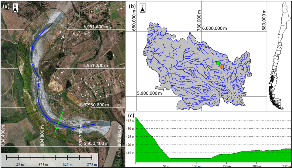
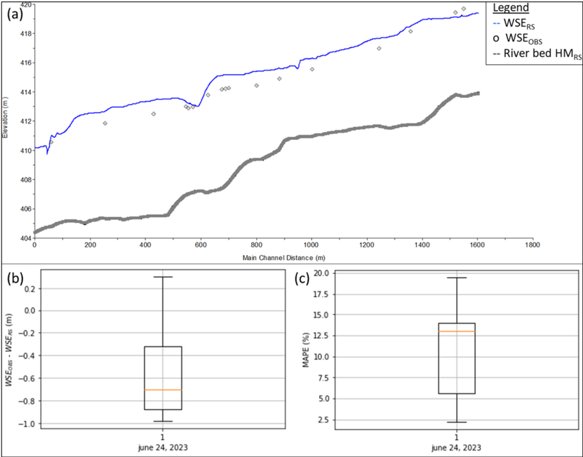
The use of unmanned aerial vehicles (UAVs) is steadily increasing due to their capacity to capture terrain elevation data with remarkable precision and cost-effectiveness. Nonetheless, their application for estimating water surface elevations and submerged terrain, such as channel bathymetry, remains constrained. Consequently, the development of a digital terrain model that relies on UAV data during low-water periods assumes a more extensive dry channel surface area, thus alleviating the information gap regarding submerged terrain. The objective of this brief report is to validate a hydraulic model for flood calculation. To this end, a 1D steady-state hydrological model of the Ñuble River based on a UAV survey in the low-water period of 2016 was constructed in HEC-RAS v.5.0.3 and compared to water surface elevation observations of the flood on 24 June 2023. The model tends to overestimate the flood, but the errors are considered tolerable for flood calculation (on average, a 10.6% depth error was obtained for a 30-year return period flood); therefore, the hydraulic model derived from remote sensing seems to be an effective alternative for the construction of hydraulic models for flood studies.
Overview
The claims and statistics of this paper haven’t been checked yet.
Run the check — free, no account needed. It reads the open-access text and checks the sources it cites.
Integrity signals
Registry
Cites
Statistics
Figures
Verification
Claims the paper makes
The claims and statistics of this paper haven’t been checked yet.
Run the check — free, no account needed. It reads the open-access text and checks the sources it cites.
Claims other papers make about this one
Each is checked against this paper’s own text: does it say what the citing paper says it does?
In the citing paper
“Water surface area was consistently minimal (60 m 2 ), suggesting negligible hydrological influence on these phenological shifts 26 .”
From AI-driven digital twinning quantifies the trade-off between flood conveyance and riparian stability under climate extremes (2026) · cites this paper as [26]
Self-check
Percentages, sums and reported differences re-computed from the paper’s own numbers.
The self-check needs the paper’s full text.
Citations
Cites
A classification of natural rivers
Rosgen, D. L. (1994) · CATENA · doi:10.1016/0341-8162(94)90001-9 · Cited by 1,713
Evaluation of 1D and 2D numerical models for predicting river flood inundation
Horritt, M. S., & Bates, P. D. (2002) · Journal of Hydrology · doi:10.1016/s0022-1694(02)00121-x · Cited by 1,195
Catchment Classification and Hydrologic Similarity
Wagener, T., Sivapalan, M., Troch, P., & Woods, R. (2007) · Geography Compass · doi:10.1111/j.1749-8198.2007.00039.x · Cited by 749
Developments in monitoring and modelling small‐scale river bed topography
Lane, S. N., Richards, K. S., & Chandler, J. H. (1994) · Earth Surface Processes and Landforms · doi:10.1002/esp.3290190406 · Cited by 301
Multitemporal UAV surveys for landslide mapping and characterization
Rossi, G., Tanteri, L., Tofani, V., Vannocci, P., Moretti, S., & Casagli, N. (2018) · Landslides · doi:10.1007/s10346-018-0978-0 · Cited by 263
Carbonneau, P. E., & Dietrich, J. T. (2017) · Earth Surface Processes and Landforms · doi:10.1002/esp.4012 · Cited by 258
Pacheco, A., Horta, J., Loureiro, C., & Ferreira, Ó. (2014) · Remote Sensing of Environment · doi:10.1016/j.rse.2014.12.004 · Cited by 242
Wang, X., & Xie, H. (2018) · Water · doi:10.3390/w10050608 · Cited by 226
Costa, B., Battista, T., & Pittman, S. J. (2009) · Remote Sensing of Environment · doi:10.1016/j.rse.2009.01.015 · Cited by 220
Seamless Mapping of River Channels at High Resolution Using Mobile LiDAR and UAV-Photography
Flener, C., Vaaja, M. T., Jaakkola, A., Krooks, A., Kaartinen, H., Kukko, A., Kasvi, E., Hyyppä, H., Hyyppa, J. M., & Alho, P. (2013) · Remote Sensing · doi:10.3390/rs5126382 · Cited by 207
Acharya, B. S., Bhandari, M., Bandini, F., Pizarro, A., Perks, M. T., Joshi, D. R., Wang, S., Dogwiler, T. J., Ray, R. L., Kharel, G., et al. (2021) · Water Resources Research · doi:10.1029/2021wr029925 · Cited by 203
Flood inundation mapping sensitivity to riverine spatial resolution and modelling approach
Papaioannou, G., Loukas, A. G., Vasiliades, L., & Aronica, G. T. (2016) · Natural Hazards · doi:10.1007/s11069-016-2382-1 · Cited by 184
Human and economic impacts of natural disasters: can we trust the global data?
Jones, R. L., Guha‐Sapir, D., & Tubeuf, S. (2022) · Scientific Data · doi:10.1038/s41597-022-01667-x · Cited by 182
Williams, R. D., Brasington, J., Vericat, D., & Hicks, D. M. (2013) · Earth Surface Processes and Landforms · doi:10.1002/esp.3437 · Cited by 168
Jawak, S. D., Vadlamani, S. S., & Luis, A. J. (2015) · Advances in Remote Sensing · doi:10.4236/ars.2015.42013 · Cited by 149
Classifiers for the detection of flood-prone areas using remote sensed elevation data
Degiorgis, M., Gnecco, G., Gorni, S., Roth, G., Sanguineti, M., & Taramasso, A. C. (2012) · Journal of Hydrology · doi:10.1016/j.jhydrol.2012.09.006 · Cited by 148
Surface flow measurements from drones
Tauro, F., Porfiri, M., & Grimaldi, S. (2016) · Journal of Hydrology · doi:10.1016/j.jhydrol.2016.06.012 · Cited by 145
REMOTE SENSING OF CLEAR-WATER, SHALLOW, GRAVEL-BED RIVERS USING DIGITAL PHOTOGRAMMETRY
Westaway, R., Lane, S. N., & Hicks, D. M. (2001) · Explore Bristol Research · Cited by 141
Mapping River Bathymetry With a Small Footprint Green LiDAR: Applications and Challenges 1
Kinzel, P. J., Legleiter, C. J., & Nelson, J. M. (2012) · JAWRA Journal of the American Water Resources Association · doi:10.1111/jawr.12008 · Cited by 128
Ballesteros‐Cánovas, J. A., Eguibar, M. Á., Bodoque, J. M., Herrero, A. D., Stoffel, M., & Gutiérrez‐Pérez, I. (2010) · Hydrological Processes · doi:10.1002/hyp.7888 · Cited by 121
Muirhead, K., & CRACKNELL, A. P. (1986) · International Journal of Remote Sensing · doi:10.1080/01431168608954714 · Cited by 117
Namara, W. G., Damisse, T. A., & Tufa, F. G. (2021) · Modeling Earth Systems and Environment · doi:10.1007/s40808-021-01166-9 · Cited by 107
Bandini, F., Sunding, T. P., Linde, J., Smith, O., Jensen, I. K., Köppl, C. J., Butts, M., & Bauer‐Gottwein, P. (2019) · Remote Sensing of Environment · doi:10.1016/j.rse.2019.111487 · Cited by 106
Koutalakis, P. D., Tzoraki, O. A., & Zaimes, G. N. (2019) · Drones · doi:10.3390/drones3010014 · Cited by 91
UAV Photogrammetry for Monitoring Changes in River Topography and Vegetation
Watanabe, Y. X., & KAWAHARA, Y. (2016) · Procedia Engineering · doi:10.1016/j.proeng.2016.07.482 · Cited by 88
Levia, D. F., Carlyle‐Moses, D. E., Iida, S., Michalzik, B., Nanko, K., & Tischer, A. (2020) · Ecological studies · doi:10.1007/978-3-030-26086-6 · Cited by 86
Low-cost UAV applications in dynamic tropical volcanic landforms
Granados-Bolaños, S., Quesada‐Román, A., & Alvarado, G. E. (2020) · Journal of Volcanology and Geothermal Research · doi:10.1016/j.jvolgeores.2020.107143 · Cited by 85
Aerial orthoimage generation for UAV remote sensing: Review
Zhang, J., Xu, S., Zhao, Y., Sun, J., Xu, S., & Zhang, X. (2022) · Information Fusion · doi:10.1016/j.inffus.2022.08.007 · Cited by 84
Challenges in paleoflood hydrology applied to risk analysis in mountainous watersheds – A review
Bodoque, J. M., Herrero, A. D., Eguibar, M. Á., Benito, G., Ruíz‐Villanueva, V., & Ballesteros‐Cánovas, J. A. (2014) · Journal of Hydrology · doi:10.1016/j.jhydrol.2014.12.004 · Cited by 82
Comparison of empirical and theoretical remote sensing based bathymetry models in river environments
Flener, C., Lotsari, E., Alho, P., & Käyhkö, J. (2010) · River Research and Applications · doi:10.1002/rra.1441 · Cited by 80
Modelling river channel topography using GIS
Milne, J. A., & Sear, D. (1997) · International Journal of Geographical Information Systems · doi:10.1080/136588197242275 · Cited by 75
Flow Field and Morphology Mapping Using ADCP and Multibeam Techniques: Survey in the Po River
Guerrero, M., & Lamberti, A. (2011) · Journal of Hydraulic Engineering · doi:10.1061/(asce)hy.1943-7900.0000464 · Cited by 74
Kasvi, E., Laamanen, L., Lotsari, E., et al. (2017) · Water · doi:10.3390/w9020106 · Cited by 73
The use of unmanned aerial vehicles in flood hazard assessment
Karamuz, E., Romanowicz, R. J., & Doroszkiewicz, J. (2020) · Journal of Flood Risk Management · doi:10.1111/jfr3.12622 · Cited by 66
Furukawa, F., Laneng, L. A., Ando, H., Yoshimura, N., Kaneko, M., & Morimoto, J. O. (2021) · Drones · doi:10.3390/drones5030097 · Cited by 57
Koljonen, S., Huusko, A., Mäki‐Petäys, A., Louhi, P., & Muotka, T. (2012) · Restoration Ecology · doi:10.1111/j.1526-100x.2012.00908.x · Cited by 55
Testing UAV-derived topography for hydraulic modelling in a tropical environment
Mazzoleni, M., Paron, P., Reali, A., Juízo, D., Manane, J., & Brandimarte, L. (2020) · Natural Hazards · doi:10.1007/s11069-020-03963-4 · Cited by 55
Mapping Topobathymetry in a Shallow Tidal Environment Using Low-Cost Technology
Genchi, S. A., Vitale, A. J., Perillo, G. M. E., Seitz, C., & Delrieux, C. A. (2020) · Remote Sensing · doi:10.3390/rs12091394 · Cited by 54
Castellarin, A., Domeneghetti, A., & Brath, A. (2011) · Physics and Chemistry of the Earth Parts A/B/C · doi:10.1016/j.pce.2011.02.008 · Cited by 50
Kim, J. S., Baek, D., Seo, I. W., & Shin, J. (2019) · Geomorphology · doi:10.1016/j.geomorph.2019.05.016 · Cited by 50
Calculating e-flow using UAV and ground monitoring
Zhao, C., Zhang, C. B., Yang, S. T., Liu, C. M., Xiang, H., Sun, Y., Yang, Z. Y., Zhang, Y., Yu, X., Shao, N. F., et al. (2017) · Journal of Hydrology · doi:10.1016/j.jhydrol.2017.06.047 · Cited by 49
Guidelines for the Use of Unmanned Aerial Systems in Flood Emergency Response
Salmoral, G., Casado, M. R., Muthusamy, M., Butler, D., Menon, P. P., & Leinster, P. (2020) · Water · doi:10.3390/w12020521 · Cited by 49
Flood Disaster Monitoring and Emergency Assessment Based on Multi-Source Remote Sensing Observations
Lei, T., Wang, J., Li, X., Wang, W., Shao, C., & Liu, B. (2022) · Water · doi:10.3390/w14142207 · Cited by 44
River Flow Measurements Utilizing UAV-Based Surface Velocimetry and Bathymetry Coupled with Sonar
Koutalakis, P. D., & Zaimes, G. N. (2022) · Hydrology · doi:10.3390/hydrology9080148 · Cited by 41
Evaluation of DEM generation accuracy from UAS imagery
Santise, M., Fornari, M., Forlani, G., & Roncella, R. (2014) · The international archives of the photogrammetry, remote sensing and spatial information sciences/International archives of the photogrammetry, remote sensing and spatial information sciences · doi:10.5194/isprsarchives-xl-5-529-2014 · Cited by 39
Lamichhane, N., & Sharma, S. (2017) · Hydrology · doi:10.3390/hydrology4020024 · Cited by 37
A multi-agent-based model for sustainable governance of urban flood risk mitigation measures
Koç, K., & Işık, Z. (2020) · Natural Hazards · doi:10.1007/s11069-020-04205-3 · Cited by 33
Schwartz, J. S. (2016) · Water · doi:10.3390/w8110520 · Cited by 31
Comparison of bathymetric data sources used in hydraulic modelling of floods
Bureš, L., Roub, R., Sychová, P., Gdulová, K., & Ďoubalová, J. (2018) · Journal of Flood Risk Management · doi:10.1111/jfr3.12495 · Cited by 28
Drone-Based Bathymetry Modeling for Mountainous Shallow Rivers in Taiwan Using Machine Learning
Lee, C.-H., Liu, L., Wang, Y., Leu, J.-M., & Chen, C.-L. (2022) · Remote Sensing · doi:10.3390/rs14143343 · Cited by 19
River Bathymetry Model Based on Floodplain Topography
Bureš, L., Sychová, P., Máca, P., Roub, R., & Marval, Š. (2019) · Water · doi:10.3390/w11061287 · Cited by 18
analysis of the flash flood in Rhodes island (south Greece) on 22 November 2013 2015
Chatzichristaki, C., Stathis, D., Stefanidis, S. P., & Stefanidis, P. (2015) · Cited by 17
Comparative study of shallow water multibeam imagery for cleaning bathymetry sounding errors
Kammerer, E., Charlot, D., Guillaudeux, S., & Michaux, P. (2001) · doi:10.1109/oceans.2001.968327 · Cited by 11
Exposure age and erosional history of an upland planation surface in the US Atlantic Piedmont
Stanford, S. D., Seidl, M. A., & Ashley, G. M. (2000) · Earth Surface Processes and Landforms · doi:10.1002/1096-9837(200008)25:9<939::aid-esp108>3.0.co;2-0 · Cited by 9
Pandjaitan, N. H., Sutoyo, S., Rau, M. I., Febrita, J., Dharmawan, I. W. E., & Akhmat, I. (2019) · doi:10.1117/12.2541839 · Cited by 9
Buzolic, B., Arumí, J. L., & Jiménez, J. (2021) · Water · doi:10.3390/w13030258 · Cited by 9
Self-citationUse of UAV Data and HEC-RAS Model for Dimensioning of Hydraulic Structures on Forest Roads
Açıl, A., Aydın, A., Eker, R., & Duyar, A. (2022) · Croatian journal of forest engineering · doi:10.5552/crojfe.2023.1701 · Cited by 9
Meehan, M. A., & O’Brien, P. L. (2019) · Rangeland Ecology & Management · doi:10.1016/j.rama.2019.05.001 · Cited by 8
Petrović, A. M., Kovačević–Majkić, J., & Milošević, M. V. (2016) · Natural Hazards · doi:10.1007/s11069-016-2269-1 · Cited by 7
Remote Sensing with UAVs for Modeling Floods: An Exploratory Approach Based on Three Chilean Rivers
Clasing, R., Muñoz, E., Arumí, J. L., Caamaño, D., Alcayaga, H., & Medina, Y. (2023) · Water · doi:10.3390/w15081502 · Cited by 4
Self-citation
Research works printed but not linked: 3
- Brasington, 2000, Monitoring and modelling morphological change in a braided gravel-bed river using high resolution GPS-based survey, Earth Surf. Process. Landforms, 25, 973, 10.1002/1096-9837(200008)25:9<973::AID-ESP111>3.0.CO;2-Y · doi:10.1002/1096-9837(200008)25:9<973::aid-esp111>3.0.co;2-y
- Hicks, D.M. (2012). Gravel-Bed Rivers, John Wiley & Sons, Ltd.
- Rajabi, 2021, Morphological classification stability of Zab river channel on Rosgen method, Geogr. Plan., 25, 141
Cited by
Shin, J. H., Go, S. H., & Park, J. H. (2026) · Scientific Reports · doi:10.1038/s41598-026-63704-8
Metadata
- Authors
- Clasing, R., Muñoz, E., Arumí, J. L., & Parra, V.
- Affiliations
- Department of Civil Engineering, Universidad Católica de la Santísima Concepción, Concepción 4090541, Chile
- Department of Water Resources, Universidad de Concepción, Chillán 3812120, Chile
- Department of Envioromental Engineering, Universidad de Concepción, Concepción 4070386, Chile
- Venue
- Water
- Publisher
- MDPI AG
- Published
- 2023-10-31
- Volume
- 15
- Issue
- 21
- Pages
- 3813
- ISSN
- 2073-4441
- Cited by
- 16
- References
- 60
- Language
- en
- Funders
- CIBAS 2019-01 (DI-FME 03/2021, ANID/FONDAP/15130015)
- CRHIAM Center (DI-FME 03/2021, ANID/FONDAP/15130015)
About these checks
Registry, retraction, Cites and statistics results are computed, not judged, with one exception: a printed reference that no index lists is read once by a model before it counts as a citation error. Claims are extracted by a model and kept only when their quote appears verbatim in the text; each cited source is then checked, with a model’s help, for whether it says what the claim relies on. Those verdicts can be wrong — read the claim’s quote and the cited source before relying on one.
Statistics and arithmetic are recomputed, not judged.
Confidence bands are shown only for fields calibrated on our annotated test set. None is calibrated yet, so no band is shown.
What counts as a claim ›How we measure confidence ›How we check this ›
Are you an author, or do you see a problem with this page? Request a review
Data sources
Bibliographic data: Semantic Scholar, OpenAlex, Crossref.
Contains information from the Semantic Scholar Academic Graph Datasets, made available under the ODC Attribution License (ODC-BY 1.0).
Semantic Scholar’s data is described in: Kinney, R., et al. (2023). The Semantic Scholar Open Data Platform. arXiv:2301.10140.
