

The DOI matches its Crossref record; 12 of the 14 references it cites were found in a registry or an index; none of the 38 sources its claims cite is checked for support yet.
Rafael Reyes e o rio Putumayo ou Içá: Explorações amazônicas, cartografia e diplomacia (1874-1907)
Open accessAbstract
O explorador, empresário, militar, político, escritor, viajante e cartógrafo Rafael Reyes (1850-1921) é um personagem chave —e pouco conhecido— da história territorial da Colômbia. Em 1874, com objetivo de sondar uma via de comunicação comercial a vapor entre a Colômbia e o Atlântico Norte, atravessa a pé a cordilheira dos Andes e desce de canoa o rio Putumayo ou Içá até a sua desembocadura no rio Amazonas, perturbando com esta viagem acordos limítrofes estabelecidos entre o Peru e o Brasil nesta disputada região e obrigando aos corpos diplomáticos destes países a reagir e idear ajustes. Reyes estende a sua viagem até Rio de Janeiro, aonde chega a obter do imperador dom Pedro II —com quem afirma ter discutido o mapa das suas explorações—, uma autorização especial para efetuar as suas navegações pelo rio Putumayo, que sob este auspício irão prosseguir até a ruína da sua empresa em 1884. Neste mesmo ano, Reyes envolve-se nas guerras civis do país, ingressando por este caminho à política profissional e, posteriormente, durante vários anos, ao serviço diplomático na Europa. Em 1904 Reyes torna-se Presidente da República, cargo que irá ocupar até 1909. Durante seu «Quinquênio», Reyes promove uma radical reforma territorial da Colômbia. Por um lado, divide os tradicionais Departamentos —oito, descontando Panamá, que tinha declarado à sua independência em novembro de 1903— em uma trintena de novas seções, também chamadas Departamentos. E, por outra parte, procura pôr término às controvérsias limítrofes que o país mantinha abertas com todos os seus vizinhos, conseguindo nesse sentido a assinatura de diferentes acordos e tratados —particularmente com o Brasil em 1907. As reformas territoriais de Reyes irão ser fortemente objetadas durante seu governo. Seus sucessores irão imediatamente fazer questão de revertê-las —com parcial sucesso. A pesquisa aqui projetada procura, em um primeiro momento, descobrir a participação de Rafael Reyes nas controvérsias limítrofes entre o império do Brasil e as repúblicas andino-amazônicas, na sua fase de explorador, colonizador e comerciante; e, em um segundo momento, compreender a sua atuação como chefe de Estado nas negociações limítrofes entre a Colômbia, o Brasil já republicano e os países da região andino-amazônica, particularmente o Peru. Os primeiros avances revelam que a participação de Reyes foi definitiva no curso e no fechamento de ditas controvérsias, de maneira especial com respeito ao rio Putumayo, em cuja definição como fronteira entre a Colômbia e o Peru pesou significativamente o precedente de suas navegações por esse rio e o reconhecimento das mesmas por parte do Brasil.
Overview
CoChat Summary
Written by AI from the paper’s full text.
TL;DR
The article reconstructs Rafael Reyes’s Amazonian explorations of the Putumayo/Içá River (1874–1884) and his later presidency (1904–1909), arguing that his navigation, cartography, and diplomacy reshaped Colombia–Peru–Brazil boundary disputes. It combines Reyes’s memoirs, Brazilian press, diplomatic documents, and map comparison to show how his 1877 map and 1907 treaty helped fix the Putumayo as a border.
Key findings
- In 1874 Reyes left Pasto on 5 February, crossed the Bordoncillo páramo, descended the Putumayo/Içá by canoe to the Amazon, and reached Belém almost a year later; the paper says he certified steam navigability of the full Putumayo up to its upper course and disturbed Peru–Brazil boundary arrangements around the Tabatinga-Apapóris line.
- In Rio de Janeiro, Reyes obtained from Dom Pedro II an authorization, dated 2 September 1875, to navigate/trade on the Putumayo in “Brazilian ships”; Brazil notified Peru, and the two signed a Putumayo Navigation Agreement. The paper argues this Brazilian authorization helped limit Peru’s aspirations to the Putumayo rather than the Caquetá.
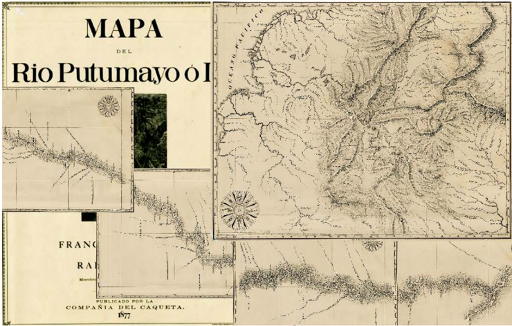
- Reyes’s 1877 map, *Mapa del rio Putumayo o Içá*, made with Francisco A. Bissau, has five sheets; its first sheet is a simplified copy of Codazzi’s 1865 map, while the other four detail the river, tributaries, lakes, islands, and riparian tribes, without marking borders or boundary disputes and without La Sofía or San José de Guamués.
- As president (1904–1909), Reyes divided the eight remaining departments into up to 34 new departments, signed modus vivendi with Peru in 1905 and 1906 recognizing the Putumayo as the border, and in 1907 signed a treaty with Brazil, represented by Barão do Rio Branco, which according to Andrade recovered Colombian navigation of the Caquetá and Putumayo; successors annulled his territorial dispositions and returned to the 1865 map.
Methods
- Historical reconstruction of 1874–1907 using Reyes’s *Memorias*, his 1901–1902 II Pan-American Conference report, Brazilian Hemeroteca Digital newspapers, Colombia’s *Diário Oficial*, Lemaitre’s biography, and works by Andrade, Villafañe, and Novak & Namihas.
- Cartographic comparison and proposed georeferencing of maps including Mosquera 1852, Codazzi 1865, Reyes/Bissau 1877, and Crevaux 1881.
- Chronological division into three periods: 1874–1884 explorations and boundary controversies; 1885–1904 withdrawal from the Amazon; 1904–1909 Reyes presidency, extended to the 1930s treaties.
Limitations
- The paper states that the chronology is difficult to organize because available data contain contradictions, including divergences between Reyes’s *Memorias* and his 1901–1902 account about the duration and timing of the first exploration; one newspaper source, *O Liberal do Pará* of 05/06/1875, is mutilated.
- It relies heavily on Reyes’s own memoirs and Lemaitre’s biography, and the author repeatedly frames key claims as hypotheses or research objectives rather than settled conclusions.
- Evident from the text: the cartographic georeferencing is presented as a future objective, and several causal claims about Reyes’s decisive impact on boundary outcomes remain to be fully demonstrated.
Model-written summary. Check it against the paper before relying on it.
Integrity signals
Registry
Cites
Statistics
Figures
Verification
Claims the paper makes
70 Own result · 37 Sources not found · 23 No basis given · 21 Own interpretation · 11 Not checked yet
None of the sources cited for this claim have been checked yet.
In the paper
“Em dezembro de 1876 o Globo publica documentos interessantes, dos quais pode deduzir-se que o Brasil tinha notificado ao Peru da «situação Reyes» com notas de 13 de agosto e 9 de setembro desse ano.”
hedged- Asserted: passes — The authors put it forward as true.
- Checkable: passes — It can be checked against evidence.
- Load-bearing: unclear — It is unclear whether the paper’s conclusions depend on it.
- Based: passes — The paper gives a reason why it holds.
A result the paper states — it cites no source for it, so there is none to check. The quote shows it is in the paper.
In the paper
“O governo colombiano demora-se até o 24 de novembro para emitir uma resposta, por sinal negativa, julgando os privilégios solicitados pela empresa dos irmãos Reyes como excessivos.”
plainstates a cause- Asserted: passes — The authors put it forward as true.
- Checkable: passes — It can be checked against evidence.
- Load-bearing: unclear — It is unclear whether the paper’s conclusions depend on it.
- Based: passes — The paper gives a reason why it holds.
In the paper
“centenares dos quais, milhares talvez, irão falecer por causa das febres.”
What the sources say
- Not matchedcites [39]
Couldn’t be matched to a paper in Crossref, so it can’t be checked.
hedgedstates a cause- Asserted: passes — The authors put it forward as true.
- Checkable: passes — It can be checked against evidence.
- Load-bearing: unclear — It is unclear whether the paper’s conclusions depend on it.
- Based: passes — The paper gives a reason why it holds.
- Not matched
A result the paper states — it cites no source for it, so there is none to check. The quote shows it is in the paper.
In the paper
“Neste período, conhecido como o «Quinquênio», Reyes promove uma radical reforma territorial da Colômbia, que, por um lado, incluía a divisão dos oito Departamentos tradicionais -Panamá acabava de declarar a sua separação-em trinta e quatro novas partes”
plainstates a cause- Asserted: passes — The authors put it forward as true.
- Checkable: passes — It can be checked against evidence.
- Load-bearing: unclear — It is unclear whether the paper’s conclusions depend on it.
- Based: passes — The paper gives a reason why it holds.
A result the paper states — it cites no source for it, so there is none to check. The quote shows it is in the paper.
In the paper
“a primeira folha do seu -que abrange os andes colombianos do sul desde o litoral do Pacífico até o nascimento dos rios Caquetá e Putumayo-, é uma cópia simplificada deste.”
plain- Asserted: passes — The authors put it forward as true.
- Checkable: passes — It can be checked against evidence.
- Load-bearing: passes — The paper’s conclusions depend on it.
- Based: passes — The paper gives a reason why it holds.
- It may state two separate claims as one. 91
- Probably not a substantial claim. 77
- The quote only partly states this claim. 3
Create a free account to see these claims.
Create a free account to see these assumptions.
31 more claims
Create a free account to see all 162 claims and every source verdict.
Self-check
Percentages, sums and reported differences re-computed from the paper’s own numbers.
Each contradiction between two passages listed here was confirmed by an independent check.
Rated minor: it would not touch a result — a value no result rests on, a p-value that stays on the same side of the significance level, or a conflict that is clerical, resolved elsewhere in the paper, or outside its own findings.
In the paper
§ Abstract
“a Colômbia negou a Reyes em 1874 as concessões que solicitava no sul do país”
§ Abstract
“com datas de 9 de dezembro de 1874 e 30 de abril de 1875, e provavelmente em contato com Rafael -pois, como vimos, aparentemente ele conseguia comunicar-se com cartas desde a floresta-, solicita ao governo colombiano concessões sobre estes territórios até o rio Napo”
Citations
Cites
Diving in magma: how to explore controversies with actor-network theory
Venturini, T. (2009) · Public Understanding of Science · doi:10.1177/0963662509102694 · Cited by 904
Gould, S. J. (1981) · DigitalGeorgetown (Georgetown University Library) · Cited by 888
Building on faults: How to represent controversies with digital methods
Venturini, T. (2010) · Public Understanding of Science · doi:10.1177/0963662510387558 · Cited by 371
Latour, B. (1998) · The Sociological Review · doi:10.1111/1467-954x.46.s.2 · Cited by 69
Latour, B. (2015) · Terra Brasilis · doi:10.4000/terrabrasilis.1308 · Cited by 15
Cintra, J. P., & Furtado, J. F. (2011) · Revista Brasileira de História · doi:10.1590/s0102-01882011000200015 · Cited by 11
Rafael Reyes : biografía de un gran colombiano
Lemaitre, E. (1981) · Banco de la República de Colombia eBooks · Cited by 7
Los diplomáticos colombianos y la nacionalización de la Amazonia
Becerra, G. C. (2007) · LA Referencia (Red Federada de Repositorios Institucionales de Publicaciones Científicas) · Cited by 6
Entrando em território arriscado
November, V., Camacho-Hübner, E., & Latour, B. (2013) · Terra Brasilis · doi:10.4000/terrabrasilis.903 · Cited by 5
Pinzón, F. M. (2013) · Anuario Colombiano de Historia Social y de la Cultura · Cited by 5
Territoire et réseau : une fausse dichotomie? = Territory and network : a false dichotomy?
Painter, J. (2009) · Durham Research Online (Durham University) · Cited by 4
Demarcación de las fronteras de Colombia
Goubert, L. L. (1966) · Revista de las Fuerzas Armadas · doi:10.25062/0120-0631.3122 · Cited by 2
Research works printed but not linked: 5
- ———. “La cartographie des controverses”. Technology Review, 2007, 82–83. http://palimpsestes.fr/textes_divers/la_cartographie_des_controverses.htm.
- ———. Reassembling the Social: An Introduction to Actor-Network-Theory. Oxford; New York: Oxford University Press, 2005.
- ———. We Have Never Been Modern. Traduzido por Catherine Porter. Harvard University Press, 1993.
- ———. “Le Fleuve des Amazones et ses affluents”. Bulletin de la Société de Géographie 6, no 12 (julho de 1876): 185–95. http://gallica.bnf.fr/ark:/12148/bpt6k377099/f186.
- ———. “Narrative of the journeys of exploration made by General Reyes and his brothers Nestor and Henry, in some regions of South America”. In Second International American Conference. México: 1901-1902. Organization of the Conference, Projects, Reports, Motions, Debates and Resolutions, 385–92. Mexico: Typographical department of Government printing office - National Palace, 1902. http://cdigital.dgb.uanl.mx/la/1080041848/1080041848.html.
Cited by
“Do Pacífico ao Atlântico pela parte mais larga do continente”
Palacios, D. A. R. (2020) · Terra Brasilis · doi:10.4000/terrabrasilis.6182 · Cited by 1
Self-citationSoto, P. C. (2022) · Cadernos de Tradução · doi:10.5007/2175-7968.2022.e90631
The conquest of the devil's paradise : international law, frontier-making and capitalist power
da Silva, F. A. M. (2022) · theses.fr (ABES) · doi:10.70675/1a1376b0z6f05z41c2za893zdc2602a5124c
Metadata
- Authors
- Palacios, D. R.
- Corresponding author
- Palacios, David Ramírez
- Venue
- Terra Brasilis
- Publisher
- OpenEdition
- Published
- 2015
- Volume
- 5
- ISSN
- 1519-1265 (ISSN-L)
- 2316-7793
- OpenAlex
- W2223378636
- Cited by
- 3
- References
- 14
- Citations by year
- 2022: 2 · 2020: 1
- FWCI
- 0.00
- Type
- journal article
- Language
- pt
- Open access
- diamond
- doi.org
- Licence
- cc-by-nc-sa
- Locations
- Terra Brasilis (publishedVersion, cc-by-nc-sa)
- DOAJ (DOAJ: Directory of Open Access Journals) (submittedVersion)
- OpenEdition (OpenEdition) (submittedVersion, other-oa)
- Topics
- Social Sciences › Arts and Humanities › History › History and Politics in Latin America
- Social Sciences › Arts and Humanities › History › Historical Studies in Latin America
- Social Sciences › Arts and Humanities › History › Travel Writing and Literature
- Keywords
- Rafael Reyes, Putumayo River, steam navigation, Amazon River, Pedro II, territorial reorganization, departmental division, Colombian civil war, Colombian presidency, 19th-century Colombia
About these checks
Registry, retraction, Cites and statistics results are computed, not judged, with one exception: a printed reference that no index lists is read once by a model before it counts as a citation error. Claims are extracted by a model and kept only when their quote appears verbatim in the text; each cited source is then checked, with a model’s help, for whether it says what the claim relies on. Those verdicts can be wrong — read the claim’s quote and the cited source before relying on one.
A language model drew the claims from the paper on 2026-11-08, under version 3 of the claim definition (model deepseek-v4.1-flash, prompt extract-v3).
A second model labelled each claim on 2026-11-08 (model jev-1.13-20260917, definition revision gold-guideline-v0.2).
Statistics and arithmetic are recomputed, not judged.
Confidence bands are shown only for fields calibrated on our annotated test set. None is calibrated yet, so no band is shown.
What counts as a claim ›How we measure confidence ›How we check this ›
Are you an author, or do you see a problem with this page? Request a review
