

The DOI matches its DataCite record.
A systematic review of geospatial location embedding approaches in large language models: A path to spatial AI systems
Open accessAbstract
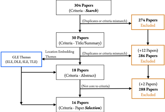
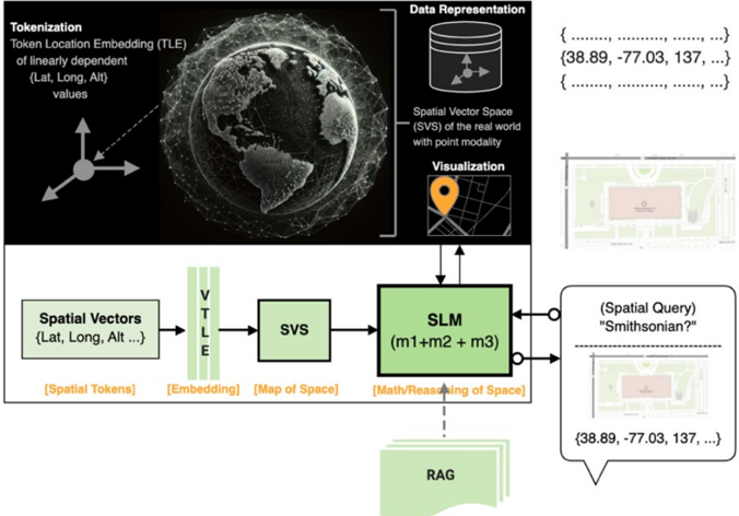
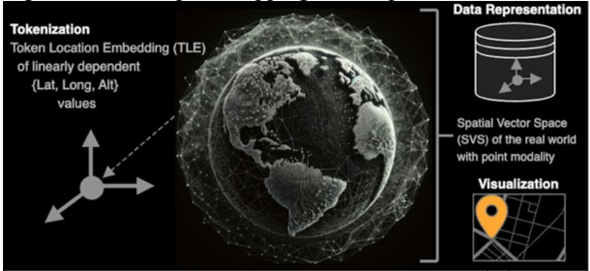
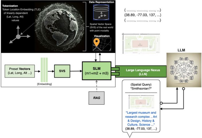
Geospatial Location Embedding (GLE) helps a Large Language Model (LLM) assimilate and analyze spatial data. GLE emergence in Geospatial Artificial Intelligence (GeoAI) is precipitated by the need for deeper geospatial awareness in our complex contemporary spaces and the success of LLMs in extracting deep meaning in Generative AI. We searched Google Scholar, Science Direct, and arXiv for papers on geospatial location embedding and LLM and reviewed articles focused on gaining deeper spatial "knowing" through LLMs. We screened 304 titles, 30 abstracts, and 18 full-text papers that reveal four GLE themes - Entity Location Embedding (ELE), Document Location Embedding (DLE), Sequence Location Embedding (SLE), and Token Location Embedding (TLE). Synthesis is tabular and narrative, including a dialogic conversation between "Space" and "LLM." Though GLEs aid spatial understanding by superimposing spatial data, they emphasize the need to advance in the intricacies of spatial modalities and generalized reasoning. GLEs signal the need for a Spatial Foundation/Language Model (SLM) that embeds spatial knowing within the model architecture. The SLM framework advances Spatial Artificial Intelligence Systems (SPAIS), establishing a Spatial Vector Space (SVS) that maps to physical space. The resulting spatially imbued Language Model is unique. It simultaneously represents actual space and an AI-capable space, paving the way for AI native geo storage, analysis, and multi-modality as the basis for Spatial Artificial Intelligence Systems (SPAIS).
Overview
The claims and statistics of this paper haven’t been checked yet.
Run the check — free, no account needed. It reads the open-access text and checks the sources it cites.
Integrity signals
Registry
Cites
Statistics
Figures
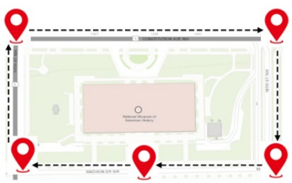
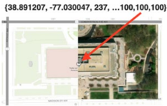
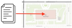
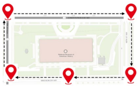
Verification
Claims the paper makes
The claims and statistics of this paper haven’t been checked yet.
Run the check — free, no account needed. It reads the open-access text and checks the sources it cites.
Claims other papers make about this one
Each is checked against this paper’s own text: does it say what the citing paper says it does?
The source backs part of the claim, not all of it — or backs it for a different population, condition or comparison.
In the citing paper
“Given its broad relevance in embodied interaction with the real physical world, spatial cognition has emerged as a central theme across disciplines, driving advances in robotics6, urban simulation7, and planetary-scale modeling8, while increasingly recognized as a foundational component of artificial general intelligence (AGI)3,9,10.”
From Brain-inspired spatial intelligence for embodied agents (2026) · cites this paper as [7]
Experimental — accuracy not yet measured
Self-check
Percentages, sums and reported differences re-computed from the paper’s own numbers.
The self-check needs the paper’s full text.
Citations
Cites
No references could be resolved yet.
Research works printed but not linked: 33
- Balsebre, P., Huang, W., Cong, G., Li, Y., 2023. CityFM: City foundation models to solve urban challenges. arXiv preprint arXiv:2310.00583. · arXiv
- Batty, M., Xie, Y., 1994. From cells to cities. Environment and Planning B, 21 (7), S31-S48.
- Batty, M., Xie, Y., Sun, Z., 1999. Modeling urban dynamics through GIS-based cellular automata. Computers, Environment and Urban Systems, 23 (3), 205-233.
- Benz, U.C., Hofmann, P., Willhauck, G., Lingenfelder, I., Heynen, M., 2004. Multi-resolution, object-oriented fuzzy analysis of remote sensing data for GIS-ready information. ISPRS Journal of Photogrammetry and Remote Sensing, 58 (3-4), 239-258.
- Bhandari, P., Anastasopoulos, A., Pfoser, D. 2023. Are large language models geospatially knowledgeable? arXiv. Cornell University.
- Brinkhoff, T., 2003. A portable SVG-viewer on mobile devices for supporting geographic applications. http://iapg.jade-hs.de/personen/brinkhoff/paper/AGILE2003.pdf. In Proceedings of the 6th Agile Conference on Geographic Information Science, Lyon, France (pp. 87-96).
- Das, S., 2023. Evaluating the capabilities of large language models for spatial and situational understanding Thesis (MA). University of Cambridge.
- Dunfey, R.I., Gittings, B.M., Batcheller, J.K., 2006. Towards an open architecture for vector GIS. Computers and Geosciences, 32 (10), 1720-1732.
- Fernandez, A., Dube, S., 2023. Core building blocks: Next gen geo spatial GPT application. arXiv. Cornell University.
- Goodchild, M.F., 2009. Geographic information systems and science: Today and tomorrow. Annals of GIS, 15 (1), 3-9.
- Han, Y., Liu, C., Wang, P., 2023. A comprehensive survey on vector database: Storage and retrieval technique, challenge. arXiv. Cornell University.
- Hu, Y., Mai, G., Cundy, C., Choi, K., Lao, N., Liu, W., Lakhanpal, G., Zhou, R.Z., Joseph, K., 2023. Geo-knowledge-guided GPT models improve the extraction of location descriptions from disaster-related social media messages. International Journal of Geographical Information Science, 37 (11), 2289-2318.
- Janowicz, K., Gao, S., McKenzie, G., Hu, Y., Bhaduri, B., 2020. GeoAI: Spatially explicit artificial intelligence techniques for geographic knowledge discovery and beyond. International Journal of Geographical Information Science, 34 (4), 625-636.
- Ji, Y., Gao, S., 2023. Evaluating the effectiveness of large language models in representing textual descriptions of geometry and spatial relations. arXiv. Cornell University.
- Jin, M., Wen, Q., Liang, Y., Zhang, C., Xue, S., Wang, H., Zhang, J., Hu, X., Chen, H., Li, X., Pan, S., Tseng, V.S., Zheng, Y., Chen, L., Xiong, H., 2023. Large models for time series and spatiotemporal data: A survey and outlook. arXiv (Cornell University).
- Kanwisher, N., 2010. Functional specificity in the human brain: A window into the functional architecture of the mind. Proceedings of the National Academy of Sciences of the United States of America, 107 (25), 11163-11170.
- Kuhn, W., 2012. Core concepts of spatial information for transdisciplinary research. International Journal of Geographical Information Science, 26 (12), 2267-2276.
- Li, Z., Zhou, W., Chiang, Y., Chen, M., 2023. GeoLM: Empowering Language Models for Geospatially Grounded Language Understanding. arXiv (Cornell University).
- Lin, J., Pradeep, R., Teofili, T., Xian, J., 2023. Vector search with OpenAI embeddings: Lucene is all you need. arXiv. Cornell University.
- Ling, C., Zhao, X., Lu, J., Deng, C., Zheng, C., Wang, J., Chowdhury, T., Li, Y., Cui, H., Zhang, X., Zhao, T., Panalkar, A., Cheng, W.S., Wang, H., Liu, Y., Chen, Z., Chen, H., White, C.M., Gu, Q., . . . Zhao, L., 2023. Domain specialization as the key to make large language models disruptive: A comprehensive survey. arXiv. Cornell University.
- Liu, P., Biljecki, F., 2022. A review of spatially explicit GeoAI applications in urban geography. International Journal of Applied Earth Observation and Geoinformation, 112, 102936.
- Luo, S., Ni, J., Chen, S., Rong, Y., Xie, Y., Liu, L., Jin, Z., Yao, H., Jia, X., 2023. The foundational semantic recognition for modeling environmental ecosystems. arXiv. Cornell University.
- Mai, G., Cundy, C., Choi, K., Hu, Y., Lao, N., Ermon, S., 2022. Towards a foundation model for geospatial artificial intelligence (vision paper). In Proceedings of the 30th International Conference on Advances in Geographic Information Systems, 1-4.
- Mai, G., Huang, W., Sun, J., Song, S., Mishra, D., Liu, N., Gao, S., Liu, T., Cong, G., Hu, Y., Cundy, C., Li, Z., Zhu, R., Lao, N., 2023. On the opportunities and challenges of foundation models for geospatial artificial intelligence. arXiv. Cornell University.
- Manvi, R.S., Khanna, S., Mai, G., Burke, M., Lobell, D.B., Ermon, S., 2023. GeoLLM: Extracting geospatial knowledge from large language models. arXiv. Cornell University.
- Mikolov, T., Chen, K., Corrado, G., Dean, J., 2013. Efficient estimation of word representations in vector space. arXiv. https://arxiv.org/pdf/1301.3781. Cornell University. · arXiv
- Openshaw, S., Openshaw, C., 1997. Artificial intelligence in geography. John Wiley & Sons, Inc.
- Saeedimoghaddam, M., Stepinski, T.F., 2020. Automatic extraction of road intersection points from USGS historical map series using deep convolutional neural networks. International Journal of Geographical Information Science, 34 (5), 947-968.
- Smith, T.R., 1984. Artificial intelligence and its applicability to geographical problem solving. Professional Geographer, 36 (2), 147-158.
- Unlu, E., 2023. Chatmap: Large Language Model interaction with cartographic data. arXiv. Cornell University.
- Xing, J., Sieber, R., 2023. The challenges of integrating explainable artificial intelligence into GeoAI. Transactions in GIS, 27 (3), 626-645.
- Yan, Y., Wen, H., Zhong, S., Chen, W., Chen, H., Wen, Q., Zimmermann, R., Liang, Y., 2023. When urban region profiling meets large language models. arXiv. Cornell University.
- Yin, Z., Li, D., Goldberg, D.W., 2023. Is ChatGPT a game changer for geocoding -a benchmark for geocoding address parsing techniques. In Proceedings of the 2nd ACM SIGSPATIAL International Workshop on Searching and Mining Large Collections of Geospatial Data (pp. 1-8).
Cited by
Sorted by citations
Brain-inspired spatial intelligence for embodied agents
Ruan, S., Wang, L., Kang, C., Zhu, Q., Liu, S., Wei, X., & Su, H. (2026) · Nature Communications · doi:10.1038/s41467-026-74358-5 · Cited by 1
Metadata
- Authors
- Tucker, S.
- Corresponding author
- Tucker, Sean
- ORCID
- Tucker, Sean
- Venue
- arXiv
- Publisher
- arXiv
- Published
- 2024
- ISSN
- 2331-8422 (ISSN-L)
- arXiv
- 2401.10279
- OpenAlex
- W4391125334
- Cited by
- 2
- References
- 0
- Citations by year
- 2026: 1 · 2024: 1
- FWCI
- 0.07
- Type
- journal article
- Language
- en
- Open access
- green
- arxiv.org
- Licence
- Locations
- arXiv (Cornell University) (submittedVersion, cc-by)
- arXiv (Cornell University) (cc-by)
- Topics
- Physical Sciences › Computer Science › Artificial Intelligence › Topic Modeling
- Social Sciences › Geography, Planning and Development › Geographic Information Systems Studies
- Physical Sciences › Computer Science › Information Systems › Data Management and Algorithms
- Keywords
- large language models, GeoAI, spatial data representation
About these checks
Registry, retraction, Cites and statistics results are computed, not judged, with one exception: a printed reference that no index lists is read once by a model before it counts as a citation error. Claims are extracted by a model and kept only when their quote appears verbatim in the text; each cited source is then checked, with a model’s help, for whether it says what the claim relies on. Those verdicts can be wrong — read the claim’s quote and the cited source before relying on one.
Statistics and arithmetic are recomputed, not judged.
Confidence bands are shown only for fields calibrated on our annotated test set. None is calibrated yet, so no band is shown.
What counts as a claim ›How we measure confidence ›How we check this ›
Are you an author, or do you see a problem with this page? Request a review
How to cite
Cite CoChat for the checks on this page, and the paper for its own findings.
- This page
- CoChat. (2026). Citation check: A systematic review of geospatial location embedding approaches in large language models: A path to spatial AI systems. https://app.cochat.ai/papers/10.48550/arxiv.2401.10279
- The paper
- Tucker, S. (2024). A systematic review of geospatial location embedding approaches in large language models: A path to spatial AI systems. arXiv. https://doi.org/10.48550/arxiv.2401.10279
