

The DOI matches its Crossref record; 27 of the 27 references it cites were found in a registry or an index; 3 of the 20 sources its claims cite were checked for support.
Probabilistic regression for autonomous terrain relative navigation via multi-modal feature learning
Open accessAbstract
The extension of human spaceflight across an ever-expanding domain, in conjunction with intricate mission architectures demands a paradigm shift in autonomous navigation algorithms, especially for the powered descent phase of planetary landing. Deep learning architectures have previously been explored to perform low-dimensional localization with limited success. Due to the expectations regarding novel algorithms in the context of real missions, the proposed approaches must be rigorously evaluated in extraneous scenarios and demonstrate sufficient robustness. In the current work, a novel formulation is proposed to train CNN-based Deep Learning (DL) models in a multi-layer cascading architecture and utilize the resulting classification probabilities as regression weights to estimate the position of the lander spacecraft. The approach leverages image intensity and depth data provided by multiple sensors on board to accurately determine the spacecraft’s location relative to the observed terrain at a specific altitude. Navigation performance is validated through Monte Carlo analysis, demonstrating the efficacy of the proposed DL architecture and the subsequent state-estimation framework across several simulated scenarios. It shows tremendous promise in extending the multi-modal feature learning approach to realistic missions.
Overview
CoChat Summary
TL;DR
The paper proposes a multi-modal cascading CNN that fuses image intensity and stereo-derived depth to perform terrain relative navigation, then converts classification probabilities into probabilistic position regression. In simulated lunar descent tests, the multi-modal model improves classification accuracy and regression robustness over uni-modal baselines, especially under low illumination and noisy depth.
Key findings
- At Level 1, test accuracy was 76.4% for intensity-only, 96.8% for depth-only, and 99.3% for intensity + depth.
- At Levels 2 and 3, the multi-modal CNN maintained accuracy above 98% and above 93%, respectively, while intensity-only accuracy dropped as low as 57.4% in one Level 2 quadrant.
- In severe tests, low-illumination intensity-only accuracy was 34.7%, noisy-depth-only was 52.3%, and combined low illumination + noisy depth was 65.0%; low illumination supplemented by depth reached 98.3%, and noisy depth with regular intensity reached 65.3%.
- Regression case at image center (200, 250) gave RMSE of 10.01 pixels (20.02 m) for Centered Prediction and 1.98 pixels (3.96 m) for Mean Neighborhood Prediction; a 2500-run Monte Carlo analysis reported state estimation errors of 14.43 pixels for Centered Prediction and 7.151 pixels for Mean Neighborhood Prediction.
Methods
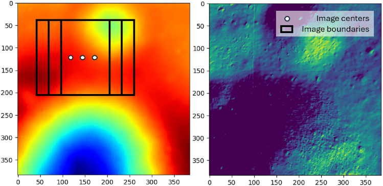
- The dataset was generated from the Apollo 16 Digital Terrain Model from the Lunar Reconnaissance Orbiter Camera, assuming nadir-pointed stereo images at 352 m altitude, with image windows of 32, 64, and 128 pixels across three cascading levels.
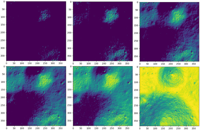
- Intensity maps were synthesized using Lambert’s cosine law; training used 10 azimuth/elevation combinations, while test data used 50 equally spaced elevation angles from 0 to 180 degrees, plus an extreme test set with 0–20 degree illumination and truncated Gaussian depth noise.
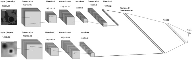
- The architecture used a Multi-Modal CNN with separate depth and intensity nodes, softmax classification, temperature scaling, and two probabilistic regression approaches: Centered Prediction and Mean Neighborhood Prediction, evaluated with RMSE and a 2500-run Monte Carlo analysis.
Limitations
- The paper states that the raw DTM resolution is a bottleneck and that higher-resolution DTMs would be needed to train models for lower altitudes.
- The paper notes that Mean Neighborhood Prediction is more accurate but computationally expensive: 3.58 s versus 0.266 s for Centered Prediction on an Intel i7-12700 and NVIDIA GeForce RTX 3070 Ti.
- The paper states that further research using real-life datasets is needed; evident from the text, all results are from simulated datasets, and the combined extreme case of low illumination plus noisy depth still achieved only 65.0% accuracy.
Model-written summary. Check it against the paper before relying on it.
Integrity signals
Registry
Cites
Statistics
Figures





Verification
Claims the paper makes
2 Valid · 3 Not valid · 12 Not checked · 50 Own results and interpretations
The cited sources support only part of this claim — read each source’s verdict below.
In the paper
“Feature matching algorithms that localize craters and other landmarks against known databases based only on optical inputs i.e., images experience extreme sensitivity to changes in illumination conditions, camera angle, and other numerical errors14,15.”
§ Probabilistic regression for autonomous terrain relative navigation via multi-modal feature learning > Introduction
What the sources say
- Partly supportedcites [14] Downes, L. et al. Lunar terrain relative navigation using a convolutional neural network for visual crater detection. In 2020 American Control Conference (ACC), 4448–4453 (2020). sourceExperimental — accuracy not yet measured
The Introduction reports that the traditional crater detector is sensitive to image quality, brightness, and shadowing, and that inaccurate position information can cause crater mismatches. The Simulation Results show false matches and estimation errors when image brightness changes. The paper does not establish sensitivity to camera angle or to numerical errors generally, and its matching system also uses a spacecraft position estimate rather than optical inputs alone. (LLM, conf=0.86)
- Not checked — no full text of the sourcecites [15] Mourikis, A. et al. Vision-aided inertial navigation for spacecraft entry, descent, and landing. IEEE Trans. Rob. 25, 264–280 (2009). source
plainstates a cause- Asserted: passes — The authors put it forward as true.
- Checkable: passes — It can be checked against evidence.
- Load-bearing: passes — The paper’s conclusions depend on it.
- Based: passes — The paper gives a reason why it holds.
- Partly supported
A result the paper states — it cites no source for it, so there is none to check. The quote shows it is in the paper.
In the paper
“The proposed model— (1) improves test accuracy, (2) leverages classification probabilities to localize the spacecraft, and (3) improves robustness and generalizability during realistic mission scenarios.”
§ Probabilistic regression for autonomous terrain relative navigation via multi-modal feature learning > Introduction
plainstates a cause- Asserted: passes — The authors put it forward as true.
- Checkable: passes — It can be checked against evidence.
- Load-bearing: passes — The paper’s conclusions depend on it.
- Based: passes — The paper gives a reason why it holds.
- Rests on 2 assumptions not shown here.
A result the paper states — it cites no source for it, so there is none to check. The quote shows it is in the paper.
In the paper
“With the help of simulated scenarios, it is conclusively demonstrated that the inferior performance, especially in low-illumination conditions of the classification-only cascading CNN model, can be significantly improved by leveraging features from both modalities during training.”
§ Probabilistic regression for autonomous terrain relative navigation via multi-modal feature learning > Introduction
boostedstates a cause- Asserted: passes — The authors put it forward as true.
- Checkable: passes — It can be checked against evidence.
- Load-bearing: passes — The paper’s conclusions depend on it.
- Based: passes — The paper gives a reason why it holds.
- Rests on 5 assumptions not shown here.
A result the paper states — it cites no source for it, so there is none to check. The quote shows it is in the paper.
In the paper
“For the examples discussed earlier, despite achieving an impressive accuracy on the test set, the model often exhibited a tendency to assign excessively high probabilities to its predictions, especially for challenging or ambiguous samples.”
§ Probabilistic regression for autonomous terrain relative navigation via multi-modal feature learning > Methodology > Regression
plainstates an association- Asserted: passes — The authors put it forward as true.
- Checkable: passes — It can be checked against evidence.
- Load-bearing: passes — The paper’s conclusions depend on it.
- Based: passes — The paper gives a reason why it holds.
The paper states this without a source or data behind it here, so there is nothing to check it against. The quote shows it is in the paper.
In the paper
“A probabilistic regression scheme leveraging cumulative classification probability densities across the cascading layers is proposed instead, and shown to demonstrate consistent performance over the entire domain ().”
§ Probabilistic regression for autonomous terrain relative navigation via multi-modal feature learning > Methodology
boostedstates a cause- Asserted: passes — The authors put it forward as true.
- Checkable: passes — It can be checked against evidence.
- Load-bearing: passes — The paper’s conclusions depend on it.
- Based: unclear — It is unclear why the paper says it holds.
- Rests on 2 assumptions not shown here.
21 more claims
Create a free account to see all 67 claims and to verify the 2 references still open.
- Probably not a substantial claim. 17
- It may state two separate claims as one. 29
- The quote only partly states this claim. 3
Self-check
Percentages, sums and reported differences re-computed from the paper’s own numbers.
Each contradiction between two passages listed here was confirmed by an independent check.
Rated minor: it would not touch a result — a value no result rests on, a p-value that stays on the same side of the significance level, or a conflict that is clerical, resolved elsewhere in the paper, or outside its own findings.
In the paper
§ Probabilistic regression for autonomous terrain relative navigation via multi-modal feature learning > Methodology > Dataset generation
“In this study, sampling locations are spaced with increments of 2, 4, and 8 for window sizes 128, 64, and 32, respectively to generate an equivalent number of images for each sub-category.”
§ Probabilistic regression for autonomous terrain relative navigation via multi-modal feature learning > Methodology > Multi-modal cascading CNN architecture
“For instance, 128-pixel resolution depth images are generated with an 8-pixel increment, restricting the size of the training dataset to samples.”
Citations
Cites
Journal of Guidance, Control, and Dynamics
(2021) · doi:10.2514/jgcd · Cited by 2,007
Stochastic Gradient Learning in Neural Networks
Bottou, L. (1991) · Cited by 584
The Artemis Program: An Overview of NASA's Activities to Return Humans to the Moon
Smith, M., Craig, D., Herrmann, N., Mahoney, E., Krezel, J., McIntyre, N., & Goodliff, K. (2020) · 2020 IEEE Aerospace Conference · doi:10.1109/aero47225.2020.9172323 · Cited by 363
Vision-Aided Inertial Navigation for Spacecraft Entry, Descent, and Landing
Mourikis, A. I., Trawny, N., Roumeliotis, S. I., Johnson, A. E., Ansar, A., & Matthies, L. (2009) · IEEE Transactions on Robotics · doi:10.1109/tro.2009.2012342 · Cited by 345 · cited 1×
“Feature matching algorithms that localize craters and other landmarks against known databases based only on optical inputs i.e., images experience extreme sensitivity to changes in illumination conditions, camera angle, and other numerical errors 14,15 .”
An overview of the Mars Reconnaissance Orbiter (MRO) science mission
Zurek, R. W., & Smrekar, S. E. (2007) · Journal of Geophysical Research: Planets · doi:10.1029/2006je002701 · Cited by 307 · cited 1×
“…of TRN, training of deep learning models can be performed from data prepared from planetary reconnaissance missions, such as the Lunar Reconnaissance Orbiter (LRO), which captured the lunar surface at a resolution of approximately one meter per pixel 12 or the Mars Reconnaissance Orbiter (MRO) 13 .”
3D Convolutional Neural Networks for landing zone detection from LiDAR
Maturana, D., & Scherer, S. (2015) · 2015 IEEE International Conference on Robotics and Automation (ICRA) · doi:10.1109/icra.2015.7139679 · Cited by 203 · cited 1×
“Real and simulated LiDAR data has proven efficient and robust data for neural network training in many applications, such as obstacle detection 20 , path planning 21 , and TRN even in the case of uncooperative operations 22 .”
AIAA Space 2001 Conference and Exposition
(2001) · doi:10.2514/mspace01 · Cited by 126
Optical Navigation Using Planet’s Centroid and Apparent Diameter in Image
Christian, J. A. (2014) · Journal of Guidance Control and Dynamics · doi:10.2514/1.g000872 · Cited by 119
Adaptive guidance and integrated navigation with reinforcement meta-learning
Gaudet, B., Linares, R., & Furfaro, R. (2020) · Acta Astronautica · doi:10.1016/j.actaastro.2020.01.007 · Cited by 111 · cited 1×
“Other works have explored the use of Reinforcement Learning (RL) for autonomous planetary landing 27,28 .”
Eclipse-Conscious Transfer to Lunar Gateway Using Ephemeris-Driven Terminal Coast Arcs
Singh, S. K., Junkins, J. L., Anderson, B. D. O., et al. (2021) · Journal of Guidance Control and Dynamics · doi:10.2514/1.g005920 · Cited by 54
Self-citation
Research works printed but not linked: 5
- Esty, C. C., Lee, D., Martinez, R. & McCarthy, B. Assessment of cislunar staging orbits to support the artemis iii lunar surface mission. In 45th Annual AAS Guidance, Navigation and Control (GN &C) Conference, AAS 22-762 (2023).
- Bussey, B., Clarke, S. W., Jenkins, J. & Bailey, B. E. Nasa’s lunar discovery and explorartion program. In AGU Fall Meeting Abstracts, vol. 2019, PA54B–11 (2019).
- Bhaskaran, S. & Hopkins, J. Astrobotic: Peregrine lunar lander technical program update. In 2017 Annual Meeting of the Lunar Exploration Analysis Group, vol. 2041, 5019 (2017).
- Sternberg, D. C., Setterfield, T. P., Bailey, E. S., Ansar, A. I. & Johnson, A. E. Demonstration of stereo vision for deorbit descent and landing. vol. 169. Binocular stereo vision system; Flight systems; Landing accuracy; Post processing; Ranging accuracy; Relative navigation; Sensing modalities; Visual odometry, 161–172 (Breckenridge, CO, United states, 2019).
- Campbell, T., Furfaro, R., Linares, R. & Gaylor, D. A deep learning approach for optical autonomous planetary relative terrain navigation. Spacefl. Mech. 160, 3293–3302 (2017).
Cited by
Labò, S. G., Silvestrini, S., & Lavagna, M. R. (2025) · Advances in Space Research · doi:10.1016/j.asr.2025.09.048 · Cited by 1
Optimal Control and Neural Porkchop Analysis for Low-Thrust Asteroid Rendezvous Mission
Zhang, Z., Michelotti, N., Pinho, G. O., et al. (2026) · Astronautics · doi:10.3390/astronautics1010006
“Machine learning models have also been employed for real-time trajectory guidance [26–29].”
Koushafar, M., & Kosari, A. (2026) · Acta Astronautica · doi:10.1016/j.actaastro.2026.07.027 · Cited by 1
MALS-Net: a multimodal attention-enhanced segmentation network for detecting lunar lobate scarps
Li, X., Peng, M., Di, K., Xie, B., Liu, B., Wang, B., Li, L., Zhang, S., & Liu, J. (2026) · Geo-spatial Information Science · doi:10.1080/10095020.2026.2728348 · Cited by 1
Metadata
- Authors
- Kim, I., & Singh, S.
- Affiliations
- Rensselaer Polytechnic Institute (US)
- Venue
- Scientific Reports
- Published
- 2024-12-02
- Volume
- 14
- Issue
- 1
- Pages
- 29966-29966
- ISSN
- 2045-2322 (ISSN-L)
- PMC
- PMC11612231
- OpenAlex
- W4404918570
- Cited by
- 6
- References
- 26
- Citations by year
- 2026: 4 · 2025: 2
- FWCI
- 1.03
- Type
- journal article
- Language
- en
- Open access
- gold
- doi.org
- Licence
- cc-by
- creativecommons.org/licenses/by/4.0 (tdm)
- creativecommons.org/licenses/by/4.0 (vor)
- Locations
- Scientific Reports (publishedVersion, cc-by)
- Research Square (acceptedVersion, cc-by)
- PubMed Central (publishedVersion, cc-by)
- PubMed (publishedVersion)
- DOAJ (DOAJ: Directory of Open Access Journals) (submittedVersion, cc-by-sa)
- Funders
- Rensselaer Polytechnic Institute
- Topics
- Physical Sciences › Engineering › Aerospace Engineering › Spacecraft Dynamics and Control
- Physical Sciences › Computer Science › Computer Vision and Pattern Recognition › Robotics and Sensor-Based Localization
- Physical Sciences › Computer Science › Artificial Intelligence › Reinforcement Learning in Robotics
- Keywords
- terrain relative navigation, autonomous navigation, planetary landing, powered descent, probabilistic regression, convolutional neural networks, state estimation, Monte Carlo simulation
About these checks
Registry, retraction, Cites and statistics results are computed, not judged, with one exception: a printed reference that no index lists is read once by a model before it counts as a citation error. Claims are extracted by a model and kept only when their quote appears verbatim in the text; each cited source is then checked, with a model’s help, for whether it says what the claim relies on. Those verdicts can be wrong — read the claim’s quote and the cited source before relying on one.
The claim verdicts this report counts are experimental: their accuracy is not yet measured.
A language model drew the claims from the paper on 2026-10-10, under version 3 of the claim definition (model deepseek-v4.1-flash, prompt extract-v3).
A second model labelled each claim on 2026-10-10 (model jev-1.13-20260917, definition revision gold-guideline-v0.2).
Cited sources are checked with a language model’s help (gpt-6-sol).
Statistics and arithmetic are recomputed, not judged.
Confidence bands are shown only for fields calibrated on our annotated test set. None is calibrated yet, so no band is shown.
What counts as a claim ›How we measure confidence ›How we check this ›
Are you an author, or do you see a problem with this page? Request a review
How to cite
Cite CoChat for the checks on this page, and the paper for its own findings.
- This page
- CoChat. (2026). Citation check: Probabilistic regression for autonomous terrain relative navigation via multi-modal feature learning. https://app.cochat.ai/papers/10.1038/s41598-024-81377-z
- The paper
- Kim, I., & Singh, S. (2024). Probabilistic regression for autonomous terrain relative navigation via multi-modal feature learning. Scientific Reports. https://doi.org/10.1038/s41598-024-81377-z
Data sources
Bibliographic data: Semantic Scholar, OpenAlex, Crossref.
Contains information from the Semantic Scholar Academic Graph Datasets, made available under the ODC Attribution License (ODC-BY 1.0).
Semantic Scholar’s data is described in: Kinney, R., et al. (2023). The Semantic Scholar Open Data Platform. arXiv:2301.10140.
