

Integrated Imaging Mission Planning Modeling Method for Multi-Type Targets for Super-Agile Earth Observation Satellite
Open accessThe DOI matches its Crossref record; 28 of the 30 references it cites were found in a registry or an index; 4 of the 30 sources its claims cite were checked for support.
Abstract
A unified description in the imaging mission of different types of targets is lacking, making overall optimization of imaging missions of complex multi-type targets (point, curve, and area) within a single pass difficult when using traditional satellite imaging mission planning.
Overview
CoChat Summary
TL;DR
The paper proposes an optimal mission decomposition/merge (MD/M) strategy and integrated planning model to schedule point, curve, and area targets in a single pass of a super-agile Earth observation satellite. In seven simulated multi-type scenarios, the method achieved 100% imaging coverage benefit and reduced optimization time compared with independent planning, with mission execution times varying by scenario.
Key findings
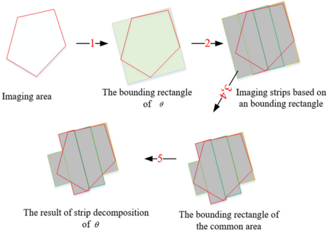
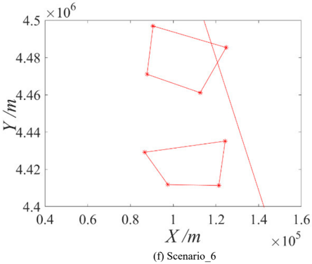
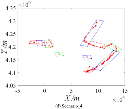
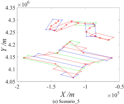
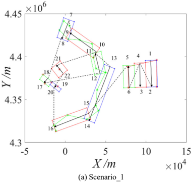
- The optimal MD/M strategy uniformly converts point, curve, and area targets into atomic strip tasks that are not parallel to the sub-satellite track, overcoming traditional parallel-strip decomposition for SA-EOS dynamic imaging.
- Across seven scenarios, imaging coverage benefit (ICB) was 100% for worst, average, and optimal runs; e.g., Scenario_1 mission execution time (MET) was 20.179 s / 19.449 s / 19.061 s, and Scenario_7 was 25.621 s / 24.232 s / 22.774 s (Table IV).
- Integrated planning versus independent planning achieved 100% ICB in all scenarios; MET differences ranged from −4.363 s (−18.32%) in Scenario_1 to +1.76 s (+7.83%) in Scenario_7, while time consumption of optimization (TCO) decreased in all comparisons, e.g., −776.19 s (−20.95%) in Scenario_1 and −1217.56 s (−39.64%) in Scenario_2 (Table V).
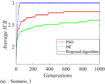
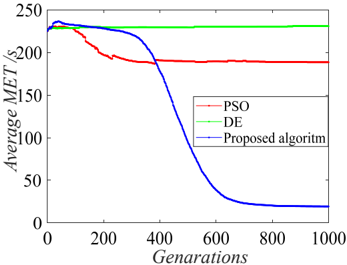
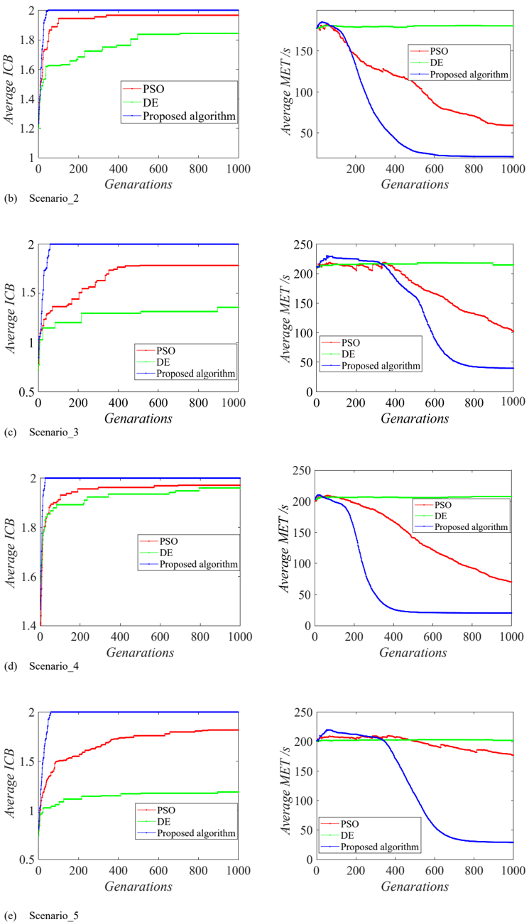
- The improved PSO algorithm with real and binary decision variables gave higher average ICB and lower average MET than PSO and DE over 10 optimizations (Fig. 12).
Methods
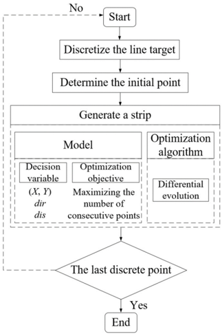
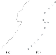
- Two-stage optimization: first, optimal MD/M preprocessing—area target strip decomposition optimized by differential evolution (DE) to minimize strip length sum; point targets clustered by DBSCAN with eps = D and minpts = 2 and then decomposed; curve target segmented greedily with DE to maximize consecutive points covered per strip.
- Second, an integrated planning model uses decision variables p (strip imaging sequence), qj (strip imaging direction), and tk (normalized imaging time); objectives maximize ICB (higher priority) and minimize MET; constraints are imaging time window and attitude transition time; solved by improved PSO with real and binary updating strategies.
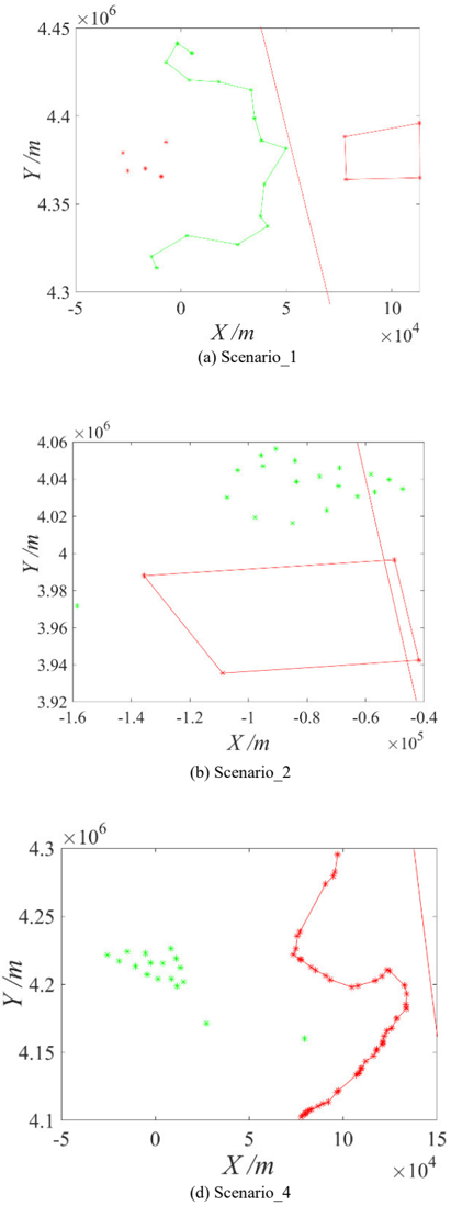
- Simulation used satellite parameters (orbit semi-major axis 6878.14 km, inclination 97.4065°, maximum maneuvering angle 60°, angular velocity 6°/s, field of view 1.6°, start time 2019-5-19-04:33:00.000) and seven multi-type target scenarios; DE population size 100 and 500 iterations, PSO population size 100 and 1000 iterations, each optimized 10 times.
Limitations
- Stated assumptions: on-board memory and energy were assumed sufficient; sun elevation was assumed to satisfy optical imaging requirements; the imaging mission was observed within a single pass; the maximum desired number of observations for one atomic task was one; each atomic task had the same weight (Section IV.A).
- Evident from the text: validation is limited to simulation experiments with seven scenarios and 10 optimization runs; no real satellite or operational data validation is reported.
- Evident from the text: the paper does not provide an explicit limitations section or discuss generalizability beyond the tested target combinations and satellite parameter set.
Model-written summary. Check it against the paper before relying on it.
Integrity signals
Registry
Cites
Statistics
Figures















Verification
Claims the paper makes
1 Valid · 2 Not valid · 15 Not checked · 49 Own results and interpretations
A result the paper reports from its own data — it cites no other source for it, so there is none to check. The quote shows it is in the paper.
In the paper
“As shown in Table IV and Fig. 11, the imaging coverage benefit of the 10 optimization results for the seven group imaging missions was 100%.”
- Also stated in: § C. Results of Mission Planning · plain
“the imaging coverage benefit of the 10 optimization results for the seven group imaging missions was 100%”
§ Integrated imaging mission planning modeling method for multi-type targets for super-agile earth observation satellite > C. Results of Mission Planning
plain- Asserted: passes — The authors put it forward as true.
- Checkable: passes — It can be checked against evidence.
- Load-bearing: passes — The paper’s conclusions depend on it.
- Based: passes — The paper gives a reason why it holds.
- Also stated in: § C. Results of Mission Planning · plain
The paper states this without a source or data behind it here, so there is nothing to check it against. The quote shows it is in the paper.
In the paper
“After preprocessing, an integrated imaging mission planning model was proposed for integrated scheduling for the imaging mission of complex multi-type targets within a single pass of the SA-EOS, which achieved the optimal overall observation benefit.”
§ Integrated imaging mission planning modeling method for multi-type targets for super-agile earth observation satellite > I. INTRODUCTION
plainstates a cause- Asserted: passes — The authors put it forward as true.
- Checkable: passes — It can be checked against evidence.
- Load-bearing: passes — The paper’s conclusions depend on it.
- Based: unclear — It is unclear why the paper says it holds.
- Rests on 5 assumptions not shown here.
A result the paper reports from its own data — it cites no other source for it, so there is none to check. The quote shows it is in the paper.
In the paper
“with a difference in the mission execution time of the modeling method of approximately ±4 s (approximately -26 -3%) compared with the sum of the mission execution time from the separate modeling of different types of targets.”
§ Integrated imaging mission planning modeling method for multi-type targets for super-agile earth observation satellite > D. Experimental Analysis
plain- Asserted: passes — The authors put it forward as true.
- Checkable: passes — It can be checked against evidence.
- Load-bearing: passes — The paper’s conclusions depend on it.
- Based: passes — The paper gives a reason why it holds.
A result the paper reports from its own data — it cites no other source for it, so there is none to check. The quote shows it is in the paper.
In the paper
“Table V shows that the modeling method used in this study achieved a 100% imaging coverage benefit in all seven scenarios”
§ Integrated imaging mission planning modeling method for multi-type targets for super-agile earth observation satellite > D. Experimental Analysis
plainstates a cause- Asserted: passes — The authors put it forward as true.
- Checkable: passes — It can be checked against evidence.
- Load-bearing: passes — The paper’s conclusions depend on it.
- Based: passes — The paper gives a reason why it holds.
A result the paper reports from its own data — it cites no other source for it, so there is none to check. The quote shows it is in the paper.
In the paper
“Overall, 1) the proposed optimal MD/M strategy effectively preprocesses imaging missions of multi-type targets and 2) the proposed optimal MD/M strategy overcomes the limitations of the traditional strip decomposition method, which is parallel to the sub-satellite track, and achieves the dynamic imaging of the SA-EOS.”
§ Integrated imaging mission planning modeling method for multi-type targets for super-agile earth observation satellite > B. Preprocessing Results of Optimal MD/M Strategy
plainstates a cause- Asserted: passes — The authors put it forward as true.
- Checkable: passes — It can be checked against evidence.
- Load-bearing: passes — The paper’s conclusions depend on it.
- Based: passes — The paper gives a reason why it holds.
- Rests on an assumption not shown here.
33 more claims
Create a free account to see all 67 claims and every source verdict.
- Probably not a substantial claim. 7
- It may state two separate claims as one. 22
Self-check
Percentages, sums and reported differences re-computed from the paper’s own numbers.
Each contradiction between two passages listed here was confirmed by an independent check.
Rated minor: it would not touch a result — a value no result rests on, a p-value that stays on the same side of the significance level, or a conflict that is clerical, resolved elsewhere in the paper, or outside its own findings.
In the paper
§ Integrated imaging mission planning modeling method for multi-type targets for super-agile earth observation satellite > C. Results of Mission Planning
“Scenario_3 ICB 100 % 100 % 100 % MET 40.354 s 39.828 s 39.466 s”
§ Integrated imaging mission planning modeling method for multi-type targets for super-agile earth observation satellite > VI. CONCLUSION
“Scenario_3 Independent planning line 100 % 10.128 s 1439.89s area 100 % 28.524 s 2843.73 s Integrated planning line + area 100 % 38.828 s 3657.45 s”
Citations
Cites
Storn, R., & Price, K. (1997) · Journal of Global Optimization · doi:10.1023/a:1008202821328 · Cited by 29,569
(1996) · Cited by 20,179
A discrete binary version of the particle swarm algorithm
Kennedy, J., & Eberhart, R. C. (2002) · 1997 IEEE International Conference on Systems, Man, and Cybernetics. Computational Cybernetics and Simulation · doi:10.1109/icsmc.1997.637339 · Cited by 4,767
Selecting and scheduling observations of agile satellites
Lemaı̂tre, M., Verfaillie, G., Jouhaud, F., Lachiver, J.-M., & Bataille, N. (2002) · Aerospace Science and Technology · doi:10.1016/s1270-9638(02)01173-2 · Cited by 472
Peng, G., Dewil, R., Verbeeck, C., Gunawan, A., Xing, L., & Vansteenwegen, P. (2019) · Computers & Operations Research · doi:10.1016/j.cor.2019.05.030 · Cited by 113
Chang, Z., Chen, Y., Yang, W., & Zhou, Z. (2020) · Advances in Space Research · doi:10.1016/j.asr.2020.09.002 · Cited by 72
Self-citation(2005) · Cited by 38
Agile Satellite Mission Planning Via Task Clustering and Double-Layer Tabu Algorithm
Zhao, Y., Du, B., & Li, S. (2020) · Computer Modeling in Engineering & Sciences · doi:10.32604/cmes.2020.08070 · Cited by 34
Lu, Z., Shen, X., Li, D., Chen, Y., & Li, D. (2022) · IEEE Systems Journal · doi:10.1109/jsyst.2021.3072122 · Cited by 24
Self-citationAn Efficient Local Search Heuristic for Earth Observation Satellite Integrated Scheduling
Chen, Y., Lu, J., He, R., & Ou, J. (2020) · Applied Sciences · doi:10.3390/app10165616 · Cited by 24
Self-citation
Research works printed but not linked: 21
- Gao, 2021, Agile satellite autonomous observation mission planning using hybrid genetic algorithm, J. Harbin Inst. Technol., 53, 1
- Hu, 2021, Application of GFDM-1 satellite in flood disaster monitoring, Spacecraft Eng., 30, 218
- Wang, 2017, Design and research of smart multi-mode imaging for agile satellite
- Li, 2018, Research On Key Technologies of Agile Satellite Imaging Mission Planning Model
- Geng, 2020, Optimal mission planning with task clustering for intensive point targets observation of staring mode agile satellite, Control Decis., 35, 613
- Lin, 2014, Mission planning method for agile optical satellite in dense area push-scan imaging, Chin. Space Sci. Technol., 34, 62
- Yu, 2015, Study of one-orbit multi-stripes splicing imaging for agile satellite, Spacecraft Eng., 24, 27
- Li, 2019, Optimization of lateral swing angles of lunar satellite for region multiple strip imaging task planning, Geomatics Inf. Sci. Wuhan Univ., 44, 593
- Gan, 2021, Observation mission planning for maneuverable satellite constellation towards multiple area targets, J. Astronaut., 42, 185
- Yang, 2016, Area target oriented non-along-with-track strip partitioning method for agile satellite, Sci. Technol. Eng., 16, 82
- Yang, 2009, Research on Imaging Scheduling Method of Earth Observation Satellite Based on Area Target Decomposition
- Pan, 2017, Dynamic segmenting method of polygon target based on FOV for remote sensing satellite imaging, Spacecraft Eng., 26, 38
- Jaubert, Attitude guidance technics developed in CNES for earth observation and scientific missions, 1
- Lohr, Automated planning for earth observation spacecraft under attitude dynamical constraints, 1
- Huang, Study on track planning of dynamic push-scan in agile satellite
- Yu, 2019, Design of agile satellites active scanning imaging mode on general track, Spacecraft Eng., 28, 27
- Dong, 2017, Research on Multi-Type Task Combination Scheduling Method of Optical Imaging Agile Satellite
- Zhai, 2021, A radar plot processing method based on DBSCAN clustering, Shipboard Electron. Countermeasure, 44, 58
- Zhao, 2013, Douglas-puke compression with automatic threshold setting, J. Shanxi Inst. Energy, 26, 120
- Shen, 2018, An optimization design method for high temporal resolution remote sensing satellite constellation based on improved PSO algorithm, Geomatics Inf. Sci. Wuhan Univ., 43, 1986
- Bi, 2012, DBSCAN: Density-based spatial clustering of applications with noise, J. Nanjing Univ. (Nat. Sci.), 48, 491
Cited by
Zhou, D., Sheng, M., Bao, C., Wang, Y., Li, J., & Han, Z. (2025) · IEEE Transactions on Communications · doi:10.1109/tcomm.2025.3529250 · Cited by 48
Wu, G., Xiang, Z., Wang, Y., Gu, Y., & Witold Pedrycz, C. (2024) · IEEE Transactions on Aerospace and Electronic Systems · doi:10.1109/taes.2024.3416427 · Cited by 47
Multiple super-agile satellite collaborative mission planning for area target imaging
Lu, Z., Shen, X., Li, D., Li, D., Chen, Y., Wang, D., & Shen, S. (2023) · International Journal of Applied Earth Observation and Geoinformation · doi:10.1016/j.jag.2023.103211 · Cited by 48
Self-citationLu, W., Gao, W., Liu, B., Niu, W., Peng, X., Yang, Z., & Song, Y. (2024) · Advances in Space Research · doi:10.1016/j.asr.2024.07.044 · Cited by 26
A mission planning method for deep space detectors using deep reinforcement learning
Qi, Y., Gu, D., Liu, Y., Zhu, J., Wang, J., & Liu, D. (2024) · Aerospace Science and Technology · doi:10.1016/j.ast.2024.109417 · Cited by 24
Metadata
- Authors
- Lu, Z., Shen, X., Li, D., & Chen, Y.
- Affiliations
- Wuhan University (CN)
- Venue
- IEEE Journal of Selected Topics in Applied Earth Observations and Remote Sensing
- Published
- 2022
- Volume
- 15
- Pages
- 4156-4169
- ISSN
- 1939-1404 (ISSN-L)
- 2151-1535
- OpenAlex
- W4285251417
- Semantic Scholar
- 26d51dfd19a9c038a1b1b0993207f41051edb291
- Cited by
- 29
- References
- 30
- Citations by year
- 2026: 4 · 2025: 11 · 2024: 10 · 2023: 4
- FWCI
- 3.03
- Type
- journal article
- Language
- en
- Open access
- gold
- doi.org
- Locations
- IEEE Journal of Selected Topics in Applied Earth Observations and Remote Sensing (publishedVersion, cc-by)
- DOAJ (DOAJ: Directory of Open Access Journals) (submittedVersion)
- Funders
- National Natural Science Foundation of China (42171341)
- Topics
- Physical Sciences › Computer Science › Computer Vision and Pattern Recognition › Satellite Image Processing and Photogrammetry
- Physical Sciences › Engineering › Aerospace Engineering › Satellite Communication Systems
- Physical Sciences › Engineering › Aerospace Engineering › Spacecraft Dynamics and Control
- Keywords
- dynamic imaging, particle swarm optimization
About these checks
Registry, retraction, Cites and statistics results are computed, not judged, with one exception: a printed reference that no index lists is read once by a model before it counts as a citation error. Claims are extracted by a model and kept only when their quote appears verbatim in the text; each cited source is then checked, with a model’s help, for whether it says what the claim relies on. Those verdicts can be wrong — read the claim’s quote and the cited source before relying on one.
The claim verdicts this report counts are experimental: their accuracy is not yet measured.
A language model drew the claims from the paper on 2026-10-10, under version 3 of the claim definition (model deepseek-v4.1-flash, prompt extract-v3).
A second model labelled each claim on 2026-10-10 (model jev-1.13-20260917, definition revision gold-guideline-v0.2).
Statistics and arithmetic are recomputed, not judged.
Confidence bands are shown only for fields calibrated on our annotated test set. None is calibrated yet, so no band is shown.
What counts as a claim ›How we measure confidence ›How we check this ›
Are you an author, or do you see a problem with this page? Request a review
How to cite
Cite CoChat for the checks on this page, and the paper for its own findings.
- This page
- CoChat. (2026). Citation check: Integrated Imaging Mission Planning Modeling Method for Multi-Type Targets for Super-Agile Earth Observation Satellite. https://app.cochat.ai/papers/10.1109/jstars.2022.3176951
- The paper
- Lu, Z., Shen, X., Li, D., & Chen, Y. (2022). Integrated Imaging Mission Planning Modeling Method for Multi-Type Targets for Super-Agile Earth Observation Satellite. IEEE Journal of Selected Topics in Applied Earth Observations and Remote Sensing. https://doi.org/10.1109/jstars.2022.3176951
Data sources
Bibliographic data: Semantic Scholar, OpenAlex, Crossref.
Contains information from the Semantic Scholar Academic Graph Datasets, made available under the ODC Attribution License (ODC-BY 1.0).
Semantic Scholar’s data is described in: Kinney, R., et al. (2023). The Semantic Scholar Open Data Platform. arXiv:2301.10140.
