

The DOI matches its Crossref record; 74 of the 82 references it cites were found in a registry or an index, and 8 are not checked yet; none of the 84 sources its claims cite is checked for support yet.
Spatio-temporal volume recalibration shows Deccan volcanism caused Terminal Cretaceous Mass Extinction
Open accessAbstract
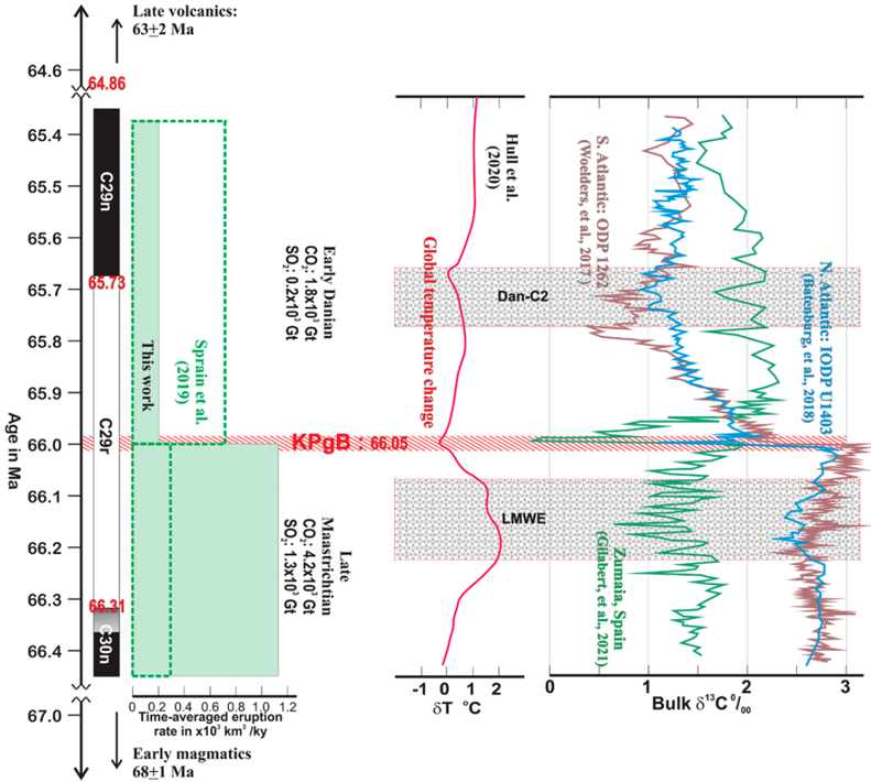
The recognition of Deccan flood basalts as a causal mechanism for the Terminal Cretaceous Mass Extinction has been contentious. Our computation of their spatio-temporal distribution reiterates that ~1.5 million km3 of the Deccan flood basalts erupted in <700 k.y., during Chron C29r (66.31–65.73 Ma) straddling the 66.05 Ma Cretaceous-Paleogene boundary (KPgB). Unlike earlier projections, we demonstrate that ~70% of these lavas erupted in the terminal Maastrichtian before the KPgB. The toxic degassing of the lavas in the ~300 k.y. prior to the KPgB set the stage for mass extinction. The early Danian lavas contributed to the delayed biotic recovery.
Checked 2026-11-12 · 8 references not checked yet
Overview
CoChat Summary
Written by AI from the paper’s full text.
TL;DR
Recalibrated spatiotemporal volume estimates indicate ~1.5 million km³ of Deccan flood basalts erupted in <700 k.y. during Chron C29r, with ~70% in the terminal Maastrichtian before the KPgB. The authors conclude late Maastrichtian Deccan volcanism was the dominant contributor to the Terminal Cretaceous Mass Extinction, with early Danian lavas delaying biotic recovery.
Key findings
- ~1.5 million km³ of Deccan flood basalts erupted in <700 k.y. during Chron C29r (66.31–65.73 Ma), straddling the 66.05 Ma KPgB; ~70% erupted in the terminal Maastrichtian before the KPgB.
- Total erupted volume is estimated at ~1.8 million km³ (1,787.3 × 10³ km³); on-land total is 617.7 × 10³ km³, with 69% Maastrichtian and 31% Danian, and present-day DVP including offshore estimates is 1,107.2 × 10³ km³.
- The Main phase accounts for ~90% of Deccan CFB in <1 m.y.; average extrusion rate was >1000 km³/k.y. during the ~300 k.y. Cretaceous span of Chron C29r, versus <300 km³/k.y. for post-KPgB lavas.
- Degassing estimates: at least 6.0 × 10³ Gt carbon released during the 1.3 m.y. span of Chron C29, with 4.2 × 10³ Gt in the last ~300 k.y. before the KPgB and ~1.8 × 10³ Gt from early Danian lavas; sulfur budget for preserved Maastrichtian lavas is ~1.3 × 10³ Gt versus ~0.2 × 10³ Gt for Danian lavas.
Methods
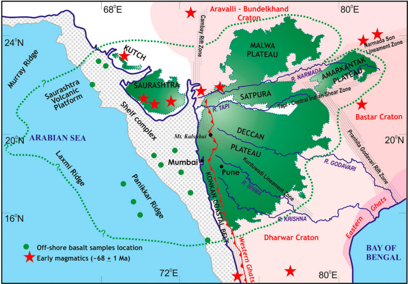
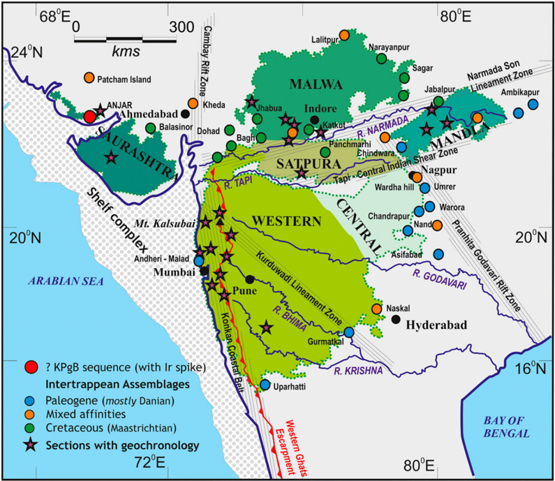
- Compiled >80 composite stratigraphic logs with ground validation at >500 locations across the DVP (excluding Saurashtra), using administrative districts as geographic reference and integrating GSI and published local data; districts were assigned to five subprovinces (Western, Satpura, Malwa, Mandla, Central).
- Volume computation used district-wise maximum thickness from elevation differences or geophysical/drilling estimates where basement was not exposed; Saurashtra was assigned 5% of the aggregate volume of other subprovinces, offshore basalts were estimated as three-fourths of on-land volume, and half the on-land volume was assumed to have survived erosional loss.
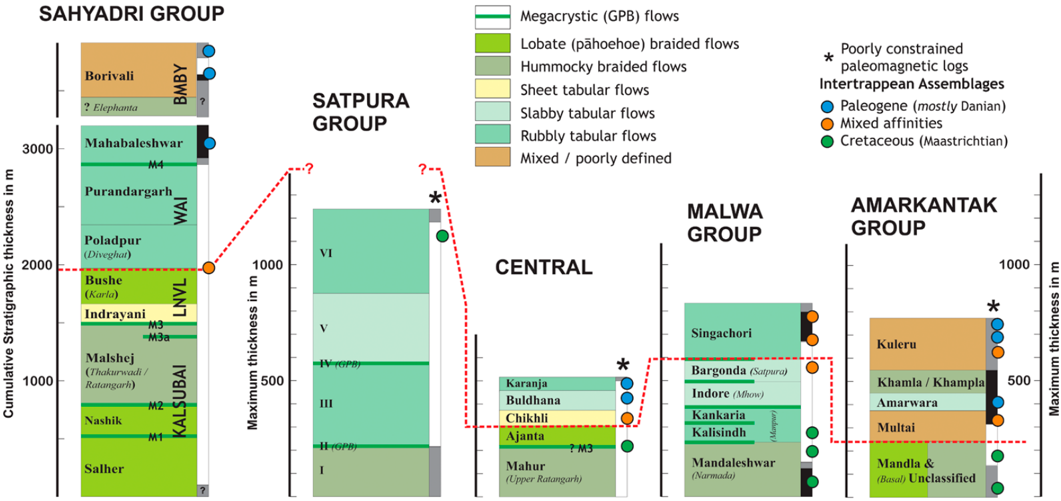
- Temporal distribution was divided into late Maastrichtian and Danian using geochronology, paleomagnetics, fossils from intertrappean sediments, and the inferred KPgB position; degassing estimates were recomputed from volumes using carbon and sulfur assumptions and compared with global temperature, warming events, and δ¹³C records.
Limitations
- Stated: Saurashtra was excluded from thickness computations due to structural complexity and uncertainties, and its volume was assigned notionally as 5% of the aggregate of other subprovinces divided equally between Maastrichtian and Danian.
- Stated: offshore basalts are recognized as potential sources of error; their OIB versus CFB designation is uncertain, thickness is inferred to vary from a few meters to 3900 m, and offshore volume is based on the ratio of aerial extent between on-land and offshore areas. The authors also assume half the on-land volume survived erosion while offshore basalts suffered little erosion.
- Stated: the Central subprovince lacks concrete geochronological data, so the KPgB is placed empirically at the top of the Ajanta Formation assuming Bushe–Ajanta equivalence; sulfur measurements are not available for other subprovinces, so conservative values were assigned. Evident: temporal assignments for several subprovinces rely on fossils, paleomagnetics, and correlations rather than direct dates, and no formal uncertainty ranges for the volume totals are reported.
Model-written summary. Check it against the paper before relying on it.
Integrity signals
Registry
Cites
Statistics
Figures
Verification
Claims the paper makes
25 Own interpretation · 19 No full text of the sources · 13 Own result · 11 Not checked yet · 10 Check pending · 6 Sources not found · 3 Own method
A result the paper reports from its own data — it cites no other source for it, so there is none to check. The quote shows it is in the paper.
In the paper
“Unlike earlier projections, we demonstrate that ∼70% of these lavas erupted in the terminal Maastrichtian before the KPgB.”
§ Spatio-temporal volume recalibration shows Deccan volcanism caused Terminal Cretaceous Mass Extinction > Abstract
boosted- Asserted: passes — The authors put it forward as true.
- Checkable: passes — It can be checked against evidence.
- Load-bearing: passes — The paper’s conclusions depend on it.
- Based: passes — The paper gives a reason why it holds.
A check of a cited source is scheduled, or we don’t hold its full text yet; the claim is checked once it runs.
In the paper
“Only the youngest Singarchori Formation of Malwa Group is of Danian age based on two dates (Tholt et al., 2023), namely, the intertrappean fossils and normal polarity (=Chron C29n) of the younger lavas recorded around Sagar (Madhya Pradesh, India; Singh et al., 2024).”
§ Spatio-temporal volume recalibration shows Deccan volcanism caused Terminal Cretaceous Mass Extinction > Malwa Subprovince
What the sources say
plain- Asserted: passes — The authors put it forward as true.
- Checkable: passes — It can be checked against evidence.
- Load-bearing: passes — The paper’s conclusions depend on it.
- Based: passes — The paper gives a reason why it holds.
In the paper
“Geochronological data from the rest of the sequence in the Malwa subprovince (Schöbel et al., 2014;Eddy et al., 2020;Patil Pillai et al., 2022) and the fossils from the intertrappean sediments as well as from the underlying Bagh Group and Lameta Formation”
§ Spatio-temporal volume recalibration shows Deccan volcanism caused Terminal Cretaceous Mass Extinction > Malwa Subprovince
What the sources say
boosted- Asserted: passes — The authors put it forward as true.
- Checkable: passes — It can be checked against evidence.
- Load-bearing: passes — The paper’s conclusions depend on it.
- Based: passes — The paper gives a reason why it holds.
In the paper
“The overlying sequence of Chikkli, Buldhana, and Karanja formations has morphological and petrological differences with the Wai Subgroup lava pile, notwithstanding the chemical correlations proposed by Bilgrami (1999).”
§ Spatio-temporal volume recalibration shows Deccan volcanism caused Terminal Cretaceous Mass Extinction > Central Subprovince
What the sources say
- Not matchedcites Bilgrami, 1999
Couldn’t be matched to a paper in Crossref, so it can’t be checked.
plain- Asserted: passes — The authors put it forward as true.
- Checkable: passes — It can be checked against evidence.
- Load-bearing: unclear — It is unclear whether the paper’s conclusions depend on it.
- Based: passes — The paper gives a reason why it holds.
- Not matched
A result the paper states — it cites no source for it, so there is none to check. The quote shows it is in the paper.
In the paper
“The time-averaged eruption rate for the post-KPgB lavas in Chron C29r is <300 km 3 /k.y. in comparison.”
§ Spatio-temporal volume recalibration shows Deccan volcanism caused Terminal Cretaceous Mass Extinction > DISCUSSION
plain- Asserted: passes — The authors put it forward as true.
- Checkable: passes — It can be checked against evidence.
- Load-bearing: passes — The paper’s conclusions depend on it.
- Based: passes — The paper gives a reason why it holds.
- It may state two separate claims as one. 22
- The quote only partly states this claim. 1
- Probably not a substantial claim. 15
Create a free account to see these claims.
Create a free account to see these assumptions.
48 more claims
Create a free account to see all 87 claims and to verify the 25 references still open.
Self-check
Percentages, sums and reported differences re-computed from the paper’s own numbers.
Each contradiction between two passages listed here was confirmed by an independent check.
Rated major: it would touch a result — a value a result rests on, reported and recomputed p-values on opposite sides of the significance level, two passages that conflict with no sign which is right, or a cited work retracted before this paper was published.
In the paper
§ Spatio-temporal volume recalibration shows Deccan volcanism caused Terminal Cretaceous Mass Extinction > Abstract
“Unlike earlier projections, we demonstrate that ∼70% of these lavas erupted in the terminal Maastrichtian before the KPgB.”
§ Spatio-temporal volume recalibration shows Deccan volcanism caused Terminal Cretaceous Mass Extinction > VOLUME
“The entire volume of the offshore basalts is assigned to the Danian age, based on their linkage and contemporaneity with the Bombay Subgroup.”
Rated minor: it would not touch a result — a value no result rests on, a p-value that stays on the same side of the significance level, or a conflict that is clerical, resolved elsewhere in the paper, or outside its own findings.
In the paper
“| Total volume (for 5 subprovinces) | 411.1 | 177.2 | 588.3 | | Saurashtra (@ 5% of above distributed evenly) | 14.7 | 14.7 | 29.4 | | Total on-land (% of volume) | 439.0 | 193.6 | 617.7 |”
§ Spatio-temporal volume recalibration shows Deccan volcanism caused Terminal Cretaceous Mass Extinction > CONCLUSIONS
Reported 439 · recomputed 425.8
Rated minor: it would not touch a result — a value no result rests on, a p-value that stays on the same side of the significance level, or a conflict that is clerical, resolved elsewhere in the paper, or outside its own findings.
In the paper
§ Spatio-temporal volume recalibration shows Deccan volcanism caused Terminal Cretaceous Mass Extinction > VOLUME
“As discussed in the section "Data and Assumptions," we estimate the offshore basalts to be 75% of the on-land volume.”
§ Spatio-temporal volume recalibration shows Deccan volcanism caused Terminal Cretaceous Mass Extinction > CONCLUSIONS
“| Total on-land (% of volume) | 439.0 | 193.6 | 617.7 | | | (69%) | (31%) | | | Total DVP present-day (including offshore estimates) | | | 1,107.2 |”
Rated minor: it would not touch a result — a value no result rests on, a p-value that stays on the same side of the significance level, or a conflict that is clerical, resolved elsewhere in the paper, or outside its own findings.
In the paper
“| Total on-land (% of volume) | 439.0 | 193.6 | 617.7 |”
§ Spatio-temporal volume recalibration shows Deccan volcanism caused Terminal Cretaceous Mass Extinction > CONCLUSIONS
Reported 617.7 · recomputed 632.6
Rated minor: it would not touch a result — a value no result rests on, a p-value that stays on the same side of the significance level, or a conflict that is clerical, resolved elsewhere in the paper, or outside its own findings.
In the paper
§ Spatio-temporal volume recalibration shows Deccan volcanism caused Terminal Cretaceous Mass Extinction > DISCUSSION
“∼70% of the preserved on-land 1.2 × 10 6 km 3”
§ Spatio-temporal volume recalibration shows Deccan volcanism caused Terminal Cretaceous Mass Extinction > CONCLUSIONS
“| Total on-land (% of volume) | 439.0 | 193.6 | 617.7 |”
Citations
Cites
U-Pb constraints on pulsed eruption of the Deccan Traps across the end-Cretaceous mass extinction
Schoene, B., Eddy, M. P., Samperton, K. M., Keller, C. B., Keller, G., Adatte, T., & Khadri, S. F. R. (2019) · Science · doi:10.1126/science.aau2422 · Cited by 542
U-Pb geochronology of the Deccan Traps and relation to the end-Cretaceous mass extinction
Schoene, B., Samperton, K. M., Eddy, M. P., Keller, G., Adatte, T., Bowring, S. A., Khadri, S. F. R., & Gertsch, B. (2015) · Science · doi:10.1126/science.aaa0118 · Cited by 443
State shift in Deccan volcanism at the Cretaceous-Paleogene boundary, possibly induced by impact
Renne, P. R., Sprain, C. J., Richards, M. A., Self, S., Vanderkluysen, L., & Pande, K. (2015) · Science · doi:10.1126/science.aac7549 · Cited by 431
The eruptive tempo of Deccan volcanism in relation to the Cretaceous-Paleogene boundary
Sprain, C. J., Renne, P. R., Vanderkluysen, L., Pande, K., Self, S., & Mittal, T. (2019) · Science · doi:10.1126/science.aav1446 · Cited by 395
Geomagnetic Polarity Time Scale
Ogg, J. G. (2020) · Geologic Time Scale 2020 · doi:10.1016/b978-0-12-824360-2.00005-x · Cited by 329
On impact and volcanism across the Cretaceous-Paleogene boundary
Hull, P. M., Bornemann, A., Penman, D. E., Henehan, M. J., Norris, R. D., Wilson, P. A., Blum, P., Alegret, L., Batenburg, S. J., Bown, P. R., et al. (2020) · Science · doi:10.1126/science.aay5055 · Cited by 279
Asteroid impact, not volcanism, caused the end-Cretaceous dinosaur extinction
Chiarenza, A. A., Farnsworth, A., Mannion, P. D., Lunt, D. J., Valdes, P. J., Morgan, J. V., & Allison, P. A. (2020) · Proceedings of the National Academy of Sciences · doi:10.1073/pnas.2006087117 · Cited by 228
Chenet, A., Courtillot, V., Fluteau, F., Gérard, M., Quidelleur, X., Khadri, S. F. R., Subbarao, K. V., & Thordarson, T. (2009) · Journal of Geophysical Research: Solid Earth · doi:10.1029/2008jb005644 · Cited by 221
JAY, A. E., & WIDDOWSON, M. (2008) · Journal of the Geological Society · doi:10.1144/0016-76492006-062 · Cited by 211
Triggering of the largest Deccan eruptions by the Chicxulub impact
Richards, M. A., Alvarez, W., Self, S., Karlstrom, L., Renne, P. R., Manga, M., Sprain, C. J., Smit, J., Vanderkluysen, L., & Gibson, S. A. (2015) · Geological Society of America Bulletin · doi:10.1130/b31167.1 · Cited by 210
Research works printed but not linked: 8
- Bhandari, 1996, K/T boundary layer in Deccan intertrappeans at Anjar, Kutch, 417
- Bilgrami, 1999, A reconnaissance geological map of the eastern part of the Deccan Traps (Bidar–Nagpur), 219
- Geological Survey of India (GSI), 2001, District Resources Map Series
- Kumari, 2020, Palaeosols and palaeoclimate reconstruction of the Maastrichtian Lameta Formation, Central India
- Nair, 2001, Stratigraphy of Deccan traps: A review, 477
- Nava, 2021, Reconciling early Deccan Traps CO2 outgassing and pre-KPB global climate, Proceedings of the National Academy of Sciences of the United States of America, 118
- Pande, 1988, 40Ar/39Ar ages of alkali basalts from Kutch, Deccan Volcanic Province, India, 145
- Prasad, 2021, Cretaceous mammals of India: Stratigraphic distribution, diversity and intercontinental affinities, Journal Paleosciences, 70, 173
Cited by
James, S., Chandran, S. R., Aswathi, J., Bhadran, A., Girishbai, D., Praveen, M. N., Chavan, A., Bhandari, S., Satyanarayanan, M., Mohan, R., et al. (2025) · Meteoritics and Planetary Science · doi:10.1111/maps.70081
Price, G. D., Jerrett, R., O’Connor, L. K., Crampton-Flood, E. D., van Dongen, B. E., Lengger, S. K., & Davies, M. (2026) · Paleoceanography and Paleoclimatology · doi:10.1029/2025pa005349
Columnar war bonnets in volcanic rocks, and their origin and significance
Sheth, H. C., Naik, A., Rai, A. K., Sheikh, J. M., & Kale, V. S. (2026) · Bulletin of Volcanology · doi:10.1007/s00445-026-02057-6
Self-citation
Metadata
- Authors
- Kale, V. S., Upasani, D., Rajput, M., Dole, G., & Pillai, S. P.
- Affiliations
- Advanced Center for Water Resources Development and Management (IN)
- Fergusson College (IN)
- Savitribai Phule Pune University (IN)
- Indian Institute of Science Education and Research Pune (IN)
- Corresponding author
- Pillai, Shilpa Patil
- Venue
- Geological Society of America Bulletin
- Publisher
- Geological Society of America
- Published
- 2025-11-05
- Volume
- 138
- Issue
- 3-4
- Pages
- 1749-1758
- ISSN
- 0016-7606 (ISSN-L)
- 1943-2674
- OpenAlex
- W4415930688
- Cited by
- 3
- References
- 74
- Citations by year
- 2026: 2 · 2025: 1
- FWCI
- 1.52
- Type
- journal article
- Language
- en
- Open access
- hybrid
- doi.org
- Licence
- cc-by
- Locations
- Geological Society of America Bulletin (publishedVersion, cc-by)
- Funders
- Indian Institute of Science
- Department of Science and Technology, Ministry of Science and Technology, India
- Indian Institute of Science Education and Research Pune
- Indian Institute of Science Education and Research Mohali
- Topics
- Physical Sciences › Earth and Planetary Sciences › Paleontology › Paleontology and Stratigraphy of Fossils
- Physical Sciences › Earth and Planetary Sciences › Geochemistry and Petrology › Geological and Geochemical Analysis
- Physical Sciences › Earth and Planetary Sciences › Geology › Geological and Geophysical Studies
- Keywords
- Deccan flood basalts, Cretaceous-Paleogene boundary, degassing, biotic recovery, Danian
About these checks
Registry, retraction, Cites and statistics results are computed, not judged, with one exception: a printed reference that no index lists is read once by a model before it counts as a citation error. Claims are extracted by a model and kept only when their quote appears verbatim in the text; each cited source is then checked, with a model’s help, for whether it says what the claim relies on. Those verdicts can be wrong — read the claim’s quote and the cited source before relying on one.
A language model drew the claims from the paper on 2026-11-12, under version 3 of the claim definition (model deepseek-v4.1-flash, prompt extract-v3).
A second model labelled each claim on 2026-11-12 (model jev-1.13-20260917, definition revision gold-guideline-v0.2).
Statistics and arithmetic are recomputed, not judged.
Confidence bands are shown only for fields calibrated on our annotated test set. None is calibrated yet, so no band is shown.
What counts as a claim ›How we measure confidence ›How we check this ›
Are you an author, or do you see a problem with this page? Request a review
How to cite
Cite CoChat for the checks on this page, and the paper for its own findings.
- This page
- CoChat. (2026). Citation check: Spatio-temporal volume recalibration shows Deccan volcanism caused Terminal Cretaceous Mass Extinction. https://app.cochat.ai/papers/10.1130/b38412.1
- The paper
- Kale, V. S., Upasani, D., Rajput, M., Dole, G., & Pillai, S. P. (2026). Spatio-temporal volume recalibration shows Deccan volcanism caused Terminal Cretaceous Mass Extinction. Geological Society of America Bulletin. https://doi.org/10.1130/b38412.1
