

The DOI matches its Crossref record; 36 of the 36 references it cites were found in a registry or an index.
Mapping landscape in Longshan period’s hierarchical society (3000–2000BCE) of North Loess Plateau: from archaeological predictive model to GIS spatial analysis
Abstract
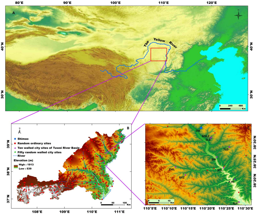
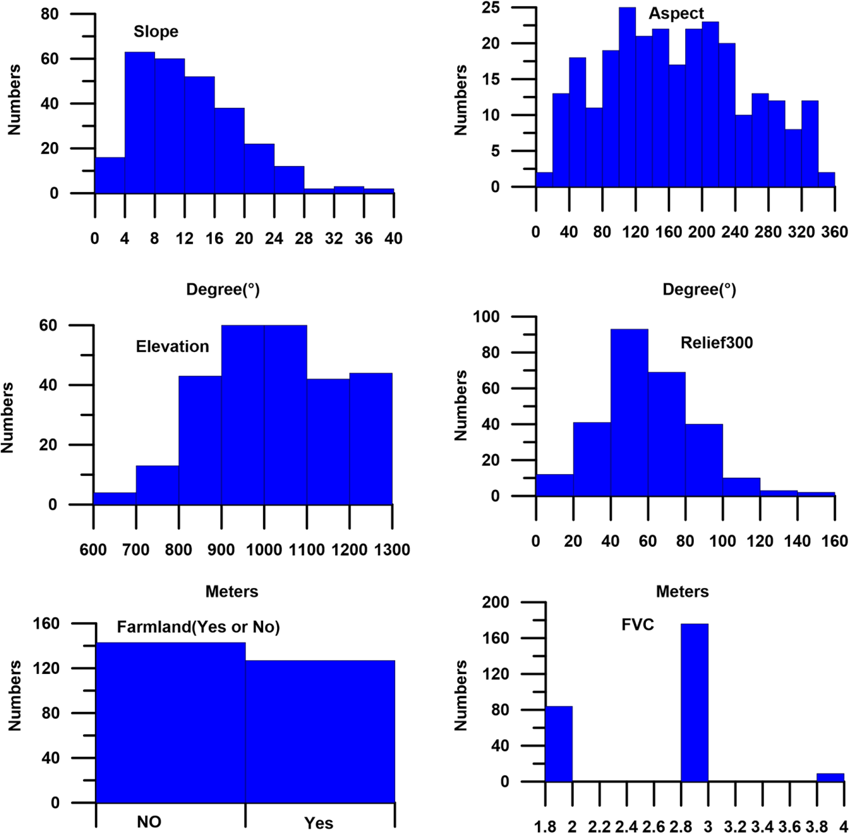
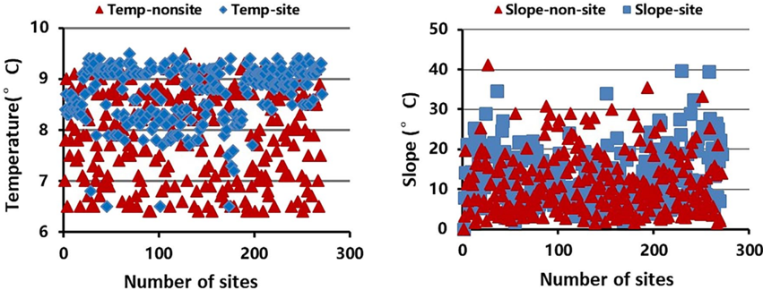
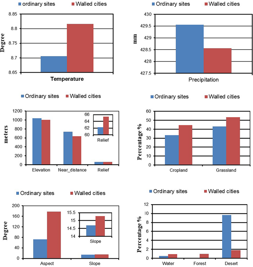
On the North Loess Plateau of China, city civilization, social complexity, and stratification emerged during the Longshan period (3000-2000BCE). Based on Geographic Information System (GIS) analysis and archaeological predictive model, we conducted a comparative analysis of environmental characteristics between sites and non-sites, ordinary and walled city sites, as well as large and smaller city sites. Initially, we developed a Binary Logistic Regression (BLR) model to predict the locations of archaeological sites from this period. Our findings indicate a high predictive accuracy of the model, demonstrating a clear environmental preference by the people of the Longshan Period. The presence or absence of the site was found to be influenced by various factors, including temperature, elevation, river distance, and precipitation. Furthermore, we discovered that walled cities had higher environmental requirements compared to ordinary sites. Terrain and land use played a more significant role in shaping prehistoric cities than climate. Lastly, the landscape in the Shimao site, which served as a most crucial and largest settlement centers on the North Loess Plateau (NLP), resembled that of other minor walled cities. Due to its abundant grassland, Shimao relied more on animal husbandry rather than agriculture. The combination of agriculture and animal husbandry has promoted the urbanization processes.
Overview
The claims and statistics of this paper haven’t been checked yet.
Run the check — free, no account needed. It reads the open-access text and checks the sources it cites.
Integrity signals
Registry
Cites
Statistics
Figures
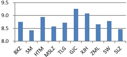
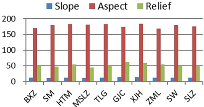
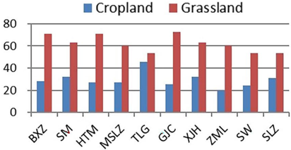
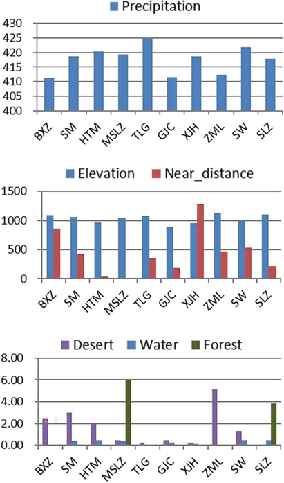
Verification
Claims the paper makes
The claims and statistics of this paper haven’t been checked yet.
Run the check — free, no account needed. It reads the open-access text and checks the sources it cites.
Claims other papers make about this one
Each is checked against this paper’s own text: does it say what the citing paper says it does?
The cited source says what the claim attributes to it.
In the citing paper
“Studies have demonstrated a marked preference for certain altitude ranges which offer more favorable environmental conditions (Abou Diwan, 2020;Cui, 2024;Duffy et al., 2023).”
From Predictive modeling for targeted archaeological survey of arsacid period sites in the iranian borderland region of the araxes river valley (2026) · cites this paper as Cui, 2024
The cited source says what the claim attributes to it.
In the citing paper
“Proximity to water is a critical aspect that greatly determines settlement patterns (Cui, 2024;Duffy et al., 2023;Yaworsky et al., 2020).”
From Predictive modeling for targeted archaeological survey of arsacid period sites in the iranian borderland region of the araxes river valley (2026) · cites this paper as Cui, 2024
In the citing paper
“Slope is defined as ground steepness, a common variable in archaeological predictive models (Cui, 2024;Duffy et al., 2023).It is closely related to cultivation potential as flat locations are preferred for agricultural activities due to the lower costs of labor and resources required for land modification.”
From Predictive modeling for targeted archaeological survey of arsacid period sites in the iranian borderland region of the araxes river valley (2026) · cites this paper as Cui, 2024
Self-check
Percentages, sums and reported differences re-computed from the paper’s own numbers.
The self-check needs the paper’s full text.
Citations
Cites
Crop manuring and intensive land management by Europe’s first farmers
Bogaard, A., Fraser, R., Heaton, T. H. E., Wallace, M. P., Vaiglova, P., Charles, M., Jones, G., Evershed, R. P., Styring, A., Andersen, N. H., et al. (2013) · Proceedings of the National Academy of Sciences · doi:10.1073/pnas.1305918110 · Cited by 698
Li, L., & Chen, X. (2012) · Cambridge University Press eBooks · doi:10.1017/cbo9781139015301 · Cited by 480
Isotope evidence for agricultural extensification reveals how the world's first cities were fed
Styring, A., Charles, M., Fantone, F., Hald, M. M., McMahon, A., Meadow, R. H., Nicholls, G. K., Patel, A. K., Pitre, M. C., Smith, A., et al. (2017) · Nature Plants · doi:10.1038/nplants.2017.76 · Cited by 232
Initial Social Complexity in Southwestern Asia
Algaze, G. (2001) · Current Anthropology · doi:10.1086/320005 · Cited by 173
Yaworsky, P. M., Vernon, K. B., Spangler, J. D., Brewer, S. C., & Codding, B. F. (2020) · PLOS One · doi:10.1371/journal.pone.0239424 · Cited by 104
The first Neolithic urban center on China's north Loess Plateau: The rise and fall of Shimao
Sun, Z., Shao, J., Li, L., Cui, J., Bonomo, M. F., Guo, Q., Wu, X., & Wang, J. (2017) · Archaeological Research in Asia · doi:10.1016/j.ara.2017.02.004 · Cited by 88
Self-citationA predictive model of archaeological potential: An example from northwestern Belize
Vaughn, S., & Crawford, T. (2009) · Applied Geography · doi:10.1016/j.apgeog.2009.01.001 · Cited by 66
Cheung, C., Zhang, H., Hepburn, J. C., Yang, D. Y., & Richards, M. P. (2019) · PLoS ONE · doi:10.1371/journal.pone.0218943 · Cited by 56
A supervised machine-learning approach towards geochemical predictive modelling in archaeology
Oonk, S., & Spijker, J. (2015) · Journal of Archaeological Science · doi:10.1016/j.jas.2015.04.002 · Cited by 53
Jasiewicz, J., & Hildebrandt‐Radke, I. (2009) · Journal of Archaeological Science · doi:10.1016/j.jas.2009.06.004 · Cited by 53
Research works printed but not linked: 21
- DemattÈ P. Longshan-Era urbanism: the role of cities in predynastic China. Asian Perspect. 1999;38:119–53.
- Wang W, Guo X. Research on the settlement pattern and society during Longshan and Xia periods. Archaeol Cult Relics. 2016;216:52–9.
- Hu K, Mo D, Mao L, Li S, Wang H. Spatial analysis and landscape significance of mankind settlement sites in Wuding River Basin in Mid-Holocene. Scientia Geographica Sinica. 2011;31:415–20.
- Christianne LF, Konstantinos PT. Detecting variability: a study on the application of bayesian multilevel modelling to archaeological data. Evidence from the Neolithic Adriatic and the Bronze Age Aegean. J Archaeol Sci. 2021;128:1–14.
- Sharafi S, Fouladvand S, Simpson I, Alvarez JAB. Application of pattern recognition in detection of buried archaeological sites based on analysing environmental variables, Khorramabad Plain. West Iran J Archaeol Sci-Rep. 2016;8:206–15.
- Canilao MAP. Weight of evidence predictive modelling and potential locations of ancient gold mining settlements in Benguet in the 16th to 18th centuries. Philipp J Sci. 2017;146:187–92.
- Sun Z, Shao J, Shao A, Kuang N, Qu F, Liu X. Shimao site of Shenmu county, Shaanxi Province. Archaeology. 2013;1248:15–24.
- Lü Z. Shimao ancient city: early human civilization development and environment choices. J Hist Geogr. 2016;31(63–8):139.
- Jaang L, Sun Z, Shao J, Li M. When peripheries were centres: a preliminary study of the Shimao-centred polity in the loess highland. China Antiq. 2018;92:1008–22.
- Chen W. The erosional rates of the loess region in the Wudinghe Riv-er catchment. Arid Land Geography. 1989;12:25–30.
- Garavaglia SB, Dun AS, Hill BM. A smart guide to dummy variables: four applications and a macro. Paper presented at the Proceedings of the Northeast SAS Users Group Conference.1998; Pittsburgh, PA, USA.
- Hu S, Zhang P, Yuan M. A study on the faunal remains from the Huoshiliang site in Yulin. Shaanxi Province Acta Anthropologica Sinica. 2008;27:232–48.
- Hu S, Yang T, Yang M, Shao J, Di N. Research on faunal remains from the miaoliang site in jingbian county, Northern Shaanxi on the formation of animal husbandry in china. Quat Sci. 2022;42:17–31.
- Feng X. Settlement, subsistence strategies and environment background of Hetao region from Yangshao to Longshan periods. Master thesis. 2019.
- Hu S, Yang M, Sun Z, Shao J. Research on faunal remains excavated from 2012 to 2013 of Shimao Site, Shenmu county. Shaanxi province Archaeology and Cultural Relics. 2016;216:109–21.
- Yang M, Hu S, Guo X, Wang W, Yang T. Research on the faunal remain-s from Muzhuzhuliang Site in Shenmu city Shaanxi. Acta Anthropologica Sin-ica. 2017;41:394–404.
- Tian G, Tang X. A study on the man-environment relation in the Daihai area of inner-Mongolia. Collect Essays Chin Hist Geogr. 2001;16:4.
- Han J. Expansion and influence of Laohushan culture. Cult Relics Cent China. 2007;133:20.
- Lu Z, Hui R, Lü W, Sun Z, Shao J, Di N, Liu J. Observation and research on textile unearthed from the Shimao Site in Shenmu county, Shaanxi Province. Archaeology. 2023;1441:106–20.
- Kempf M, Günther G. Point pattern and spatial analyses using archaeological and environmental data—a case study from the Neolithic Carpathian Basin. J Archaeol Sci Rep. 2023;47: 103747.
- Verhagen JWHP. Chapter 2- spatial analysis in archaeology: moving into new territories. In: Bubenzer O, Siart C, Forbriger M, editors. Digital geoarchaeology: new techniques for interdisciplinary human-environmental research. Cham: Springer; 2017. p. 11–25.
Cited by
Wang, J., Soroush, M., Maziar, S., & Khazraee, E. (2026) · Journal of Archaeological Method and Theory · doi:10.1007/s10816-025-09733-5 · Cited by 3
Metadata
- Authors
- Cui, J.
- Venue
- Heritage Science
- Published
- 2024-03-05
- Volume
- 12
- Issue
- 1
- ISSN
- 2050-7445
- Cited by
- 15
- References
- 36
- Language
- en
- Licence
- creativecommons.org/licenses/by/4.0 (tdm)
- creativecommons.org/licenses/by/4.0 (vor)
- Funders
- Ministry of Education, China (22JJD70053)
- National Natural Science Foundation of China (41571190)
About these checks
Registry, retraction, Cites and statistics results are computed, not judged, with one exception: a printed reference that no index lists is read once by a model before it counts as a citation error. Claims are extracted by a model and kept only when their quote appears verbatim in the text; each cited source is then checked, with a model’s help, for whether it says what the claim relies on. Those verdicts can be wrong — read the claim’s quote and the cited source before relying on one.
Statistics and arithmetic are recomputed, not judged.
Confidence bands are shown only for fields calibrated on our annotated test set. None is calibrated yet, so no band is shown.
What counts as a claim ›How we measure confidence ›How we check this ›
Are you an author, or do you see a problem with this page? Request a review
How to cite
Cite CoChat for the checks on this page, and the paper for its own findings.
- This page
- CoChat. (2026). Citation check: Mapping landscape in Longshan period’s hierarchical society (3000–2000BCE) of North Loess Plateau: from archaeological predictive model to GIS spatial analysis. https://app.cochat.ai/papers/10.1186/s40494-024-01194-5
- The paper
- Cui, J. (2024). Mapping landscape in Longshan period’s hierarchical society (3000–2000BCE) of North Loess Plateau: from archaeological predictive model to GIS spatial analysis. Heritage Science. https://doi.org/10.1186/s40494-024-01194-5
Data sources
Bibliographic data: Semantic Scholar, OpenAlex, Crossref.
Contains information from the Semantic Scholar Academic Graph Datasets, made available under the ODC Attribution License (ODC-BY 1.0).
Semantic Scholar’s data is described in: Kinney, R., et al. (2023). The Semantic Scholar Open Data Platform. arXiv:2301.10140.
