

The DOI matches its Crossref record; 38 of the 38 references it cites were found in a registry or an index.
A Geological and Spatial Approach to Prehistoric Archaeological Surveys on Small Islands: Case Studies from Maluku Barat Daya, Indonesia
Abstract
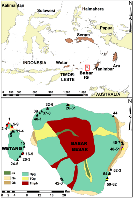
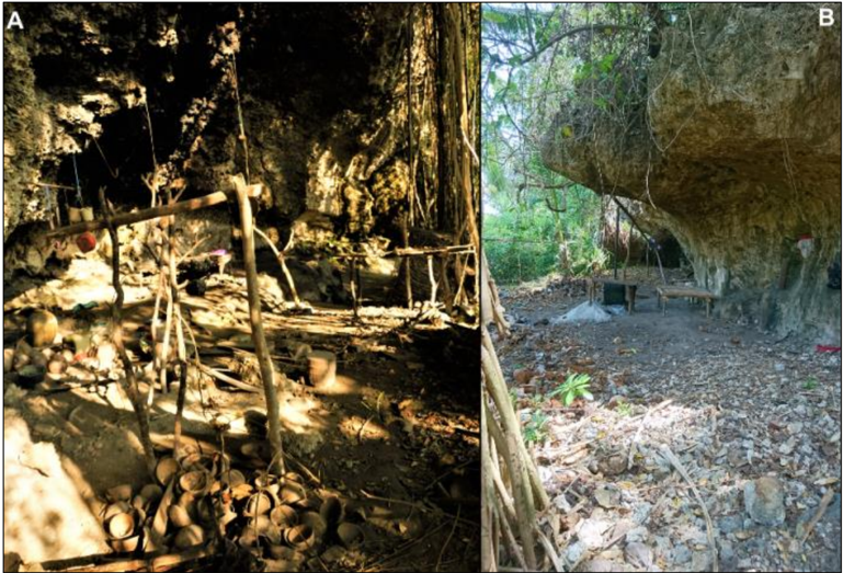
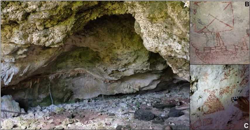
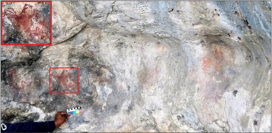
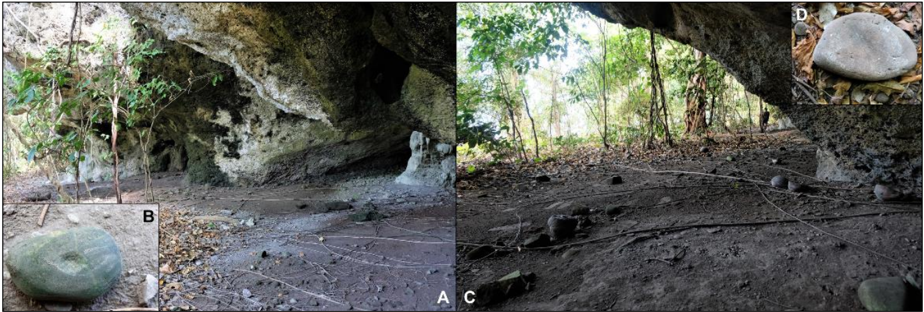
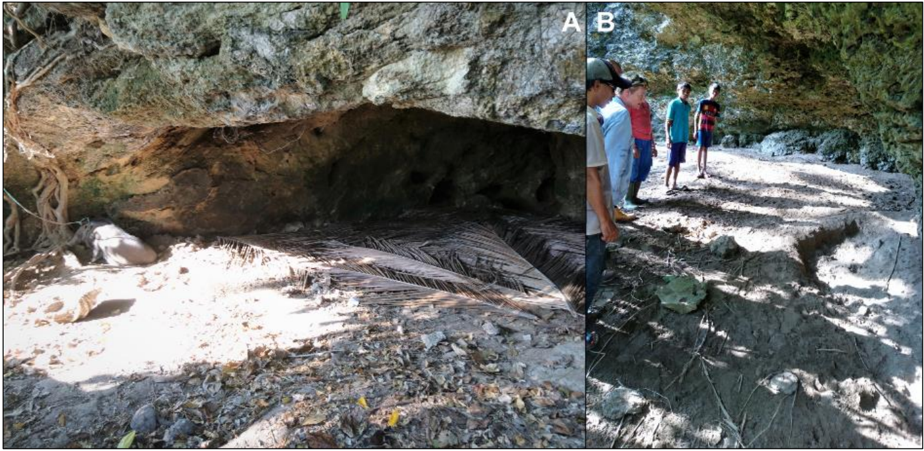
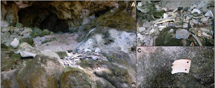
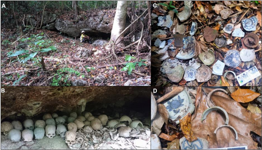
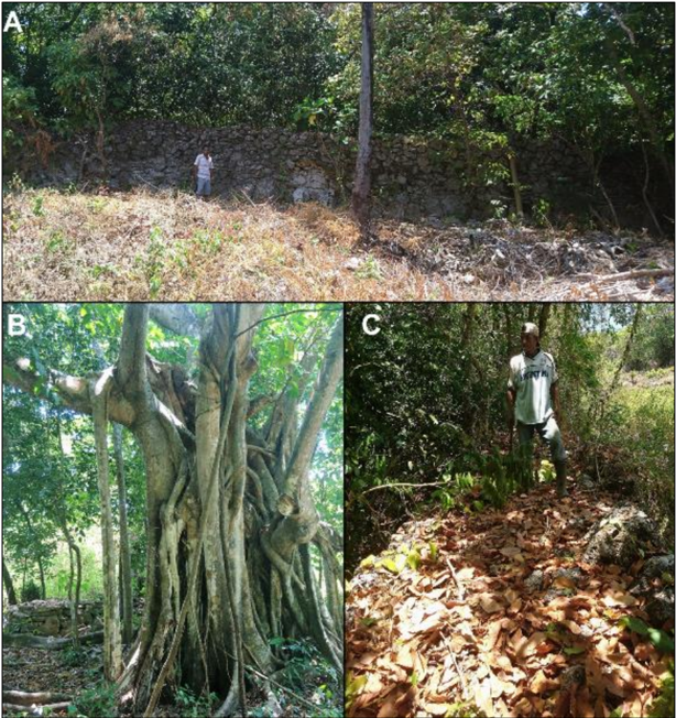
Survei arkeologi sangat penting untuk penemuan dan interpretasi sisa-sisa yang ditinggalkan oleh aktivitas manusia prasejarah. Saat ini penginderaan jarak jauh dan model prediktif telah meningkatkan jangkauan dan keberhasilan survei arkeologi, namun survei pejalan kaki untuk mengembangkan parameter model dan prediksi kebenaran dasar masih penting untuk keberhasilan suatu penemuan. Penelitian ini merupakan hasil survei arkeologi tahun 2017 di Pulau Babar Besar dan Pulau Wetang yang termasuk dalam bagian dari kelompok Kepulauan Babar, Maluku Barat Daya, Indonesia. Tercatat sebanyak 62 situs arkeologi ditemukan di kedua pulau tersebut, tujuh diantaranya merupakan situs lukisan cadas baru yang ditemukan di Pulau Wetang. Hasil survei ini menunjukkan keberhasilan penggunaan peta geologi dan topografi di samping citra satelit dalam mendeteksi daerah prospektif untuk survei. Hasil penelitian ini juga menunjukkan bahwa pemahaman karakteristik geologi daerah yang lebih rinci dan komparatif diperlukan sebelum dilakukan survei jarak jauh yang lebih lanjut di wilayah Maluku Barat Daya, Indonesia.Archaeological surveys are essential to the discovery and interpretation of remains left by past human activities. While remote sensing and predictive models have greatly improved the reach and success of archaeological survey, pedestrian surveys to develop model parameters and ground-truth predictions is still imperative for successful discoveries. Here we present the results of the 2017 archaeological survey of islands Babar Besar and Wetang in the Babar Island Group, Maluku Barat Daya, Indonesia. A total of 62 archaeological sites were recorded between the two islands; seven of which represent new rock art sites on Wetang island. Our survey results indicate the successful use of geological and topographic maps alongside satellite images in detecting prospective regions for survey. Results also indicate however that a more detailed and comparative understanding of the regions geology is required before more advanced forms of remote survey are conducted in the Maluku Barat Daya region.
Overview
The claims and statistics of this paper haven’t been checked yet.
Run the check — free, no account needed. It reads the open-access text and checks the sources it cites.
Integrity signals
Registry
Cites
Statistics
Figures
Verification
Claims the paper makes
The claims and statistics of this paper haven’t been checked yet.
Run the check — free, no account needed. It reads the open-access text and checks the sources it cites.
Claims other papers make about this one
Each is checked against this paper’s own text: does it say what the citing paper says it does?
In the citing paper
“however, excavations and radiocarbon dates are limited, with the earliest calibrated dates for occupation of this island group no older than 7 ka (Latinis and Stark, 2005;Kealy et al., 2018).”
From Least-cost pathway models indicate northern human dispersal from Sunda to Sahul (2018) · cites this paper as Kealy et al., 2018
Self-check
Percentages, sums and reported differences re-computed from the paper’s own numbers.
The self-check needs the paper’s full text.
Citations
Cites
Bayesian Analysis of Radiocarbon Dates
Bronk Ramsey, C. (2009) · Radiocarbon · doi:10.1017/s0033822200033865 · Cited by 8,725
Australopithecus sediba : A New Species of Homo -Like Australopith from South Africa
Berger, L. R., de Ruiter, D. J., Churchill, S. E., Schmid, P., Carlson, K. J., Dirks, P. H. G. M., & Kibii, J. M. (2010) · Science · doi:10.1126/science.1184944 · Cited by 613
Uncovering archaeological landscapes at Angkor using lidar
Evans, D. H., Fletcher, R. J., Pottier, C., Chevance, J.-B., Soutif, D., Tan, B. S., Im, S., Ea, D., Tin, T., Kim, S., et al. (2013) · Proceedings of the National Academy of Sciences · doi:10.1073/pnas.1306539110 · Cited by 352
GIS and Archaeological Site Location Modeling
(2005) · CRC Press eBooks · doi:10.1201/9780203563359 · Cited by 144
Alexakis, D. D., Sarris, A., Αστάρας, Θ., & Albanakis, K. (2010) · Journal of Archaeological Science · doi:10.1016/j.jas.2010.08.013 · Cited by 94
Kealy, S., Louys, J., & O'Connor, S. (2017) · Archaeological Prospection · doi:10.1002/arp.1570 · Cited by 89
Self-citationKisar and the Archaeology of Small Islands in the Wallacean Archipelago
O’Connor, S., Mahirta, M., Kealy, S., Boulanger, C., Maloney, T., Hawkins, S., Langley, M. C., Kaharudin, H. A. F., Suniarti, Y., Husni, M., et al. (2018) · The Journal of Island and Coastal Archaeology · doi:10.1080/15564894.2018.1443171 · Cited by 76
Self-citationPolitical dynamics and religious change in the late pre-colonial Banda Islands, Eastern Indonesia
Lape, P. V. (2000) · World Archaeology · doi:10.1080/004382400409934 · Cited by 67
A predictive model of archaeological potential: An example from northwestern Belize
Vaughn, S., & Crawford, T. (2009) · Applied Geography · doi:10.1016/j.apgeog.2009.01.001 · Cited by 66
The Oxford Companion To Archaeology
Atakuman, Ç. (2012) · Oxford University Press eBooks · doi:10.1093/acref/9780199735785.001.0001 · Cited by 65
The Archaeology of the Aru Islands, Eastern Indonesia
O’Connor, S., Spriggs, M., & Veth, P. (2007) · ANU Press eBooks · doi:10.22459/ta22.2007 · Cited by 57
Self-citationA previously unreported bronze kettledrum from the Kai Islands, Eastern Indonesia
Spriggs, M., & Miller, D. (1988) · Bulletin of the Indo-Pacific Prehistory Association · doi:10.7152/bippa.v8i0.11269 · Cited by 52
Fortification as a human response to late Holocene climate change in East Timor
Lape, P. V., & CHIN‐YUNG, C. (2008) · Archaeology in Oceania/Archæology & physical anthropology in Oceania · doi:10.1002/j.1834-4453.2008.tb00026.x · Cited by 42
The archaeology of the Aru Islands, Eastern Indonesia
Rosendahl, D. (2006) · Australian Archaeology · Cited by 38
O’Connor, S., Mahirta, M., Tanudirjo, D. A., Ririmasse, M. N. R., Husni, M., Kealy, S., Hawkins, S., & Alifah, A. (2017) · Cambridge Archaeological Journal · doi:10.1017/s0959774317000816 · Cited by 37
Self-citationChronology of Fortified Settlements in East Timor
Lape, P. V. (2006) · The Journal of Island and Coastal Archaeology · doi:10.1080/15564890600939409 · Cited by 34
Dudumahan: a rock art site on Kai Kecil, S.E. Moluccas
Ballard, C. (1988) · Bulletin of the Indo-Pacific Prehistory Association · doi:10.7152/bippa.v8i0.11274 · Cited by 34
Meredith‐Williams, M., Hausmann, N., Bailey, G. N., et al. (2014) · World Archaeology · doi:10.1080/00438243.2014.890913 · Cited by 23
Lape, P. V. (2002) · Asian perspectives · doi:10.1353/asi.2002.0005 · Cited by 23
Parcak, S. H., Mumford, G. D., & Childs, C. (2017) · Geosciences · doi:10.3390/geosciences7040094 · Cited by 23
Austronesian Diaspora a new perspective
Bellwood, P. S., Hantoro, W. S., & Lape, P. V. (2016) · Pusat Penelitian Arkeologi Nasional eBooks · Cited by 23
THE RESPONSE OF EARLY AMBONESE FORAGERS TO THE MALUKU SPICE TRADE: THE ARCHAEOLOGICAL EVIDENCE
Stark, K. D. (1996) · ScholarSpace (University of Hawaii at Manoa) · Cited by 17
The Archaeological Survey Manual
White, G. G., & King, T. F. (2016) · Routledge eBooks · doi:10.4324/9781315419138 · Cited by 16
Preliminary Observation of a New Cranium of Homo erectus (Tjg-1993.05) from Sangiran, Central Jawa.
Arif, J., Kaifu, Y., Baba, H., Suparka, M. E., Zaim, Y., & Setoguchi, T. (2002) · Anthropological Science · doi:10.1537/ase.110.165 · Cited by 16
Locating Macedonian tombs using predictive modelling
Balla, A., Pavlogeorgatos, G., Tsiafaki, D., & Pavlidis, G. P. (2012) · Journal of Cultural Heritage · doi:10.1016/j.culher.2012.10.011 · Cited by 15
A New Hominid Skull Cap from Pleistocene Sangiran
Jacob, T. (1964) · Anthropologica · doi:10.2307/25604601 · Cited by 15
Airborne LiDAR prospection at Lovea, an Iron Age moated settlement in central Cambodia
O’Reilly, D. J. W., Evans, D. H., & Shewan, L. G. (2017) · Antiquity · doi:10.15184/aqy.2017.69 · Cited by 15
Cave use variability in central Maluku, eastern Indonesia
Latinis, D. K., & Stark, K. (2005) · Asian Perspectives · doi:10.1353/asi.2005.0009 · Cited by 14
Ellen, R. F., & Glover, I. C. (1974) · Man · doi:10.2307/2800690 · Cited by 14
A newHomo erectus cranium from Sangiran, Java
Tyler, D. E., & Sartono, S. (2001) · Human Evolution · doi:10.1007/bf02438919 · Cited by 10
Ririmasse, M. N. R. (2016) · Kapata Arkeologi · doi:10.24832/kapata.v12i1.318 · Cited by 8
Application of Geo-Informatics to the Study of the Royal Road from Angkor to Phimai
Lertlum, S., & Shibayama, M. (2009) · Japanese Journal of Southeast Asian Studies · doi:10.20495/tak.46.4_547 · Cited by 7
Ririmasse, M. N. R. (2016) · Kapata Arkeologi · doi:10.24832/kapata.v12i2.317 · Cited by 6
Arkeologi Pulau-pulau Terdepan di Maluku, Suatu Tinjauan Awal
Ririmasse, M. N. R. (2010) · Kapata Arkeologi · doi:10.24832/kapata.v6i10.132 · Cited by 6
Arkeologi Pulau Terluar Di Maluku: Survei Arkeologi Pulau Masela
Ririmasse, M. N. R. (2013) · KALPATARU · doi:10.24832/kpt.v22i2.125 · Cited by 4
Survey dan Pemodelan 3D (Tiga Dimensi) untuk Dokumentasi Digital Candi Borobudur
Suwardhi, D., Mukhlisin, M., Darmawan, D., Trisyanti, S. W., Brahmantara, B., & Suhartono, Y. (2016) · Jurnal Konservasi Cagar Budaya · doi:10.33374/jurnalkonservasicagarbudaya.v10i2.150 · Cited by 3
Jaime, Z. (2007) · Cited by 2
Satellite Imagery Uncovers Up to 17 Lost Egyptian Pyramids
(2021) · AAAS Articles DO Group · doi:10.1126/article.28769 · Cited by 2
Research works printed but not linked: 7
- Glover, I. C., & Ellen, R. F. (1975). Ethnographie and archaeological aspects of a flaked stone collection from Seram, Eastern Indonesia. Asian Perspectives, 18(1), 51- 60.
- Latinis, K. & Stark, K. (2003). Roasted dirt: Assessing earthenware assemblages from sites in Central Maluku, Indonesia. In J. N. Miksic (Ed.), Earthenware in Southeast Asia (pp. 103-135). Singapore: Singapore University Press.
- O'Connor, S., Aplin, K., Spriggs, M., Veth, P., & Ayliffe, L. A. (2002). From savannah to rainforest: changing environments and human occupation at Liang Lemdubu, the Aru Islands, Maluku, Indonesia. In A. P. Kershaw, B. David, N. Tapper, D. Penny, & J. Brown (Eds.), Bridging Wallace's Line: The Environmental and Cultural History and Dynamics of the Southeast Asian-Australian Region (pp. 279-306). Reiskirchen: Catena Verlag. Advances in GeoEcology 34.
- Orton, C. (2000). Sampling in Archaeology. Cambridge: Cambridge University Press.
- Röder, J. (1938). Felsbilder auf Ceram. Paideuma: Mitteilungen zur Kulturkunde. 1(1), 19-28.
- Spriggs, M. & Miller, D. (1979). Ambon-Lease: A study of contemporary pottery making and trade in Eastern Indonesia and its archaeological relevance. In M. Millett (Ed.), Pottery and the Archaeologist (pp. 25-34). London: Occasional Paper No. 4 of the Institute of Archaeology, London.
- Spriggs, M. (1990). Archaeological and ethnoarchaeological research in Maluku 1975 and 1977: an unfinished story. Cakalele: Maluku Research Journal, 1(1-2), 51-65.
Cited by
Least-cost pathway models indicate northern human dispersal from Sunda to Sahul
Kealy, S., Louys, J., & O'Connor, S. (2018) · Journal of Human Evolution · doi:10.1016/j.jhevol.2018.10.003 · Cited by 169
Self-citation
Metadata
- Authors
- Kealy, S., Wattimena, L., & O'Connor, S.
- ORCID
- Kealy, Shimona
- Venue
- Kapata Arkeologi
- Published
- 2018-07-30
- Volume
- 14
- Issue
- 1
- Pages
- 1
- ISSN
- 2503-0876
- 1858-4101
- Cited by
- 8
- References
- 38
About these checks
Registry, retraction, Cites and statistics results are computed, not judged, with one exception: a printed reference that no index lists is read once by a model before it counts as a citation error. Claims are extracted by a model and kept only when their quote appears verbatim in the text; each cited source is then checked, with a model’s help, for whether it says what the claim relies on. Those verdicts can be wrong — read the claim’s quote and the cited source before relying on one.
Statistics and arithmetic are recomputed, not judged.
Confidence bands are shown only for fields calibrated on our annotated test set. None is calibrated yet, so no band is shown.
What counts as a claim ›How we measure confidence ›How we check this ›
Are you an author, or do you see a problem with this page? Request a review
Data sources
Bibliographic data: Semantic Scholar, OpenAlex, Crossref.
Contains information from the Semantic Scholar Academic Graph Datasets, made available under the ODC Attribution License (ODC-BY 1.0).
Semantic Scholar’s data is described in: Kinney, R., et al. (2023). The Semantic Scholar Open Data Platform. arXiv:2301.10140.
