

Flood Susceptibility Mapping through the GIS-AHP Technique Using the Cloud
Open accessThe DOI matches its Crossref record; 55 of the 55 references it cites were found in a registry or an index.
Abstract
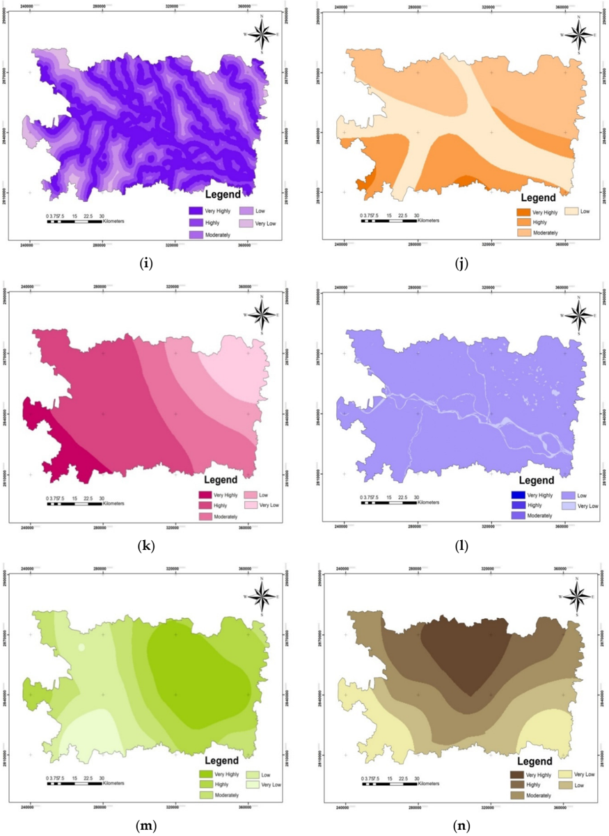
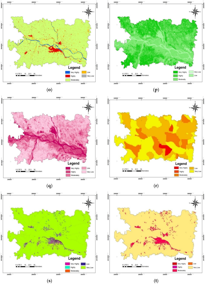
Flood susceptibility mapping is essential for characterizing flood risk zones and for planning mitigation approaches. Using a multi-criteria decision support system, this study investigated a flood susceptible region in Bihar, India. It used a combination of the analytical hierarchy process (AHP) and geographic information system (GIS)/remote sensing (RS) with a cloud computing API on the Google Earth Engine (GEE) platform. Five main flood-causing criteria were broadly selected, namely hydrologic, morphometric, permeability, land cover dynamics, and anthropogenic interference, which further had 21 sub-criteria. The relative importance of each criterion prioritized as per their contribution toward flood susceptibility and weightage was given by an AHP pair-wise comparison matrix (PCM). The most and least prominent flood-causing criteria were hydrologic (0.497) and anthropogenic interference (0.037), respectively. An area of ~3000 sq km (40.36%) was concentrated in high to very high flood susceptibility zones that were in the vicinity of rivers, whereas an area of ~1000 sq km (12%) had very low flood susceptibility. The GIS-AHP technique provided useful insights for flood zone mapping when a higher number of parameters were used in GEE. The majorities of detected flood susceptible areas were flooded during the 2019 floods and were mostly located within 500 m of the rivers’ paths.
Overview
The claims and statistics of this paper haven’t been checked yet.
Free: it reads the open-access text and checks the first 5 claims that cite a source we can check. Create a free account to check every claim.
Integrity signals
Registry
Cites
Statistics
Figures




Verification
Claims the paper makes
The claims and statistics of this paper haven’t been checked yet.
Free: it reads the open-access text and checks the first 5 claims that cite a source we can check. Create a free account to check every claim.
Claims other papers make about this one
Each is checked against this paper’s own text: does it say what the citing paper says it does?
The source backs part of the claim, not all of it — or backs it for a different population, condition or comparison.
In the citing paper
“Elevation significantly impacts flood vulnerability, with lower-lying areas typically facing a higher risk of flooding, especially in coastal regions [59,60].”
From Urban Flood Vulnerability Assessment in Freetown, Sierra Leone: AHP Approach (2024) · cites this paper as [59]
Experimental — accuracy not yet measured
Self-check
Percentages, sums and reported differences re-computed from the paper’s own numbers.
The self-check needs the paper’s full text.
Citations
Cites
Red and photographic infrared linear combinations for monitoring vegetation
Tucker, C. J. (1979) · Remote Sensing of Environment · doi:10.1016/0034-4257(79)90013-0 · Cited by 11,754 · cited 1×
“In our study, the GEE platform utilized the resampling cubic convolution of Landsat 8 (Collection-1 Tier-1) calibrated reflectance values for Path: 141 and Row: 42 (covering the study area) images with supporting metadata between 20 August 2019 and 20 October 2019 with cloud-free images (<5% cloud cover) for SAVI and…”
MethodA soil-adjusted vegetation index (SAVI)
Huete, A. R. (1988) · Remote Sensing of Environment · doi:10.1016/0034-4257(88)90106-x · Cited by 7,948 · cited 1×
“A wide range of such data sets are available, such as GHSL and gridded population of the world (GPW) [48,49].”
BackgroundBEVEN, K. J., & KIRKBY, M. J. (1979) · Hydrological Sciences Bulletin · doi:10.1080/02626667909491834 · Cited by 6,670
Renard, K. G., Foster, G. R., Weesies, G. A., McCool, D. K., & Yoder, D. C. (1996) · Cited by 4,785
Optimization by the Analytic Hierarchy Process
Saaty, T. L. (1979) · doi:10.21236/ada214804 · Cited by 4,466
Effective and efficient global optimization for conceptual rainfall‐runoff models
Duan, Q., Sorooshian, S., & Gupta, V. (1992) · Water Resources Research · doi:10.1029/91wr02985 · Cited by 3,310 · cited 1×
“ANN has been extensively used for flood susceptibility mapping [18,19]; however, it has drawbacks, such as over-fitting and under-fitting, slow learning, the curse of dimensionality, and slow convergence to a local optimum; in addition, its performance for processing complex hydrological phenomena has been inadequate…”
BackgroundAyalew, L., & Yamagishi, H. (2005) · Geomorphology · doi:10.1016/j.geomorph.2004.06.010 · Cited by 1,913 · cited 1×
“AHP is a multi-perspective multi-objective decision-making model that enables users and planners to quantitatively derive a scale of preference drawn from a set of alternatives [51].”
BackgroundTehrany, M. S., Pradhan, B., & Jebur, M. N. (2014) · Journal of Hydrology · doi:10.1016/j.jhydrol.2014.03.008 · Cited by 1,005 · cited 3×
“In our study, the GEE platform utilized the resampling cubic convolution of Landsat 8 (Collection-1 Tier-1) calibrated reflectance values for Path: 141 and Row: 42 (covering the study area) images with supporting metadata between 20 August 2019 and 20 October 2019 with cloud-free images (<5% cloud cover) for SAVI and…”
BackgroundInfluentialKhosravi, K., Pham, B. T., Chapi, K., Shirzadi, A., Shahabi, H., Revhaug, I., Prakash, I., & Tien Bui, D. (2018) · Science of The Total Environment · doi:10.1016/j.scitotenv.2018.01.266 · Cited by 792
Choubin, B., Moradi, E., Golshan, M., Adamowski, J., Sajedi-Hosseini, F., & Mosavi, A. (2019) · Science of The Total Environment · doi:10.1016/j.scitotenv.2018.10.064 · Cited by 787
Research works printed but not linked: 3
- Amin, K. (2020, January 01). Application of Remote Sensing and GIS in Flash Flood Hazard Mapping and Hydraulic Design (Case Study of Wadi Dahdah, Saudi Arabia). Available online: https://www.academia.edu/20126182/Application_of_Remote_Sensing_and_GIS_for_Floodplain_mapping_and_Hydraulic_design.
- Pesaresi, M., Ehrilch, D., Florczyk, A.J., Freire, S., and Julea, A. (2019). GHS Built-Upgrid, Derived from Landsat, Multitemporal (1975, 1990, 2000, 2014) (versionR2015), European Commission, Joint Research Centre (JRC). Available online: http://data.europa.eu/89h/jrc-ghsl-hs_built_ldsmt_globe_r2015b.
- Saaty, 2001, Models, Methods, Concepts, and Applications of the Analytic Hierarchy Process, Int. Ser. Oper. Res. Manag. Sci., 32, 93
Cited by
Aydin, H. E., & Iban, M. C. (2023) · Natural Hazards · doi:10.1007/s11069-022-05793-y · Cited by 186
“Since SPI explains the rate of water discharge, this finding is not surprising (Swain et al. 2020).”
ResultIntegration of HEC-RAS and HEC-HMS with GIS in Flood Modeling and Flood Hazard Mapping
Peker, İ. B., Gülbaz, S., Demir, V., Orhan, O., & Beden, N. (2024) · Sustainability · doi:10.3390/su16031226 · Cited by 164
“Therefore, studies that determine potential flood impact areas and disaster damage using techniques such as geographic information systems [10], remote sensing [11], and hydrological modeling [12] are crucial for managers and decision makers.”
BackgroundIslam, T., Zeleke, E. B., Afroz, M., & Melesse, A. M. (2025) · Remote Sensing · doi:10.3390/rs17030524 · Cited by 174
Mehravar, S., Razavi-Termeh, S. V., Moghimi, A., Ranjgar, B., Foroughnia, F., & Amani, M. (2023) · Journal of Hydrology · doi:10.1016/j.jhydrol.2023.129100 · Cited by 148
Rahman, M., Chen, N., Elbeltagi, A., Islam, M. M., Alam, M., Pourghasemi, H. R., Wang, T., Zhang, J., Shufeng, T., Faiz, H., et al. (2021) · Journal of Environmental Management · doi:10.1016/j.jenvman.2021.113086 · Cited by 124
Metadata
- Authors
- Swain, K. C., Singha, C., & Nayak, L.
- Affiliations
- Visva-Bharati University (IN)
- ICAR-NINFET, 12 Regent Park, Kolkata 700040, India
- Corresponding author
- Swain, Kishore Chandra
- Venue
- ISPRS International Journal of Geo-Information
- Publisher
- MDPI AG
- Published
- 2020-12-02
- Volume
- 9
- Issue
- 12
- Pages
- 720
- ISSN
- 2220-9964 (ISSN-L)
- OpenAlex
- W3109806479
- Cited by
- 273
- References
- 55
- Citations by year
- 2026: 61 · 2025: 64 · 2024: 52 · 2023: 46 · 2022: 36 · 2021: 13 · 2020: 1
- FWCI
- 8.65
- Type
- journal article
- Language
- en
- Open access
- gold
- doi.org
- Licence
- Locations
- ISPRS International Journal of Geo-Information (publishedVersion, cc-by)
- DOAJ (DOAJ: Directory of Open Access Journals) (submittedVersion, cc-by-sa)
- Topics
- Physical Sciences › Environmental Science › Global and Planetary Change › Flood Risk Assessment and Management
- Physical Sciences › Environmental Science › Environmental Engineering › Groundwater and Watershed Analysis
- Physical Sciences › Environmental Science › Management, Monitoring, Policy and Law › Landslides and related hazards
- Keywords
- flood susceptibility mapping, flood risk areas, multi-criteria decision support system, analytic hierarchy process, Google Earth Engine, cloud computing, human disturbance, land cover dynamics, river proximity
About these checks
Registry, retraction, Cites and statistics results are computed, not judged, with one exception: a printed reference that no index lists is read once by a model before it counts as a citation error. Claims are extracted by a model and kept only when their quote appears verbatim in the text; each cited source is then checked, with a model’s help, for whether it says what the claim relies on. Those verdicts can be wrong — read the claim’s quote and the cited source before relying on one.
Statistics and arithmetic are recomputed, not judged.
Confidence bands are shown only for fields calibrated on our annotated test set. None is calibrated yet, so no band is shown.
What counts as a claim ›How we measure confidence ›How we check this ›
Are you an author, or do you see a problem with this page? Request a review
How to cite
Cite CoChat for the checks on this page, and the paper for its own findings.
- This page
- CoChat. (2026). Citation check: Flood Susceptibility Mapping through the GIS-AHP Technique Using the Cloud. https://app.cochat.ai/papers/10.3390/ijgi9120720
- The paper
- Swain, K. C., Singha, C., & Nayak, L. (2020). Flood Susceptibility Mapping through the GIS-AHP Technique Using the Cloud. ISPRS International Journal of Geo-Information. https://doi.org/10.3390/ijgi9120720
Data sources
Bibliographic data: Semantic Scholar, OpenAlex, Crossref.
Contains information from the Semantic Scholar Academic Graph Datasets, made available under the ODC Attribution License (ODC-BY 1.0).
Semantic Scholar’s data is described in: Kinney, R., et al. (2023). The Semantic Scholar Open Data Platform. arXiv:2301.10140.
