

The DOI matches its Crossref record; the references it cites are not checked yet.
Estimating Forest Aboveground Biomass by Combining Optical and SAR Data: A Case Study in Genhe, Inner Mongolia, China
Open accessAbstract
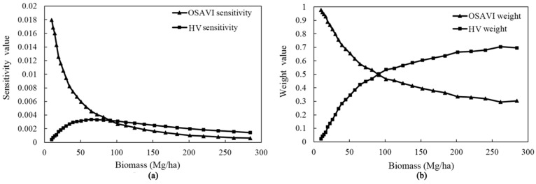
Estimation of forest aboveground biomass is critical for regional carbon policies and sustainable forest management. Passive optical remote sensing and active microwave remote sensing both play an important role in the monitoring of forest biomass. However, optical spectral reflectance is saturated in relatively dense vegetation areas, and microwave backscattering is significantly influenced by the underlying soil when the vegetation coverage is low. Both of these conditions decrease the estimation accuracy of forest biomass. A new optical and microwave integrated vegetation index (VI) was proposed based on observations from both field experiments and satellite (Landsat 8 Operational Land Imager (OLI) and RADARSAT-2) data. According to the difference in interaction between the multispectral reflectance and microwave backscattering signatures with biomass, the combined VI (COVI) was designed using the weighted optical optimized soil-adjusted vegetation index (OSAVI) and microwave horizontally transmitted and vertically received signal (HV) to overcome the disadvantages of both data types. The performance of the COVI was evaluated by comparison with those of the sole optical data, Synthetic Aperture Radar (SAR) data, and the simple combination of independent optical and SAR variables. The most accurate performance was obtained by the models based on the COVI and optical and microwave optimal variables excluding OSAVI and HV, in combination with a random forest algorithm and the largest number of reference samples. The results also revealed that the predictive accuracy depended highly on the statistical method and the number of sample units. The validation indicated that this integrated method of determining the new VI is a good synergistic way to combine both optical and microwave information for the accurate estimation of forest biomass.
Overview
The claims and statistics of this paper haven’t been checked yet.
Run the check — free, no account needed. It reads the open-access text and checks the sources it cites.
Integrity signals
Registry
Cites
Statistics
Figures
Verification
Claims the paper makes
The claims and statistics of this paper haven’t been checked yet.
Run the check — free, no account needed. It reads the open-access text and checks the sources it cites.
Claims other papers make about this one
Each is checked against this paper’s own text: does it say what the citing paper says it does?
The check wasn’t confident either way, so it gives no verdict — never disputed.
In the citing paper
“This is noteworthy because these tasks involve earth observation applications like land use classification using the CORINE Land Cover product [47], heavily focused on forest and crop classification, which are tasks associated with strong seasonality.”
From Prithvi-EO-2.0: A Versatile Multitemporal Foundation Model for Earth Observation Applications (2026) · cites this paper as [47]
Experimental — accuracy not yet measured
Self-check
Percentages, sums and reported differences re-computed from the paper’s own numbers.
The self-check needs the paper’s full text.
Citations
The citation lists are queued
They are fetched later and appear here then.
References 62 · Cited by 105
Research works printed but not linked: 57
- Houghton, R.A., Hall, F., and Goetz, S.J. (2009). Importance of biomass in the global carbon cycle. J. Geophys. Res., 114. · DOI
- Gibbs, 2007, Monitoring and estimating tropical forest carbon stocks: Making REDD a reality, Environ. Res. Lett., 2, 439, 10.1088/1748-9326/2/4/045023 · DOI · Paper page
- Koch, 2010, Status and future of laser scanning, synthetic aperture radar and hyperspectral remote sensing data for forest biomass assessment, ISPRS J. Photogramm. Remote Sens., 65, 581, 10.1016/j.isprsjprs.2010.09.001 · DOI
- Tanase, 2014, Airborne Multi Temporal L-band Polarimetric SAR Data for Biomass Estimation in Semi-Arid Forests, Remote Sens. Environ., 145, 93, 10.1016/j.rse.2014.01.024 · DOI
- Gobakken, 2013, Comparison of precision of biomass estimates in regional field sample surveys and airborne LiDAR-assisted surveys in Hedmark County, Norway, Remote Sens. Environ., 130, 108, 10.1016/j.rse.2012.11.010 · DOI
- Morel, 2012, Evaluating the potential to monitor aboveground biomass in forest and oil palm in Sabah, Malaysia, for 2000–2008 with Landsat ETM+ and ALOS-PALSAR, Int. J. Remote Sens., 33, 3614, 10.1080/01431161.2011.631949 · DOI
- Saatchi, 2011, Impact of spatial variability of tropical forest structure on radar estimation of aboveground biomass, Remote Sen. Environ., 115, 2836, 10.1016/j.rse.2010.07.015 · DOI
- Li, 2007, Regression and analytical models for estimating mangrove wetland biomass in South China using Radarsat images, Int. J. Remote Sens., 28, 5567, 10.1080/01431160701227638 · DOI
- Gleason, 2013, A Review of Remote Sensing of Forest Biomass and Biofuel: Options for Small-Area Applications, Gisci. Remote Sens., 48, 141, 10.2747/1548-1603.48.2.141 · DOI
- Lu, 2005, Aboveground biomass estimation using Landsat TM data in the Brazilian Amazon, Int. J. Remote Sens., 26, 2509, 10.1080/01431160500142145 · DOI
- Mutanga, 2012, High density biomass estimation for wetland vegetation using WorldView-2 imagery and random forest regression algorithm, Int. J. Appl. Earth Observ. Geoinf., 18, 399
- Dobson, 1992, Dependence of radar backscatter on conifer forest biomass, IEEE Trans. Geosci. Remote Sens., 30, 412, 10.1109/36.134090 · DOI
- Sandberg, 2011, L- and P-band backscatter intensity for biomass retrieval in hemiboreal forest, Remote Sens. Environ., 115, 2874, 10.1016/j.rse.2010.03.018 · DOI
- Castel, 2001, Sensitivity of space-borne SAR data to forest parameters over sloping terrain. Theory and experiment, Int. J. Remote Sens., 22, 2351, 10.1080/01431160121407 · DOI
- Gao, 2013, Estimating the Leaf Area Index, height and biomass of maize using HJ-1 and RADARSAT-2, Int. J. Appl. Earth Observ. Geoinf., 24, 1
- Ulaby, 1984, Relating the microwave backscattering coefficient to leaf area index, Remote Sens. Environ., 14, 113, 10.1016/0034-4257(84)90010-5 · DOI
- Inoue, 2002, Season-long daily measurements of multifrequency (Ka, Ku, X, C, and L) and full-polarization backscatter signatures over paddy rice field and their relationship with biological variables, Remote Sens. Environ., 81, 194, 10.1016/S0034-4257(01)00343-1 · DOI
- Mitchard, 2011, Measuring biomass changes due to woody encroachment and deforestation/degradation in a forest–savanna boundary region of central Africa using multi-temporal L-band radar backscatter, Remote Sens. Environ., 115, 2861, 10.1016/j.rse.2010.02.022 · DOI
- Rahman, 2012, Retrieval of tropical forest biomass information from ALOS PALSAR data, Geocarto Int., 28, 382, 10.1080/10106049.2012.710652 · DOI
- Carreiras, 2012, Understanding the relationship between aboveground biomass and ALOS PALSAR data in the forests of Guinea-Bissau (West Africa), Remote Sens. Environ., 121, 426, 10.1016/j.rse.2012.02.012 · DOI
- Chand, 2007, Analysis of ENVISAT ASAR data for forest parameter retrieval and forest type classification—A case study over deciduous forests of central India, Int. J. Remote Sens., 28, 4985, 10.1080/01431160701253295 · DOI
- Cougo, 2015, Radarsat-2 Backscattering for the Modeling of Biophysical Parameters of Regenerating Mangrove Forests, Remote Sens., 7, 17097, 10.3390/rs71215873 · DOI
- He, 2012, Forest stand biomass estimation using ALOS PALSAR data based on LiDAR-derived prior knowledge in the Qilian Mountain, western China, Int. J. Remote Sens., 33, 710, 10.1080/01431161.2011.577829 · DOI
- Montesano, 2013, Achieving accuracy requirements for forest biomass mapping: A spaceborne data fusion method for estimating forest biomass and LiDAR sampling error, Remote Sens. Environ., 130, 153, 10.1016/j.rse.2012.11.016 · DOI
- Gobakken, 2008, Estimation of above- and below-ground biomass across regions of the boreal forest zone using airborne laser, Remote Sens. Environ., 112, 3079, 10.1016/j.rse.2008.03.004 · DOI
- Zhao, 2009, Lidar remote sensing of forest biomass: A scale-invariant estimation approach using airborne lasers, Remote Sens. Environ., 113, 182, 10.1016/j.rse.2008.09.009 · DOI
- Mitchard, 2011, Mapping tropical forest biomass with radar and spaceborne LiDAR in Lopé National Park, Gabon: Overcoming problems of high biomass and persistent cloud, Biogeosciences, 8, 1
- Boudreau, 2008, Regional aboveground forest biomass using airborne and spaceborne LiDAR in Québec, Remote Sens. Environ., 112, 3876, 10.1016/j.rse.2008.06.003 · DOI
- Attarchi, 2014, Improving the Estimation of Above Ground Biomass Using Dual Polarimetric PALSAR and ETM+ Data in the Hyrcanian Mountain Forest (Iran), Remote Sens., 6, 3693, 10.3390/rs6053693 · DOI
- Hame, 2013, Improved Mapping of Tropical Forests With Optical and SAR Imagery, Part II: Above Ground Biomass Estimation, IEEE J. Sel. Top. Appl. Earth Observ. Remote Sens., 6, 92, 10.1109/JSTARS.2013.2241020 · DOI
- Laurin, 2013, Optical and SAR sensor synergies for forest and land cover mapping in a tropical site in West Africa, Int. J. Appl. Earth Observ. Geoinf., 21, 7
- Filippi, 2014, Estimation of floodplain aboveground biomass using multispectral remote sensing and nonparametric modeling, Int. J. Appl. Earth Observ. Geoinf., 33, 119
- Dube, 2015, Evaluating the utility of the medium-spatial resolution Landsat 8 multispectral sensor in quantifying aboveground biomass in uMgeni catchment, South Africa, ISPRS J. Photogramm. Remote Sens., 101, 36, 10.1016/j.isprsjprs.2014.11.001 · DOI
- Fassnacht, 2014, Importance of sample size, data type and prediction method for remote sensing-based estimations of aboveground forest biomass, Remote Sens. Environ., 154, 102, 10.1016/j.rse.2014.07.028 · DOI
- Kattenborn, 2015, Mapping forest biomass from space—Fusion of hyperspectral EO1-hyperion data and Tandem-X and WorldView-2 canopy height models, Int. J. Appl. Earth Observ. Geoinf., 35, 359
- Latifi, 2010, Non-parametric prediction and mapping of standing timber volume and biomass in a temperate forest: Application of multiple optical/LiDAR-derived predictors, Forestry, 83, 395, 10.1093/forestry/cpq022 · DOI
- Tian, 2014, Estimating montane forest above-ground biomass in the upper reaches of the Heihe River Basin using Landsat-TM data, Int. J. Remote Sens., 35, 7339, 10.1080/01431161.2014.967888 · DOI
- Chen, 2015, Spatio-temporal prediction of leaf area index of rubber plantation using HJ-1A/1B CCD images and recurrent neural network, ISPRS J. Photogramm. Remote Sens., 102, 148, 10.1016/j.isprsjprs.2014.12.011 · DOI
- Bright, 2012, Estimating aboveground carbon stocks of a forest affected by mountain pine beetle in Idaho using lidar and multispectral imagery, Remote Sens. Environ., 124, 270, 10.1016/j.rse.2012.05.016 · DOI
- Lu, 2006, The Potential and Challenge of Remote Sensing–Based Biomass Estimation, Int. J. Remote Sens., 27, 1297, 10.1080/01431160500486732 · DOI
- Breiman, 2001, Random Forests, Mach. Learn., 45, 5, 10.1023/A:1010933404324 · DOI · Paper page
- Pal, 2005, Random forest classifier for remote sensing classification, Int. J. Remote Sens., 26, 217, 10.1080/01431160412331269698 · DOI
- Latifi, 2012, Evaluation of most similar neighbour and random forest methods for imputing forest inventory variables using data from target and auxiliary stands, Int. J. Remote Sens., 33, 6668, 10.1080/01431161.2012.693969 · DOI
- Gu, 2006, Estimation of forest volumes by integrating Landsat TM imagery and forest inventory data, Sci. China, 49, 54, 10.1007/s11431-006-8107-z · DOI
- Chirici, 2008, Non-parametric and parametric methods using satellite images for estimating growing stock volume in alpine and Mediterranean forest ecosystems, Remote Sens. Environ., 112, 2686, 10.1016/j.rse.2008.01.002 · DOI
- Mcroberts, 2007, Remote sensing support for national forest inventories, Remote Sens. Environ., 110, 412, 10.1016/j.rse.2006.09.034 · DOI
- Monnet, 2011, Support Vector Regression for the Estimation of Forest Stand Parameters Using Airborne Laser Scanning, IEEE Geosci. Remote Sens. Lett., 8, 580, 10.1109/LGRS.2010.2094179 · DOI
- Verrelst, 2012, Machine learning regression algorithms for biophysical parameter retrieval: Opportunities for Sentinel-2 and -3, Remote Sens. Environ., 118, 127, 10.1016/j.rse.2011.11.002 · DOI
- Tuia, 2011, Multioutput Support Vector Regression for Remote Sensing Biophysical Parameter Estimation, IEEE Geosci. Remote Sens. Lett., 8, 804, 10.1109/LGRS.2011.2109934 · DOI
- Bruzzone, 2006, Robust support vector regression for biophysical variable estimation from remotely sensed images, IEEE Geosci. Remote Sens. Lett., 3, 339, 10.1109/LGRS.2006.871748 · DOI
- Panda, 2010, Application of vegetation indices for agricultural crop yield prediction using neural network techniques, Remote Sens., 2, 673, 10.3390/rs2030673 · DOI
- Zheng, 2013, Retrieval of forest growing stock volume by two different methods using Landsat TM images, Int. J. Remote Sens., 35, 29, 10.1080/01431161.2013.860567 · DOI
- Chang, K.T., Liang, L.S., Yiu, F.G., and Wang, R.Y. (2012, January 22–27). Estimation of carbon sequestration by using vegetation indices. Proceedings of the 2012 IEEE International Geoscience and Remote Sensing Symposium (IGARSS), Munich, Germany. · DOI
- Johnson, 2001, An Introduction to the Bootstrap, Macromol. Crystallogr., 23, 49
- Deng, 2014, Estimating Forest Aboveground Biomass by Combining ALOS PALSAR and WorldView-2 Data: A Case Study at Purple Mountain National Park, Nanjing, China, Remote Sens., 6, 7878, 10.3390/rs6097878 · DOI
- Basuki, 2013, Estimating tropical forest biomass more accurately by integrating ALOS PALSAR and Landsat-7 ETM+ data, Int. J. Remote Sens., 34, 4871, 10.1080/01431161.2013.777486 · DOI
- Laurin, 2014, Above ground biomass estimation in an African tropical forest with lidar and hyperspectral data, ISPRS J. Photogramm. Remote Sens., 89, 49, 10.1016/j.isprsjprs.2014.01.001 · DOI
Metadata
- Authors
- Shao, Z., & Zhang, L.
- Affiliations
- Wuhan University (CN)
- Corresponding author
- Zhang, Linjing
- Venue
- Sensors
- Publisher
- MDPI AG
- Published
- 2016-06-07
- Volume
- 16
- Issue
- 6
- Pages
- 834
- ISSN
- 1424-8220 (ISSN-L)
- PMC
- PMC4934260
- OpenAlex
- W2414762761
- Cited by
- 105
- References
- 62
- Citations by year
- 2026: 7 · 2025: 9 · 2024: 12 · 2023: 11 · 2022: 8 · 2021: 11 · 2020: 16 · 2019: 17 · 2018: 12 · 2017: 2
- FWCI
- 6.45
- Type
- journal article
- Language
- en
- Open access
- gold
- doi.org
- Licence
- Locations
- Sensors (publishedVersion, cc-by)
- Europe PMC (PubMed Central) (publishedVersion, cc-by)
- PubMed Central (publishedVersion, cc-by)
- PubMed (publishedVersion)
- DOAJ (DOAJ: Directory of Open Access Journals) (submittedVersion, cc-by-sa)
- Funders
- National 973 Basic Research and Development Program project (No. 2012CB719904)
- Program for New Century Excellent Talents in University (No. NCET-12-0426)
- Surveying and mapping fund project of National surveying and mapping Geographic Information Bureau ([2015]No.19)
- Topics
- Life Sciences › Agricultural and Biological Sciences › Forestry › Remote Sensing and LiDAR Applications
- Physical Sciences › Earth and Planetary Sciences › Geophysics › Synthetic Aperture Radar (SAR) Applications and Techniques
- Physical Sciences › Environmental Science › Ecology › Remote Sensing in Agriculture
- Keywords
- forest aboveground biomass, SAR-optical data fusion, soil-adjusted vegetation index, microwave backscatter, Landsat 8 OLI, RADARSAT-2, random forest, biomass estimation accuracy
About these checks
Registry, retraction, Cites and statistics results are computed, not judged, with one exception: a printed reference that no index lists is read once by a model before it counts as a citation error. Claims are extracted by a model and kept only when their quote appears verbatim in the text; each cited source is then checked, with a model’s help, for whether it says what the claim relies on. Those verdicts can be wrong — read the claim’s quote and the cited source before relying on one.
Statistics and arithmetic are recomputed, not judged.
Confidence bands are shown only for fields calibrated on our annotated test set. None is calibrated yet, so no band is shown.
What counts as a claim ›How we measure confidence ›How we check this ›
Are you an author, or do you see a problem with this page? Request a review
How to cite
Cite CoChat for the checks on this page, and the paper for its own findings.
- This page
- CoChat. (2026). Citation check: Estimating Forest Aboveground Biomass by Combining Optical and SAR Data: A Case Study in Genhe, Inner Mongolia, China. https://app.cochat.ai/papers/10.3390/s16060834
- The paper
- Shao, Z., & Zhang, L. (2016). Estimating Forest Aboveground Biomass by Combining Optical and SAR Data: A Case Study in Genhe, Inner Mongolia, China. Sensors. https://doi.org/10.3390/s16060834
