

The DOI matches its Crossref record, with a small difference in title or year; 15 of the 15 references it cites were found in a registry or an index; none of the 25 sources its claims cite is checked for support yet.
¿Se hace camino al andar? Influencia de las variables medioambientales y culturales en el cálculo de caminos óptimos mediante SIG
Open accessAbstract
Entre los recientes estudios dentro de la Arqueología del Paisaje, uno de los aspectos que presenta mayor potencial interpretativo es el análisis de la relación entre sus distintos componentes naturales y culturales: la articulación del paisaje – con la identificación de las prácticas sociales que se realizarían en torno a estos elementos y de las pautas de movimiento entre unos y otros. Este movimiento dependería tanto de las características naturales del terreno como de decisiones prácticas de carácter socio-cultural. A partir del estudio de la distribución del poblamiento y abrigos con arte rupestre neolíticos en las tierras centro-meridionales valencianas, se propone un sistema para la introducción y valoración del papel de los componentes culturales del paisaje en el cálculo de caminos óptimos mediante Sistemas de Información Geográfica.
Overview
AI snapshot
Written from the paper’s full text.
TL;DR
This paper uses GIS least-cost path analysis to test how environmental and cultural variables shaped movement in the Neolithic of central-southern Valencia. It finds that adding rock-art shelters as cultural attractors changes optimal routes, often away from naturally easiest corridors, suggesting rock-art places acted as destinations that generated culturally motivated paths.
Key findings
- With only environmental variables (slope, river friction, blocked Estret de l’Infern), routes avoid S–N transit, skirt major obstacles via the SW/NW corridors (Vinalopó, Almansa, Montesa), and do not follow the coast; SO–NE movement is channeled through valleys such as Canal Ibi-Alcoi, Beneixama–Bocairent–Valleta d’Agres, and either Vall de Gallinera or Vall de Seta–Barranc de Famorca–río Xaló/Gorgos.
- Adding Macroesquematic rock-art shelters as attraction shifts routes to Canal Ibi-Alcoi and Barranc de Malafí, producing shorter but more abrupt interior SE–NO paths; Esquematic shelters shift routes to Barranc de Bocairent, Barranc de Malafí, and Barranc de l’Encantà–Vall d’Alcalà–Vall d’Ebo; Levantine shelters produce few changes relative to Esquematic and exclude the Clariano.
- Only the Vall de Gallinera and Barranc de Famorca show coincidence between naturally optimal routes and rock-art shelter distribution; Barranc de l’Infern shelters never relate to computed routes and are interpreted as destinations rather than passage points.
- Some computed routes coincide with later Iberian-period routes, suggesting possible fossilization of Neolithic paths; the paper notes this is harder to explain for abrupt routes such as Barranc de Malafí.
Methods
- Study area: central-southern País Valenciano, Neolithic IA/cardial and IB/postcardial horizons; known habitat sites, caves/shelters, and rock-art shelters of three styles (Macroesquemático, Esquemático, Levantino).
- GIS: ArcView 3.2; DEM from 20-m contours with 30-m resolution; cost surface built by manual reclassification of slope into effort classes, adding river friction values and an artificial barrier at Estret de l’Infern; cultural scenarios added attraction areas around rock-art shelters.
- Least-cost paths computed between peripheral known habitat sites; results compared with archaeological site distribution, current movement knowledge, and later documented routes because no Neolithic routes are documented.
Limitations
- Stated: exploratory study; calculations use only a simple equation assuming effort increases proportionally with slope; better movement algorithms and natural variables such as vegetation or soil types could improve results, but paleoenvironmental data are too general and come from a reduced set of sites.
- Stated: no documented Neolithic communication routes exist, so results are contrasted with current knowledge and site distribution rather than independent Neolithic evidence.
- Evident: cultural attraction values for rock-art shelters are manually assigned and not empirically calibrated; validation relies on modern/current movement and later historical routes.
Model-written summary. Check it against the paper before relying on it.
Integrity signals
Registry
Cites
Statistics
Figures
Verification
Claims the paper makes
34 Own interpretation · 17 No basis given · 13 Sources not found · 9 Own result · 6 Not checked yet · 3 Own method · 2 No full text of the sources
The paper states this without a source or data behind it here, so there is nothing to check it against. The quote shows it is in the paper.
In the paper
“Por otro lado, la comunicación con la zona de la Safor ya no se realiza rodeando este territorio, a través del corredor de Montesa, sino que se canalizaría por el interior.”
§ ¿SE HACE CAMINO AL ANDAR? INFLUENCIA DE LAS VARIABLES MEDIOAMBIENTALES Y CULTURALES EN EL CÁLCULO DE CAMINOS ÓPTIMOS MEDIANTE SIG IS THERE ANY WAY OUT THERE? ENVIRONMENTAL AND CULTURAL INFLUENCES IN COMPUTING LEAST-COST PATHS WITH GIS > 3.2. Variables culturales
hedgeddirect- Asserted: passes — The authors put it forward as true.
- Checkable: passes — It can be checked against evidence.
- Load-bearing: passes — The paper’s conclusions depend on it.
- Based: passes — The paper gives a reason why it holds.
The paper states this without a source or data behind it here, so there is nothing to check it against. The quote shows it is in the paper.
In the paper
“El trazado de estas vías potenciales de comunicación estaría condicionado únicamente por variables medioambientales, mostrando los valles que favorecerían el tránsito con un menor esfuerzo si únicamente se atendiese a los atributos naturales del terreno descritos (pendientes topográficas y cursos de agua).”
§ ¿SE HACE CAMINO AL ANDAR? INFLUENCIA DE LAS VARIABLES MEDIOAMBIENTALES Y CULTURALES EN EL CÁLCULO DE CAMINOS ÓPTIMOS MEDIANTE SIG IS THERE ANY WAY OUT THERE? ENVIRONMENTAL AND CULTURAL INFLUENCES IN COMPUTING LEAST-COST PATHS WITH GIS > 3.1. Variables medioambientales
hedgeddirect- Asserted: passes — The authors put it forward as true.
- Checkable: passes — It can be checked against evidence.
- Load-bearing: passes — The paper’s conclusions depend on it.
- Based: passes — The paper gives a reason why it holds.
The paper states this without a source or data behind it here, so there is nothing to check it against. The quote shows it is in the paper.
In the paper
“En los casos necesarios para el movimiento en dirección S-N se utilizan pequeños pasos, como el paso del Biscoi para el tránsito entre el corredor de Beneixama y la Foia de Castalla.”
§ ¿SE HACE CAMINO AL ANDAR? INFLUENCIA DE LAS VARIABLES MEDIOAMBIENTALES Y CULTURALES EN EL CÁLCULO DE CAMINOS ÓPTIMOS MEDIANTE SIG IS THERE ANY WAY OUT THERE? ENVIRONMENTAL AND CULTURAL INFLUENCES IN COMPUTING LEAST-COST PATHS WITH GIS > 3.1. Variables medioambientales
plain- Asserted: passes — The authors put it forward as true.
- Checkable: passes — It can be checked against evidence.
- Load-bearing: unclear — It is unclear whether the paper’s conclusions depend on it.
- Based: passes — The paper gives a reason why it holds.
The paper states this without a source or data behind it here, so there is nothing to check it against. The quote shows it is in the paper.
In the paper
“Como pautas generales de este movimiento, podemos señalar que parece evitarse el tránsito en dirección S-N, dada la gran cantidad de obstáculos topográficos que dificultarían el movimiento en este sentido.”
§ ¿SE HACE CAMINO AL ANDAR? INFLUENCIA DE LAS VARIABLES MEDIOAMBIENTALES Y CULTURALES EN EL CÁLCULO DE CAMINOS ÓPTIMOS MEDIANTE SIG IS THERE ANY WAY OUT THERE? ENVIRONMENTAL AND CULTURAL INFLUENCES IN COMPUTING LEAST-COST PATHS WITH GIS > 3.1. Variables medioambientales
hedgedconditional- Asserted: passes — The authors put it forward as true.
- Checkable: passes — It can be checked against evidence.
- Load-bearing: passes — The paper’s conclusions depend on it.
- Based: passes — The paper gives a reason why it holds.
A result the paper reports from its own data — it cites no other source for it, so there is none to check. The quote shows it is in the paper.
In the paper
“Sobre un mismo ejemplo, el trazado óptimo entre la Cova de la Sarsa (Bocairent) y Cova Ampla del Montgó (Xàbia), podían observarse diferencias en el resultado si el cálculo se hacía directamente sobre las pendientes (medidas en grados) o si, por el contrario, estas pendientes se reclasificaban en clases de esfuerzo en función de su grado.”
§ ¿SE HACE CAMINO AL ANDAR? INFLUENCIA DE LAS VARIABLES MEDIOAMBIENTALES Y CULTURALES EN EL CÁLCULO DE CAMINOS ÓPTIMOS MEDIANTE SIG IS THERE ANY WAY OUT THERE? ENVIRONMENTAL AND CULTURAL INFLUENCES IN COMPUTING LEAST-COST PATHS WITH GIS > 3.1. Variables medioambientales
hedgeddirectSingle case- Asserted: passes — The authors put it forward as true.
- Checkable: passes — It can be checked against evidence.
- Load-bearing: passes — The paper’s conclusions depend on it.
- Based: passes — The paper gives a reason why it holds.
A result the paper reports from its own data — it cites no other source for it, so there is none to check. The quote shows it is in the paper.
In the paper
“Los resultados obtenidos de la inclusión de distintos elementos en la superficie de fricción sobre la que se han calculado las potenciales vías de comu-nicación, muestran un abanico de posibilidades para la articulación del territorio relativamente amplio.”
§ ¿SE HACE CAMINO AL ANDAR? INFLUENCIA DE LAS VARIABLES MEDIOAMBIENTALES Y CULTURALES EN EL CÁLCULO DE CAMINOS ÓPTIMOS MEDIANTE SIG IS THERE ANY WAY OUT THERE? ENVIRONMENTAL AND CULTURAL INFLUENCES IN COMPUTING LEAST-COST PATHS WITH GIS > 4. ¿SE HACE CAMINO AL ANDAR? INTERPRETACIÓN HISTÓRICA DE LOS CÁLCULOS INFORMÁTICOS
plaincorrelational- Asserted: passes — The authors put it forward as true.
- Checkable: passes — It can be checked against evidence.
- Load-bearing: passes — The paper’s conclusions depend on it.
- Based: passes — The paper gives a reason why it holds.
A result the paper reports from its own data — it cites no other source for it, so there is none to check. The quote shows it is in the paper.
In the paper
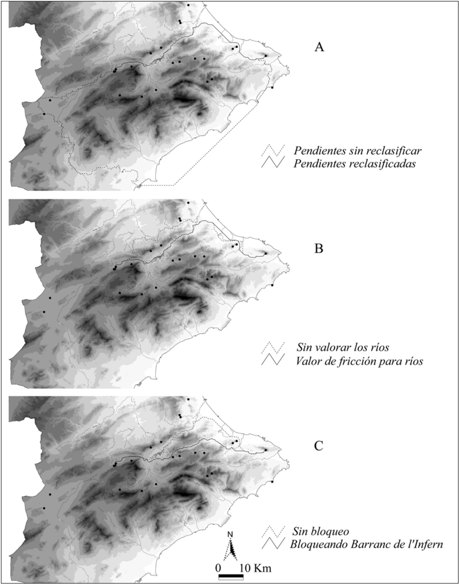
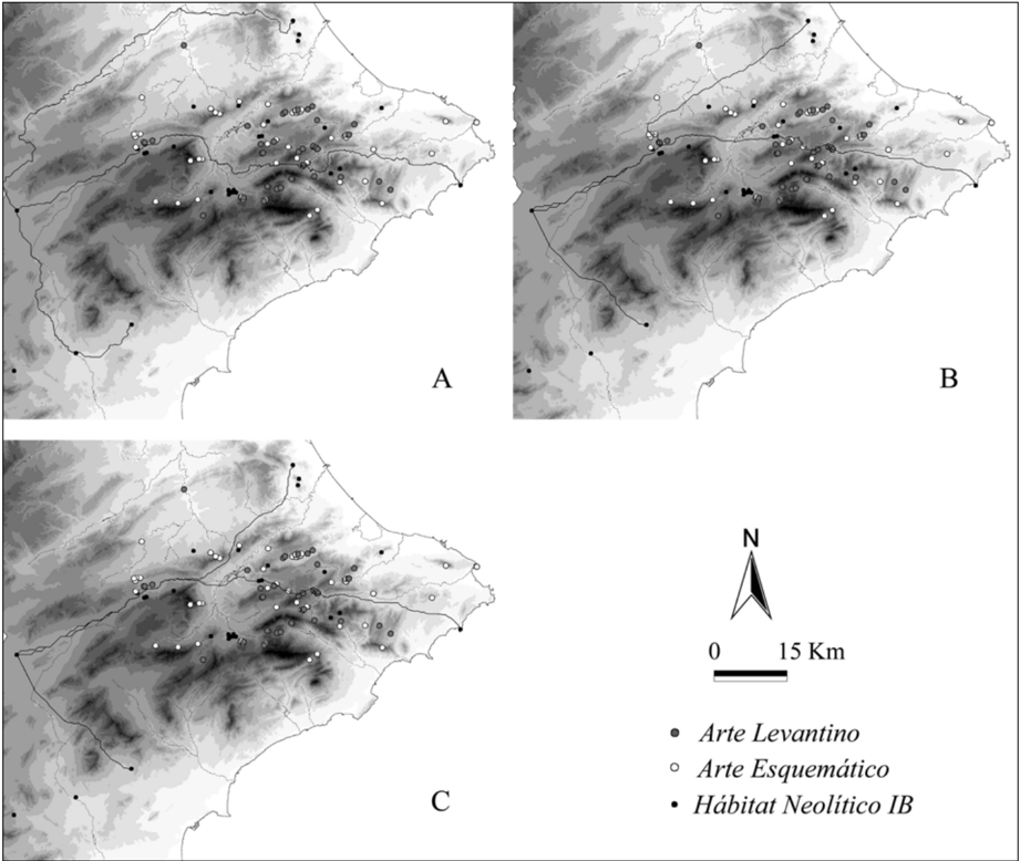
“Finalmente, se estableció una barrera artificial en la estrecha garganta que comunica la cuenca media y baja del río Serpis, hacia donde confluían de forma natural todos los caminos calculados desde puntos situados en el interior de la zona montañosa alicantina hacia el litoral (Fig. 2c).”
§ ¿SE HACE CAMINO AL ANDAR? INFLUENCIA DE LAS VARIABLES MEDIOAMBIENTALES Y CULTURALES EN EL CÁLCULO DE CAMINOS ÓPTIMOS MEDIANTE SIG IS THERE ANY WAY OUT THERE? ENVIRONMENTAL AND CULTURAL INFLUENCES IN COMPUTING LEAST-COST PATHS WITH GIS > 3.1. Variables medioambientales
plain- Asserted: passes — The authors put it forward as true.
- Checkable: passes — It can be checked against evidence.
- Load-bearing: passes — The paper’s conclusions depend on it.
- Based: passes — The paper gives a reason why it holds.
A result the paper reports from its own data — it cites no other source for it, so there is none to check. The quote shows it is in the paper.
In the paper
“En cambio, en esta zona los únicos casos en que existe coincidencia entre los caminos óptimos de acuerdo con los atributos naturales del terreno y la distribución de los abrigos con Arte rupestre son los de la Vall de Gallinera y el Barranc de Famorca;”
§ ¿SE HACE CAMINO AL ANDAR? INFLUENCIA DE LAS VARIABLES MEDIOAMBIENTALES Y CULTURALES EN EL CÁLCULO DE CAMINOS ÓPTIMOS MEDIANTE SIG IS THERE ANY WAY OUT THERE? ENVIRONMENTAL AND CULTURAL INFLUENCES IN COMPUTING LEAST-COST PATHS WITH GIS > 4. ¿SE HACE CAMINO AL ANDAR? INTERPRETACIÓN HISTÓRICA DE LOS CÁLCULOS INFORMÁTICOS
plaincorrelational- Asserted: passes — The authors put it forward as true.
- Checkable: passes — It can be checked against evidence.
- Load-bearing: passes — The paper’s conclusions depend on it.
- Based: passes — The paper gives a reason why it holds.
A result the paper reports from its own data — it cites no other source for it, so there is none to check. The quote shows it is in the paper.
In the paper
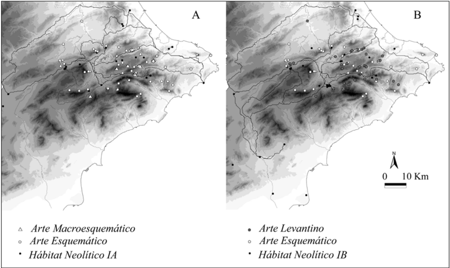
“Esta misma tendencia se mantendría al calcular caminos desde yacimientos del horizonte Neolítico IB (Fig. 5b).”
§ ¿SE HACE CAMINO AL ANDAR? INFLUENCIA DE LAS VARIABLES MEDIOAMBIENTALES Y CULTURALES EN EL CÁLCULO DE CAMINOS ÓPTIMOS MEDIANTE SIG IS THERE ANY WAY OUT THERE? ENVIRONMENTAL AND CULTURAL INFLUENCES IN COMPUTING LEAST-COST PATHS WITH GIS > 3.2. Variables culturales
hedged- Asserted: passes — The authors put it forward as true.
- Checkable: passes — It can be checked against evidence.
- Load-bearing: unclear — It is unclear whether the paper’s conclusions depend on it.
- Based: passes — The paper gives a reason why it holds.
In the paper
“aunque de nuevo podemos encontrar el germen de esta idea en los trabajos de Leroi-Gourhan (1964), quien hizo hincapié en las diferencias presentes entre la percepción del entorno de los cazadores-recolectores, dinámica y basada en el movimiento, y la de los grupos agrícolas, estática y creada en círculos concéntricos que se extienden desde un punto de referencia.”
§ ¿SE HACE CAMINO AL ANDAR? INFLUENCIA DE LAS VARIABLES MEDIOAMBIENTALES Y CULTURALES EN EL CÁLCULO DE CAMINOS ÓPTIMOS MEDIANTE SIG IS THERE ANY WAY OUT THERE? ENVIRONMENTAL AND CULTURAL INFLUENCES IN COMPUTING LEAST-COST PATHS WITH GIS > Abstract
What the sources say
- Not matchedcites Leroi-Gourhan 1964
Couldn’t be matched to a paper in Crossref, so it can’t be checked.
plaincorrelational- Asserted: passes — The authors put it forward as true.
- Checkable: passes — It can be checked against evidence.
- Load-bearing: unclear — It is unclear whether the paper’s conclusions depend on it.
- Based: passes — The paper gives a reason why it holds.
- Not matched
A conclusion the paper draws from its own results — it cites no other source for it, so there is none to check. The quote shows it is in the paper.
In the paper
“Es decir, que son los lugares donde se emplazan los abrigos con Arte rupestre los que tienen un significado cultural que atraería el movimiento y favorecería la creación de nuevas vías de comunicación cuyo trazado incluyera estos núcleos.”
§ ¿SE HACE CAMINO AL ANDAR? INFLUENCIA DE LAS VARIABLES MEDIOAMBIENTALES Y CULTURALES EN EL CÁLCULO DE CAMINOS ÓPTIMOS MEDIANTE SIG IS THERE ANY WAY OUT THERE? ENVIRONMENTAL AND CULTURAL INFLUENCES IN COMPUTING LEAST-COST PATHS WITH GIS > 4. ¿SE HACE CAMINO AL ANDAR? INTERPRETACIÓN HISTÓRICA DE LOS CÁLCULOS INFORMÁTICOS
hedgeddirect- Asserted: passes — The authors put it forward as true.
- Checkable: passes — It can be checked against evidence.
- Load-bearing: passes — The paper’s conclusions depend on it.
- Based: passes — The paper gives a reason why it holds.
A conclusion the paper draws from its own results — it cites no other source for it, so there is none to check. The quote shows it is in the paper.
In the paper
“por el contrario, los demás valles en los que existen destacadas concentraciones de abrigos únicamente se podrían considerar vías potenciales de tránsito si se les otorgase un valor añadido -un valor cultural, como foco de atracción del movimiento-.”
§ ¿SE HACE CAMINO AL ANDAR? INFLUENCIA DE LAS VARIABLES MEDIOAMBIENTALES Y CULTURALES EN EL CÁLCULO DE CAMINOS ÓPTIMOS MEDIANTE SIG IS THERE ANY WAY OUT THERE? ENVIRONMENTAL AND CULTURAL INFLUENCES IN COMPUTING LEAST-COST PATHS WITH GIS > 4. ¿SE HACE CAMINO AL ANDAR? INTERPRETACIÓN HISTÓRICA DE LOS CÁLCULOS INFORMÁTICOS
hedgedconditional- Asserted: passes — The authors put it forward as true.
- Checkable: passes — It can be checked against evidence.
- Load-bearing: passes — The paper’s conclusions depend on it.
- Based: passes — The paper gives a reason why it holds.
A conclusion the paper draws from its own results — it cites no other source for it, so there is none to check. The quote shows it is in the paper.
In the paper
“Éstas podrían ser valoradas como las rutas que facilitarían el desplazamiento en un entorno en el que únicamente existieran obstáculos topográficos y medioambientales; es decir, los corredores naturales que potencialmente permitirían la articulación de este espacio.”
§ ¿SE HACE CAMINO AL ANDAR? INFLUENCIA DE LAS VARIABLES MEDIOAMBIENTALES Y CULTURALES EN EL CÁLCULO DE CAMINOS ÓPTIMOS MEDIANTE SIG IS THERE ANY WAY OUT THERE? ENVIRONMENTAL AND CULTURAL INFLUENCES IN COMPUTING LEAST-COST PATHS WITH GIS > 3.1. Variables medioambientales
hedgedconditional- Asserted: passes — The authors put it forward as true.
- Checkable: passes — It can be checked against evidence.
- Load-bearing: passes — The paper’s conclusions depend on it.
- Based: passes — The paper gives a reason why it holds.
A conclusion the paper draws from its own results — it cites no other source for it, so there is none to check. The quote shows it is in the paper.
In the paper
“Respecto a los abrigos del Barranc de l'Infern, que quedan al margen de estas pautas generales de movimiento, tal vez habría que pensar que su funcionalidad no responde a una asociación a puntos de paso.”
§ ¿SE HACE CAMINO AL ANDAR? INFLUENCIA DE LAS VARIABLES MEDIOAMBIENTALES Y CULTURALES EN EL CÁLCULO DE CAMINOS ÓPTIMOS MEDIANTE SIG IS THERE ANY WAY OUT THERE? ENVIRONMENTAL AND CULTURAL INFLUENCES IN COMPUTING LEAST-COST PATHS WITH GIS > 4. ¿SE HACE CAMINO AL ANDAR? INTERPRETACIÓN HISTÓRICA DE LOS CÁLCULOS INFORMÁTICOS
hedgedSingle case- Asserted: passes — The authors put it forward as true.
- Checkable: passes — It can be checked against evidence.
- Load-bearing: passes — The paper’s conclusions depend on it.
- Based: passes — The paper gives a reason why it holds.
A conclusion the paper draws from its own results — it cites no other source for it, so there is none to check. The quote shows it is in the paper.
In the paper
“De esta manera, serían las prácticas sociales realizadas en torno a estos lugares en los que se representa el arte rupestre las que obligarían a la creación y uso de esos caminos, en una mezcla no siempre equilibrada de factores funcionales y rituales.”
§ ¿SE HACE CAMINO AL ANDAR? INFLUENCIA DE LAS VARIABLES MEDIOAMBIENTALES Y CULTURALES EN EL CÁLCULO DE CAMINOS ÓPTIMOS MEDIANTE SIG IS THERE ANY WAY OUT THERE? ENVIRONMENTAL AND CULTURAL INFLUENCES IN COMPUTING LEAST-COST PATHS WITH GIS > 4. ¿SE HACE CAMINO AL ANDAR? INTERPRETACIÓN HISTÓRICA DE LOS CÁLCULOS INFORMÁTICOS
hedgeddirect- Asserted: passes — The authors put it forward as true.
- Checkable: passes — It can be checked against evidence.
- Load-bearing: passes — The paper’s conclusions depend on it.
- Based: unclear — It is unclear why the paper says it holds.
A conclusion the paper draws from its own results — it cites no other source for it, so there is none to check. The quote shows it is in the paper.
In the paper
“Esta coincidencia, sin embargo, es más difícil de explicar en el caso de otras rutas tan abruptas que en el Neolítico sólo se escogerían si se quisiese pasar cerca de unos abrigos determinados -como es el caso del Barranc de Malafí-.”
§ ¿SE HACE CAMINO AL ANDAR? INFLUENCIA DE LAS VARIABLES MEDIOAMBIENTALES Y CULTURALES EN EL CÁLCULO DE CAMINOS ÓPTIMOS MEDIANTE SIG IS THERE ANY WAY OUT THERE? ENVIRONMENTAL AND CULTURAL INFLUENCES IN COMPUTING LEAST-COST PATHS WITH GIS > 4. ¿SE HACE CAMINO AL ANDAR? INTERPRETACIÓN HISTÓRICA DE LOS CÁLCULOS INFORMÁTICOS
hedgedconditionalSingle case- Asserted: passes — The authors put it forward as true.
- Checkable: passes — It can be checked against evidence.
- Load-bearing: passes — The paper’s conclusions depend on it.
- Based: passes — The paper gives a reason why it holds.
- Rests on an assumption: At least the use of the Barranc de Malafí is documented in historical times.
The paper states this without a source or data behind it here, so there is nothing to check it against. The quote shows it is in the paper.
In the paper
“Hemos señalado que en el área centro-meridional valenciana puede reconocerse desde el inicio de la secuencia neolítica el uso simultáneo de asentamientos al aire libre, cuevas y abrigos.”
§ ¿SE HACE CAMINO AL ANDAR? INFLUENCIA DE LAS VARIABLES MEDIOAMBIENTALES Y CULTURALES EN EL CÁLCULO DE CAMINOS ÓPTIMOS MEDIANTE SIG IS THERE ANY WAY OUT THERE? ENVIRONMENTAL AND CULTURAL INFLUENCES IN COMPUTING LEAST-COST PATHS WITH GIS > Sara Fairén Jiménez
plain- Asserted: passes — The authors put it forward as true.
- Checkable: passes — It can be checked against evidence.
- Load-bearing: unclear — It is unclear whether the paper’s conclusions depend on it.
- Based: passes — The paper gives a reason why it holds.
The paper states this without a source or data behind it here, so there is nothing to check it against. The quote shows it is in the paper.
In the paper
“Sin embargo, en estos estudios la validez de los modelos recreados se supedita en última instancia a su comparación con el trazado de rutas históricas conocidas, o cuya existencia se había documentado previamente.”
§ ¿SE HACE CAMINO AL ANDAR? INFLUENCIA DE LAS VARIABLES MEDIOAMBIENTALES Y CULTURALES EN EL CÁLCULO DE CAMINOS ÓPTIMOS MEDIANTE SIG IS THERE ANY WAY OUT THERE? ENVIRONMENTAL AND CULTURAL INFLUENCES IN COMPUTING LEAST-COST PATHS WITH GIS > Abstract
plain- Asserted: passes — The authors put it forward as true.
- Checkable: passes — It can be checked against evidence.
- Load-bearing: passes — The paper’s conclusions depend on it.
- Based: passes — The paper gives a reason why it holds.
A conclusion the paper draws from its own results — it cites no other source for it, so there is none to check. The quote shows it is in the paper.
In the paper
“De esta manera, se mantendrá el uso de algunas de las potenciales rutas de comunicación neolíticas hasta el momento en que las necesidades del tránsito hagan necesario buscar nuevas opciones viarias”
§ ¿SE HACE CAMINO AL ANDAR? INFLUENCIA DE LAS VARIABLES MEDIOAMBIENTALES Y CULTURALES EN EL CÁLCULO DE CAMINOS ÓPTIMOS MEDIANTE SIG IS THERE ANY WAY OUT THERE? ENVIRONMENTAL AND CULTURAL INFLUENCES IN COMPUTING LEAST-COST PATHS WITH GIS > 4. ¿SE HACE CAMINO AL ANDAR? INTERPRETACIÓN HISTÓRICA DE LOS CÁLCULOS INFORMÁTICOS
plainconditional- Asserted: passes — The authors put it forward as true.
- Checkable: passes — It can be checked against evidence.
- Load-bearing: passes — The paper’s conclusions depend on it.
- Based: passes — The paper gives a reason why it holds.
What the paper did — it cites no source for this, so there is none to check. The quote shows it is in the paper.
In the paper
“Por ello, debe señalarse que estos cálculos se han basado únicamente en una ecuación simple que considera un incremento proporcional del esfuerzo en relación con el valor de la pendiente que debe atravesarse.”
§ ¿SE HACE CAMINO AL ANDAR? INFLUENCIA DE LAS VARIABLES MEDIOAMBIENTALES Y CULTURALES EN EL CÁLCULO DE CAMINOS ÓPTIMOS MEDIANTE SIG IS THERE ANY WAY OUT THERE? ENVIRONMENTAL AND CULTURAL INFLUENCES IN COMPUTING LEAST-COST PATHS WITH GIS > 5. CONCLUSIONES
plaindirect- Asserted: passes — The authors put it forward as true.
- Checkable: passes — It can be checked against evidence.
- Load-bearing: passes — The paper’s conclusions depend on it.
- Based: passes — The paper gives a reason why it holds.
A conclusion the paper draws from its own results — it cites no other source for it, so there is none to check. The quote shows it is in the paper.
In the paper
“Además, el uso de estas rutas culturales favorecerá el desarrollo de unas pautas de movimiento fundamentadas en el hábito, que perdurarán incluso cuando estos abrigos hayan perdido su significado original;”
§ ¿SE HACE CAMINO AL ANDAR? INFLUENCIA DE LAS VARIABLES MEDIOAMBIENTALES Y CULTURALES EN EL CÁLCULO DE CAMINOS ÓPTIMOS MEDIANTE SIG IS THERE ANY WAY OUT THERE? ENVIRONMENTAL AND CULTURAL INFLUENCES IN COMPUTING LEAST-COST PATHS WITH GIS > 4. ¿SE HACE CAMINO AL ANDAR? INTERPRETACIÓN HISTÓRICA DE LOS CÁLCULOS INFORMÁTICOS
hedgeddirect- Asserted: passes — The authors put it forward as true.
- Checkable: passes — It can be checked against evidence.
- Load-bearing: passes — The paper’s conclusions depend on it.
- Based: passes — The paper gives a reason why it holds.
In the paper
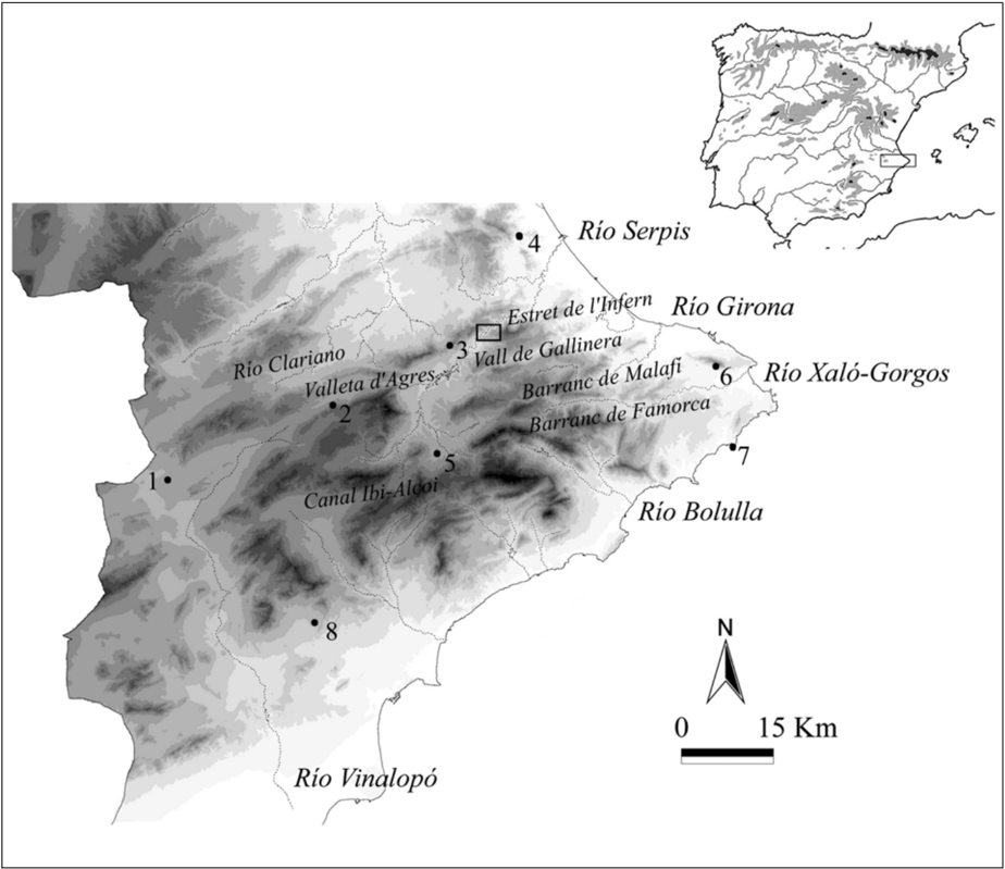
“Se trata de un paisaje caracterizado por una secuencia de pliegues en los que alternan los grandes anticlinales, de naturaleza calcárea y con abundancia de fenómenos kársticos, y las depresiones rellenas de margas miocenas, todos ellos de disposición típicamente bética (SO-NE).”
§ ¿SE HACE CAMINO AL ANDAR? INFLUENCIA DE LAS VARIABLES MEDIOAMBIENTALES Y CULTURALES EN EL CÁLCULO DE CAMINOS ÓPTIMOS MEDIANTE SIG IS THERE ANY WAY OUT THERE? ENVIRONMENTAL AND CULTURAL INFLUENCES IN COMPUTING LEAST-COST PATHS WITH GIS > 2. COMPONENTES NATURALES Y CULTURALES DEL PAISAJE NEOLÍTICO EN LAS TIERRAS CENTRO-MERIDIONALES VALENCIANAS
What the sources say
- Not matchedcites Costa 1985
Couldn’t be matched to a paper in Crossref, so it can’t be checked.
plain- Asserted: passes — The authors put it forward as true.
- Checkable: passes — It can be checked against evidence.
- Load-bearing: unclear — It is unclear whether the paper’s conclusions depend on it.
- Based: passes — The paper gives a reason why it holds.
- Not matched
None of the sources cited for this claim could be matched to a paper in Crossref, so there is nothing to check it against.
In the paper
“Así, frente al paisaje anterior a esta fecha, dominado por un bosque mediterráneo, a partir de estos momentos la acción antrópica sobre esta formación se dejará sentir con más fuerza, con la tala o quema del bosque en busca de pastos y tierras de cultivo dentro de un sistema agrícola de barbecho inestable a medio plazo (Dupré 1988;Bernabeu y Badal 1990).”
§ ¿SE HACE CAMINO AL ANDAR? INFLUENCIA DE LAS VARIABLES MEDIOAMBIENTALES Y CULTURALES EN EL CÁLCULO DE CAMINOS ÓPTIMOS MEDIANTE SIG IS THERE ANY WAY OUT THERE? ENVIRONMENTAL AND CULTURAL INFLUENCES IN COMPUTING LEAST-COST PATHS WITH GIS > 2. COMPONENTES NATURALES Y CULTURALES DEL PAISAJE NEOLÍTICO EN LAS TIERRAS CENTRO-MERIDIONALES VALENCIANAS
What the sources say
- Not matchedcites Dupré 1988
Couldn’t be matched to a paper in Crossref, so it can’t be checked.
- Not matchedcites Bernabeu y Badal 1990
Couldn’t be matched to a paper in Crossref, so it can’t be checked.
plaindirect- Asserted: passes — The authors put it forward as true.
- Checkable: passes — It can be checked against evidence.
- Load-bearing: unclear — It is unclear whether the paper’s conclusions depend on it.
- Based: passes — The paper gives a reason why it holds.
- Not matched
None of the sources cited for this claim could be matched to a paper in Crossref, so there is nothing to check it against.
In the paper
“En cuanto al paisaje vegetal en momentos neolíticos, los estudios antracológicos realizados para algunos yacimientos de la zona muestran cómo desde mediados del VI milenio cal.BC se produce un proceso de degradación del paisaje vegetal.”
§ ¿SE HACE CAMINO AL ANDAR? INFLUENCIA DE LAS VARIABLES MEDIOAMBIENTALES Y CULTURALES EN EL CÁLCULO DE CAMINOS ÓPTIMOS MEDIANTE SIG IS THERE ANY WAY OUT THERE? ENVIRONMENTAL AND CULTURAL INFLUENCES IN COMPUTING LEAST-COST PATHS WITH GIS > 2. COMPONENTES NATURALES Y CULTURALES DEL PAISAJE NEOLÍTICO EN LAS TIERRAS CENTRO-MERIDIONALES VALENCIANAS
What the sources say
- Not matchedcites Dupré 1988
Couldn’t be matched to a paper in Crossref, so it can’t be checked.
- Not matchedcites Bernabeu y Badal 1990
Couldn’t be matched to a paper in Crossref, so it can’t be checked.
plaindirect- Asserted: passes — The authors put it forward as true.
- Checkable: passes — It can be checked against evidence.
- Load-bearing: unclear — It is unclear whether the paper’s conclusions depend on it.
- Based: passes — The paper gives a reason why it holds.
- Not matched
- It may state two separate claims as one. 39
- Probably not a substantial claim. 36
A result the paper reports from its own data — it cites no other source for it, so there is none to check. The quote shows it is in the paper.
In the paper
“Este último caso parecía ser el que mejor se adecuaba a la variabilidad topográfica del área: los caminos resultantes eran menos rectilí-”
- Also stated in: § 3.1. Variables medioambientales · plain
“neos, adecuándose mejor a los pequeños cambios de pendiente del terreno (Fig. 2a).”
§ ¿SE HACE CAMINO AL ANDAR? INFLUENCIA DE LAS VARIABLES MEDIOAMBIENTALES Y CULTURALES EN EL CÁLCULO DE CAMINOS ÓPTIMOS MEDIANTE SIG IS THERE ANY WAY OUT THERE? ENVIRONMENTAL AND CULTURAL INFLUENCES IN COMPUTING LEAST-COST PATHS WITH GIS > 3.1. Variables medioambientales
plaindirectSingle case- Asserted: passes — The authors put it forward as true.
- Checkable: passes — It can be checked against evidence.
- Load-bearing: passes — The paper’s conclusions depend on it.
- Based: passes — The paper gives a reason why it holds.
It may state two separate claims as one.
- Also stated in: § 3.1. Variables medioambientales · plain
The paper states this without a source or data behind it here, so there is nothing to check it against. The quote shows it is in the paper.
In the paper
“En cuanto al movimiento en dirección SO-NE, éste se canaliza por los valles de la zona: hasta la cuenca media del río Serpis por la Canal Ibi-Alcoi y el corredor de Beneixama -Bocairent-Valleta d'Agres; y a partir de ahí existen también dos opciones, la Vall de Gallinera o el eje Vall de Seta -Barranc de Famorca-río Xaló/ Gorgos.”
§ ¿SE HACE CAMINO AL ANDAR? INFLUENCIA DE LAS VARIABLES MEDIOAMBIENTALES Y CULTURALES EN EL CÁLCULO DE CAMINOS ÓPTIMOS MEDIANTE SIG IS THERE ANY WAY OUT THERE? ENVIRONMENTAL AND CULTURAL INFLUENCES IN COMPUTING LEAST-COST PATHS WITH GIS > 3.1. Variables medioambientales
plaindirect- Asserted: passes — The authors put it forward as true.
- Checkable: passes — It can be checked against evidence.
- Load-bearing: passes — The paper’s conclusions depend on it.
- Based: passes — The paper gives a reason why it holds.
It may state two separate claims as one.
A result the paper reports from its own data — it cites no other source for it, so there is none to check. The quote shows it is in the paper.
In the paper
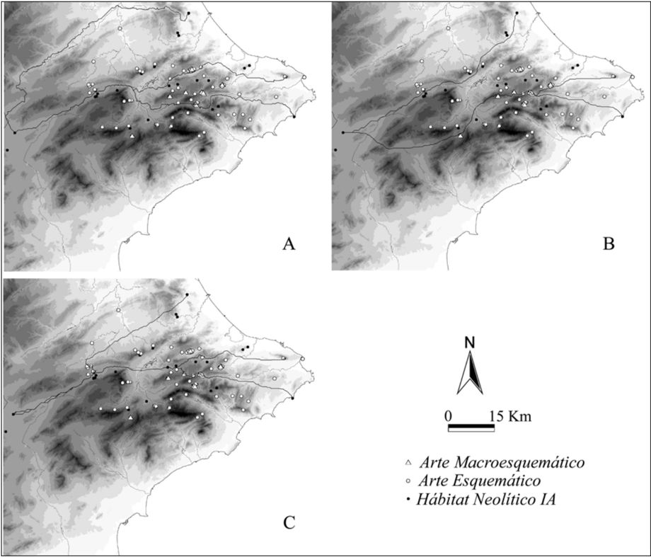
“De esta manera, si se otorga un valor de atracción a los abrigos con Arte rupestre Macroesquemático, vemos cómo se usan dos corredores distintos a los señalados con anterioridad: la Canal Ibi-Alcoi, que comunicaría la cuenca alta del río Vinalopó con la del río Serpis; y el Barranc de Malafí para comunicar la cuenca media del Serpis con las zonas litorales (ver Fig. 4b).”
§ ¿SE HACE CAMINO AL ANDAR? INFLUENCIA DE LAS VARIABLES MEDIOAMBIENTALES Y CULTURALES EN EL CÁLCULO DE CAMINOS ÓPTIMOS MEDIANTE SIG IS THERE ANY WAY OUT THERE? ENVIRONMENTAL AND CULTURAL INFLUENCES IN COMPUTING LEAST-COST PATHS WITH GIS > 3.2. Variables culturales
hedgeddirect- Asserted: passes — The authors put it forward as true.
- Checkable: passes — It can be checked against evidence.
- Load-bearing: passes — The paper’s conclusions depend on it.
- Based: passes — The paper gives a reason why it holds.
It may state two separate claims as one.
The paper states this without a source or data behind it here, so there is nothing to check it against. The quote shows it is in the paper.
In the paper
“Pero además, la introducción en cada caso de abrigos con Arte rupestre Macroesquemático, Esquemático o Levantino no sólo permitía apreciar una variabilidad respecto a las vías potenciales de comunicación obtenidas anteriormente, sino que existían también importantes variaciones en los resultados en cada caso.”
§ ¿SE HACE CAMINO AL ANDAR? INFLUENCIA DE LAS VARIABLES MEDIOAMBIENTALES Y CULTURALES EN EL CÁLCULO DE CAMINOS ÓPTIMOS MEDIANTE SIG IS THERE ANY WAY OUT THERE? ENVIRONMENTAL AND CULTURAL INFLUENCES IN COMPUTING LEAST-COST PATHS WITH GIS > 3.2. Variables culturales
plaindirect- Asserted: passes — The authors put it forward as true.
- Checkable: passes — It can be checked against evidence.
- Load-bearing: passes — The paper’s conclusions depend on it.
- Based: passes — The paper gives a reason why it holds.
It may state two separate claims as one.
The paper states this without a source or data behind it here, so there is nothing to check it against. The quote shows it is in the paper.
In the paper
“Así, los potenciales corredores naturales calculados entre yacimientos situados en los extremos meridional y septentrional del territorio estudiado intentarían rodear los obstáculos topográficos de mayor envergadura, siguiendo los amplios corredores que lo bordean por el SO y NO (cuenca del río Vinalopó, corredor de Almansa y corredor de Montesa), y nunca siguiendo la línea de costa -caracterizada”
§ ¿SE HACE CAMINO AL ANDAR? INFLUENCIA DE LAS VARIABLES MEDIOAMBIENTALES Y CULTURALES EN EL CÁLCULO DE CAMINOS ÓPTIMOS MEDIANTE SIG IS THERE ANY WAY OUT THERE? ENVIRONMENTAL AND CULTURAL INFLUENCES IN COMPUTING LEAST-COST PATHS WITH GIS > 3.1. Variables medioambientales
hedgeddirect- Asserted: passes — The authors put it forward as true.
- Checkable: passes — It can be checked against evidence.
- Load-bearing: passes — The paper’s conclusions depend on it.
- Based: passes — The paper gives a reason why it holds.
It may state two separate claims as one.
A result the paper reports from its own data — it cites no other source for it, so there is none to check. The quote shows it is in the paper.
In the paper
“Respecto a los abrigos con Arte Levantino, su introducción en la superficie de fricción marca en general escasos cambios respecto a los caminos condicionados por los abrigos con Arte Esquemático -aunque debe destacarse que en este caso no se incluye el curso del río Clariano como potencial vía de comunicación, confirmando que se trata de un espacio exclusivamente esquemático (Fig. 5c)-.”
§ ¿SE HACE CAMINO AL ANDAR? INFLUENCIA DE LAS VARIABLES MEDIOAMBIENTALES Y CULTURALES EN EL CÁLCULO DE CAMINOS ÓPTIMOS MEDIANTE SIG IS THERE ANY WAY OUT THERE? ENVIRONMENTAL AND CULTURAL INFLUENCES IN COMPUTING LEAST-COST PATHS WITH GIS > 3.2. Variables culturales
plain- Asserted: passes — The authors put it forward as true.
- Checkable: passes — It can be checked against evidence.
- Load-bearing: passes — The paper’s conclusions depend on it.
- Based: passes — The paper gives a reason why it holds.
It may state two separate claims as one.
A result the paper reports from its own data — it cites no other source for it, so there is none to check. The quote shows it is in the paper.
In the paper
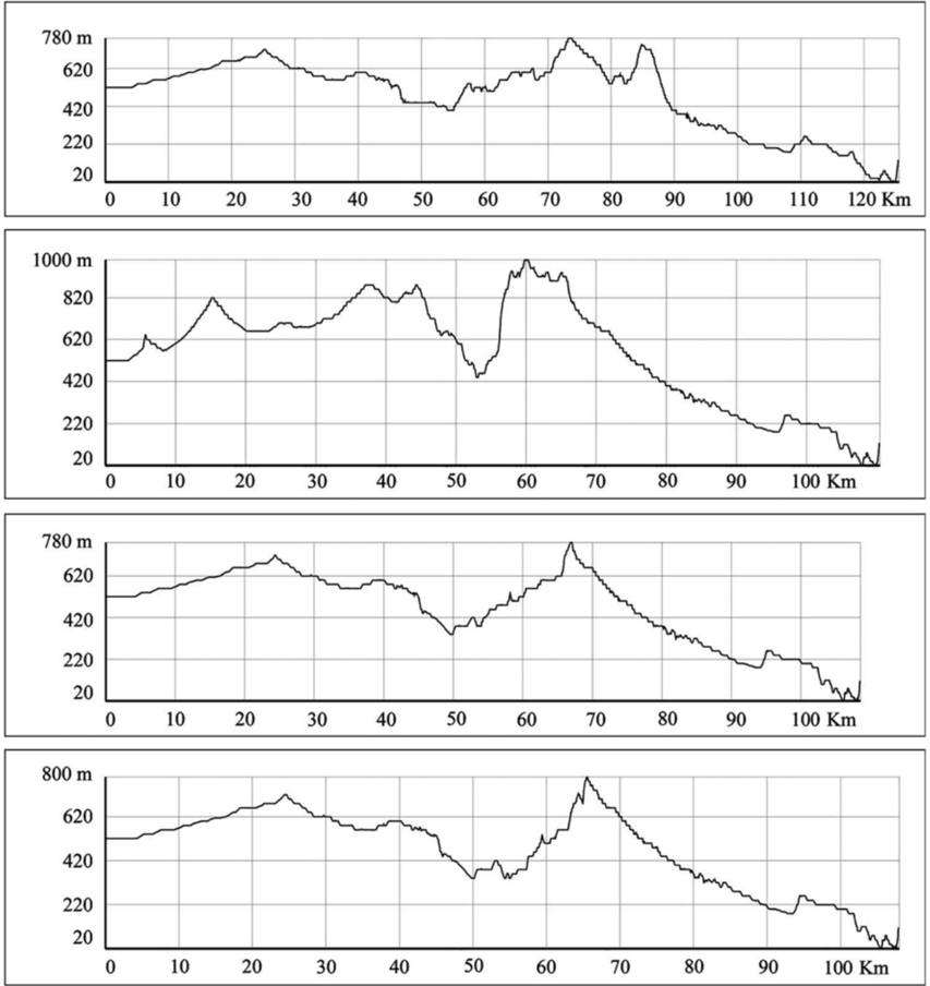
“Estas posibilidades son distintas no sólo respecto a la distancia recorrida sino también en función de los desniveles topográficos que deben atravesarse en cada caso, como puede verse en la Fig. 6.”
§ ¿SE HACE CAMINO AL ANDAR? INFLUENCIA DE LAS VARIABLES MEDIOAMBIENTALES Y CULTURALES EN EL CÁLCULO DE CAMINOS ÓPTIMOS MEDIANTE SIG IS THERE ANY WAY OUT THERE? ENVIRONMENTAL AND CULTURAL INFLUENCES IN COMPUTING LEAST-COST PATHS WITH GIS > 4. ¿SE HACE CAMINO AL ANDAR? INTERPRETACIÓN HISTÓRICA DE LOS CÁLCULOS INFORMÁTICOS
plaincorrelational- Asserted: passes — The authors put it forward as true.
- Checkable: passes — It can be checked against evidence.
- Load-bearing: passes — The paper’s conclusions depend on it.
- Based: passes — The paper gives a reason why it holds.
It may state two separate claims as one.
In the paper
“De acuerdo con este concepto, los paisajes sociales representarían sistemas de referencia para la acción humana, inteligible en el contexto de pasadas y futuras acciones (Gosden y Head 1994).”
§ ¿SE HACE CAMINO AL ANDAR? INFLUENCIA DE LAS VARIABLES MEDIOAMBIENTALES Y CULTURALES EN EL CÁLCULO DE CAMINOS ÓPTIMOS MEDIANTE SIG IS THERE ANY WAY OUT THERE? ENVIRONMENTAL AND CULTURAL INFLUENCES IN COMPUTING LEAST-COST PATHS WITH GIS > Abstract
What the sources say
- Not matchedcites Gosden y Head 1994
Couldn’t be matched to a paper in Crossref, so it can’t be checked.
hedged- Asserted: passes — The authors put it forward as true.
- Checkable: fails — It may be too vague to check against evidence.
- Load-bearing: passes — The paper’s conclusions depend on it.
- Based: passes — The paper gives a reason why it holds.
Probably not a substantial claim. It may be too vague to check against evidence.
- Not matched
None of the sources cited for this claim have been checked yet.
In the paper
“Pero, como han hecho notar algunos autores, este tipo de estudios se ven limitados por la carencia de una metodología adecuada para la reconstrucción de la dimensión espacial de las prácticas sociales, su posible relación con los elementos percibidos del paisaje, y la importancia del movimiento en todo ello (Llobera 1996;Harris 2000).”
§ ¿SE HACE CAMINO AL ANDAR? INFLUENCIA DE LAS VARIABLES MEDIOAMBIENTALES Y CULTURALES EN EL CÁLCULO DE CAMINOS ÓPTIMOS MEDIANTE SIG IS THERE ANY WAY OUT THERE? ENVIRONMENTAL AND CULTURAL INFLUENCES IN COMPUTING LEAST-COST PATHS WITH GIS > Abstract
What the sources say
- Not checked — no full text of the sourcecites Llobera 1996 source
- Not matchedcites Harris 2000
Couldn’t be matched to a paper in Crossref, so it can’t be checked.
plain- Asserted: passes — The authors put it forward as true.
- Checkable: passes — It can be checked against evidence.
- Load-bearing: passes — The paper’s conclusions depend on it.
- Based: passes — The paper gives a reason why it holds.
Probably not a substantial claim.
None of the sources cited for this claim have been checked yet.
In the paper
“El estudio del movimiento de los grupos sociales en su entorno es uno de los aspectos fundamen-tales desarrollados por las aproximaciones postprocesuales y fenomenológicas al estudio arqueológico del paisaje, en claro contraste con el carácter estático de los estudios espaciales de carácter procesual.”
§ ¿SE HACE CAMINO AL ANDAR? INFLUENCIA DE LAS VARIABLES MEDIOAMBIENTALES Y CULTURALES EN EL CÁLCULO DE CAMINOS ÓPTIMOS MEDIANTE SIG IS THERE ANY WAY OUT THERE? ENVIRONMENTAL AND CULTURAL INFLUENCES IN COMPUTING LEAST-COST PATHS WITH GIS > Abstract
boostedcorrelational- Asserted: passes — The authors put it forward as true.
- Checkable: passes — It can be checked against evidence.
- Load-bearing: passes — The paper’s conclusions depend on it.
- Based: passes — The paper gives a reason why it holds.
Probably not a substantial claim. It may state two separate claims as one.
In the paper
“Se habla así del paisaje como entorno mediatizado por la percepción subjetiva del individuo y del grupo; es decir, un elemento socialmente construido, domesticado y apropiado por los grupos que lo habitan (Bender 1993).”
§ ¿SE HACE CAMINO AL ANDAR? INFLUENCIA DE LAS VARIABLES MEDIOAMBIENTALES Y CULTURALES EN EL CÁLCULO DE CAMINOS ÓPTIMOS MEDIANTE SIG IS THERE ANY WAY OUT THERE? ENVIRONMENTAL AND CULTURAL INFLUENCES IN COMPUTING LEAST-COST PATHS WITH GIS > Abstract
What the sources say
- Not checked — no full text of the sourcecites Bender 1993
plain- Asserted: passes — The authors put it forward as true.
- Checkable: fails — It may be too vague to check against evidence.
- Load-bearing: passes — The paper’s conclusions depend on it.
- Based: passes — The paper gives a reason why it holds.
Probably not a substantial claim. It may be too vague to check against evidence. It may state two separate claims as one.
A conclusion the paper draws from its own results — it cites no other source for it, so there is none to check. The quote shows it is in the paper.
In the paper
“De esta manera, la presencia de los abrigos macroesquemáticos forzaría una nueva tendencia de movimiento, recorriendo el interior del territorio en dirección SE-NO siguiendo los valles sinclinales, y aprovechando pequeños pasos de montaña para cruzar los obstáculos topográficos de mayor envergadura; los trazados serían así más cortos, pero también más abruptos.”
§ ¿SE HACE CAMINO AL ANDAR? INFLUENCIA DE LAS VARIABLES MEDIOAMBIENTALES Y CULTURALES EN EL CÁLCULO DE CAMINOS ÓPTIMOS MEDIANTE SIG IS THERE ANY WAY OUT THERE? ENVIRONMENTAL AND CULTURAL INFLUENCES IN COMPUTING LEAST-COST PATHS WITH GIS > 3.2. Variables culturales
hedgeddirect- Asserted: passes — The authors put it forward as true.
- Checkable: passes — It can be checked against evidence.
- Load-bearing: passes — The paper’s conclusions depend on it.
- Based: passes — The paper gives a reason why it holds.
It may state two separate claims as one.
A conclusion the paper draws from its own results — it cites no other source for it, so there is none to check. The quote shows it is in the paper.
In the paper
“Estaríamos hablando en este caso de un tránsito no mecanizado, formado por pequeños grupos de personas y animales (fundamentalmente ovicápridos, el elemento más abundante en la cabaña ganadera de estas comunidades).”
§ ¿SE HACE CAMINO AL ANDAR? INFLUENCIA DE LAS VARIABLES MEDIOAMBIENTALES Y CULTURALES EN EL CÁLCULO DE CAMINOS ÓPTIMOS MEDIANTE SIG IS THERE ANY WAY OUT THERE? ENVIRONMENTAL AND CULTURAL INFLUENCES IN COMPUTING LEAST-COST PATHS WITH GIS > Sara Fairén Jiménez
hedged- Asserted: passes — The authors put it forward as true.
- Checkable: passes — It can be checked against evidence.
- Load-bearing: passes — The paper’s conclusions depend on it.
- Based: fails — The paper may give no reason why it holds.
Probably not a substantial claim. The paper may give no reason why it holds. It may state two separate claims as one.
A conclusion the paper draws from its own results — it cites no other source for it, so there is none to check. The quote shows it is in the paper.
In the paper
“Sin embargo, debe remarcarse que en cada caso su uso respondería a unos condicionamientos naturales y socio-culturales particulares: mientras algunos trazados mostrarían una aptitud natural para el tránsito, otros serían más abruptos y la elección de usarlos sólo podría responder a una voluntad que no atendiese al esfuerzo sino a factores de otro tipo.”
§ ¿SE HACE CAMINO AL ANDAR? INFLUENCIA DE LAS VARIABLES MEDIOAMBIENTALES Y CULTURALES EN EL CÁLCULO DE CAMINOS ÓPTIMOS MEDIANTE SIG IS THERE ANY WAY OUT THERE? ENVIRONMENTAL AND CULTURAL INFLUENCES IN COMPUTING LEAST-COST PATHS WITH GIS > 4. ¿SE HACE CAMINO AL ANDAR? INTERPRETACIÓN HISTÓRICA DE LOS CÁLCULOS INFORMÁTICOS
hedgedconditional- Asserted: passes — The authors put it forward as true.
- Checkable: passes — It can be checked against evidence.
- Load-bearing: passes — The paper’s conclusions depend on it.
- Based: passes — The paper gives a reason why it holds.
Probably not a substantial claim. It may state two separate claims as one.
A conclusion the paper draws from its own results — it cites no other source for it, so there is none to check. The quote shows it is in the paper.
In the paper
“De esta manera, la coincidencia entre las vías usadas en época neolítica y momentos posteriores sería lógica en el caso de aquellas rutas consideradas óptimas de acuerdo con los condicio-namientos naturales del terreno; pues, mientras no cambiasen las condiciones en que se produce el movimiento, se mantendrían sus posibilidades de uso: este sería el caso de las rutas señaladas en la Vall de Gallin”
§ ¿SE HACE CAMINO AL ANDAR? INFLUENCIA DE LAS VARIABLES MEDIOAMBIENTALES Y CULTURALES EN EL CÁLCULO DE CAMINOS ÓPTIMOS MEDIANTE SIG IS THERE ANY WAY OUT THERE? ENVIRONMENTAL AND CULTURAL INFLUENCES IN COMPUTING LEAST-COST PATHS WITH GIS > 4. ¿SE HACE CAMINO AL ANDAR? INTERPRETACIÓN HISTÓRICA DE LOS CÁLCULOS INFORMÁTICOS
hedgedconditional- Asserted: passes — The authors put it forward as true.
- Checkable: passes — It can be checked against evidence.
- Load-bearing: passes — The paper’s conclusions depend on it.
- Based: passes — The paper gives a reason why it holds.
It may state two separate claims as one.
A conclusion the paper draws from its own results — it cites no other source for it, so there is none to check. The quote shows it is in the paper.
In the paper
“Por otro lado y a mayor escala, la existencia de varios núcleos de poblamiento en el espacio analizado y de refugios y abrigos con arte rupestre entre ellos, permite también plantear el análisis de la comunicación entre los grupos que habitarían en cada zona; así como la identificación de las pautas de movimiento y prácticas sociales que se llevarían a cabo a larga escala a través de este paisaje”
§ ¿SE HACE CAMINO AL ANDAR? INFLUENCIA DE LAS VARIABLES MEDIOAMBIENTALES Y CULTURALES EN EL CÁLCULO DE CAMINOS ÓPTIMOS MEDIANTE SIG IS THERE ANY WAY OUT THERE? ENVIRONMENTAL AND CULTURAL INFLUENCES IN COMPUTING LEAST-COST PATHS WITH GIS > Sara Fairén Jiménez
plainconditional- Asserted: passes — The authors put it forward as true.
- Checkable: passes — It can be checked against evidence.
- Load-bearing: passes — The paper’s conclusions depend on it.
- Based: passes — The paper gives a reason why it holds.
Probably not a substantial claim. It may state two separate claims as one.
A conclusion the paper draws from its own results — it cites no other source for it, so there is none to check. The quote shows it is in the paper.
In the paper
“La persistencia de este hábito haría que se mantuviera el uso de estos caminos más allá del Neolítico, en momentos en que los abrigos y manifestaciones gráficas que condicionaron su trazado habrían perdido su significación original.”
§ ¿SE HACE CAMINO AL ANDAR? INFLUENCIA DE LAS VARIABLES MEDIOAMBIENTALES Y CULTURALES EN EL CÁLCULO DE CAMINOS ÓPTIMOS MEDIANTE SIG IS THERE ANY WAY OUT THERE? ENVIRONMENTAL AND CULTURAL INFLUENCES IN COMPUTING LEAST-COST PATHS WITH GIS > 4. ¿SE HACE CAMINO AL ANDAR? INTERPRETACIÓN HISTÓRICA DE LOS CÁLCULOS INFORMÁTICOS
hedgeddirect- Asserted: passes — The authors put it forward as true.
- Checkable: passes — It can be checked against evidence.
- Load-bearing: fails — The paper’s conclusions may not depend on it.
- Based: fails — The paper may give no reason why it holds.
Probably not a substantial claim. The paper’s conclusions may not depend on it. The paper may give no reason why it holds.
The paper states this without a source or data behind it here, so there is nothing to check it against. The quote shows it is in the paper.
In the paper
“El poblamiento en esta zona se caracteriza, desde los primeros momentos del Neolítico, por una dualidad entre asentamientos al aire libre y la ocupación de cuevas y abrigos.”
§ ¿SE HACE CAMINO AL ANDAR? INFLUENCIA DE LAS VARIABLES MEDIOAMBIENTALES Y CULTURALES EN EL CÁLCULO DE CAMINOS ÓPTIMOS MEDIANTE SIG IS THERE ANY WAY OUT THERE? ENVIRONMENTAL AND CULTURAL INFLUENCES IN COMPUTING LEAST-COST PATHS WITH GIS > 2. COMPONENTES NATURALES Y CULTURALES DEL PAISAJE NEOLÍTICO EN LAS TIERRAS CENTRO-MERIDIONALES VALENCIANAS
plain- Asserted: passes — The authors put it forward as true.
- Checkable: passes — It can be checked against evidence.
- Load-bearing: fails — The paper’s conclusions may not depend on it.
- Based: passes — The paper gives a reason why it holds.
Probably not a substantial claim. The paper’s conclusions may not depend on it.
The paper states this without a source or data behind it here, so there is nothing to check it against. The quote shows it is in the paper.
In the paper
“En contraste, esta unidad geomorfológica bien definida queda rodeada por una serie de corredores más amplios (la Vall d'Albaida al Norte o el corredor del Vinalopó al Sur), a los que se une bien en dirección N-S mediante estrechos pasos y puertos de montaña, o en dirección SO-NE a través de los sinclinales béticos que siguen los valles.”
§ ¿SE HACE CAMINO AL ANDAR? INFLUENCIA DE LAS VARIABLES MEDIOAMBIENTALES Y CULTURALES EN EL CÁLCULO DE CAMINOS ÓPTIMOS MEDIANTE SIG IS THERE ANY WAY OUT THERE? ENVIRONMENTAL AND CULTURAL INFLUENCES IN COMPUTING LEAST-COST PATHS WITH GIS > 2. COMPONENTES NATURALES Y CULTURALES DEL PAISAJE NEOLÍTICO EN LAS TIERRAS CENTRO-MERIDIONALES VALENCIANAS
boostedcorrelational- Asserted: passes — The authors put it forward as true.
- Checkable: passes — It can be checked against evidence.
- Load-bearing: fails — The paper’s conclusions may not depend on it.
- Based: passes — The paper gives a reason why it holds.
Probably not a substantial claim. The paper’s conclusions may not depend on it. It may state two separate claims as one.
What the paper did — it cites no source for this, so there is none to check. The quote shows it is in the paper.
In the paper
“ante la ausencia de rutas de comunicación documentadas para la época neolítica, los resultados se contrastaron con el conocimiento acerca del movimiento actual en este territorio, así como con la distribución de los yacimientos neolíticos en relación con los caminos obtenidos.”
§ ¿SE HACE CAMINO AL ANDAR? INFLUENCIA DE LAS VARIABLES MEDIOAMBIENTALES Y CULTURALES EN EL CÁLCULO DE CAMINOS ÓPTIMOS MEDIANTE SIG IS THERE ANY WAY OUT THERE? ENVIRONMENTAL AND CULTURAL INFLUENCES IN COMPUTING LEAST-COST PATHS WITH GIS > 3. MOVIMIENTO Y SISTEMAS DE INFORMACIÓN GEOGRÁFICA: EL CÁLCULO DE CAMINOS ÓPTIMOS
plain- Asserted: passes — The authors put it forward as true.
- Checkable: passes — It can be checked against evidence.
- Load-bearing: passes — The paper’s conclusions depend on it.
- Based: passes — The paper gives a reason why it holds.
Probably not a substantial claim.
- Rests on an assumption: La distribución de los yacimientos neolíticos en relación con los caminos obtenidos puede validar los caminos calculados.
In the paper
“Por ello, como señala Harris (2000), sigue existiendo un problema a la hora de analizar el movimiento no documentado en el paisaje, el de los grupos sociales prehistóricos; especialmente en aquellas zonas que por sus características topográficas ofrezcan un amplio abanico de posibilidades para el trazado de caminos óptimos.”
§ ¿SE HACE CAMINO AL ANDAR? INFLUENCIA DE LAS VARIABLES MEDIOAMBIENTALES Y CULTURALES EN EL CÁLCULO DE CAMINOS ÓPTIMOS MEDIANTE SIG IS THERE ANY WAY OUT THERE? ENVIRONMENTAL AND CULTURAL INFLUENCES IN COMPUTING LEAST-COST PATHS WITH GIS > Abstract
What the sources say
- Not matchedcites Harris 2000
Couldn’t be matched to a paper in Crossref, so it can’t be checked.
plain- Asserted: passes — The authors put it forward as true.
- Checkable: passes — It can be checked against evidence.
- Load-bearing: passes — The paper’s conclusions depend on it.
- Based: passes — The paper gives a reason why it holds.
Probably not a substantial claim.
- Not matched
The paper states this without a source or data behind it here, so there is nothing to check it against. The quote shows it is in the paper.
In the paper
“Entre estos dos núcleos de poblamiento se disponen unos valles de orientación SO-NE, a lo largo de los cuales encontramos una serie de cuevas y abrigos cuya escasa potencia estratigráfica pero variedad de materiales reflejaría un uso esporádico pero reiterado a lo largo de toda la secuencia neolítica.”
§ ¿SE HACE CAMINO AL ANDAR? INFLUENCIA DE LAS VARIABLES MEDIOAMBIENTALES Y CULTURALES EN EL CÁLCULO DE CAMINOS ÓPTIMOS MEDIANTE SIG IS THERE ANY WAY OUT THERE? ENVIRONMENTAL AND CULTURAL INFLUENCES IN COMPUTING LEAST-COST PATHS WITH GIS > 2. COMPONENTES NATURALES Y CULTURALES DEL PAISAJE NEOLÍTICO EN LAS TIERRAS CENTRO-MERIDIONALES VALENCIANAS
hedgedcorrelational- Asserted: passes — The authors put it forward as true.
- Checkable: passes — It can be checked against evidence.
- Load-bearing: fails — The paper’s conclusions may not depend on it.
- Based: passes — The paper gives a reason why it holds.
Probably not a substantial claim. The paper’s conclusions may not depend on it.
A conclusion the paper draws from its own results — it cites no other source for it, so there is none to check. The quote shows it is in the paper.
In the paper
“La variabilidad existente en los caminos obtenidos en este estudio de acuerdo con la introducción diferencial de los distintos componentes del paisaje parece apuntar en esta dirección.”
§ ¿SE HACE CAMINO AL ANDAR? INFLUENCIA DE LAS VARIABLES MEDIOAMBIENTALES Y CULTURALES EN EL CÁLCULO DE CAMINOS ÓPTIMOS MEDIANTE SIG IS THERE ANY WAY OUT THERE? ENVIRONMENTAL AND CULTURAL INFLUENCES IN COMPUTING LEAST-COST PATHS WITH GIS > 5. CONCLUSIONES
hedgedcorrelational- Asserted: passes — The authors put it forward as true.
- Checkable: passes — It can be checked against evidence.
- Load-bearing: passes — The paper’s conclusions depend on it.
- Based: passes — The paper gives a reason why it holds.
Probably not a substantial claim.
A conclusion the paper draws from its own results — it cites no other source for it, so there is none to check. The quote shows it is in the paper.
In the paper
“Por ello, el cálculo de caminos óptimos entre yacimientos pertenecientes a estos dos núcleos de poblamiento mediante el SIG ArcView 3.2 permite comprobar en qué medida y en qué circunstancias los valles situados entre ambos núcleos podían considerarse vías potenciales de comunicación.”
§ ¿SE HACE CAMINO AL ANDAR? INFLUENCIA DE LAS VARIABLES MEDIOAMBIENTALES Y CULTURALES EN EL CÁLCULO DE CAMINOS ÓPTIMOS MEDIANTE SIG IS THERE ANY WAY OUT THERE? ENVIRONMENTAL AND CULTURAL INFLUENCES IN COMPUTING LEAST-COST PATHS WITH GIS > Sara Fairén Jiménez
plaincorrelational- Asserted: passes — The authors put it forward as true.
- Checkable: passes — It can be checked against evidence.
- Load-bearing: passes — The paper’s conclusions depend on it.
- Based: passes — The paper gives a reason why it holds.
Probably not a substantial claim.
A conclusion the paper draws from its own results — it cites no other source for it, so there is none to check. The quote shows it is in the paper.
In the paper
“Estos aspectos constituirían la dimensión espacial de la identidad grupal de los grupos prehistóricos.”
§ ¿SE HACE CAMINO AL ANDAR? INFLUENCIA DE LAS VARIABLES MEDIOAMBIENTALES Y CULTURALES EN EL CÁLCULO DE CAMINOS ÓPTIMOS MEDIANTE SIG IS THERE ANY WAY OUT THERE? ENVIRONMENTAL AND CULTURAL INFLUENCES IN COMPUTING LEAST-COST PATHS WITH GIS > 5. CONCLUSIONES
hedged- Asserted: passes — The authors put it forward as true.
- Checkable: fails — It may be too vague to check against evidence.
- Load-bearing: passes — The paper’s conclusions depend on it.
- Based: fails — The paper may give no reason why it holds.
Probably not a substantial claim. It may be too vague to check against evidence. The paper may give no reason why it holds.
The paper states this without a source or data behind it here, so there is nothing to check it against. The quote shows it is in the paper.
In the paper
“Por otro lado, es también a lo largo de estos valles donde encontramos la mayor parte de los yacimientos con Arte rupestre conocidos en esta comarca.”
§ ¿SE HACE CAMINO AL ANDAR? INFLUENCIA DE LAS VARIABLES MEDIOAMBIENTALES Y CULTURALES EN EL CÁLCULO DE CAMINOS ÓPTIMOS MEDIANTE SIG IS THERE ANY WAY OUT THERE? ENVIRONMENTAL AND CULTURAL INFLUENCES IN COMPUTING LEAST-COST PATHS WITH GIS > 2. COMPONENTES NATURALES Y CULTURALES DEL PAISAJE NEOLÍTICO EN LAS TIERRAS CENTRO-MERIDIONALES VALENCIANAS
plaincorrelational- Asserted: passes — The authors put it forward as true.
- Checkable: passes — It can be checked against evidence.
- Load-bearing: fails — The paper’s conclusions may not depend on it.
- Based: passes — The paper gives a reason why it holds.
Probably not a substantial claim. The paper’s conclusions may not depend on it.
A conclusion the paper draws from its own results — it cites no other source for it, so there is none to check. The quote shows it is in the paper.
In the paper
“Así, tal vez la reflexión debiera hacerse a la inversa: en la mayor parte de los casos el arte rupestre no se localiza a lo largo de los corredores más favorables para el tránsito de acuerdo con sus atributos naturales, sino en algunos más abruptos y que presentan mayores dificultades; sin embargo éstos se usan, pero sólo a consecuencia de pasar por unos lugares que tienen una especial significaci”
§ ¿SE HACE CAMINO AL ANDAR? INFLUENCIA DE LAS VARIABLES MEDIOAMBIENTALES Y CULTURALES EN EL CÁLCULO DE CAMINOS ÓPTIMOS MEDIANTE SIG IS THERE ANY WAY OUT THERE? ENVIRONMENTAL AND CULTURAL INFLUENCES IN COMPUTING LEAST-COST PATHS WITH GIS > 4. ¿SE HACE CAMINO AL ANDAR? INTERPRETACIÓN HISTÓRICA DE LOS CÁLCULOS INFORMÁTICOS
hedgeddirect- Asserted: passes — The authors put it forward as true.
- Checkable: passes — It can be checked against evidence.
- Load-bearing: passes — The paper’s conclusions depend on it.
- Based: passes — The paper gives a reason why it holds.
It may state two separate claims as one.
None of the sources cited for this claim have been checked yet.
In the paper
“En estos abrigos se representan motivos pertenecientes a tres estilos distintos, Macroesquemático, Esquemático y Levantino, aunque todos ellos de cronología neolítica si atendemos a sus paralelos muebles y las superposiciones cromáticas (Hernández y Martí 2000-2001;Fairén 2004).”
§ ¿SE HACE CAMINO AL ANDAR? INFLUENCIA DE LAS VARIABLES MEDIOAMBIENTALES Y CULTURALES EN EL CÁLCULO DE CAMINOS ÓPTIMOS MEDIANTE SIG IS THERE ANY WAY OUT THERE? ENVIRONMENTAL AND CULTURAL INFLUENCES IN COMPUTING LEAST-COST PATHS WITH GIS > 2. COMPONENTES NATURALES Y CULTURALES DEL PAISAJE NEOLÍTICO EN LAS TIERRAS CENTRO-MERIDIONALES VALENCIANAS
What the sources say
- Not matchedcites Hernández y Martí 2000-2001
Couldn’t be matched to a paper in Crossref, so it can’t be checked.
- Not checked — no full text of the sourcecites Fairén 2004 source
plain- Asserted: passes — The authors put it forward as true.
- Checkable: passes — It can be checked against evidence.
- Load-bearing: fails — The paper’s conclusions may not depend on it.
- Based: passes — The paper gives a reason why it holds.
Probably not a substantial claim. The paper’s conclusions may not depend on it. It may state two separate claims as one.
- Not matched
A conclusion the paper draws from its own results — it cites no other source for it, so there is none to check. The quote shows it is in the paper.
In the paper
“La zona analizada, por su propia configuración topográfica, ofrece un número relativamente amplio aunque finito de posibilidades para el movimiento; la elección de cada una de estas opciones puede variar en función del modo en que se realice el tránsito (a pie, con ganado, o con carros), pero también y como hemos visto por pautas de decisión de carácter socio-cultural.”
§ ¿SE HACE CAMINO AL ANDAR? INFLUENCIA DE LAS VARIABLES MEDIOAMBIENTALES Y CULTURALES EN EL CÁLCULO DE CAMINOS ÓPTIMOS MEDIANTE SIG IS THERE ANY WAY OUT THERE? ENVIRONMENTAL AND CULTURAL INFLUENCES IN COMPUTING LEAST-COST PATHS WITH GIS > 4. ¿SE HACE CAMINO AL ANDAR? INTERPRETACIÓN HISTÓRICA DE LOS CÁLCULOS INFORMÁTICOS
plainconditional- Asserted: passes — The authors put it forward as true.
- Checkable: passes — It can be checked against evidence.
- Load-bearing: passes — The paper’s conclusions depend on it.
- Based: passes — The paper gives a reason why it holds.
It may state two separate claims as one.
In the paper
“En este sentido, como aporte para la superación de los modelos espaciales funcionalistas de la Arqueología procesual, debe destacarse la propuesta de M. Llobera (2000) de analizar la sociología del movimiento: intentando identificar no caminos concretos sino pautas generales del movimiento, atendiendo a los factores que condicionan su creación, uso y evolución.”
§ ¿SE HACE CAMINO AL ANDAR? INFLUENCIA DE LAS VARIABLES MEDIOAMBIENTALES Y CULTURALES EN EL CÁLCULO DE CAMINOS ÓPTIMOS MEDIANTE SIG IS THERE ANY WAY OUT THERE? ENVIRONMENTAL AND CULTURAL INFLUENCES IN COMPUTING LEAST-COST PATHS WITH GIS > Abstract
What the sources say
- Not matchedcites Llobera 2000
Couldn’t be matched to a paper in Crossref, so it can’t be checked.
plain- Asserted: passes — The authors put it forward as true.
- Checkable: passes — It can be checked against evidence.
- Load-bearing: passes — The paper’s conclusions depend on it.
- Based: passes — The paper gives a reason why it holds.
Probably not a substantial claim.
- Not matched
In the paper
“Por otro lado, la coincidencia de los caminos computados con rutas de comunicación elaboradas con procedimientos semejantes y cuyo uso se documenta a partir de época ibérica (Grau 2002), podría indicar que algunos de estos caminos de la Edad del Hierro estarían fosilizando rutas previas -cuyo uso podría, así, retraerse hasta los momentos iniciales de la secuencia neolítica-.”
§ ¿SE HACE CAMINO AL ANDAR? INFLUENCIA DE LAS VARIABLES MEDIOAMBIENTALES Y CULTURALES EN EL CÁLCULO DE CAMINOS ÓPTIMOS MEDIANTE SIG IS THERE ANY WAY OUT THERE? ENVIRONMENTAL AND CULTURAL INFLUENCES IN COMPUTING LEAST-COST PATHS WITH GIS > 4. ¿SE HACE CAMINO AL ANDAR? INTERPRETACIÓN HISTÓRICA DE LOS CÁLCULOS INFORMÁTICOS
What the sources say
- Not matchedcites Grau 2002
Couldn’t be matched to a paper in Crossref, so it can’t be checked.
hedgedconditional- Asserted: passes — The authors put it forward as true.
- Checkable: passes — It can be checked against evidence.
- Load-bearing: passes — The paper’s conclusions depend on it.
- Based: passes — The paper gives a reason why it holds.
It may state two separate claims as one.
- Not matched
In the paper
“Estas sierras calcáreas, que en el Neolítico serán empleadas como soporte de distintas manifestaciones gráficas, son abruptas, presentando a menudo crestones y espolones, cantiles, pedrizas y profundos abarrancamientos (Costa 1985).”
§ ¿SE HACE CAMINO AL ANDAR? INFLUENCIA DE LAS VARIABLES MEDIOAMBIENTALES Y CULTURALES EN EL CÁLCULO DE CAMINOS ÓPTIMOS MEDIANTE SIG IS THERE ANY WAY OUT THERE? ENVIRONMENTAL AND CULTURAL INFLUENCES IN COMPUTING LEAST-COST PATHS WITH GIS > 2. COMPONENTES NATURALES Y CULTURALES DEL PAISAJE NEOLÍTICO EN LAS TIERRAS CENTRO-MERIDIONALES VALENCIANAS
What the sources say
- Not matchedcites Costa 1985
Couldn’t be matched to a paper in Crossref, so it can’t be checked.
hedged- Asserted: passes — The authors put it forward as true.
- Checkable: passes — It can be checked against evidence.
- Load-bearing: unclear — It is unclear whether the paper’s conclusions depend on it.
- Based: passes — The paper gives a reason why it holds.
It may state two separate claims as one.
- Not matched
A conclusion the paper draws from its own results — it cites no other source for it, so there is none to check. The quote shows it is in the paper.
In the paper
“Como valoración personal de esta variabilidad, consideramos que todas estas vías pudieron haber sido usadas a lo largo del Neolítico, en distintos momentos o incluso de forma simultánea:”
§ ¿SE HACE CAMINO AL ANDAR? INFLUENCIA DE LAS VARIABLES MEDIOAMBIENTALES Y CULTURALES EN EL CÁLCULO DE CAMINOS ÓPTIMOS MEDIANTE SIG IS THERE ANY WAY OUT THERE? ENVIRONMENTAL AND CULTURAL INFLUENCES IN COMPUTING LEAST-COST PATHS WITH GIS > 4. ¿SE HACE CAMINO AL ANDAR? INTERPRETACIÓN HISTÓRICA DE LOS CÁLCULOS INFORMÁTICOS
hedged- Asserted: passes — The authors put it forward as true.
- Checkable: fails — It may be too vague to check against evidence.
- Load-bearing: fails — The paper’s conclusions may not depend on it.
- Based: passes — The paper gives a reason why it holds.
Probably not a substantial claim. It may be too vague to check against evidence. The paper’s conclusions may not depend on it.
The paper states this without a source or data behind it here, so there is nothing to check it against. The quote shows it is in the paper.
In the paper
“De no realizarse esta transformación, el cálculo de este trazado dependería exclusivamente de los atributos espaciales cartesianos (la distancia), los únicos contenidos en el DEM; de esta manera, se buscaría la opción más corta sin atender a factores condicionantes del movimiento tan básicos como la existencia de pendientes.”
§ ¿SE HACE CAMINO AL ANDAR? INFLUENCIA DE LAS VARIABLES MEDIOAMBIENTALES Y CULTURALES EN EL CÁLCULO DE CAMINOS ÓPTIMOS MEDIANTE SIG IS THERE ANY WAY OUT THERE? ENVIRONMENTAL AND CULTURAL INFLUENCES IN COMPUTING LEAST-COST PATHS WITH GIS > 3. MOVIMIENTO Y SISTEMAS DE INFORMACIÓN GEOGRÁFICA: EL CÁLCULO DE CAMINOS ÓPTIMOS
plaindirect- Asserted: passes — The authors put it forward as true.
- Checkable: passes — It can be checked against evidence.
- Load-bearing: passes — The paper’s conclusions depend on it.
- Based: passes — The paper gives a reason why it holds.
It may state two separate claims as one.
None of the sources cited for this claim have been checked yet.
In the paper
“Esta degradación, más evidente en el entorno inmediato de los asentamientos, se evidencia por la apertura de la vegetación y el avance de formaciones secundarias, como el Pinus halepensis y un matorral de maquis y garrigas, que son dominantes ya en el horizonte Neolítico II (2).”
§ ¿SE HACE CAMINO AL ANDAR? INFLUENCIA DE LAS VARIABLES MEDIOAMBIENTALES Y CULTURALES EN EL CÁLCULO DE CAMINOS ÓPTIMOS MEDIANTE SIG IS THERE ANY WAY OUT THERE? ENVIRONMENTAL AND CULTURAL INFLUENCES IN COMPUTING LEAST-COST PATHS WITH GIS > 2. COMPONENTES NATURALES Y CULTURALES DEL PAISAJE NEOLÍTICO EN LAS TIERRAS CENTRO-MERIDIONALES VALENCIANAS
plaincorrelational- Asserted: passes — The authors put it forward as true.
- Checkable: passes — It can be checked against evidence.
- Load-bearing: unclear — It is unclear whether the paper’s conclusions depend on it.
- Based: passes — The paper gives a reason why it holds.
It may state two separate claims as one.
A conclusion the paper draws from its own results — it cites no other source for it, so there is none to check. The quote shows it is in the paper.
In the paper
“Entre estos distintos yacimientos se darían movimientos a pequeña escala, sea en el seno de las actividades cotidianas (desplazamientos circulares alrededor del lugar de hábitat), sea a escala media dentro de estas estrategias de explotación integral del entorno.”
§ ¿SE HACE CAMINO AL ANDAR? INFLUENCIA DE LAS VARIABLES MEDIOAMBIENTALES Y CULTURALES EN EL CÁLCULO DE CAMINOS ÓPTIMOS MEDIANTE SIG IS THERE ANY WAY OUT THERE? ENVIRONMENTAL AND CULTURAL INFLUENCES IN COMPUTING LEAST-COST PATHS WITH GIS > Sara Fairén Jiménez
hedged- Asserted: passes — The authors put it forward as true.
- Checkable: passes — It can be checked against evidence.
- Load-bearing: fails — The paper’s conclusions may not depend on it.
- Based: fails — The paper may give no reason why it holds.
Probably not a substantial claim. The paper’s conclusions may not depend on it. The paper may give no reason why it holds. It may state two separate claims as one.
A conclusion the paper draws from its own results — it cites no other source for it, so there is none to check. The quote shows it is in the paper.
In the paper
“Entre estas últimas, dos nos parecen especialmente significativas: por un lado la movilidad logística, destinada a la explotación específica de determinados recursos por parte de un grupo reducido, y que requeriría la existencia junto a los asentamientos estables de algunos yacimientos ocupados temporalmente (estacionalmente o no); por otro lado, una movilidad residencial a través del paisaje, que”
§ ¿SE HACE CAMINO AL ANDAR? INFLUENCIA DE LAS VARIABLES MEDIOAMBIENTALES Y CULTURALES EN EL CÁLCULO DE CAMINOS ÓPTIMOS MEDIANTE SIG IS THERE ANY WAY OUT THERE? ENVIRONMENTAL AND CULTURAL INFLUENCES IN COMPUTING LEAST-COST PATHS WITH GIS > Sara Fairén Jiménez
hedged- Asserted: passes — The authors put it forward as true.
- Checkable: passes — It can be checked against evidence.
- Load-bearing: unclear — It is unclear whether the paper’s conclusions depend on it.
- Based: passes — The paper gives a reason why it holds.
It may state two separate claims as one.
In the paper
“Estas coincidencias vienen a confirmar la idea ya se-ñalada en otras ocasiones de que ambos estilos no sólo estarían en funcionamiento simultáneamente, sino que presentarían un papel común en la articulación del espacio realizada por los grupos neolíticos de la zona (Fairén 2002).”
§ ¿SE HACE CAMINO AL ANDAR? INFLUENCIA DE LAS VARIABLES MEDIOAMBIENTALES Y CULTURALES EN EL CÁLCULO DE CAMINOS ÓPTIMOS MEDIANTE SIG IS THERE ANY WAY OUT THERE? ENVIRONMENTAL AND CULTURAL INFLUENCES IN COMPUTING LEAST-COST PATHS WITH GIS > 3.2. Variables culturales
What the sources say
- Not matchedcites Fairén 2002
Couldn’t be matched to a paper in Crossref, so it can’t be checked.
hedgedcorrelational- Asserted: passes — The authors put it forward as true.
- Checkable: passes — It can be checked against evidence.
- Load-bearing: passes — The paper’s conclusions depend on it.
- Based: passes — The paper gives a reason why it holds.
It may state two separate claims as one.
- Not matched
The paper states this without a source or data behind it here, so there is nothing to check it against. The quote shows it is in the paper.
In the paper
“Para salvar estas carencias en las estrategias de reconstrucción del movimiento en el paisaje, algunos autores han defendido la potencialidad del cálculo de caminos óptimos mediante Sistemas de Información Geográfica.”
§ ¿SE HACE CAMINO AL ANDAR? INFLUENCIA DE LAS VARIABLES MEDIOAMBIENTALES Y CULTURALES EN EL CÁLCULO DE CAMINOS ÓPTIMOS MEDIANTE SIG IS THERE ANY WAY OUT THERE? ENVIRONMENTAL AND CULTURAL INFLUENCES IN COMPUTING LEAST-COST PATHS WITH GIS > Abstract
plain- Asserted: passes — The authors put it forward as true.
- Checkable: passes — It can be checked against evidence.
- Load-bearing: passes — The paper’s conclusions depend on it.
- Based: passes — The paper gives a reason why it holds.
Probably not a substantial claim.
A conclusion the paper draws from its own results — it cites no other source for it, so there is none to check. The quote shows it is in the paper.
In the paper
“Estaríamos hablando en este caso de corredores no naturales sino culturales, usados en función de una voluntad específica de los grupos sociales que habitaban este territorio.Es decir, su uso no buscaría un menor esfuerzo para el movimiento, sino que estaría determinado por una serie de factores socioculturales que se superpondrían a los atributos naturales del terreno.”
§ ¿SE HACE CAMINO AL ANDAR? INFLUENCIA DE LAS VARIABLES MEDIOAMBIENTALES Y CULTURALES EN EL CÁLCULO DE CAMINOS ÓPTIMOS MEDIANTE SIG IS THERE ANY WAY OUT THERE? ENVIRONMENTAL AND CULTURAL INFLUENCES IN COMPUTING LEAST-COST PATHS WITH GIS > 3.2. Variables culturales
hedgeddirect- Asserted: passes — The authors put it forward as true.
- Checkable: passes — It can be checked against evidence.
- Load-bearing: passes — The paper’s conclusions depend on it.
- Based: fails — The paper may give no reason why it holds.
Probably not a substantial claim. The paper may give no reason why it holds. It may state two separate claims as one.
In the paper
“Así, el paisaje alrededor de las zonas de hábitat a partir del III milenio BC sería abierto, con pinos dispersos y algunos caducifolios en las zonas (no roturadas) de mayor humedad edáfica, iniciando un proceso denudativo de las laderas montañosas cuya culminación puede apreciarse actualmente, con vertientes de roca descubierta, desprovistas de cualquier tipo de suelo y con una vegetación rala (F”
§ ¿SE HACE CAMINO AL ANDAR? INFLUENCIA DE LAS VARIABLES MEDIOAMBIENTALES Y CULTURALES EN EL CÁLCULO DE CAMINOS ÓPTIMOS MEDIANTE SIG IS THERE ANY WAY OUT THERE? ENVIRONMENTAL AND CULTURAL INFLUENCES IN COMPUTING LEAST-COST PATHS WITH GIS > 2. COMPONENTES NATURALES Y CULTURALES DEL PAISAJE NEOLÍTICO EN LAS TIERRAS CENTRO-MERIDIONALES VALENCIANAS
What the sources say
- Not matchedcites Fumanal 1986
Couldn’t be matched to a paper in Crossref, so it can’t be checked.
hedgeddirect- Asserted: passes — The authors put it forward as true.
- Checkable: passes — It can be checked against evidence.
- Load-bearing: unclear — It is unclear whether the paper’s conclusions depend on it.
- Based: passes — The paper gives a reason why it holds.
It may state two separate claims as one.
- Not matched
The paper states this without a source or data behind it here, so there is nothing to check it against. The quote shows it is in the paper.
In the paper
“Las tierras centro-meridionales del País Valenciano forman parte del extremo nor-oriental de las Cordilleras Béticas, conocido como dominio Prebético externo.”
§ ¿SE HACE CAMINO AL ANDAR? INFLUENCIA DE LAS VARIABLES MEDIOAMBIENTALES Y CULTURALES EN EL CÁLCULO DE CAMINOS ÓPTIMOS MEDIANTE SIG IS THERE ANY WAY OUT THERE? ENVIRONMENTAL AND CULTURAL INFLUENCES IN COMPUTING LEAST-COST PATHS WITH GIS > 2. COMPONENTES NATURALES Y CULTURALES DEL PAISAJE NEOLÍTICO EN LAS TIERRAS CENTRO-MERIDIONALES VALENCIANAS
plain- Asserted: passes — The authors put it forward as true.
- Checkable: passes — It can be checked against evidence.
- Load-bearing: fails — The paper’s conclusions may not depend on it.
- Based: fails — The paper may give no reason why it holds.
Probably not a substantial claim. The paper’s conclusions may not depend on it. The paper may give no reason why it holds.
The paper states this without a source or data behind it here, so there is nothing to check it against. The quote shows it is in the paper.
In the paper
“Estos yacimientos se concentran en dos núcleos principales, donde encontramos los yacimientos con secuencias estratigráficas más completas o conjuntos materiales más abundantes: por un lado, los yacimientos presentes en las zonas de la Safor y el marjal de Oliva-Pego, así como algunos situados cerca de la línea de costa como la Cova de les Cendres (Teulada) o la Cova Ampla del Montgó (Xàbia); por”
§ ¿SE HACE CAMINO AL ANDAR? INFLUENCIA DE LAS VARIABLES MEDIOAMBIENTALES Y CULTURALES EN EL CÁLCULO DE CAMINOS ÓPTIMOS MEDIANTE SIG IS THERE ANY WAY OUT THERE? ENVIRONMENTAL AND CULTURAL INFLUENCES IN COMPUTING LEAST-COST PATHS WITH GIS > 2. COMPONENTES NATURALES Y CULTURALES DEL PAISAJE NEOLÍTICO EN LAS TIERRAS CENTRO-MERIDIONALES VALENCIANAS
plain- Asserted: passes — The authors put it forward as true.
- Checkable: passes — It can be checked against evidence.
- Load-bearing: unclear — It is unclear whether the paper’s conclusions depend on it.
- Based: passes — The paper gives a reason why it holds.
It may state two separate claims as one.
A conclusion the paper draws from its own results — it cites no other source for it, so there is none to check. The quote shows it is in the paper.
In the paper
“este paso es impracticable hoy en día y seguramente lo sería también en momentos neolíticos, cuando el caudal del río sería mayor.”
§ ¿SE HACE CAMINO AL ANDAR? INFLUENCIA DE LAS VARIABLES MEDIOAMBIENTALES Y CULTURALES EN EL CÁLCULO DE CAMINOS ÓPTIMOS MEDIANTE SIG IS THERE ANY WAY OUT THERE? ENVIRONMENTAL AND CULTURAL INFLUENCES IN COMPUTING LEAST-COST PATHS WITH GIS > 3.1. Variables medioambientales
hedged- Asserted: passes — The authors put it forward as true.
- Checkable: passes — It can be checked against evidence.
- Load-bearing: passes — The paper’s conclusions depend on it.
- Based: passes — The paper gives a reason why it holds.
Probably not a substantial claim. It may state two separate claims as one.
- Rests on an assumption: In Neolithic times, the river flow would have been greater.
In the paper
“A pesar de sus indudables aportes, este enfoque ha recibido también numerosas críticas por su carácter reduccionistapues asume que la experiencia de los seres humanos es estática y no varía con aspectos como el tiempo, la clase, el género o incluso las expectativas personales del individuo (Brück 1998).”
§ ¿SE HACE CAMINO AL ANDAR? INFLUENCIA DE LAS VARIABLES MEDIOAMBIENTALES Y CULTURALES EN EL CÁLCULO DE CAMINOS ÓPTIMOS MEDIANTE SIG IS THERE ANY WAY OUT THERE? ENVIRONMENTAL AND CULTURAL INFLUENCES IN COMPUTING LEAST-COST PATHS WITH GIS > Abstract
What the sources say
- Not matchedcites Brück 1998
Couldn’t be matched to a paper in Crossref, so it can’t be checked.
plain- Asserted: passes — The authors put it forward as true.
- Checkable: passes — It can be checked against evidence.
- Load-bearing: fails — The paper’s conclusions may not depend on it.
- Based: passes — The paper gives a reason why it holds.
Probably not a substantial claim. The paper’s conclusions may not depend on it.
- Not matched
In the paper
“Pero además, como hace notar M. Llobera (1996), uno de sus problemas fundamentales sería precisamente la metodología planteada para esta recreación de la experiencia pasada, que se limita al establecimiento de conclusiones personales a través de la repetición del posible movimiento de estos grupos por parte del investigador.”
§ ¿SE HACE CAMINO AL ANDAR? INFLUENCIA DE LAS VARIABLES MEDIOAMBIENTALES Y CULTURALES EN EL CÁLCULO DE CAMINOS ÓPTIMOS MEDIANTE SIG IS THERE ANY WAY OUT THERE? ENVIRONMENTAL AND CULTURAL INFLUENCES IN COMPUTING LEAST-COST PATHS WITH GIS > Abstract
What the sources say
- Not checked — no full text of the sourcecites Llobera 1996 source
hedgeddirect- Asserted: passes — The authors put it forward as true.
- Checkable: passes — It can be checked against evidence.
- Load-bearing: fails — The paper’s conclusions may not depend on it.
- Based: passes — The paper gives a reason why it holds.
Probably not a substantial claim. The paper’s conclusions may not depend on it.
A conclusion the paper draws from its own results — it cites no other source for it, so there is none to check. The quote shows it is in the paper.
In the paper
“por ello, a partir de estos momentos el uso de los caminos dependerá menos de los factores que originaron su trazado que de su adecuación a las condiciones en que se produce el movimiento: mientras el tránsito siga produciéndose a pie (individuos aislados o con ganado), donde ya existen vías transitables no se crean nuevos caminos sino que se fosilizan los ya conocidos.”
§ ¿SE HACE CAMINO AL ANDAR? INFLUENCIA DE LAS VARIABLES MEDIOAMBIENTALES Y CULTURALES EN EL CÁLCULO DE CAMINOS ÓPTIMOS MEDIANTE SIG IS THERE ANY WAY OUT THERE? ENVIRONMENTAL AND CULTURAL INFLUENCES IN COMPUTING LEAST-COST PATHS WITH GIS > 4. ¿SE HACE CAMINO AL ANDAR? INTERPRETACIÓN HISTÓRICA DE LOS CÁLCULOS INFORMÁTICOS
plaindirect- Asserted: passes — The authors put it forward as true.
- Checkable: passes — It can be checked against evidence.
- Load-bearing: passes — The paper’s conclusions depend on it.
- Based: passes — The paper gives a reason why it holds.
It may state two separate claims as one.
None of the sources cited for this claim have been checked yet.
In the paper
“De forma general, se ha señalado que la frecuentación de estos abrigos debe ponerse en relación con el movimiento de personas y ganado entre los dos núcleos principales de poblamiento (Fairén 2004), ante la reconocida funcionalidad de muchos de ellos como redil durante el Neolítico (Badal 1999);”
§ ¿SE HACE CAMINO AL ANDAR? INFLUENCIA DE LAS VARIABLES MEDIOAMBIENTALES Y CULTURALES EN EL CÁLCULO DE CAMINOS ÓPTIMOS MEDIANTE SIG IS THERE ANY WAY OUT THERE? ENVIRONMENTAL AND CULTURAL INFLUENCES IN COMPUTING LEAST-COST PATHS WITH GIS > 2. COMPONENTES NATURALES Y CULTURALES DEL PAISAJE NEOLÍTICO EN LAS TIERRAS CENTRO-MERIDIONALES VALENCIANAS
What the sources say
- Not checked — no full text of the sourcecites Fairén 2004 source
- Not matchedcites Badal 1999
Couldn’t be matched to a paper in Crossref, so it can’t be checked.
hedgedcorrelational- Asserted: passes — The authors put it forward as true.
- Checkable: passes — It can be checked against evidence.
- Load-bearing: passes — The paper’s conclusions depend on it.
- Based: passes — The paper gives a reason why it holds.
Probably not a substantial claim. It may state two separate claims as one.
A conclusion the paper draws from its own results — it cites no other source for it, so there is none to check. The quote shows it is in the paper.
In the paper
“Establecida esta red preliminar, la valoración de las diferencias que imprime a su trazado la influencia de determinados condicionantes culturales (como la presencia de abrigos con arte rupestre), permite analizar en qué circunstancias se habría dado el movimiento a lo largo de unas u otras rutas de comunicación.”
§ ¿SE HACE CAMINO AL ANDAR? INFLUENCIA DE LAS VARIABLES MEDIOAMBIENTALES Y CULTURALES EN EL CÁLCULO DE CAMINOS ÓPTIMOS MEDIANTE SIG IS THERE ANY WAY OUT THERE? ENVIRONMENTAL AND CULTURAL INFLUENCES IN COMPUTING LEAST-COST PATHS WITH GIS > Abstract
plaindirect- Asserted: passes — The authors put it forward as true.
- Checkable: passes — It can be checked against evidence.
- Load-bearing: passes — The paper’s conclusions depend on it.
- Based: passes — The paper gives a reason why it holds.
Probably not a substantial claim.
A conclusion the paper draws from its own results — it cites no other source for it, so there is none to check. The quote shows it is in the paper.
In the paper
“La valoración de estas diferencias, a partir de su comparación con la distribución de los yacimientos conocidos, permite mejorar el conocimiento cualitativo de la articulación del paisaje en períodos en que no existe documentación acerca de las pautas de movimiento, integrando además en un mismo análisis yacimientos de distinto tipo.”
§ ¿SE HACE CAMINO AL ANDAR? INFLUENCIA DE LAS VARIABLES MEDIOAMBIENTALES Y CULTURALES EN EL CÁLCULO DE CAMINOS ÓPTIMOS MEDIANTE SIG IS THERE ANY WAY OUT THERE? ENVIRONMENTAL AND CULTURAL INFLUENCES IN COMPUTING LEAST-COST PATHS WITH GIS > 5. CONCLUSIONES
plaindirect- Asserted: passes — The authors put it forward as true.
- Checkable: passes — It can be checked against evidence.
- Load-bearing: passes — The paper’s conclusions depend on it.
- Based: passes — The paper gives a reason why it holds.
It may state two separate claims as one.
A conclusion the paper draws from its own results — it cites no other source for it, so there is none to check. The quote shows it is in the paper.
In the paper
“Esto explicaría la presencia en un lugar de topografía tan singular e inaccesible de un elevado número de abrigos conteniendo representaciones pertenecientes a tres estilos diferentes.”
§ ¿SE HACE CAMINO AL ANDAR? INFLUENCIA DE LAS VARIABLES MEDIOAMBIENTALES Y CULTURALES EN EL CÁLCULO DE CAMINOS ÓPTIMOS MEDIANTE SIG IS THERE ANY WAY OUT THERE? ENVIRONMENTAL AND CULTURAL INFLUENCES IN COMPUTING LEAST-COST PATHS WITH GIS > 4. ¿SE HACE CAMINO AL ANDAR? INTERPRETACIÓN HISTÓRICA DE LOS CÁLCULOS INFORMÁTICOS
hedgeddirect- Asserted: passes — The authors put it forward as true.
- Checkable: passes — It can be checked against evidence.
- Load-bearing: passes — The paper’s conclusions depend on it.
- Based: passes — The paper gives a reason why it holds.
Probably not a substantial claim.
A conclusion the paper draws from its own results — it cites no other source for it, so there is none to check. The quote shows it is in the paper.
In the paper
“De esta manera, el análisis de esta variabilidad permite llevar el debate más allá de los caminos óptimos basados exclusivamente en los atributos cartesianos del terreno, explorando los aspectos cognitivos de las sociedades prehistóricas y el rol del movimiento en la percepción y articulación del paisaje en que habitan y desarrollan sus actividades.”
§ ¿SE HACE CAMINO AL ANDAR? INFLUENCIA DE LAS VARIABLES MEDIOAMBIENTALES Y CULTURALES EN EL CÁLCULO DE CAMINOS ÓPTIMOS MEDIANTE SIG IS THERE ANY WAY OUT THERE? ENVIRONMENTAL AND CULTURAL INFLUENCES IN COMPUTING LEAST-COST PATHS WITH GIS > 5. CONCLUSIONES
plaindirect- Asserted: passes — The authors put it forward as true.
- Checkable: fails — It may be too vague to check against evidence.
- Load-bearing: passes — The paper’s conclusions depend on it.
- Based: passes — The paper gives a reason why it holds.
Probably not a substantial claim. It may be too vague to check against evidence. It may state two separate claims as one.
A conclusion the paper draws from its own results — it cites no other source for it, so there is none to check. The quote shows it is in the paper.
In the paper
“aunque se conocen las potenciales rutas que requerirían un esfuerzo mínimo para el tránsito, en cambio se utilizarían otras muchas cuyo trazado respondería fundamentalmente a decisiones de carácter cultural.”
§ ¿SE HACE CAMINO AL ANDAR? INFLUENCIA DE LAS VARIABLES MEDIOAMBIENTALES Y CULTURALES EN EL CÁLCULO DE CAMINOS ÓPTIMOS MEDIANTE SIG IS THERE ANY WAY OUT THERE? ENVIRONMENTAL AND CULTURAL INFLUENCES IN COMPUTING LEAST-COST PATHS WITH GIS > 4. ¿SE HACE CAMINO AL ANDAR? INTERPRETACIÓN HISTÓRICA DE LOS CÁLCULOS INFORMÁTICOS
hedgeddirect- Asserted: passes — The authors put it forward as true.
- Checkable: passes — It can be checked against evidence.
- Load-bearing: passes — The paper’s conclusions depend on it.
- Based: passes — The paper gives a reason why it holds.
It may state two separate claims as one.
None of the sources cited for this claim have been checked yet.
In the paper
“Estos no se limitarían a los atributos naturales del terreno, sino que incluirían también la posibilidad de que algunos elementos culturales actuasen como focos de atracción o repulsión en el trazado de las rutas de comunicación.”
§ ¿SE HACE CAMINO AL ANDAR? INFLUENCIA DE LAS VARIABLES MEDIOAMBIENTALES Y CULTURALES EN EL CÁLCULO DE CAMINOS ÓPTIMOS MEDIANTE SIG IS THERE ANY WAY OUT THERE? ENVIRONMENTAL AND CULTURAL INFLUENCES IN COMPUTING LEAST-COST PATHS WITH GIS > Abstract
hedgedconditional- Asserted: passes — The authors put it forward as true.
- Checkable: passes — It can be checked against evidence.
- Load-bearing: passes — The paper’s conclusions depend on it.
- Based: passes — The paper gives a reason why it holds.
It may state two separate claims as one.
None of the sources cited for this claim could be matched to a paper in Crossref, so there is nothing to check it against.
In the paper
“Este tipo de análisis se ha aplicado en algunas zonas para el estudio de las relaciones entre los distintos tipos de asentamiento (Lock y Harris 1996); o, asociadas al cálculo de cuencas visuales, para explorar las relaciones entre el emplazamiento de los asentamientos y el trazado de posibles rutas de comunicación entre ellos (Madry y Rakos 1996;Bell y Lock 2000).”
§ ¿SE HACE CAMINO AL ANDAR? INFLUENCIA DE LAS VARIABLES MEDIOAMBIENTALES Y CULTURALES EN EL CÁLCULO DE CAMINOS ÓPTIMOS MEDIANTE SIG IS THERE ANY WAY OUT THERE? ENVIRONMENTAL AND CULTURAL INFLUENCES IN COMPUTING LEAST-COST PATHS WITH GIS > Abstract
What the sources say
- Not matchedcites Lock y Harris 1996
Couldn’t be matched to a paper in Crossref, so it can’t be checked.
- Not matchedcites Madry y Rakos 1996
Couldn’t be matched to a paper in Crossref, so it can’t be checked.
- Not matchedcites Bell y Lock 2000
Couldn’t be matched to a paper in Crossref, so it can’t be checked.
plaincorrelational- Asserted: passes — The authors put it forward as true.
- Checkable: passes — It can be checked against evidence.
- Load-bearing: fails — The paper’s conclusions may not depend on it.
- Based: passes — The paper gives a reason why it holds.
Probably not a substantial claim. The paper’s conclusions may not depend on it. It may state two separate claims as one.
- Not matched
A conclusion the paper draws from its own results — it cites no other source for it, so there is none to check. The quote shows it is in the paper.
In the paper
“En este caso, una posible explicación sería que su uso respondiese a un hábito de tránsito creado desde los primeros momentos del Neolítico de acuerdo con factores socio-culturales: la necesidad de acceder a una serie de lugares sacralizados donde se representarían pinturas macroesquemáticas, y posteriormente esquemáticas y levantinas.”
§ ¿SE HACE CAMINO AL ANDAR? INFLUENCIA DE LAS VARIABLES MEDIOAMBIENTALES Y CULTURALES EN EL CÁLCULO DE CAMINOS ÓPTIMOS MEDIANTE SIG IS THERE ANY WAY OUT THERE? ENVIRONMENTAL AND CULTURAL INFLUENCES IN COMPUTING LEAST-COST PATHS WITH GIS > 4. ¿SE HACE CAMINO AL ANDAR? INTERPRETACIÓN HISTÓRICA DE LOS CÁLCULOS INFORMÁTICOS
hedgedconditionalSingle case- Asserted: passes — The authors put it forward as true.
- Checkable: passes — It can be checked against evidence.
- Load-bearing: fails — The paper’s conclusions may not depend on it.
- Based: fails — The paper may give no reason why it holds.
Probably not a substantial claim. The paper’s conclusions may not depend on it. The paper may give no reason why it holds.
- Rests on an assumption: Rock-art shelters were sacralized places with social/ritual significance for Neolithic groups.
A conclusion the paper draws from its own results — it cites no other source for it, so there is none to check. The quote shows it is in the paper.
In the paper
“En cambio, parecen constituir puntos con un valor social propio y tan elevado que justifique en sí mismo el desplazamiento: no serían puntos de paso sino de destino, lugares destacados dentro de las creencias del grupo donde podrían celebrarse ceremonias de distinto tipo.”
§ ¿SE HACE CAMINO AL ANDAR? INFLUENCIA DE LAS VARIABLES MEDIOAMBIENTALES Y CULTURALES EN EL CÁLCULO DE CAMINOS ÓPTIMOS MEDIANTE SIG IS THERE ANY WAY OUT THERE? ENVIRONMENTAL AND CULTURAL INFLUENCES IN COMPUTING LEAST-COST PATHS WITH GIS > 4. ¿SE HACE CAMINO AL ANDAR? INTERPRETACIÓN HISTÓRICA DE LOS CÁLCULOS INFORMÁTICOS
hedgeddirect- Asserted: passes — The authors put it forward as true.
- Checkable: passes — It can be checked against evidence.
- Load-bearing: passes — The paper’s conclusions depend on it.
- Based: fails — The paper may give no reason why it holds.
Probably not a substantial claim. The paper may give no reason why it holds. It may state two separate claims as one.
A conclusion the paper draws from its own results — it cites no other source for it, so there is none to check. The quote shows it is in the paper.
In the paper
“que todos ellos fueron usados parece cierto si consideramos la distribución que muestran los abrigos con arte rupestre y los yacimientos de hábitat y enterramiento respecto a estas potenciales vías de comu-nicación, y el hecho de que en muchos casos su uso pueda documentarse en épocas posteriores.”
§ ¿SE HACE CAMINO AL ANDAR? INFLUENCIA DE LAS VARIABLES MEDIOAMBIENTALES Y CULTURALES EN EL CÁLCULO DE CAMINOS ÓPTIMOS MEDIANTE SIG IS THERE ANY WAY OUT THERE? ENVIRONMENTAL AND CULTURAL INFLUENCES IN COMPUTING LEAST-COST PATHS WITH GIS > 4. ¿SE HACE CAMINO AL ANDAR? INTERPRETACIÓN HISTÓRICA DE LOS CÁLCULOS INFORMÁTICOS
hedgedcorrelational- Asserted: passes — The authors put it forward as true.
- Checkable: passes — It can be checked against evidence.
- Load-bearing: passes — The paper’s conclusions depend on it.
- Based: passes — The paper gives a reason why it holds.
It may state two separate claims as one.
A conclusion the paper draws from its own results — it cites no other source for it, so there is none to check. The quote shows it is in the paper.
In the paper
“De acuerdo con esta idea, podría decirse que durante el Neolítico existe un paisaje articulado en torno a una serie de focos con arte rupestre, que no se localizarían en puntos de paso sino que serían lugares de destino en sí mismos, y cuyo acceso condicionaría el trazado de una serie de líneas de movimiento que no responden a los atributos naturales del terreno:”
§ ¿SE HACE CAMINO AL ANDAR? INFLUENCIA DE LAS VARIABLES MEDIOAMBIENTALES Y CULTURALES EN EL CÁLCULO DE CAMINOS ÓPTIMOS MEDIANTE SIG IS THERE ANY WAY OUT THERE? ENVIRONMENTAL AND CULTURAL INFLUENCES IN COMPUTING LEAST-COST PATHS WITH GIS > 4. ¿SE HACE CAMINO AL ANDAR? INTERPRETACIÓN HISTÓRICA DE LOS CÁLCULOS INFORMÁTICOS
hedgeddirect- Asserted: passes — The authors put it forward as true.
- Checkable: passes — It can be checked against evidence.
- Load-bearing: passes — The paper’s conclusions depend on it.
- Based: fails — The paper may give no reason why it holds.
Probably not a substantial claim. The paper may give no reason why it holds. It may state two separate claims as one.
What the paper did — it cites no source for this, so there is none to check. The quote shows it is in the paper.
In the paper
“En todos estos cálculos, los puntos de origen y destino han sido yacimientos de hábitat conocidos y situados en puntos periféricos de la zona de estudio, para que su emplazamiento condicionase lo menos posible los trazados resultantes.”
§ ¿SE HACE CAMINO AL ANDAR? INFLUENCIA DE LAS VARIABLES MEDIOAMBIENTALES Y CULTURALES EN EL CÁLCULO DE CAMINOS ÓPTIMOS MEDIANTE SIG IS THERE ANY WAY OUT THERE? ENVIRONMENTAL AND CULTURAL INFLUENCES IN COMPUTING LEAST-COST PATHS WITH GIS > 3. MOVIMIENTO Y SISTEMAS DE INFORMACIÓN GEOGRÁFICA: EL CÁLCULO DE CAMINOS ÓPTIMOS
plain- Asserted: passes — The authors put it forward as true.
- Checkable: passes — It can be checked against evidence.
- Load-bearing: passes — The paper’s conclusions depend on it.
- Based: passes — The paper gives a reason why it holds.
Probably not a substantial claim.
The paper relies on this without support.
La distribución de los yacimientos neolíticos en relación con los caminos obtenidos puede validar los caminos calculados.
“así como con la distribución de los yacimientos neolíticos en relación con los caminos obtenidos.”
The paper relies on this without support.
El registro arqueológico de yacimientos de hábitat y enterramiento y de abrigos con arte rupestre es suficiente para observar los cambios en la organización del paisaje.
“Estos cambios pueden ser observados en el registro arqueológico a través del análisis conjunto de dos elementos: los yacimientos de hábitat y enterramiento, por un lado, y los abrigos con Arte rupestre por otro.”
The paper relies on this without support.
The riverbed always corresponds to the flattest and therefore optimal transit zone if there is no information about the flow it supports.
“el lecho de los ríos corresponde siempre a la zona más llana y por tanto óptima para el tránsito si no existe información sobre el caudal que soporta”
The paper relies on this without support.
In Neolithic times, the river flow would have been greater.
“cuando el caudal del río sería mayor.”
The paper relies on this without support.
At least the use of the Barranc de Malafí is documented in historical times.
“al menos el uso del Barranc de Malafí está documentado en época histórica.”
The paper relies on this without support.
Rock-art shelters were sacralized places with social/ritual significance for Neolithic groups.
“la necesidad de acceder a una serie de lugares sacralizados donde se representarían pinturas macroesquemáticas, y posteriormente esquemáticas y levantinas.”
Self-check
Percentages, sums and reported differences re-computed from the paper’s own numbers.
Each contradiction between two passages listed here was confirmed by an independent check.
Rated minor: it would not touch a result — a value no result rests on, a p-value that stays on the same side of the significance level, or a conflict that is clerical, resolved elsewhere in the paper, or outside its own findings.
In the paper
§ ¿SE HACE CAMINO AL ANDAR? INFLUENCIA DE LAS VARIABLES MEDIOAMBIENTALES Y CULTURALES EN EL CÁLCULO DE CAMINOS ÓPTIMOS MEDIANTE SIG IS THERE ANY WAY OUT THERE? ENVIRONMENTAL AND CULTURAL INFLUENCES IN COMPUTING LEAST-COST PATHS WITH GIS > 3.2. Variables culturales
“vemos cómo se usan dos corredores distintos a los señalados con anterioridad: la Canal Ibi-Alcoi, que comunicaría la cuenca alta del río Vinalopó con la del río Serpis; y el Barranc de Malafí”
§ ¿SE HACE CAMINO AL ANDAR? INFLUENCIA DE LAS VARIABLES MEDIOAMBIENTALES Y CULTURALES EN EL CÁLCULO DE CAMINOS ÓPTIMOS MEDIANTE SIG IS THERE ANY WAY OUT THERE? ENVIRONMENTAL AND CULTURAL INFLUENCES IN COMPUTING LEAST-COST PATHS WITH GIS > 3.1. Variables medioambientales
“En cuanto al movimiento en dirección SO-NE, éste se canaliza por los valles de la zona: hasta la cuenca media del río Serpis por la Canal Ibi-Alcoi y el corredor de Beneixama -Bocairent-Valleta d'Agres;”
Rated minor: it would not touch a result — a value no result rests on, a p-value that stays on the same side of the significance level, or a conflict that is clerical, resolved elsewhere in the paper, or outside its own findings.
In the paper
§ ¿SE HACE CAMINO AL ANDAR? INFLUENCIA DE LAS VARIABLES MEDIOAMBIENTALES Y CULTURALES EN EL CÁLCULO DE CAMINOS ÓPTIMOS MEDIANTE SIG IS THERE ANY WAY OUT THERE? ENVIRONMENTAL AND CULTURAL INFLUENCES IN COMPUTING LEAST-COST PATHS WITH GIS > 3.1. Variables medioambientales
“Finalmente, se estableció una barrera artificial en la estrecha garganta que comunica la cuenca media y baja del río Serpis, hacia donde confluían de forma natural todos los caminos calculados desde puntos situados en el interior de la zona montañosa alicantina hacia el litoral (Fig. 2c).El topónimo actual de esta garganta, Estret de l'Infern,”
§ ¿SE HACE CAMINO AL ANDAR? INFLUENCIA DE LAS VARIABLES MEDIOAMBIENTALES Y CULTURALES EN EL CÁLCULO DE CAMINOS ÓPTIMOS MEDIANTE SIG IS THERE ANY WAY OUT THERE? ENVIRONMENTAL AND CULTURAL INFLUENCES IN COMPUTING LEAST-COST PATHS WITH GIS > AGRADECIMIENTOS
“Figure: 2 Fig. 2 . Fig. 2. Exploración de las variables medioambientales.A) Reclasificación de las pendientes; B) Introducción de un valor de fricción para los ríos; C) Bloqueo del Barranc de l'Infern.”
Rated minor: it would not touch a result — a value no result rests on, a p-value that stays on the same side of the significance level, or a conflict that is clerical, resolved elsewhere in the paper, or outside its own findings.
In the paper
§ ¿SE HACE CAMINO AL ANDAR? INFLUENCIA DE LAS VARIABLES MEDIOAMBIENTALES Y CULTURALES EN EL CÁLCULO DE CAMINOS ÓPTIMOS MEDIANTE SIG IS THERE ANY WAY OUT THERE? ENVIRONMENTAL AND CULTURAL INFLUENCES IN COMPUTING LEAST-COST PATHS WITH GIS > Abstract
“la obra de C. Tilley The fenomenology of Landscape (1996).”
§ ¿SE HACE CAMINO AL ANDAR? INFLUENCIA DE LAS VARIABLES MEDIOAMBIENTALES Y CULTURALES EN EL CÁLCULO DE CAMINOS ÓPTIMOS MEDIANTE SIG IS THERE ANY WAY OUT THERE? ENVIRONMENTAL AND CULTURAL INFLUENCES IN COMPUTING LEAST-COST PATHS WITH GIS > References
“TILLEY, C. 1994: A phenomenology of landscape. Places, Paths and Monuments. Oxford, Berg Publishers.”
Citations
Cites
The Perception of the Environment: Essays on Livelihood, Dwelling and Skill
Barter, N. (2012) · Social and Environmental Accountability Journal · doi:10.1080/0969160x.2012.718920 · Cited by 4,266
A Phenomenology of Landscape: Places, Paths and Monuments
Tilley, C. (1994) · Cited by 2,025
The temporality of the landscape
Ingold, T. (1993) · World Archaeology · doi:10.1080/00438243.1993.9980235 · Cited by 1,823
Exploring the topography of mind: GIS, social space and archaeology
Llobera, M. (1996) · Antiquity · doi:10.1017/s0003598x00083745 · Cited by 203
Landscape — a usefully ambiguous concept
Gosden, C., & Head, L. (1994) · Archaeology in Oceania/Archæology & physical anthropology in Oceania · doi:10.1002/arco.1994.29.3.113 · Cited by 99
Mapping regional settlement in information space
Gorenflo, L. J., & Gale, N. (1990) · Journal of Anthropological Archaeology · doi:10.1016/0278-4165(90)90008-2 · Cited by 62
Danebury Revisited: A English Iron Age Hillfort in a Digital Landscape
Lock, G., & Harris, T. M. (1996) · Oxford University Press eBooks · doi:10.1093/oso/9780195085754.003.0016 · Cited by 33
Archaeology between the invention and the destruction of the landscape
Lemaire, T. (1997) · Archaeological Dialogues · doi:10.1017/s1380203800000830 · Cited by 31
The Island Filter Model Revisited
García, J. M. V. (1997) · Cited by 27
Fairén, S. (2004) · Oxford Journal of Archaeology · doi:10.1111/j.1468-0092.2004.00199.x · Cited by 18
Research works printed but not linked: 9
- BELL, T. y LOCK, G. 2000: "Topographic and cultural influences on walking the Ridgeway in later prehisto- ric times". En G. Lock (ed.): Beyond the map: archaeo- logy and spatial technologies: 85-100. Amsterdam, IOS Press.
- BENDER, B. (ed.) 1993: Landscape: politics and perspec- tives. Oxford, Berg Publishers.
- BRÜCK, J. 1998: "In the Footsteps of the Ancestors: a re- view of Christopher Tilley's". A Phenomenology of Landscape: Places, Paths and Monuments. Archaeolo- gical Review from Cambridge 15(1): 23-36.
- -2002: "Gis approach to Iberian Iron Age Landscape in Central-South Valencia Region". En G. Burenhult (ed.): Pushing the envelope. Proceedings of the 2001 Computer Applications in Archaeology: 43-47. Oxford, BAR International Series.
- HARRIS, T. 2000: "Moving GIS: exploring movement within prehistoric cultural landscapes using GIS". En G. Lock (ed.): Beyond the map: archaeology and spa- tial technologies: 116-123. Amsterdam, IOS Press.
- -2000: "Understanding movement: a pilot model towards the sociology of movement". En G. Lock (ed.): Beyond the map: archaeology and spatial technologies: 65-84. Amsterdam, IOS Press.
- MADRY, S.L.H. y RAKOS, L. 1996: "Line-of-sight and Cost-surface techniques for regional research in the Arroux River Valley". En H.D.G. Maschner (ed.): New Methods, Old Problems. Geographic Information Sys- tems in Modern Archaeological Research: 104-126 (Center for Archaeological Investigations. Ocasional Paper No. 23). Carbondale, Southern Illinois University at Carbondale.
- VAN LEUSEN, M. 1999: "Viewshed and cost surface analysis using GIS". En J. A. Barceló, I. Briz y A. Vila (eds.): New Techniques for Old Times -Computer Applications and Quantitative Methods in Archaeo- logy: 215-223. Oxford, BAR International Series S757.
- WHITTLEY, A. 1997: "Moving on and moving around: Neolithic settlement mobility". En P. Topping (ed.): Neolithic landscapes: 15-22. Oxford, Oxbow Books.
Cited by
Sorted by citations
Güimil-Fariña, A., & Parcero-Oubiña, C. (2015) · Journal of Archaeological Science · doi:10.1016/j.jas.2014.11.030 · Cited by 95
Murrieta-Flores, P. (2012) · Trabajos de Prehistoria · doi:10.3989/tp.2012.12082 · Cited by 89
Rock art as an archaeological and social indicator: The neolithisation of the Iberian Peninsula
Berrocal, M. C., & García, J. M. V. (2007) · Journal of Anthropological Archaeology · doi:10.1016/j.jaa.2007.02.003 · Cited by 51
Yravedra, J., Aramendi, J., Maté‐González, M. Á., Courtenay, L. A., & González‐Aguilera, D. (2018) · PLoS ONE · doi:10.1371/journal.pone.0194324 · Cited by 46
A GIS based approach to long bone breakage patterns derived from marrow extraction
Stavrova, T., Borel, A., Daujeard, C., & Vettese, D. (2019) · PLoS ONE · doi:10.1371/journal.pone.0216733 · Cited by 29
Metadata
- Authors
- Fairén Jiménez, S.
- Venue
- Trabajos de Prehistoria
- Publisher
- Editorial CSIC
- Published
- 2004-12-30
- Volume
- 61
- Issue
- 2
- Pages
- 25-40
- ISSN
- 0082-5638 (ISSN-L)
- 1988-3218
- OpenAlex
- W1596279646
- Cited by
- 19
- References
- 12
- Citations by year
- 2025: 1 · 2022: 1 · 2019: 3 · 2018: 1 · 2017: 2 · 2016: 2 · 2015: 1 · 2014: 1 · 2012: 1
- FWCI
- 5.91
- Type
- journal article
- Language
- es
- Open access
- diamond
- doi.org
- Locations
- Trabajos de Prehistoria (publishedVersion, cc-by)
- DOAJ (DOAJ: Directory of Open Access Journals) (submittedVersion, cc-by-sa)
- DOAJ (DOAJ: Directory of Open Access Journals) (submittedVersion)
- Topics
- Social Sciences › Arts and Humanities › Archeology (arts and humanities) › Archaeological and Geological Studies
- Social Sciences › Archeology › Archaeological Research and Protection
- Social Sciences › Cultural Studies › Urbanism, Landscape, and Tourism Studies
- Keywords
- landscape archaeology, environmental variables, Neolithic rock art, rock shelters, settlement distribution, movement patterns, geographic information systems
About these checks
Registry, retraction, Cites and statistics results are computed, not judged, with one exception: a printed reference that no index lists is read once by a model before it counts as a citation error. Claims are extracted by a model and kept only when their quote appears verbatim in the text; each cited source is then checked, with a model’s help, for whether it says what the claim relies on. Those verdicts can be wrong — read the claim’s quote and the cited source before relying on one.
A language model drew the claims from the paper on 2026-11-10, under version 3 of the claim definition (model deepseek-v4.1-flash, prompt extract-v3).
A second model labelled each claim on 2026-11-10 (model jev-1.13-20260917, definition revision gold-guideline-v0.2).
Statistics and arithmetic are recomputed, not judged.
Confidence bands are shown only for fields calibrated on our annotated test set. None is calibrated yet, so no band is shown.
What counts as a claim ›How we measure confidence ›How we check this ›
Are you an author, or do you see a problem with this page? Request a review
