

The DOI matches its DataCite record; 1 of the 1 references it cites were found in a registry or an index.
EarthNets: Empowering AI in Earth Observation
Abstract
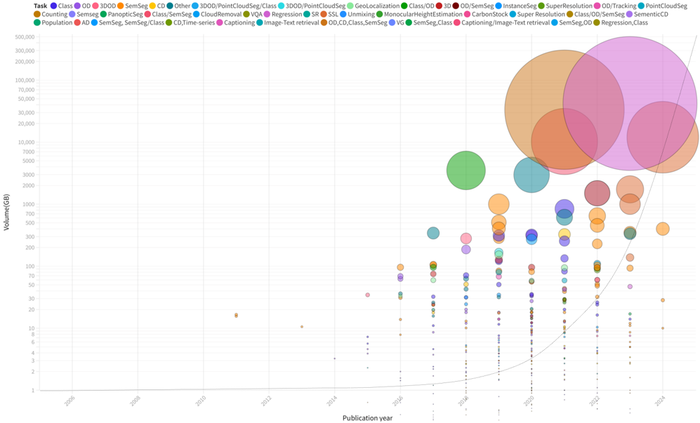
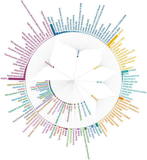
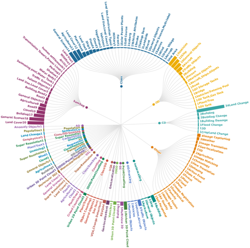
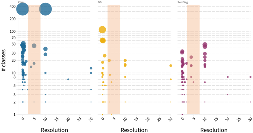
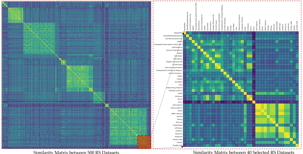
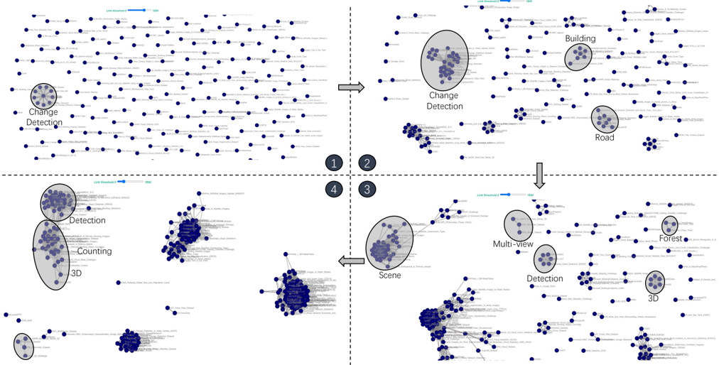
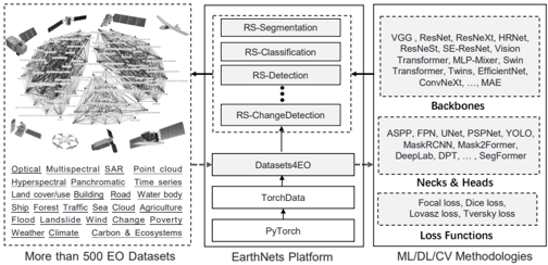
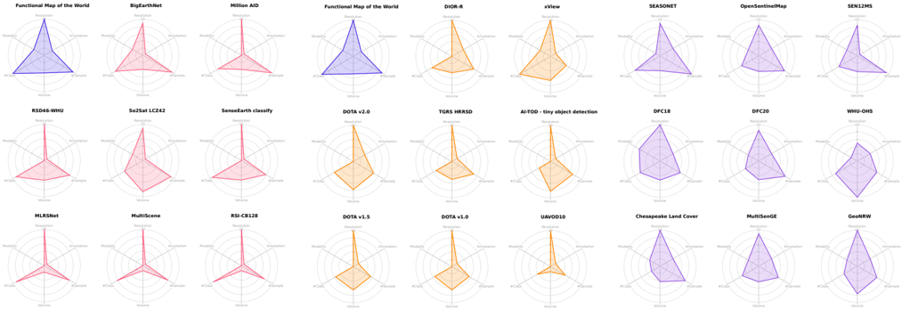
Earth observation (EO), aiming at monitoring the state of planet Earth using remote sensing data, is critical for improving our daily lives and living environment. With a growing number of satellites in orbit, an increasing number of datasets with diverse sensors and research domains are being published to facilitate the research of the remote sensing community. This paper presents a comprehensive review of more than 500 publicly published datasets, including research domains like agriculture, land use and land cover, disaster monitoring, scene understanding, vision-language models, foundation models, climate change, and weather forecasting. We systematically analyze these EO datasets from four aspects: volume, resolution distributions, research domains, and the correlation between datasets. Based on the dataset attributes, we propose to measure, rank, and select datasets to build a new benchmark for model evaluation. Furthermore, a new platform for EO, termed EarthNets, is released to achieve a fair and consistent evaluation of deep learning methods on remote sensing data. EarthNets supports standard dataset libraries and cutting-edge deep learning models to bridge the gap between the remote sensing and machine learning communities. Based on this platform, extensive deep-learning methods are evaluated on the new benchmark. The insightful results are beneficial to future research. The platform and dataset collections are publicly available at https://earthnets.github.io.
Overview
The claims and statistics of this paper haven’t been checked yet.
Run the check — free, no account needed. It reads the open-access text and checks the sources it cites.
Integrity signals
Registry
Cites
Statistics
Figures
Verification
Claims the paper makes
The claims and statistics of this paper haven’t been checked yet.
Run the check — free, no account needed. It reads the open-access text and checks the sources it cites.
Claims other papers make about this one
Each is checked against this paper’s own text: does it say what the citing paper says it does?
The check wasn’t confident either way, so it gives no verdict — never disputed.
In the citing paper
“an incomplete category system will make the model unable to meet the actual mapping requirements (Long et al., 2021, Xiong et al., 2022).”
From Enabling country-scale land cover mapping with meter-resolution satellite imagery (2023) · cites this paper as Xiong et al., 2022
Experimental — accuracy not yet measured
Self-check
Percentages, sums and reported differences re-computed from the paper’s own numbers.
The self-check needs the paper’s full text.
Citations
Cites
Foundation Models for Generalist Geospatial Artificial Intelligence
Jakubik, J., Roy, S., Phillips, C. E., Fraccaro, P., Godwin, D., Zadrozny, B., Szwarcman, D., Gomes, C., Nyirjesy, G., Edwards, B., et al. (2023) · arXiv · Cited by 157 · cited 2×
“Recently, foundation models in RS have demonstrated significant achievements across various EO applications [27].”
BackgroundMethod
Research works printed but not linked: 296
- Xiao Xiang Zhu, Devis Tuia, Lichao Mou, Gui-Song Xia, Liangpei Zhang, Feng Xu, and Friedrich Fraundorfer. Deep learning in remote sensing: A comprehensive review and list of resources. IEEE GRSM, 5(4):8-36, 2017.
- Marek Wójtowicz, Andrzej Wójtowicz, Jan Piekarczyk, et al. Appli- cation of remote sensing methods in agriculture. Communications in Biometry and Crop Science, 11(1):31-50, 2016.
- L Karthikeyan, Ila Chawla, and Ashok K Mishra. A review of remote sensing applications in agriculture for food security: Crop growth and yield, irrigation, and crop losses. Journal of Hydrology, 586:124905, 2020.
- Alex Krizhevsky, Ilya Sutskever, and Geoffrey E Hinton. Im- agenet classification with deep convolutional neural networks. Communications of the ACM, 60(6):84-90, 2017. 1
- Liangpei Zhang, Lefei Zhang, and Bo Du. Deep learning for remote sensing data: A technical tutorial on the state of the art. IEEE GRSM, 4(2):22-40, 2016. 1
- Zhitong Xiong, Yuan Yuan, and Qi Wang. AI-NET: Attention inception neural networks for hyperspectral image classification. In IGARSS, pages 2647-2650. IEEE, 2018. 1
- Giovanni Marchisio, Patrick Helber, Benjamin Bischke, Timothy Davis, Caglar Senaras, Daniele Zanaga, Ruben Van De Kerchove, and Annett Wania. Rapidai4eo: A corpus for higher spatial and temporal rea- soning. In 2021 IEEE International Geoscience and Remote Sensing Symposium IGARSS, pages 1161-1164. IEEE, 2021. 1, 8
- Antje Hecheltjen, Frank Thonfeld, and Gunter Menz. Recent advances in remote sensing change detection-a review. Land use and land cover mapping in Europe, pages 145-178, 2014. 1
- Maryam Rahnemoonfar, Tashnim Chowdhury, Argho Sarkar, Debvrat Varshney, Masoud Yari, and Robin Roberson Murphy. Floodnet: A high resolution aerial imagery dataset for post flood scene understanding. IEEE Access, 9:89644-89654, 2021. 1, 4
- K Bakula, JP Mills, and F Remondino. A review of benchmarking in photogrammetry and remote sensing. ISPRS Archives, 2019. 1
- Michael Schmitt, Seyed Ali Ahmadi, and Ronny Hänsch. There is no data like more data-current status of machine learning datasets in remote sensing. In IGARSS, pages 1206-1209. IEEE, 2021. 1
- Michael Schmitt, Seyed Ali Ahmadi, Yonghao Xu, Gülşen Taşkın, Ujjwal Verma, Francescopaolo Sica, and Ronny Hänsch. There are no data like more data: Datasets for deep learning in earth observation. IEEE Geoscience and Remote Sensing Magazine, 2023. 1
- Yang Long, Gui-Song Xia, Shengyang Li, Wen Yang, Michael Ying Yang, Xiao Xiang Zhu, Liangpei Zhang, and Deren Li. On creating benchmark dataset for aerial image interpretation: Reviews, guidances, and million-aid. IEEE J. Sel. Top. Appl. Earth Obs. Remote Sens., 14:4205-4230, 2021. 1, 2, 4, 11, 12
- Abolfazl Abdollahi, Biswajeet Pradhan, Nagesh Shukla, Subrata Chakraborty, and Abdullah Alamri. Deep learning approaches applied to remote sensing datasets for road extraction: A state-of-the-art review. Remote Sensing, 12(9):1444, 2020. 1, 5
- Ivan Tomljenovic, Bernhard Höfle, Dirk Tiede, and Thomas Blaschke. Building extraction from airborne laser scanning data: An analysis of the state of the art. Remote Sensing, 7(4):3826-3862, 2015. 1
- Michael Schmitt, Pedram Ghamisi, Naoto Yokoya, and Ronny Hänsch. Eod: The ieee grss earth observation database. In IGARSS, pages 5365-5368. IEEE, 2022. 1
- Jia Deng, Wei Dong, Richard Socher, Li-Jia Li, Kai Li, and Li Fei-Fei. Imagenet: A large-scale hierarchical image database. In CVPR, pages 248-255. Ieee, 2009. 2, 16
- Xiao Xiang Zhu, Jingliang Hu, Chunping Qiu, Yilei Shi, Jian Kang, Lichao Mou, Hossein Bagheri, Matthias Häberle, Yuansheng Hua, Rong Huang, et al. So2sat lcz42: A benchmark dataset for global local climate zones classification. arXiv preprint arXiv:1912.12171, 2019. 2, 3, 4, 12 · arXiv
- Gordon Christie, Neil Fendley, James Wilson, and Ryan Mukherjee. Functional map of the world. In CVPR, pages 6172-6180, 2018. 2, 4
- Dominik Koßmann, Viktor Brack, and Thorsten Wilhelm. Seasonet: A seasonal scene classification, segmentation and retrieval dataset for satellite imagery over germany. In IGARSS, pages 243-246. IEEE, 2022. 2, 5, 7, 12, 14, 18
- Adam J Stewart, Caleb Robinson, Isaac A Corley, Anthony Ortiz, Juan M Lavista Ferres, and Arindam Banerjee. Torchgeo: deep learning with geospatial data. arXiv preprint arXiv:2111.08872, 2021. 2, 13 · arXiv
- Otávio AB Penatti, Keiller Nogueira, and Jefersson A Dos Santos. Do deep features generalize from everyday objects to remote sensing and aerial scenes domains? In CVPRW, pages 44-51, 2015. 3, 4
- Marion F Baumgardner, Larry L Biehl, and David A Landgrebe. 220 band aviris hyperspectral image data set: June 12, 1992 indian pine test site 3. Purdue University Research Repository, 10(7):991, 2015. 4
- Rose M Rustowicz, Robin Cheong, Lijing Wang, Stefano Ermon, Marshall Burke, and David Lobell. Semantic segmentation of crop type in africa: A novel dataset and analysis of deep learning methods. In CVPRW, pages 75-82, 2019. 4
- Hannah Kerner, Catherine Nakalembe, and Inbal Becker-Reshef. Field- level crop type classification with k nearest neighbors: a baseline for a new kenya smallholder dataset. arXiv preprint arXiv:2004.03023, 2020. 4 · arXiv
- Gabriel Tseng, Ivan Zvonkov, Catherine Lilian Nakalembe, and Hannah Kerner. Cropharvest: A global dataset for crop-type classification. In NeurIPS Datasets and Benchmarks Track, 2021. 4
- Lukas Kondmann, Aysim Toker, Marc Rußwurm, Andres Camero Un- zueta, Devis Peressuti, Grega Milcinski, Nicolas Longépé, Pierre- Philippe Mathieu, Timothy Davis, Giovanni Marchisio, et al. DENETHOR: The DynamicEarthNET dataset for Harmonized, inter- Operable, analysis-Ready, daily crop monitoring from space. In NeurIPS Datasets and Benchmarks Track, 2021. 3, 4
- Etienne Lord Amanda A. Boatswain Jacques, Abdoulaye Baniré Diallo. Towards the creation of a canadian land-use dataset for agricultural land classification. In Canadian Symposium on Remote Sensing, 2021. 3, 4
- George Choumos, Alkiviadis Koukos, Vasileios Sitokonstantinou, and Charalampos Kontoes. Towards space-to-ground data availability for agriculture monitoring. In IVMSP, pages 1-5, 2022. 4
- Dimitris Sykas, Ioannis Papoutsis, and Dimitrios Zografakis. Sen4agrinet: A harmonized multi-country, multi-temporal benchmark dataset for agricultural earth observation machine learning applications. In IGARSS, pages 5830-5833. IEEE, 2021. 3, 4, 9
- Xian Sun, Yixuan Lv, Zhirui Wang, and Kun Fu. Scan: Scattering characteristics analysis network for few-shot aircraft classification in high-resolution sar images. IEEE TGRS, 60:1-17, 2022. 3, 4, 5
- YU Wenqi, CHENG Gong, WANG Meijun, YAO Yanqing, XIE Xingx- ing, YAO Xiwen, and HAN Junwei. Mar20: A benchmark for military aircraft recognition in remote sensing images. National Remote Sensing Bulletin, 27(12):2688-2696, 2024. 4, 6
- M Joseph Hughes and Daniel J Hayes. Automated detection of cloud and cloud shadow in single-date landsat imagery using neural networks and spatial post-processing. Remote Sensing, 6(6):4907-4926, 2014. 4
- A. H. Nielsen, A. Iosifidis, and H. Karstoft. Cloudcast: A satellite- based dataset and baseline for forecasting clouds. IEEE J. Sel. Top. Appl. Earth Obs. Remote Sens., 14:3485-3494, 2021. 4
- L. Mou, Y. Hua, P. Jin, and X. X. Zhu. ERA: A dataset and deep learning benchmark for event recognition in aerial videos. IEEE GRSM, in press. 4
- Quoc Dung Cao and Youngjun Choe. Building damage annotation on post-hurricane satellite imagery based on convolutional neural networks. Natural Hazards, 103(3):3357-3376, 2020. 3, 4
- Derrick Bonafilia, Beth Tellman, Tyler Anderson, and Erica Issenberg. Sen1floods11: A georeferenced dataset to train and test deep learning flood algorithms for sentinel-1. In CVPRW, pages 210-211, 2020. 3, 4
- Georgios I Drakonakis, Grigorios Tsagkatakis, Konstantina Fotiadou, and Panagiotis Tsakalides. Ombrianet-supervised flood mapping via convolutional neural networks using multitemporal sentinel-1 and sentinel-2 data fusion. IEEE J. Sel. Top. Appl. Earth Obs. Remote Sens., 15:2341-2356, 2022. 4
- David Noever and Samantha E Miller Noever. Overhead mnist: A benchmark satellite dataset. arXiv preprint arXiv:2102.04266, 2021. 4 · arXiv
- Yi Yang and Shawn Newsam. Bag-of-visual-words and spatial exten- sions for land-use classification. In ACM SIGSPATIAL, pages 270- 279, 2010. 4
- Qin Zou, Lihao Ni, Tong Zhang, and Qian Wang. Deep learning based feature selection for remote sensing scene classification. IEEE Geosci. Remote Sens. Lett., 12(11):2321-2325, 2015. 4
- Gong Cheng, Junwei Han, and Xiaoqiang Lu. Remote sensing image scene classification: Benchmark and state of the art. Proceedings of the IEEE, 105(10):1865-1883, 2017. 3, 4
- Lijun Zhao, Ping Tang, and Lianzhi Huo. Feature significance- based multibag-of-visual-words model for remote sensing image scene classification. Journal of Applied Remote Sensing, 10(3):035004, 2016.
- Gui-Song Xia, Jingwen Hu, Fan Hu, Baoguang Shi, Xiang Bai, Yanfei Zhong, Liangpei Zhang, and Xiaoqiang Lu. Aid: A benchmark data set for performance evaluation of aerial scene classification. IEEE TGRS, 55(7):3965-3981, 2017. 4
- Zhifeng Xiao, Yang Long, Deren Li, Chunshan Wei, Gefu Tang, and Junyi Liu. High-resolution remote sensing image retrieval based on cnns from a dimensional perspective. Remote Sensing, 9(7):725, 2017. 3, 4, 12
- Qi Wang, Shaoteng Liu, Jocelyn Chanussot, and Xuelong Li. Scene classification with recurrent attention of vhr remote sensing images. IEEE TGRS, 57(2):1155-1167, 2018. 4
- Haifeng Li, Hao Jiang, Xin Gu, Jian Peng, Wenbo Li, Liang Hong, and Chao Tao. Clrs: Continual learning benchmark for remote sensing image scene classification. Sensors, 20(4):1226, 2020. 4
- Zhuang Zhou, Shengyang Li, Wei Wu, Weilong Guo, Xuan Li, Guisong Xia, and Zifei Zhao. Nasc-tg2: Natural scene classification with tiangong-2 remotely sensed imagery. IEEE J. Sel. Top. Appl. Earth Obs. Remote Sens., 14:3228-3242, 2021. 4
- Yuansheng Hua, Lichao Mou, Pu Jin, and Xiao Xiang Zhu. Multiscene: A large-scale dataset and benchmark for multiscene recognition in single aerial images. IEEE TGRS, 60:1-13, 2021. 4
- Nikolaos Ioannis Bountos, Ioannis Papoutsis, Dimitrios Michail, An- dreas Karavias, Panagiotis Elias, and Isaak Parcharidis. Hephaestus: A large scale multitask dataset towards insar understanding. In CVPR, pages 1453-1462, 2022. 4
- Kazuki Uehara, Hidenori Sakanashi, Hirokazu Nosato, Masahiro Mu- rakawa, Hiroki Miyamoto, and Ryosuke Nakamura. Object detection of satellite images using multi-channel higher-order local autocorrelation. In IEEE SMC, pages 1339-1344. IEEE, 2017. 4
- Saikat Basu, Sangram Ganguly, Supratik Mukhopadhyay, Robert DiB- iano, Manohar Karki, and Ramakrishna Nemani. Deepsat: a learning framework for satellite imagery. In ACM SIGSPATIAL, pages 1-10, 2015. 4
- Reza Bahmanyar, Daniela Espinoza-Molina, and Mihai Datcu. Mul- tisensor earth observation image classification based on a multimodal latent dirichlet allocation model. IEEE Geosci. Remote Sens. Lett., 15(3):459-463, 2018. 3, 4
- Gencer Sumbul, Marcela Charfuelan, Begum Demir, and Volker Markl. Bigearthnet: A large-scale benchmark archive for remote sensing image understanding. In IGARSS, pages 5901-5904. IEEE, 2019. 3, 4, 12, 13, 21
- Yanfei Zhong, Qiqi Zhu, and Liangpei Zhang. Scene classification based on the multifeature fusion probabilistic topic model for high spatial resolution remote sensing imagery. IEEE TGRS, 53(11):6207- 6222, 2015. 3, 4
- Haifeng Li, Xin Dou, Chao Tao, Zhixiang Wu, Jie Chen, Jian Peng, Min Deng, and Ling Zhao. Rsi-cb: A large-scale remote sensing image classification benchmark using crowdsourced data. Sensors, 20(6):1594, 2020. 3, 4
- Rémi Ratajczak, Carlos F Crispim-Junior, Élodie Faure, Béatrice Fervers, and Laure Tougne. Automatic Land Cover Reconstruction From Historical Aerial Images: An Evaluation of Features Extraction and Classification Algorithms. IEEE Trans. Image Process., January 2019. 4
- Gabriel Machado, Edemir Ferreira, Keiller Nogueira, Hugo Oliveira, Matheus Brito, Pedro Henrique Targino Gama, and Jefersson Alex dos Santos. Airound and cv-brct: Novel multiview datasets for scene classification. IEEE J. Sel. Top. Appl. Earth Obs. Remote Sens., 14:488-503, 2020. 3, 4
- Patrick Helber, Benjamin Bischke, Andreas Dengel, and Damian Borth. Eurosat: A novel dataset and deep learning benchmark for land use and land cover classification. IEEE J. Sel. Top. Appl. Earth Obs. Remote Sens., 12(7):2217-2226, 2019. 3, 4
- Shunping Ji, Dawen Yu, Chaoyong Shen, Weile Li, and Qiang Xu. Landslide detection from an open satellite imagery and digital elevation model dataset using attention boosted convolutional neural networks. Landslides, 17(6):1337-1352, 2020. 4
- Sara Beery, Guanhang Wu, Trevor Edwards, Filip Pavetic, Bo Ma- jewski, Shreyasee Mukherjee, Stanley Chan, John Morgan, Vivek Rathod, and Jonathan Huang. The auto arborist dataset: A large-scale benchmark for multiview urban forest monitoring under domain shift. In CVPR, pages 21294-21307, 2022. 4
- Steve Ahlswede, Christian Schulz, Christiano Gava, Patrick Helber, Benjamin Bischke, Michael Förster, Florencia Arias, Jörn Hees, Begüm Demir, and Birgit Kleinschmit. Treesatai benchmark archive: A multi- sensor, multi-label dataset for tree species classification in remote sensing. Earth System Science Data Discussions, pages 1-22, 2022. 4
- Gallego Antonio-Javier, Pertusa Antonio, and Gil Pablo. Automatic ship classification from optical aerial images with convolutional neural networks. Remote Sensing, 10(4), 2018. 3, 4
- Yanghua Di, Zhiguo Jiang, Haopeng Zhang, and Gang Meng. A public dataset for ship classification in remote sensing images. In SPIE, volume 11155, pages 515-521, 2019. 3, 4
- Igor G Rizaev and Alin Achim. Synthwakesar: A synthetic sar dataset for deep learning classification of ships at sea. Remote Sensing, 14(16):3999, 2022. 3, 4
- Rui Ba, Chen Chen, Jing Yuan, Weiguo Song, and Siuming Lo. Smokenet: Satellite smoke scene detection using convolutional neural network with spatial and channel-wise attention. Remote Sensing, 11(14):1702, 2019. 3, 4
- Nevrez Imamoglu, Motoki Kimura, Hiroki Miyamoto, Aito Fujita, and Ryosuke Nakamura. Solar power plant detection on multi-spectral satellite imagery using weakly-supervised cnn with feedback features and m-pcnn fusion. arXiv preprint arXiv:1704.06410, 2017. 3, 4 · arXiv
- Elijah Cole, Benjamin Deneu, Titouan Lorieul, Maximilien Serva- jean, Christophe Botella, Dan Morris, Nebojsa Jojic, Pierre Bonnet, and Alexis Joly. The geolifeclef 2020 dataset. arXiv preprint arXiv:2004.04192, 2020. 4 · arXiv
- Edemir Ferreira, Matheus Brito, Remis Balaniuk, Mário S Alvim, and Jefersson A dos Santos. Brazildam: A benchmark dataset for tailings dam detection. In LAGIRS, pages 339-344. IEEE, 2020. 4
- Keiller Nogueira, Jefersson A Dos Santos, Tamires Fornazari, Thiago Sanna Freire Silva, Leonor Patricia Morellato, and Ricardo da S Torres. Towards vegetation species discrimination by using data-driven descriptors. In PRRS, pages 1-6. Ieee, 2016. 4
- Burak Uzkent, Aneesh Rangnekar, and Matthew J Hoffman. Tracking in aerial hyperspectral videos using deep kernelized correlation filters. arXiv preprint arXiv:1711.07235, 2017. 4 · arXiv
- Eran Dahan, Tzvi Diskin, Amit Amram, Amit Moryossef, and Omer Koren. Cofga: A dataset for fine grained classification of objects from aerial imagery. arXiv preprint arXiv:2105.12786, 2021. 4 · arXiv
- Shaoqing Ren, Kaiming He, Ross Girshick, and Jian Sun. Faster r- cnn: Towards real-time object detection with region proposal networks. NeurIPS, 28, 2015. 5, 14
- Wei Liu, Dragomir Anguelov, Dumitru Erhan, Christian Szegedy, Scott Reed, Cheng-Yang Fu, and Alexander C Berg. SSD: Single shot multibox detector. In ECCV, pages 21-37. Springer, 2016. 5
- Joseph Redmon, Santosh Divvala, Ross Girshick, and Ali Farhadi. You only look once: Unified, real-time object detection. In CVPR, pages 779-788, 2016. 5, 14, 16
- Nicolas Carion, Francisco Massa, Gabriel Synnaeve, Nicolas Usunier, Alexander Kirillov, and Sergey Zagoruyko. End-to-end object detection with transformers. In ECCV, pages 213-229. Springer, 2020. 5
- Nicholas Weir, David Lindenbaum, Alexei Bastidas, Adam Van Etten, Sean McPherson, Jacob Shermeyer, Varun Kumar, and Hanlin Tang. Spacenet mvoi: A multi-view overhead imagery dataset. In ICCV, pages 992-1001, 2019. 5, 6
- Lanqing Huang, Bin Liu, Boying Li, Weiwei Guo, Wenhao Yu, Zenghui Zhang, and Wenxian Yu. Opensarship: A dataset dedicated to sentinel- 1 ship interpretation. IEEE J. Sel. Top. Appl. Earth Obs. Remote Sens., 11(1):195-208, 2017. 5, 6
- Jianwei Li, Changwen Qu, and Jiaqi Shao. Ship detection in sar images based on an improved faster r-cnn. In BIGSARDATA, pages 1-6. IEEE, 2017. 5, 6 [123] Airbus. Airbus ship detection challenge, 2018. 5, 6
- Geremy Heitz and Daphne Koller. Learning spatial context: Using stuff to find things. In ECCV, pages 30-43. Springer, 2008. 5, 6
- Sebastien Razakarivony and Frederic Jurie. Vehicle detection in aerial imagery: A small target detection benchmark. Journal of Visual Communication and Image Representation, 34:187-203, 2016. 5, 6
- T Nathan Mundhenk, Goran Konjevod, Wesam A Sakla, and Kofi Boakye. A large contextual dataset for classification, detection and counting of cars with deep learning. In ECCV, pages 785-800. Springer, 2016. 5, 6
- Yang Long, Yiping Gong, Zhifeng Xiao, and Qing Liu. Accurate object localization in remote sensing images based on convolutional neural networks. IEEE TGRS, 55(5):2486-2498, 2017. 5, 6
- Yuanlin Zhang, Yuan Yuan, Yachuang Feng, and Xiaoqiang Lu. Hierar- chical and robust convolutional neural network for very high-resolution remote sensing object detection. IEEE TGRS, 57(8):5535-5548, 2019. 5, 6, 12 [133] xView. xview 2018 object detection challenge, 2019. 5, 6, 12
- Gordon Christie, Neil Fendley, James Wilson, and Ryan Mukherjee. Functional map of the world. In CVPR, 2018. 5, 6, 9, 12, 13, 20
- Gui-Song Xia, Xiang Bai, Jian Ding, Zhen Zhu, Serge Belongie, Jiebo Luo, Mihai Datcu, Marcello Pelillo, and Liangpei Zhang. Dota: A large-scale dataset for object detection in aerial images. In CVPR, June 2018. 5, 6
- Jinwang Wang, Wen Yang, Haowen Guo, Ruixiang Zhang, and Gui- Song Xia. Tiny object detection in aerial images. pages 3791-3798, 2021. 5, 6
- Gong Cheng, Xiang Yuan, Xiwen Yao, Kebing Yan, Qinghua Zeng, and Junwei Han. Towards large-scale small object detection: Survey and benchmarks. arXiv preprint arXiv:2207.14096, 2022. 5, 6 [143] Hydice image of washington dc mall, 2022. 5 · arXiv
- Adrian Boguszewski, Dominik Batorski, Natalia Ziemba-Jankowska, Tomasz Dziedzic, and Anna Zambrzycka. Landcover. ai: Dataset for automatic mapping of buildings, woodlands, water and roads from aerial imagery. In CVPR, pages 1102-1110, 2021. 5, 7
- Michael Schmitt, Lloyd Haydn Hughes, Chunping Qiu, and Xiao Xiang Zhu. Sen12ms-a curated dataset of georeferenced multi-spectral sentinel-1/2 imagery for deep learning and data fusion. arXiv preprint arXiv:1906.07789, 2019. 5, 7, 12 [147] Semantic segmentation of aerial imagery, 2019. 5, 7 · arXiv
- Zhirui Wang, Xuan Zeng, Zhiyuan Yan, Jian Kang, and Xian Sun. Air- polsar-seg: A large-scale data set for terrain segmentation in complex- scene polsar images. IEEE J. Sel. Top. Appl. Earth Obs. Remote Sens., 15:3830-3841, 2022. 5, 6, 7
- Vivien Sainte Fare Garnot and Loic Landrieu. Panoptic segmentation of satellite image time series with convolutional temporal attention networks. ICCV, 2021. 5, 6
- Peng Zhang, Hao Xu, Tian Tian, Peng Gao, Linfeng Li, Tianming Zhao, Nan Zhang, and Jinwen Tian. Sefepnet: Scale expansion and feature enhancement pyramid network for sar aircraft detection with small sample dataset. IEEE J. Sel. Top. Appl. Earth Obs. Remote Sens., 15:3365-3375, 2022. 6
- Shunping Ji, Shiqing Wei, and Meng Lu. Fully convolutional networks for multisource building extraction from an open aerial and satellite imagery data set. IEEE TGRS, 57(1):574-586, 2018. 6, 8
- Jinwang Wang, Lingxuan Meng, Weijia Li, Wen Yang, Lei Yu, and Gui-Song Xia. Learning to extract building footprints from off-nadir aerial images. IEEE Trans. Pattern Anal. Mach. Intell., pages 1-1, 2022. 6
- Xiaoyu Zhu, Junwei Liang, and Alexander Hauptmann. Msnet: A multilevel instance segmentation network for natural disaster damage assessment in aerial videos. In Proceedings of the IEEE/CVF winter conference on applications of computer vision, pages 2023-2032, 2021. 6
- Ding Jian, Xue Nan, Long Yang, Xia Gui-Song, and Lu Qikai. Learning roi transformer for detecting oriented objects in aerial images. In CVPR, June 2019. 6
- Jian Ding, Nan Xue, Gui-Song Xia, Xiang Bai, Wen Yang, Michael Yang, Serge Belongie, Jiebo Luo, Mihai Datcu, Marcello Pelillo, and Liangpei Zhang. Object detection in aerial images: A large-scale benchmark and challenges. IEEE Trans. Pattern Anal. Mach. Intell., pages 1-1, 2021. 6, 12
- Syed Waqas Zamir, Aditya Arora, Akshita Gupta, Salman Khan, Guolei Sun, Fahad Shahbaz Khan, Fan Zhu, Ling Shao, Gui-Song Xia, and Xiang Bai. isaid: A large-scale dataset for instance segmentation in aerial images. In CVPRW, pages 28-37, 2019. 6
- Elizabeth Bondi, Raghav Jain, Palash Aggrawal, Saket Anand, Robert Hannaford, Ashish Kapoor, Jim Piavis, Shital Shah, Lucas Joppa, Bistra Dilkina, et al. Birdsai: A dataset for detection and tracking in aerial thermal infrared videos. In WACV, pages 1747-1756, 2020. 6
- Guangshuai Gao, Qingjie Liu, and Yunhong Wang. Counting from sky: A large-scale data set for remote sensing object counting and a benchmark method. IEEE TGRS, 59(5):3642-3655, 2020. 6, 17
- Nikolaos Ioannis Bountos, Ioannis Papoutsis, Dimitrios Michail, An- dreas Karavias, Panagiotis Elias, and Isaak Parcharidis. Hephaestus: A large scale multitask dataset towards insar understanding. In CVPRW, pages 1453-1462, June 2022. 6
- A Robicquet, A Sadeghian, A Alahi, and S Savarese. Learning social etiquette: Human trajectory prediction in crowded scenes. In ECCV, volume 2, 2020. 6
- Leon Amadeus Varga, Benjamin Kiefer, Martin Messmer, and Andreas Zell. Seadronessee: A maritime benchmark for detecting humans in open water. In WACV, pages 2260-2270, 2022. 6
- Jan G ąsienica-Józkowy, Mateusz Knapik, and Boguslaw Cyganek. An ensemble deep learning method with optimized weights for drone- based water rescue and surveillance. Integrated Computer-Aided Engineering, pages 1-15, 01 2021. 6
- Zikun Liu, Liu Yuan, Lubin Weng, and Yiping Yang. A high resolution optical satellite image dataset for ship recognition and some new baselines. In ICPRAM, volume 2, pages 324-331. SciTePress, 2017. 6
- Yuanyuan Wang, Chao Wang, Hong Zhang, Yingbo Dong, and Sisi Wei. A sar dataset of ship detection for deep learning under complex backgrounds. Remote Sensing, 11(7), 2019. 6
- SUN Xian, WANG Zhirui, SUN Yuanrui, DIAO Wenhui, ZHANG Yue, and FU Kun. Air-sarship-1.0: High-resolution sar ship detection dataset. Journal of Radars, 8(6):852-863, 2019. 6
- Fuduo Xue, Weiqi Jin, Su Qiu, and Jie Yang. Rethinking automatic ship wake detection: State-of-the-art cnn-based wake detection via optical images. IEEE TGRS, 60:1-22, 2021. 6 [184
- Ilker Bozcan and Erdal Kayacan. Au-air: A multi-modal unmanned aerial vehicle dataset for low altitude traffic surveillance. In ICRA, pages 8504-8510. IEEE, 2020. 6
- Robert Krajewski, Julian Bock, Laurent Kloeker, and Lutz Eckstein. The highd dataset: A drone dataset of naturalistic vehicle trajectories on german highways for validation of highly automated driving systems. In ITSC, pages 2118-2125, 2018. 6
- Wei Zhan, Liting Sun, Di Wang, Haojie Shi, Aubrey Clausse, Max- imilian Naumann, Julius Kümmerle, Hendrik Königshof, Christoph Stiller, Arnaud de La Fortelle, and Masayoshi Tomizuka. INTER- ACTION Dataset: An INTERnational, Adversarial and Cooperative moTION Dataset in Interactive Driving Scenarios with Semantic Maps. arXiv:1910.03088 [cs, eess], 2019. 6 · arXiv
- Julian Bock, Robert Krajewski, Tobias Moers, Steffen Runde, Lennart Vater, and Lutz Eckstein. The ind dataset: A drone dataset of naturalistic road user trajectories at german intersections. In IV, pages 1929-1934, 2020. 6
- Robert Krajewski, Tobias Moers, Julian Bock, Lennart Vater, and Lutz Eckstein. The round dataset: A drone dataset of road user trajectories at roundabouts in germany. In ITSC, pages 1-6, 2020. 6
- Haigang Zhu, Xiaogang Chen, Weiqun Dai, Kun Fu, Qixiang Ye, and Jianbin Jiao. Orientation robust object detection in aerial images using deep convolutional neural network. In ICIP, pages 3735-3739. IEEE, 2015. 6
- Paulo RL De Almeida, Luiz S Oliveira, Alceu S Britto Jr, Eunelson J Silva Jr, and Alessandro L Koerich. Pklot-a robust dataset for parking lot classification. Expert Systems with Applications, 42(11):4937- 4949, 2015. 6
- Meng-Ru Hsieh, Yen-Liang Lin, and Winston H Hsu. Drone-based object counting by spatially regularized regional proposal network. In ICCV, pages 4145-4153, 2017. 6
- Pengfei Zhu, Longyin Wen, Dawei Du, Xiao Bian, Heng Fan, Qinghua Hu, and Haibin Ling. Detection and tracking meet drones challenge. IEEE Trans. Pattern Anal. Mach. Intell., pages 1-1, 2021. 6, 17
- M. Haroon, M. Shahzad, and M. M. Fraz. Multi-sized object detection using spaceborne optical imagery. IEEE J. Sel. Top. Appl. Earth Obs. Remote Sens., 13:3032-3046, 2020. 6
- Pengfei Zhu, Longyin Wen, Dawei Du, Xiao Bian, Heng Fan, Qinghua Hu, and Haibin Ling. Detection and tracking meet drones challenge. IEEE Trans. Pattern Anal. Mach. Intell., 2021. 6
- Seyed Majid Azimi, Reza Bahmanyar, Corentin Henry, and Franz Kurz. Eagle: Large-scale vehicle detection dataset in real-world scenarios using aerial imagery. In ICPR, pages 6920-6927, 2021. 6
- Murari Mandal, Lav Kush Kumar, and Santosh Kumar Vipparthi. Mor- uav: A benchmark dataset and baselines for moving object recognition in uav videos. In ACM Multimedia, pages 2626-2635, 2020. 6
- Yiming Sun, Bing Cao, Pengfei Zhu, and Qinghua Hu. Drone-based rgb-infrared cross-modality vehicle detection via uncertainty-aware learning. IEEE TCSVT, pages 1-1, 2022. 6
- Immanuel Weber, Jens Bongartz, and Ribana Roscher. Artifive- potsdam: A benchmark for learning with artificial objects for improved aerial vehicle detection. In IGARSS, pages 1214-1217. IEEE, 2021. 6
- Yahui Liu, Jian Yao, Xiaohu Lu, Menghan Xia, Xingbo Wang, and Yuan Liu. Roadnet: Learning to comprehensively analyze road net- works in complex urban scenes from high-resolution remotely sensed images. IEEE TGRS, 57(4):2043-2056, 2019. 5, 7
- Emmanuel Maggiori, Yuliya Tarabalka, Guillaume Charpiat, and Pierre Alliez. Can semantic labeling methods generalize to any city? the inria aerial image labeling benchmark. In IGARSS, pages 3226-3229. IEEE, 2017. 5, 7
- Gellért Máttyus, Shenlong Wang, Sanja Fidler, and Raquel Urtasun. Hd maps: Fine-grained road segmentation by parsing ground and aerial images. In CVPR, pages 3611-3619, 2016. 5, 7
- Gellert Mattyus, Shenlong Wang, Sanja Fidler, and Raquel Urtasun. Enhancing road maps by parsing aerial images around the world. In ICCV, pages 1689-1697, 2015. 5, 7
- Favyen Bastani, Songtao He, Sofiane Abbar, Mohammad Alizadeh, Hari Balakrishnan, Sanjay Chawla, Sam Madden, and David DeWitt. Roadtracer: Automatic extraction of road networks from aerial images. In CVPR, pages 4720-4728, 2018. 5, 7 [211] Microsoft roaddetections, 2020. 5, 7
- S. Mohajerani and P. Saeedi. Cloud-net: An end-to-end cloud detection algorithm for landsat 8 imagery. In IGARSS, pages 1029-1032, July 2019. 5, 7
- Zhiwei Li, Huanfeng Shen, Qing Cheng, Yuhao Liu, Shucheng You, and Zongyi He. Deep learning based cloud detection for remote sensing images by the fusion of multi-scale convolutional features. arXiv preprint arXiv:1810.05801, 2018. 5, 7 · arXiv
- Jun Li, Zhaocong Wu, Zhongwen Hu, Canliang Jian, Shaojie Luo, Lichao Mou, Xiao Xiang Zhu, and Matthieu Molinier. A lightweight deep learning-based cloud detection method for sentinel-2a imagery fusing multiscale spectral and spatial features. IEEE TGRS, 60:1-19, 2021. 5, 7
- Julia A Barsi, Kenton Lee, Geir Kvaran, Brian L Markham, and Jeffrey A Pedelty. The spectral response of the landsat-8 operational land imager. Remote sensing, 6(10):10232-10251, 2014. 5, 7
- Shunping Ji, Zhili Zhang, Chi Zhang, Shiqing Wei, Meng Lu, and Yulin Duan. Learning discriminative spatiotemporal features for precise crop classification from multi-temporal satellite images. Int. J. Remote Sens., 41(8):3162-3174, 2020. 5, 7
- Giulio Weikmann, Claudia Paris, and Lorenzo Bruzzone. Time- sen2crop: A million labeled samples dataset of sentinel 2 image time series for crop-type classification. IEEE J. Sel. Top. Appl. Earth Obs. Remote Sens., 14:4699-4708, 2021. 5, 7
- Mang Tik Chiu, Xingqian Xu, Yunchao Wei, Zilong Huang, Alexan- der G Schwing, Robert Brunner, Hrant Khachatrian, Hovnatan Kara- petyan, Ivan Dozier, Greg Rose, et al. Agriculture-vision: A large aerial image database for agricultural pattern analysis. In CVPR, pages 2828- 2838, 2020. 5, 7
- Yi-Ran Wang and Xiao-Ming Li. Arctic sea ice cover data from spaceborne synthetic aperture radar by deep learning. Earth System Science Data, 13(6):2723-2742, 2021. 7
- Adam Van Etten, Dave Lindenbaum, and Todd M Bacastow. Spacenet: A remote sensing dataset and challenge series. arXiv preprint arXiv:1807.01232, 2018. 7 · arXiv
- Jacob Shermeyer, Daniel Hogan, Jason Brown, Adam Van Etten, Nicholas Weir, Fabio Pacifici, Ronny Hansch, Alexei Bastidas, Scott Soenen, Todd Bacastow, et al. Spacenet 6: Multi-sensor all weather mapping dataset. In CVPRW, pages 196-197, 2020. 7
- Adam Van Etten, Daniel Hogan, Jesus Martinez Manso, Jacob Sher- meyer, Nicholas Weir, and Ryan Lewis. The multi-temporal urban development spacenet dataset. In CVPR, pages 6398-6407, 2021. 7
- Fanjie Kong, Bohao Huang, Kyle Bradbury, and Jordan Malof. The synthinel-1 dataset: A collection of high resolution synthetic overhead imagery for building segmentation. In WACV, pages 1814-1823, 2020. 7
- Volodymyr Mnih. Machine Learning for Aerial Image Labeling. PhD thesis, University of Toronto, 2013. 7
- Pascal Kaiser, Jan Dirk Wegner, Aurélien Lucchi, Martin Jaggi, Thomas Hofmann, and Konrad Schindler. Learning aerial image segmentation from online maps. IEEE TGRS, 55(11):6054-6068, 2017. 7
- Louis Baetens, Camille Desjardins, and Olivier Hagolle. Validation of copernicus sentinel-2 cloud masks obtained from maja, sen2cor, and fmask processors using reference cloud masks generated with a supervised active learning procedure. Remote Sensing, 11(4):433, 2019. 7
- Shunping Ji, Peiyu Dai, Meng Lu, and Yongjun Zhang. Simultaneous cloud detection and removal from bitemporal remote sensing images using cascade convolutional neural networks. IEEE TGRS, 59(1):732- 748, 2020. 7, 16
- Q. He, X. Sun, Z. Yan, and K. Fu. Dabnet: Deformable contextual and boundary-weighted network for cloud detection in remote sensing images. IEEE TGRS, pages 1-16, 2021. 7
- Zhenfeng Shao, Ke Yang, and Weixun Zhou. Performance evaluation of single-label and multi-label remote sensing image retrieval using a dense labeling dataset. Remote Sensing, 10(6):964, 2018. 7
- Jiangye Yuan, Shaun S Gleason, and Anil M Cheriyadat. Systematic benchmarking of aerial image segmentation. IEEE Geosci. Remote Sens. Lett., 10(6):1527-1531, 2013. 7
- Gabriele Moser, Devis Tuia, and Michal Shimoni. 2015 ieee grss data fusion contest: Extremely high resolution lidar and optical data [technical committees]. IEEE GRSM, 3(1):40-41, 2015. 7
- Michele Volpi and Vittorio Ferrari. Semantic segmentation of urban scenes by learning local class interactions. In CVPRW, pages 1-9, 2015. 7
- Mi Zhang, Xiangyun Hu, Like Zhao, Ye Lv, Min Luo, and Shiyan Pang. Learning dual multi-scale manifold ranking for semantic segmentation of high-resolution images. Remote Sensing, 9(5):500, 2017. 7
- Maria Scanlon. Semantic Annotation of Aerial Images using Deep Learning, Transfer Learning, and Synthetic Training Data. PhD thesis, 09 2018. 7
- Ishan Nigam, Chen Huang, and Deva Ramanan. Ensemble knowledge transfer for semantic segmentation. In WACV, pages 1499-1508. IEEE, 2018. 7
- Yu Chen, Yao Wang, Peng Lu, Yisong Chen, and Guoping Wang. Large-scale structure from motion with semantic constraints of aerial images. In PRCV, pages 347-359. Springer, 2018. 7
- Michael Fonder and Marc Van Droogenbroeck. Mid-air: A multi-modal dataset for extremely low altitude drone flights. In CVPRW, pages 0-0, 2019. 7
- Aneesh Rangnekar, Nilay Mokashi, Emmett J Ientilucci, Christopher Kanan, and Matthew J Hoffman. Aerorit: A new scene for hyperspectral image analysis. IEEE TGRS, 58(11):8116-8124, 2020. 7
- Ribana Roscher, Michele Volpi, Clément Mallet, Lukas Drees, and Jan Dirk Wegner. Semcity toulouse: A benchmark for building instance segmentation in satellite images. In ISPRS Annals, volume 5, pages 109-116, 2020. 7
- Ilke Demir, Krzysztof Koperski, David Lindenbaum, Guan Pang, Jing Huang, Saikat Basu, Forest Hughes, Devis Tuia, and Ramesh Raskar. Deepglobe 2018: A challenge to parse the earth through satellite images. In CVPRW, pages 172-181, 2018. 7
- Bertrand Le Saux, Naoto Yokoya, Ronny Hänsch, and Myron Brown. 2019 ieee grss data fusion contest: large-scale semantic 3d reconstruc- tion. IEEE GRSM, 7(4):33-36, 2019. 7
- Caleb Robinson, Le Hou, Kolya Malkin, Bistra Dilkina, and Nebojsa Jojic. Large scale high-resolution land cover mapping with multi- resolution data. In CVPR, pages 12726-12735, 2019. 7
- Naoto Yokoya, Pedram Ghamisi, Ronny Hänsch, and Michael Schmitt. 2020 IEEE GRSS data fusion contest: Global land cover mapping with weak supervision [technical committees]. IEEE GRSM, 8(1):154-157, 2020. 7
- Yue Xu, Jianya Gong, Xin Huang, Xiangyun Hu, Jiayi Li, Qiang Li, and Min Peng. Luojia-hssr: A high spatial-spectral resolution remote sensing dataset for land-cover classification with a new 3d- hrnet. Geo-Spatial Information Science, 26(3):289-301, 2023. 7
- Junjue Wang, Zhuo Zheng, Ailong Ma, Xiaoyan Lu, and Yanfei Zhong. Loveda: A remote sensing land-cover dataset for domain adaptive semantic segmentation. arXiv preprint arXiv:2110.08733, 2021. 7 · arXiv
- Javiera Castillo-Navarro, Bertrand Le Saux, Alexandre Boulch, Nicolas Audebert, and Sébastien Lefèvre. Semi-supervised semantic segmen- tation in earth observation: The minifrance suite, dataset analysis and multi-task network study. Machine Learning, pages 1-36, 2021. 7
- Gerald Baier, Antonin Deschemps, Michael Schmitt, and Naoto Yokoya. Synthesizing optical and sar imagery from land cover maps and auxiliary raster data. IEEE TGRS, 60:1-12, 2021. 7, 12, 14, 18
- Rohaifa Khaldi, Domingo Alcaraz-Segura, Emilio Guirado, Yassir Benhammou, Abdellatif El Afia, Francisco Herrera, and Siham Tabik. Timespec4lulc: a global multispectral time series database for training lulc mapping models with machine learning. Earth System Science Data, 14(3):1377-1411, 2022. 7
- Xin-Yi Tong, Gui-Song Xia, and Xiao Xiang Zhu. Enabling country- scale land cover mapping with meter-resolution satellite imagery. arXiv preprint arXiv:2209.00727, 2022. 7, 12 · arXiv
- Noah Johnson, Wayne Treible, and Daniel Crispell. Opensentinelmap: A large-scale land use dataset using openstreetmap and sentinel-2 imagery. In CVPR, pages 1333-1341, 2022. 7, 12
- Bertrand Le Saux, Naoto Yokoya, Ronny Hänsch, and Saurabh Prasad. 2018 ieee grss data fusion contest: Multimodal land use classification [technical committees]. IEEE GRSM, 6(1):52-54, 2018. 7
- Romain Wenger, A Puissant, J Weber, L Idoumghar, and G Forestier. Multisenge: a multimodal and multitemporal benchmark dataset for land use/land cover remote sensing applications. ISPRS Annals, pages 635-640, 2022. 7
- Nisim Hurst-Tarrab, Leonardo Chang, Miguel Gonzalez-Mendoza, and Neil Hernandez-Gress. Robust parking block segmentation from a surveillance camera perspective. Applied Sciences, 10(15):5364, 2020. 7
- Songtao He and Hari Balakrishnan. Lane-level street map extraction from aerial imagery. In WACV, pages 2080-2089, 2022. 7
- Ronny Hänsch, Jacob Arndt, Dalton Lunga, Matthew Gibb, Tyler Pedelose, Arnold Boedihardjo, Desiree Petrie, and Todd M Bacastow. Spacenet 8-the detection of flooded roads and buildings. In CVPR, pages 1472-1480, 2022. 7
- Sebastian Krapf, Lukas Bogenrieder, Fabian Netzler, Georg Balke, and Markus Lienkamp. Rid-roof information dataset for computer vision- based photovoltaic potential assessment. Remote Sensing, 14(10):2299, 2022. 7
- Qijian Zhang, Runmin Cong, Chongyi Li, Ming-Ming Cheng, Yuming Fang, Xiaochun Cao, Yao Zhao, and Sam Kwong. Dense attention fluid network for salient object detection in optical remote sensing images. IEEE Trans. Image Process., 30:1305-1317, 2020. 7
- Seyed Majid Azimi, Corentin Henry, Lars Sommer, Arne Schumann, and Eleonora Vig. Skyscapes fine-grained semantic understanding of aerial scenes. In CVPR, pages 7393-7403, 2019. 7 [281] Satellite images of water bodies, 2020. 7
- Li Shen, Yao Lu, Hao Chen, Hao Wei, Donghai Xie, Jiabao Yue, Rui Chen, Shouye Lv, and Bitao Jiang. S2looking: A satellite side-looking dataset for building change detection. Remote Sensing, 13(24):5094, 2021. 5, 8
- Luigi T Luppino, Filippo M Bianchi, Gabriele Moser, and Stian N Anfinsen. Unsupervised image regression for heterogeneous change detection. arXiv preprint arXiv:1909.05948, 2019. 5, 8 · arXiv
- Mengxi Liu, Zhuoqun Chai, Haojun Deng, and Rong Liu. A cnn- transformer network with multi-scale context aggregation for fine- grained cropland change detection. IEEE J. Sel. Top. Appl. Earth Obs. Remote Sens., 2022. 5, 8
- Iris de Gélis, Sébastien Lefèvre, and Thomas Corpetti. Change detection in urban point clouds: An experimental comparison with simulated 3d datasets. Remote Sensing, 13(13):2629, 2021. 5, 8
- Kunping Yang, Gui-Song Xia, Zicheng Liu, Bo Du, Wen Yang, Marcello Pelillo, and Liangpei Zhang. Asymmetric siamese networks for semantic change detection in aerial images. IEEE TGRS, 60:1-18, 2021. 5, 8
- Christopher F Brown, Steven P Brumby, Brookie Guzder-Williams, Tanya Birch, Samantha Brooks Hyde, Joseph Mazzariello, Wanda Czerwinski, Valerie J Pasquarella, Robert Haertel, Simon Ilyushchenko, et al. Dynamic world, near real-time global 10 m land use land cover mapping. Scientific Data, 9(1):1-17, 2022. 5, 8
- Valerio Marsocci, Virginia Coletta, Roberta Ravanelli, Simone Scar- dapane, and Mattia Crespi. Inferring 3d change detection from bitemporal optical images. ISPRS Journal of Photogrammetry and Remote Sensing, 196:325-339, 2023. 8
- Aito Fujita, Ken Sakurada, Tomoyuki Imaizumi, Riho Ito, Shuhei Hikosaka, and Ryosuke Nakamura. Damage detection from aerial images via convolutional neural networks. In IAPR MVA, pages 5-8. IEEE, 2017. 8
- Hao Chen and Zhenwei Shi. A spatial-temporal attention-based method and a new dataset for remote sensing image change detection. Remote Sensing, 12(10), 2020. 8
- Ritwik Gupta, Richard Hosfelt, Sandra Sajeev, Nirav Patel, Bryce Goodman, Jigar Doshi, Eric Heim, Howie Choset, and Matthew Gaston. xBD: A dataset for assessing building damage from satellite imagery. arXiv preprint arXiv:1911.09296, 2019. 8 · arXiv
- Csaba Benedek and Tamás Szirányi. Change detection in optical aerial images by a multilayer conditional mixed markov model. IEEE TGRS, 47(10):3416-3430, 2009. 8
- Qi Wang, Zhenghang Yuan, Qian Du, and Xuelong Li. GETNET: A general end-to-end 2-d cnn framework for hyperspectral image change detection. IEEE TGRS, 57(1):3-13, 2018. 8
- Rodrigo Caye Daudt, Bertr Le Saux, Alexandre Boulch, and Yann Gousseau. Urban change detection for multispectral earth observation using convolutional neural networks. In IGARSS, pages 2115-2118. Ieee, 2018. 8
- MA Lebedev, Yu V Vizilter, OV Vygolov, VA Knyaz, and A Yu Rubis. Change detection in remote sensing images using conditional adversarial networks. ISPRS Archives, 42(2), 2018. 8 [297Multitemporal hyperspectral change detection, 2016. 8
- Min Zhang and Wenzhong Shi. A feature difference convolutional neural network-based change detection method. IEEE TGRS, 2020. 8
- Javier López-Fandiño, Alberto S Garea, Dora B Heras, and Francisco Argüello. Stacked autoencoders for multiclass change detection in hyperspectral images. In IGARSS, pages 1906-1909. IEEE, 2018. 8
- Shiqi Tian, Ailong Ma, Zhuo Zheng, and Yanfei Zhong. Hi-ucd: A large-scale dataset for urban semantic change detection in remote sensing imagery. arXiv preprint arXiv:2011.03247, 2020. 8 · arXiv
- Daifeng Peng, Lorenzo Bruzzone, Yongjun Zhang, Haiyan Guan, Haiy- ong Ding, and Xu Huang. Semicdnet: A semisupervised convolutional neural network for change detection in high resolution remote-sensing images. IEEE TGRS, 59(7):5891-5906, 2020. 8
- Armin Moghimi, Ali Mohammadzadeh, Turgay Celik, and Meisam Amani. A novel radiometric control set sample selection strategy for relative radiometric normalization of multitemporal satellite images. IEEE TGRS, 59(3):2503-2519, 2020. 8
- Ruizhe Shao, Chun Du, Hao Chen, and Jun Li. Sunet: Change detection for heterogeneous remote sensing images from satellite and uav using a dual-channel fully convolution network. Remote Sensing, 13(18):3750, 2021. 8
- Qian Shi, Mengxi Liu, Shengchen Li, Xiaoping Liu, Fei Wang, and Liangpei Zhang. A deeply supervised attention metric-based network and an open aerial image dataset for remote sensing change detection. IEEE TGRS, 60:1-16, 2021. 8
- Jingwen Yuan, Lixiang Ru, Shugen Wang, and Chen Wu. Wh-mavs: A novel dataset and deep learning benchmark for multiple land use and land cover applications. IEEE J. Sel. Top. Appl. Earth Obs. Remote Sens., 15:1575-1590, 2022. 8
- Marrit Leenstra, Diego Marcos, Francesca Bovolo, and Devis Tuia. Self-supervised pre-training enhances change detection in sentinel-2 imagery. In ICPR, pages 578-590. Springer, 2021. 8
- Aysim Toker, Lukas Kondmann, Mark Weber, Marvin Eisenberger, An- drés Camero, Jingliang Hu, Ariadna Pregel Hoderlein, Caglar Senaras, Timothy Davis, Daniel Cremers, Giovanni Marchisio, Xiao Xiang Zhu, and Laura Leal-Taié. DynamicEarthNet: Daily Multi-Spectral Satellite Dataset for Semantic Change Segmentation. In CVPR, 2022. 8
200 of 296 shown
Cited by
Sorted by citations
RSVG: Exploring Data and Models for Visual Grounding on Remote Sensing Data
Zhan, Y., Xiong, Z., & Yuan, Y. (2023) · IEEE Transactions on Geoscience and Remote Sensing · doi:10.1109/tgrs.2023.3250471 · Cited by 179
“have been rapidly improved [1], [2], [3].”
Self-citationEnabling country-scale land cover mapping with meter-resolution satellite imagery
Tong, X.-Y., Xia, G.-S., & Zhu, X. X. (2023) · ISPRS Journal of Photogrammetry and Remote Sensing · doi:10.1016/j.isprsjprs.2022.12.011 · Cited by 125
Self-citationCi, J., Tan, H., Zhai, H., & Tang, X. (2024) · Remote Sensing · doi:10.3390/rs16162953 · Cited by 4
Metadata
- Authors
- Xiong, Z., Zhang, F., Wang, Y., Shi, Y., & Zhu, X. X.
- Venue
- arXiv
- Publisher
- arXiv
- Published
- 2022
- arXiv
- 2210.04936
- References
- 1
- Type
- Preprint
About these checks
Registry, retraction, Cites and statistics results are computed, not judged, with one exception: a printed reference that no index lists is read once by a model before it counts as a citation error. Claims are extracted by a model and kept only when their quote appears verbatim in the text; each cited source is then checked, with a model’s help, for whether it says what the claim relies on. Those verdicts can be wrong — read the claim’s quote and the cited source before relying on one.
Statistics and arithmetic are recomputed, not judged.
Confidence bands are shown only for fields calibrated on our annotated test set. None is calibrated yet, so no band is shown.
What counts as a claim ›How we measure confidence ›How we check this ›
Are you an author, or do you see a problem with this page? Request a review
How to cite
Cite CoChat for the checks on this page, and the paper for its own findings.
- This page
- CoChat. (2026). Citation check: EarthNets: Empowering AI in Earth Observation. https://app.cochat.ai/papers/10.48550/arxiv.2210.04936
- The paper
- Xiong, Z., Zhang, F., Wang, Y., Shi, Y., & Zhu, X. X. (2022). EarthNets: Empowering AI in Earth Observation. arXiv. https://doi.org/10.48550/arxiv.2210.04936
