

The DOI matches its DataCite record; none of the 80 sources its claims cite is checked for support yet.
She Spoofed Sea Ships by the Sea Shore: Measuring Large-Scale GPS Spoofing in Global Maritime Traffic
Open accessAbstract
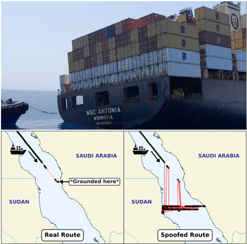
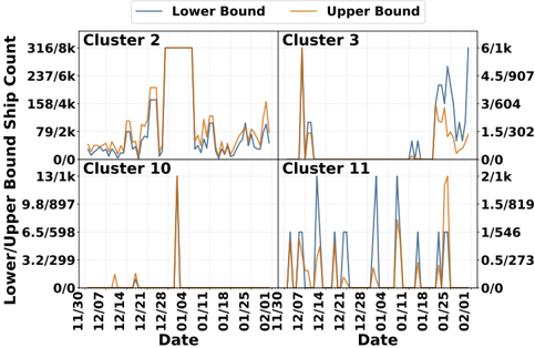
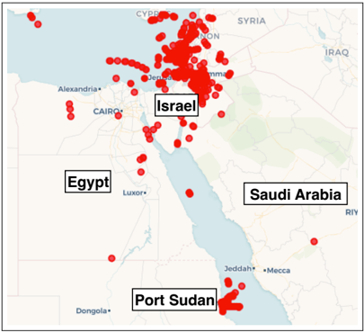
GPS spoofing has emerged as a serious threat to maritime security, yet its global prevalence, persistence, and structure remain largely unmeasured. In this paper, we present the first large-scale measurement study of maritime GPS spoofing, using global Automatic Identification System (AIS) data, which contain the GPS coordinates broadcasted over time by ships across the world. We focus on large-scale regional spoofing, where external interference displaces many vessels across an area at once, leaving a recognizable signature of physically implausible motion correlated across ships; our motion-aware, marine-specific framework identifies this signature and grades the evidence for GPS spoofing in each region it finds. Applying our approach to AIS data from over 367,000 vessels collected between late November 2024 and early February 2025, we identify 31 persistent anomalous hotspots across high-traffic maritime regions, at least 22 of which show strong evidence of GPS spoofing, with spatial and temporal structure aligning with regional conflict and economic sanctions. Notably, our method found that the spoofing activity in the Red Sea responsible for the highly-publicized grounding of the 75,000-ton container ship, MSC Antonia, was ongoing months before the incident, which has not been previously documented. Similarly, we detected persistent spoofing in the Strait of Hormuz over a year before the 2026 Iran war brought commercial shipping through the Strait to near-standstill. Together, this work establishes GPS spoofing as a widespread, recurring, and measurable threat to global maritime navigation.
Overview
CoChat Summary
TL;DR
This paper presents the first large-scale measurement study of maritime GPS spoofing using global AIS data from over 367,000 vessels collected between late November 2024 and early February 2025. It identifies 31 persistent anomalous hotspots worldwide, at least 22 of which show strong evidence of GPS spoofing, including recurring patterns in the Red Sea and Strait of Hormuz that preceded major incidents.
Key findings
- The pipeline produced 17,936 anomaly episodes across 2,663 distinct vessels, totaling 31,328 hours of anomalous operation, and identified 31 persistent anomaly zones; 13 were corroborated spoofing, 9 newly identified spoofing, and 9 suggestive, with at least 22 showing strong evidence of GPS spoofing.
- Most episodes arose from deviation (52%) or speed (45%) violations, while only 3% involved land positions; 71% of episodes lasted less than 60 minutes with a median duration of 40 minutes, and 54% of flagged ships experienced only one episode while roughly 8% had twenty or more.
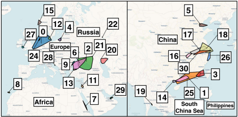
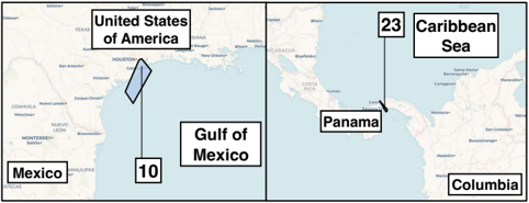
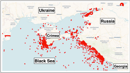
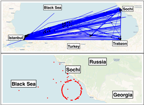
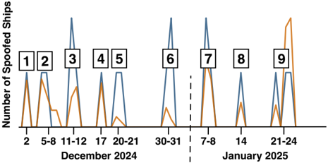
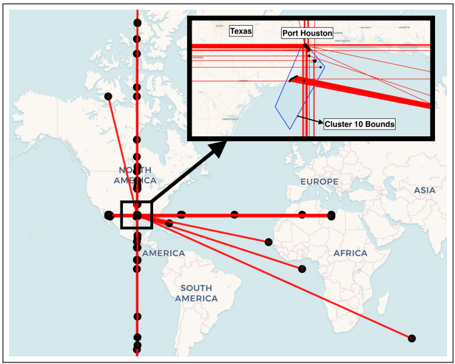
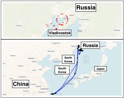
- Hotspots appeared in conflict-adjacent waters such as the Black Sea, Eastern Mediterranean, Red Sea, and East Asian seas, but also in unexpected civilian zones including the Canary Islands, Gulf of Mexico, and Panama Canal; the Gulf of Mexico event on December 31 involved almost 200 vessels with synchronized jumps and was reproduced on NOAA data across 10–634 vessels.
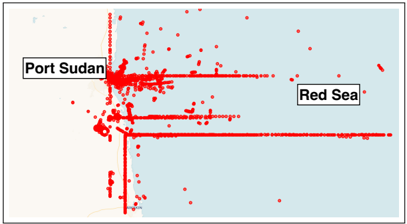
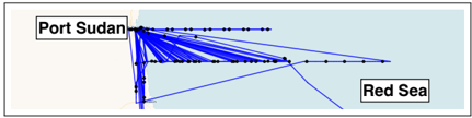
- The Red Sea spoofing near Port Sudan matched the MSC Antonia’s pre-grounding track to the fifth decimal point five months earlier, and sustained Strait of Hormuz anomalies were detected over a year before the 2026 Iran war; sanctions-linked self-spoofing was identified for 16–215 vessels.
Methods
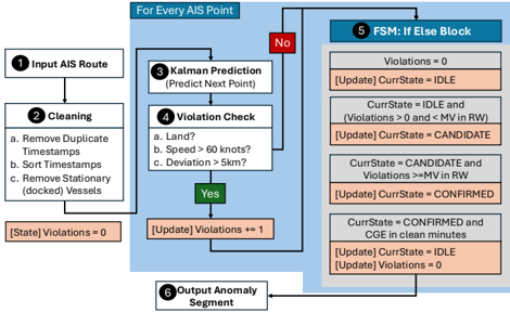
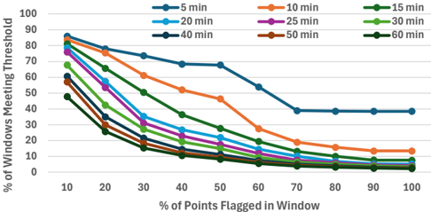
- Two-stage AIS pipeline: Stage 1 analyzes each vessel with a constant-velocity Kalman filter and flags land positions, speeds above 60 knots, and deviations above 5 km; a finite-state machine confirms episodes using a 30-minute rolling window with at least 70% anomalous points and a 120-minute clean-gap end.
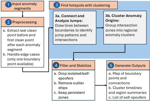
- Stage 2 connects anomaly-segment boundary points into “jump lines,” clusters their spatial intersections with DBSCAN (ε = 50 km, MinPts = 5), filters self-spoofers and outliers, and labels vessels as cluster-associated or self-spoofed/faulty.
- Data come primarily from Spire Global’s global AIS feed from late November 2024 to early February 2025, comprising 379,416 unique vessels, with validation on public NOAA and Danish Maritime Authority regional feeds.
Limitations
- The paper states the framework targets large-scale regional spoofing and may miss displacements smaller than 5 km, episodes shorter than 30 minutes, windows with fewer than 70% anomalous points, and interference affecting only one vessel; measurements are therefore a lower bound on global spoofing activity.
- The authors state the time window cannot capture seasonal or longer-term trends, and because AIS reports the position a receiver computed rather than the received signal, they cannot localize transmitters, attribute interference to specific actors, or observe spoofing-system implementation; geopolitical context is inferred as hypotheses.
- The paper also notes no onboard ground truth exists at scale, so false-positive and missed-detection rates cannot be directly measured; validation relies on independent AIS feeds, documented incidents, dense-port checks, and parameter sensitivity analyses, and AIS coverage is uneven so absence of detected activity is not evidence that a region is free from interference.
Model-written summary. Check it against the paper before relying on it.
Integrity signals
Registry
Cites
Statistics
Figures
Verification
Claims the paper makes
0 Valid · 4 Not valid · 48 Not checked · 169 Own results and interpretations
A result the paper reports from its own data — it cites no other source for it, so there is none to check. The quote shows it is in the paper.
In the paper
“We further find that the small number of residual false positives are primarily attributable to AIS artifacts such as MMSI reuse or faulty transmitters, rather than algorithmic errors”
§ She Spoofed Sea Ships by the Sea Shore: Measuring Large-Scale GPS Spoofing in Global Maritime Traffic > Validation in Dense Maritime Traffic.
plainstates a cause- Asserted: passes — The authors put it forward as true.
- Checkable: passes — It can be checked against evidence.
- Load-bearing: passes — The paper’s conclusions depend on it.
- Based: passes — The paper gives a reason why it holds.
- Rests on 3 assumptions not shown here.
A result the paper reports from its own data — it cites no other source for it, so there is none to check. The quote shows it is in the paper.
In the paper
“Moreover, vessels within each cluster exhibit a shared spoofing-like geometry, with a median of 72% of vessels per cluster following the same displacement pattern despite this operational diversity.”
§ She Spoofed Sea Ships by the Sea Shore: Measuring Large-Scale GPS Spoofing in Global Maritime Traffic > Validation in Dense Maritime Traffic.
plainstates an association- Asserted: passes — The authors put it forward as true.
- Checkable: passes — It can be checked against evidence.
- Load-bearing: passes — The paper’s conclusions depend on it.
- Based: passes — The paper gives a reason why it holds.
- Rests on 3 assumptions not shown here.
None of the sources cited for this claim could be matched to a paper in Crossref, so there is nothing to check it against.
In the paper
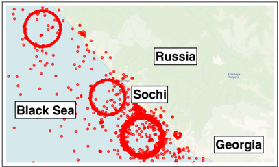
“Most zones appear in geopolitically sensitive areas such as the Black Sea, Eastern Mediterranean, and South China Sea, aligning with regions previously linked to GPS interference and electronic warfare activity [53], [54], [55].”
§ She Spoofed Sea Ships by the Sea Shore: Measuring Large-Scale GPS Spoofing in Global Maritime Traffic > 4.1.1. Maritime Anomaly Hotspots.
What the sources say
- Not matchedcites [53]
Couldn’t be matched to a paper in Crossref, so it can’t be checked.
- Not matchedcites [54]
Couldn’t be matched to a paper in Crossref, so it can’t be checked.
- Not matchedcites [55]
Couldn’t be matched to a paper in Crossref, so it can’t be checked.
hedgedstates an association- Asserted: passes — The authors put it forward as true.
- Checkable: passes — It can be checked against evidence.
- Load-bearing: unclear — It is unclear whether the paper’s conclusions depend on it.
- Based: passes — The paper gives a reason why it holds.
- Not matched
A result the paper reports from its own data — it cites no other source for it, so there is none to check. The quote shows it is in the paper.
In the paper
“Repeating the measurement with many-to-one matching, which permits one cluster to cover several zones, changes the counts by at most three.”
§ She Spoofed Sea Ships by the Sea Shore: Measuring Large-Scale GPS Spoofing in Global Maritime Traffic > 3.4. Stage 2: Anomaly-Zone Clustering
plain- Asserted: passes — The authors put it forward as true.
- Checkable: passes — It can be checked against evidence.
- Load-bearing: unclear — It is unclear whether the paper’s conclusions depend on it.
- Based: passes — The paper gives a reason why it holds.
A result the paper reports from its own data — it cites no other source for it, so there is none to check. The quote shows it is in the paper.
In the paper
“Using the clustering framework described in Section 3.4, we identify 31 persistent anomaly zones (Clusters 0-30) detected across more than two months of AIS traffic.”
§ She Spoofed Sea Ships by the Sea Shore: Measuring Large-Scale GPS Spoofing in Global Maritime Traffic > 4.1.1. Maritime Anomaly Hotspots.
plain- Asserted: passes — The authors put it forward as true.
- Checkable: passes — It can be checked against evidence.
- Load-bearing: passes — The paper’s conclusions depend on it.
- Based: passes — The paper gives a reason why it holds.
92 more claims
Create a free account to see all 221 claims and every source verdict.
- It may state two separate claims as one. 109
- The quote only partly states this claim. 2
- Probably not a substantial claim. 25
Self-check
Percentages, sums and reported differences re-computed from the paper’s own numbers.
Each contradiction between two passages listed here was confirmed by an independent check.
Rated major: it would touch a result — a value a result rests on, reported and recomputed p-values on opposite sides of the significance level, two passages that conflict with no sign which is right, or a cited work retracted before this paper was published.
In the paper
§ She Spoofed Sea Ships by the Sea Shore: Measuring Large-Scale GPS Spoofing in Global Maritime Traffic > 4.1.4. From Anomalies to Spoofing.
“Of 31 zones, 13 are corroborated spoofing, 9 are newly identified spoofing supported by a strong internal signature, and 9 are suggestive.Detailed per-cluster grading appears in Table 6.”
§ She Spoofed Sea Ships by the Sea Shore: Measuring Large-Scale GPS Spoofing in Global Maritime Traffic > Respect for People.
“Baltic | Newly | Sustained cross-vessel coher- | | | (0, 4, 12, 15, 24) | identified | ence; geometric regularity; high | | | | | flag-state diversity | | | Gulf of Mexico | Newly | Cross-shaped jumps across | | | (10) | identified | | | | Caspian Sea (20) | Newly | Crop-circle pattern; consistent | | | | identified | across vessels | |”
Rated minor: it would not touch a result — a value no result rests on, a p-value that stays on the same side of the significance level, or a conflict that is clerical, resolved elsewhere in the paper, or outside its own findings.
In the paper
§ She Spoofed Sea Ships by the Sea Shore: Measuring Large-Scale GPS Spoofing in Global Maritime Traffic > Additional information
“our repository includes a fully reproducible pipeline on NOAA's public AIS data [56], which recovers the Gulf of Mexico spoofing event, and the Danish Maritime Authority's feed [57], which reproduces the Baltic event from open data alone.”
§ She Spoofed Sea Ships by the Sea Shore: Measuring Large-Scale GPS Spoofing in Global Maritime Traffic > References
“56. Spire Global, https://spire.com/. 57. --, "Spire global awarded ca $1.41 million contract from government of canada for ship tracking data," 2024”
Citations
Cites
Still being checked.
Research works printed but not linked: 34
- A. Raymaker, A. Kumar, M. Y. Wong, R. Pickren, A. Chhotaray, F. Li, S. Zonouz, and R. Beyah, "A sea of cyber threats: Maritime cybersecurity from the perspective of mariners," in ACM Conference on Computer and Communications Security (CCS), 2025.
- N. O. Tippenhauer, C. Pöpper, K. B. Rasmussen, and S. Capkun, "On the requirements for successful gps spoofing attacks," in ACM Con- ference on Computer and Communications Security (CCS), 2011.
- K. C. Zeng, S. Liu, Y. Shu, D. Wang, H. Li, Y. Dou, G. Wang, and Y. Yang, "All your gps are belong to us: Towards stealthy manipulation of road navigation systems," in USENIX Security, 2018.
- H. Sathaye, M. Strohmeier, V. Lenders, and A. Ranganathan, "An experimental study of gps spoofing and takeover attacks on uavs," in USENIX Security, 2022.
- M. Balduzzi, A. Pasta, and K. Wilhoit, "A security evaluation of ais automated identification system," in Proceedings of the 30th annual computer security applications conference, 2014.
- J. Pavur, D. Moser, M. Strohmeier, V. Lenders, and I. Martinovic, "A tale of sea and sky on the security of maritime vsat communications," in IEEE Symposium on Security and Privacy (S&P), 2020.
- S. Liu, X. Cheng, H. Yang, Y. Shu, X. Weng, P. Guo, K. C. Zeng, G. Wang, and Y. Yang, "Stars can tell: a robust method to defend against gps spoofing attacks using off-the-shelf chipset," in USENIX Security, 2021.
- B. Davidovich, B. Nassi, and Y. Elovici, "Visas-detecting gps spoof- ing attacks against drones by analyzing camera's video stream," in Network and Distributed System Security Symposium (NDSS), 2022.
- E. Lee, A. J. Mokashi, S. Y. Moon, and G. Kim, "The maturity of automatic identification systems (ais) and its implications for innovation," Journal of Marine Science and Engineering, 2019.
- K. Tran, S. Keene, E. Fretheim, and M. Tsikerdekis, "Marine network protocols and security risks," in Journal of Cybersecurity and Privacy, 2021.
- I. Progoulakis, P. Rohmeyer, and N. Nikitakos, "Cyber physical systems security for maritime assets," in Journal of Marine Science and Engineering, 2021.
- J. DiRenzo, D. A. Goward, and F. S. Roberts, "The little-known challenge of maritime cyber security," in International Conference on Information, Intelligence, Systems and Applications (IISA), 2015.
- H. Zheng, Q. Hu, C. Yang, Q. Mei, P. Wang, and K. Li, "Identifi- cation of spoofing ships from automatic identification system data via trajectory segmentation and isolation forest," Journal of Marine Science and Engineering, 2023.
- A. Androjna, I. Pavić, L. Gucma, P. Vidmar, and M. Perkovič, "Ais data manipulation in the illicit global oil trade," Journal of Marine Science and Engineering, 2023.
- J. Bhatti and T. E. Humphreys, "Hostile control of ships via false gps signals: Demonstration and detection," NAVIGATION: Journal of the Institute of Navigation, 2017.
- Y. Xu, X. Han, G. Deng, J. Li, Y. Liu, and T. Zhang, "Sok: Rethinking sensor spoofing attacks against robotic vehicles from a systematic view," in IEEE European Symposium on Security and Privacy (EuroS&P), 2023.
- Y. Xu, G. Deng, X. Han, G. Li, H. Qiu, and T. Zhang, "Physcout: Detecting sensor spoofing attacks via spatio-temporal consistency," in ACM Conference on Computer and Communications Security (CCS), 2024.
- J. Spravil, C. Hemminghaus, M. von Rechenberg, E. Padilla, and J. Bauer, "Detecting maritime gps spoofing attacks based on nmea sentence integrity monitoring," Journal of Marine Science and En- gineering, 2023.
- M. L. Psiaki and T. E. Humphreys, "Gnss spoofing and detection," Proceedings of the IEEE, 2016.
- S. Narain, A. Ranganathan, and G. Noubir, "Security of gps/ins based on-road location tracking systems," in IEEE Symposium on Security and Privacy (S&P), 2019.
- J. Shen, J. Y. Won, Z. Chen, and Q. A. Chen, "Drift with devil: Security of multi-sensor fusion based localization in high-level autonomous driving under gps spoofing," in USENIX Security, 2020.
- J. Yang, A. Estornell, and Y. Vorobeychik, "Location spoofing attacks on autonomous fleets," in Symposium on Vehicles Security and Privacy, 2023.
- C. Tibaldo, H. Sathaye, G. Camurati, and S. Capkun, "Gnss-wasp: Gnss wide area spoofing," in USENIX Security, 2025.
- J. Zhang, S. Cheng, L. Hu, J. Zhang, C. Shi, X. Han, T. Zhang, Y. Cheng, and W. Zhang, "The ghost navigator: Revisiting the hidden vulnerability of localization in autonomous driving," in USENIX Security, 2025.
- H. Sathaye, G. LaMountain, P. Closas, and A. Ranganathan, "Sem- perfi: Anti-spoofing gps receiver for uavs," in Network and Dis- tributed System Security Symposium (NDSS), 2022.
- K. Jansen, M. Schäfer, D. Moser, V. Lenders, C. Pöpper, and J. Schmitt, "Crowd-gps-sec: Leveraging crowdsourcing to detect and localize gps spoofing attacks," in IEEE Symposium on Security and Privacy (S&P), 2018.
- D. Coppola, A. Mumtaz, G. Camurati, H. Sathaye, M. Singh, and S. Capkun, "Leo-range: Physical layer design for secure ranging with low earth orbiting satellites," in USENIX Security, 2025.
- X. Cheng, H. Yang, S. Liu, and Y. Yang, "Distributed multi-antenna gps spoofing attack using off-the-shelf devices," in ACM Conference on Security and Privacy in Wireless and Mobile Networks, 2025.
- --, "Spire global awarded ca $1.41 million contract from government of canada for ship tracking data," 2024, https://ir.spire.com/news-events/press-releases/detail/227/spire- global-awarded-ca-1-41-million-contract-from.
- R. Bansal, "Deriving and testing the great circle theory," Interna- tional Journal of Statistics and Applied Mathematics, 2021.
- M. Ester, H.-P. Kriegel, J. Sander, X. Xu et al., "A density-based algorithm for discovering clusters in large spatial databases with noise," in KDD, 1996.
- E. Schubert, J. Sander, M. Ester, H. P. Kriegel, and X. Xu, "Dbscan revisited, revisited: why and how you should (still) use dbscan," ACM Transactions on Database Systems (TODS), 2017.
- I. Ibañez, "Teaching celestial navigation in the age of gnss," TransNav: International Journal on Marine Navigation and Safety of Sea Transportation, 2018.
- D.-I. F. Wirz, "Optimisation of the crash-stop manoeuvre of ves- sels employing slow-speed two-stroke engines and fixed pitch pro- pellers," Journal of Marine Engineering & Technology, 2012.
Cited by
Still being checked.
Metadata
- Authors
- Raymaker, A., Von Brock, R., Pickren, R., Chhotaray, A., Li, F., Zonouz, S., & Beyah, R.
- Affiliations
- Georgia Institute of Technology (US)
- Venue
- arXiv
- Publisher
- arXiv
- Published
- 2026
- ISSN
- 2331-8422 (ISSN-L)
- arXiv
- 2609.37676
- OpenAlex
- W7214931993
- Cited by
- 0
- References
- 0
- Type
- posted content
- Language
- en
- Open access
- green
- arxiv.org
- Licence
- Locations
- arXiv (Cornell University) (submittedVersion, cc-by)
- arXiv (Cornell University) (cc-by)
- Topics
- Physical Sciences › Engineering › Aerospace Engineering › GNSS positioning and interference
- Physical Sciences › Engineering › Ocean Engineering › Maritime Navigation and Safety
- Social Sciences › Political Science and International Relations › Maritime Security and History
- Keywords
- GPS spoofing, maritime security, Automatic Identification System, vessel tracking, Red Sea, Strait of Hormuz, economic sanctions, maritime conflict
About these checks
Registry, retraction, Cites and statistics results are computed, not judged, with one exception: a printed reference that no index lists is read once by a model before it counts as a citation error. Claims are extracted by a model and kept only when their quote appears verbatim in the text; each cited source is then checked, with a model’s help, for whether it says what the claim relies on. Those verdicts can be wrong — read the claim’s quote and the cited source before relying on one.
A language model drew the claims from the paper on 2026-11-14, under version 3 of the claim definition (model deepseek-v4.1-flash, prompt extract-v3).
A second model labelled each claim on 2026-11-14 (model jev-1.13-20260917, definition revision gold-guideline-v0.2).
Statistics and arithmetic are recomputed, not judged.
Confidence bands are shown only for fields calibrated on our annotated test set. None is calibrated yet, so no band is shown.
What counts as a claim ›How we measure confidence ›How we check this ›
Are you an author, or do you see a problem with this page? Request a review
Data sources
Bibliographic data: Semantic Scholar, OpenAlex, Crossref.
Contains information from the Semantic Scholar Academic Graph Datasets, made available under the ODC Attribution License (ODC-BY 1.0).
Semantic Scholar’s data is described in: Kinney, R., et al. (2023). The Semantic Scholar Open Data Platform. arXiv:2301.10140.
