

The DOI matches its Crossref record; 17 of the 17 references it cites were found in a registry or an index; none of the 31 sources its claims cite is checked for support yet.
“El camino hacia el santuario incaico del llullaillaco”: el complejo arqueológico más alto del mundo analizado a través de un SIG
Open accessAbstract
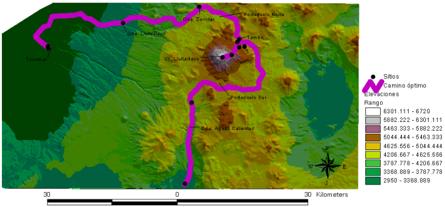
As a contribution to the high altitude Inca archaeology we made surveys in the base, intermediate heights and the surroundings of the Llullaillaco volcano, with the purpose of elucidating the paths followed by the ancient worshippers in their approachment to the shrine. Through a GIS platform we made a distributional analysis in order to find a terrain occupational pattern. As a result, we determined that the archaeological sites that were found in our surveys and the ones that form the Llullaillaco complex are located along the optimal path for approaching and ascending to the summit.
Overview
AI snapshot
Written from the paper’s full text.
TL;DR
This paper uses GIS least-cost path and network analysis to model optimal routes to the Inca sanctuary on Llullaillaco, the world’s highest archaeological complex. It finds that known archaeological structures and the ascent route align with low-slope, sheltered, high-insolation, water-adjacent terrain, and argues the main circulation axis was north–south from San Pedro de Atacama toward Copiapó rather than from the eastern Argentine Puna.
Key findings
- Llullaillaco volcano reaches 6,739 masl, is the highest volcano in the world and third-highest mountain in South America, and its summit holds the world’s highest archaeological site; the complex comprises 45 structures along a 10 km path, with three preserved human bodies and more than 140 sumptuary objects found in 1999.
- GIS least-cost path and network analysis produced an optimal route that coincides with surveyed archaeological sites and the “ruta arqueológica” to the summit; structures cluster near water (distance mode 1–400 m, n=33, 71.7%), in physiographic shelter (n=22, 47.8%), on low slopes (0.01–10.12°, n=14, 43.8%), and in areas receiving up to 11 hours of daily sun (n=17, 37%).
- Chi-square tests indicate the distribution is not random: Fisiografía χ²=39.667, df=5; Distancia χ²=56.956, df=3; Orientación χ²=32.622, df=6; Pendiente χ²=41.111, df=4; all Asymp. Sig. = .000.
- The paper concludes the circulation network did not come from the east (Argentine dry Puna) but formed part of a north–south axis linking the fertile oases of San Pedro de Atacama with Copiapó; the nearly 400 km chain of volcanoes was included in Andean circulation through the Despoblado de Atacama, likely motivated by caravan traffic within mining exploitation.
Methods
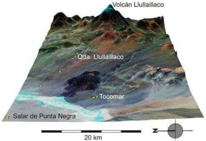
- Field surveys were conducted at the base, intermediate heights, and sectors near the Llullaillaco volcano, focusing on quebradas draining into the Salar de Punta Negra basin in Chile’s 2nd Region (Antofagasta).
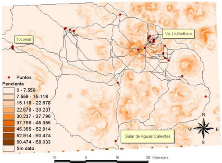
- A GIS analysis used an ASTER DEM GeoTIFF (1 arc-second, ~30 m grid; WGS84/EGM96; NASA; vertical precision 20 m at 95% confidence, horizontal 30 m at 95% confidence). Slope and river/flow-accumulation maps were combined by map algebra into a friction surface (water=1, no water=0), then least-cost path and network analysis with a cost-economy algorithm identified optimal approach and ascent routes.
- Chi-square tests assessed whether 46 recorded structures, classified into 7 types, were distributed non-randomly relative to physiography, distance, aspect, and slope.
Limitations
- Stated: the paper calls for new surveys and excavations of nearby sites to compare cultural components and sequences, in order to clarify the origin of the intervening material culture and the historical beginnings of mountain cult.
- Stated: high-mountain archaeology is described as germinal and limited by data provenance, with many cases deriving from illegal excavations or amateur work.
- Evident from the text: the friction surface models only slope and rivers/streams, so other potentially relevant variables are not included; the DEM’s vertical and horizontal precision is 20 m and 30 m at 95% confidence, respectively.
Model-written summary. Check it against the paper before relying on it.
Integrity signals
Registry
Cites
Statistics
Figures
Verification
Claims the paper makes
26 Sources not found · 24 Own result · 9 Own interpretation · 4 No basis given · 1 Not checked yet
A result the paper reports from its own data — it cites no other source for it, so there is none to check. The quote shows it is in the paper.
In the paper
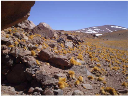
“Posee como evidencia arqueológica mojones y parapetos en ambos flancos que marcan el descenso hacia la aguada.”
§ "El camino hacia el Santuario Incaico del Llullaillaco": el complejo arqueológico más alto del mundo analizado a través de un SIG > 4.2 Quebrada de Llullaillaco (3552 mmsnm)
plain- Asserted: passes — The authors put it forward as true.
- Checkable: passes — It can be checked against evidence.
- Load-bearing: unclear — It is unclear whether the paper’s conclusions depend on it.
- Based: passes — The paper gives a reason why it holds.
A result the paper reports from its own data — it cites no other source for it, so there is none to check. The quote shows it is in the paper.
In the paper
“Como corolario, pudimos determinar que los sitios arqueológicos reconocidos en nuestras tareas de campo y los propios del complejo Llullaillaco se ubican en el camino óptimo de acercamiento al volcán y ascenso a la cima.”
§ "El camino hacia el Santuario Incaico del Llullaillaco": el complejo arqueológico más alto del mundo analizado a través de un SIG > Abstract
plaincorrelational- Asserted: passes — The authors put it forward as true.
- Checkable: passes — It can be checked against evidence.
- Load-bearing: passes — The paper’s conclusions depend on it.
- Based: passes — The paper gives a reason why it holds.
- Rests on an assumption: The least-cost paths calculated from slope and water variables correspond to the routes actually used by ancient worshippers to approach and ascend Llullaillaco.
A result the paper reports from its own data — it cites no other source for it, so there is none to check. The quote shows it is in the paper.
In the paper
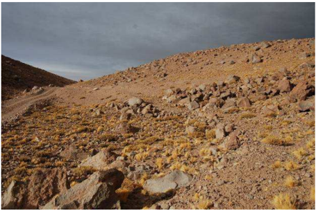
“La aguada que descansa al fondo de la quebrada presenta como evidencia arqueológica un tramo de camino incaico que desciende de las laderas para aprovechar el curso de agua y las pasturas, en el angostamiento de la quebrada, hacia el suroeste de un refugio actual de la CONAF.”
§ "El camino hacia el Santuario Incaico del Llullaillaco": el complejo arqueológico más alto del mundo analizado a través de un SIG > 4.1 Quebrada Zorritas
plaindirect- Asserted: passes — The authors put it forward as true.
- Checkable: passes — It can be checked against evidence.
- Load-bearing: unclear — It is unclear whether the paper’s conclusions depend on it.
- Based: passes — The paper gives a reason why it holds.
A result the paper reports from its own data — it cites no other source for it, so there is none to check. The quote shows it is in the paper.
In the paper
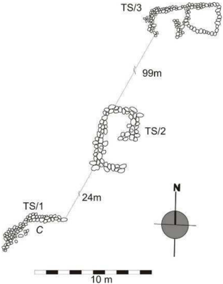
“El segundo conjunto de estructuras, TS (Tocomar Sur) se sitúa en el fondo de la quebrada seca, la cual discurre hacia el Salar de Punta Negra en dirección oeste-este.”
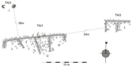
§ "El camino hacia el Santuario Incaico del Llullaillaco": el complejo arqueológico más alto del mundo analizado a través de un SIG > Figura 5: Conjunto TN, refugios y estructuras rituales.
plain- Asserted: passes — The authors put it forward as true.
- Checkable: passes — It can be checked against evidence.
- Load-bearing: unclear — It is unclear whether the paper’s conclusions depend on it.
- Based: passes — The paper gives a reason why it holds.
A result the paper reports from its own data — it cites no other source for it, so there is none to check. The quote shows it is in the paper.
In the paper
“No se encontró cerámica.”
§ "El camino hacia el Santuario Incaico del Llullaillaco": el complejo arqueológico más alto del mundo analizado a través de un SIG > 4.2 Quebrada de Llullaillaco (3552 mmsnm)
plain- Asserted: passes — The authors put it forward as true.
- Checkable: passes — It can be checked against evidence.
- Load-bearing: unclear — It is unclear whether the paper’s conclusions depend on it.
- Based: passes — The paper gives a reason why it holds.
A result the paper reports from its own data — it cites no other source for it, so there is none to check. The quote shows it is in the paper.
In the paper
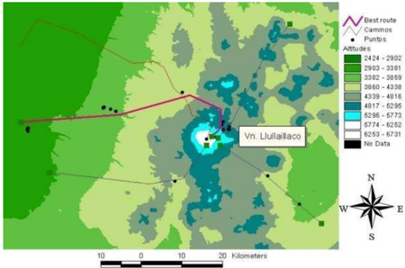
“Trazamos sobre el DEM rutas convergentes conectando las concentraciones de estructuras identificadas.Luego, un algoritmo de economía de coste eligió entre ellos la mejor ruta de ascenso, que coincide con la llamada”
§ "El camino hacia el Santuario Incaico del Llullaillaco": el complejo arqueológico más alto del mundo analizado a través de un SIG > Test Statistics
plaincorrelationalSingle case- Asserted: passes — The authors put it forward as true.
- Checkable: passes — It can be checked against evidence.
- Load-bearing: passes — The paper’s conclusions depend on it.
- Based: passes — The paper gives a reason why it holds.
- Rests on an assumption: El modelo de camino de menor coste y el análisis de redes sobre el DEM representan adecuadamente la transitabilidad y las rutas de circulación prehispánicas en el área.
- Rests on an assumption: Las estructuras arqueológicas registradas son de filiación incaica y su distribución refleja decisiones de los constructores-usuarios del santuario.
- Rests on an assumption: Las condiciones ambientales actuales (pendiente, insolación, cursos de agua) son equivalentes a las del período incaico.
A result the paper reports from its own data — it cites no other source for it, so there is none to check. The quote shows it is in the paper.
In the paper
“Estas estructuras no se distribuyen en el paisaje de forma azarosa, sino que lo hacen en relación a distintas variables ambientales, principalmente los ríos, la fisiografía, la insolación y la pendiente.”
§ "El camino hacia el Santuario Incaico del Llullaillaco": el complejo arqueológico más alto del mundo analizado a través de un SIG > 5. Análisis de distribuciones y de transitabilidad
plaincorrelational- Asserted: passes — The authors put it forward as true.
- Checkable: passes — It can be checked against evidence.
- Load-bearing: passes — The paper’s conclusions depend on it.
- Based: passes — The paper gives a reason why it holds.
In the paper
“El siguiente paso fue la aplicación del algoritmo de camino de menor coste sobre la combinación de ambas variables, cuyo resultado es el trazado de un camino óptimo que coincide al detalle con los sitios relevados por nosotros.”
§ "El camino hacia el Santuario Incaico del Llullaillaco": el complejo arqueológico más alto del mundo analizado a través de un SIG > Test Statistics
What the sources say
- Not matchedcites WHEATLEY y GILLINGS, 2004: 142
Couldn’t be matched to a paper in Crossref, so it can’t be checked.
plaindirectSingle case- Asserted: passes — The authors put it forward as true.
- Checkable: passes — It can be checked against evidence.
- Load-bearing: passes — The paper’s conclusions depend on it.
- Based: passes — The paper gives a reason why it holds.
- Rests on an assumption: El modelo de camino de menor coste y el análisis de redes sobre el DEM representan adecuadamente la transitabilidad y las rutas de circulación prehispánicas en el área.
- Rests on an assumption: Las condiciones ambientales actuales (pendiente, insolación, cursos de agua) son equivalentes a las del período incaico.
- Not matched
None of the sources cited for this claim have been checked yet.
In the paper
“Esto significa que a nivel estilo la cerámica es contemporánea de la hallada en el volcán Llullaillaco, sobre todo en la base (sitio Cementerio y Tambo, MIGNONE, 2010).”
§ "El camino hacia el Santuario Incaico del Llullaillaco": el complejo arqueológico más alto del mundo analizado a través de un SIG > Figura 5: Conjunto TN, refugios y estructuras rituales.
What the sources say
- Not checked yetcites MIGNONE, 2010 source
Checked before — its earlier verdict is held back until a new check runs.
plaincorrelational- Asserted: passes — The authors put it forward as true.
- Checkable: passes — It can be checked against evidence.
- Load-bearing: unclear — It is unclear whether the paper’s conclusions depend on it.
- Based: passes — The paper gives a reason why it holds.
- Not checked yet
In the paper
“El recuento de estas estructuras nos permite vislumbrar diferencias en cuanto al trazado y la arquitectura.”
§ "El camino hacia el Santuario Incaico del Llullaillaco": el complejo arqueológico más alto del mundo analizado a través de un SIG > 4. Algunos antecedentes de investigación
What the sources say
- Not matchedcites VITRY, 2004
Couldn’t be matched to a paper in Crossref, so it can’t be checked.
plaincorrelational- Asserted: passes — The authors put it forward as true.
- Checkable: passes — It can be checked against evidence.
- Load-bearing: unclear — It is unclear whether the paper’s conclusions depend on it.
- Based: passes — The paper gives a reason why it holds.
- Not matched
In the paper
“Por su parte, los grupos incluidos en la cerámica Roja Violácea corresponderían a una misma industria alfarera que caracteriza al período Intermedio Tardío, desde la cuenca del Loa hasta el Salar de Atacama, y que se prolongaría hasta la llegada de los incas.”
§ "El camino hacia el Santuario Incaico del Llullaillaco": el complejo arqueológico más alto del mundo analizado a través de un SIG > Figura 5: Conjunto TN, refugios y estructuras rituales.
What the sources say
- Not matchedcites URIBE, 2002
Couldn’t be matched to a paper in Crossref, so it can’t be checked.
hedgedcorrelational- Asserted: passes — The authors put it forward as true.
- Checkable: passes — It can be checked against evidence.
- Load-bearing: unclear — It is unclear whether the paper’s conclusions depend on it.
- Based: passes — The paper gives a reason why it holds.
- Not matched
In the paper
“La presencia de estas construcciones está contemplada en las fuentes etnohistóricas, sobre todo en la región bajo estudio.”
§ "El camino hacia el Santuario Incaico del Llullaillaco": el complejo arqueológico más alto del mundo analizado a través de un SIG > Figura 5: Conjunto TN, refugios y estructuras rituales.
What the sources say
- Not matchedcites SANHUEZA, 2004: 490
Couldn’t be matched to a paper in Crossref, so it can’t be checked.
plain- Asserted: passes — The authors put it forward as true.
- Checkable: passes — It can be checked against evidence.
- Load-bearing: unclear — It is unclear whether the paper’s conclusions depend on it.
- Based: passes — The paper gives a reason why it holds.
- Not matched
A conclusion the paper draws from its own results — it cites no other source for it, so there is none to check. The quote shows it is in the paper.
In the paper
“La red de volcanes que se suceden en casi 400 km a lo largo de esta línea, quedaron incluidos en el entramado de la circulación andina por el Despoblado de Atacama, motivada seguramente por el tráfico de caravanas dentro de la epxlotación minera.”
§ "El camino hacia el Santuario Incaico del Llullaillaco": el complejo arqueológico más alto del mundo analizado a través de un SIG > 6. Conclusión
hedgedconditional- Asserted: passes — The authors put it forward as true.
- Checkable: passes — It can be checked against evidence.
- Load-bearing: passes — The paper’s conclusions depend on it.
- Based: unclear — It is unclear why the paper says it holds.
A conclusion the paper draws from its own results — it cites no other source for it, so there is none to check. The quote shows it is in the paper.
In the paper
“Estas características del conocimiento geográfico que podemos colegir de la distribución arquitectónica, nos habla de la selección y planificación de escenarios para los rituales de altura.”
§ "El camino hacia el Santuario Incaico del Llullaillaco": el complejo arqueológico más alto del mundo analizado a través de un SIG > 6. Conclusión
plaincorrelationalSingle case- Asserted: passes — The authors put it forward as true.
- Checkable: passes — It can be checked against evidence.
- Load-bearing: passes — The paper’s conclusions depend on it.
- Based: passes — The paper gives a reason why it holds.
A conclusion the paper draws from its own results — it cites no other source for it, so there is none to check. The quote shows it is in the paper.
In the paper
“Ambas técnicas nos muestran que las estructuras se ubican en aquellos espacios en los que el tránsito se ve facilitado por pendientes menores.”
§ "El camino hacia el Santuario Incaico del Llullaillaco": el complejo arqueológico más alto del mundo analizado a través de un SIG > Test Statistics
plaincorrelational- Asserted: passes — The authors put it forward as true.
- Checkable: passes — It can be checked against evidence.
- Load-bearing: passes — The paper’s conclusions depend on it.
- Based: passes — The paper gives a reason why it holds.
- Rests on an assumption: El modelo de camino de menor coste y el análisis de redes sobre el DEM representan adecuadamente la transitabilidad y las rutas de circulación prehispánicas en el área.
A conclusion the paper draws from its own results — it cites no other source for it, so there is none to check. The quote shows it is in the paper.
In the paper
“pudiéndose seguir todo un derrotero de movilidad pre y posthispánico a través de los refugios semicirculares y de las”
§ "El camino hacia el Santuario Incaico del Llullaillaco": el complejo arqueológico más alto del mundo analizado a través de un SIG > 4.4 Quebrada de Aguas Calientes (4243 msnm).
plaincorrelational- Asserted: passes — The authors put it forward as true.
- Checkable: passes — It can be checked against evidence.
- Load-bearing: passes — The paper’s conclusions depend on it.
- Based: passes — The paper gives a reason why it holds.
- It may state two separate claims as one. 36
- Probably not a substantial claim. 24
A result the paper reports from its own data — it cites no other source for it, so there is none to check. The quote shows it is in the paper.
In the paper
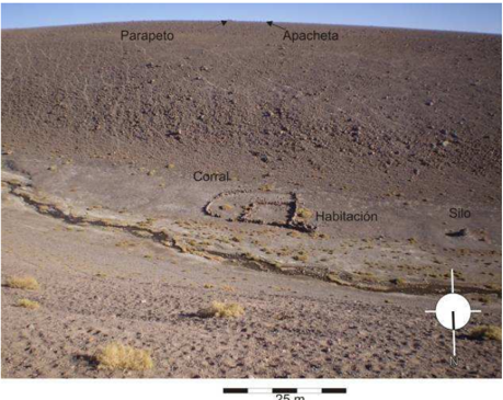
“Desde el sur, dos parapetos semilunares (1,5 m de largo con ancho regular de muro de 35 cm) marcan el descenso a la quebrada y se alinean con huellas de ganado en zig-zag que llegan al fondo de la falla, a un corral adosado a dos habitaciones pequeñas y una estructura tronco-cónica de almacenamiento, ubicadas en la margen sur del río.”
§ "El camino hacia el Santuario Incaico del Llullaillaco": el complejo arqueológico más alto del mundo analizado a través de un SIG > 4.2 Quebrada de Llullaillaco (3552 mmsnm)
plaincorrelational- Asserted: passes — The authors put it forward as true.
- Checkable: passes — It can be checked against evidence.
- Load-bearing: unclear — It is unclear whether the paper’s conclusions depend on it.
- Based: passes — The paper gives a reason why it holds.
It may state two separate claims as one.
A result the paper reports from its own data — it cites no other source for it, so there is none to check. The quote shows it is in the paper.
In the paper
“En la quebrada de Zorritas (4.123 msnm), ubicada en la vertiente occidental del volcán Llullaillaco y a 15 km de este macizo, encontramos una amplia depresión surcada por un profuso pastizal alimentado por una de las aguadas más importantes de la zona.”
§ "El camino hacia el Santuario Incaico del Llullaillaco": el complejo arqueológico más alto del mundo analizado a través de un SIG > 4.1 Quebrada Zorritas
plain- Asserted: passes — The authors put it forward as true.
- Checkable: passes — It can be checked against evidence.
- Load-bearing: unclear — It is unclear whether the paper’s conclusions depend on it.
- Based: passes — The paper gives a reason why it holds.
It may state two separate claims as one.
A result the paper reports from its own data — it cites no other source for it, so there is none to check. The quote shows it is in the paper.
In the paper
“Dentro de estos conjuntos se encontraron petroglifos, herraduras de vacuno, fragmentos óseos, dos raspadores (uno de riolita y otro de basalto) y una punta de proyectil fragmentada de sílice.”
§ "El camino hacia el Santuario Incaico del Llullaillaco": el complejo arqueológico más alto del mundo analizado a través de un SIG > 4.2 Quebrada de Llullaillaco (3552 mmsnm)
plain- Asserted: passes — The authors put it forward as true.
- Checkable: passes — It can be checked against evidence.
- Load-bearing: unclear — It is unclear whether the paper’s conclusions depend on it.
- Based: passes — The paper gives a reason why it holds.
It may state two separate claims as one.
A result the paper reports from its own data — it cites no other source for it, so there is none to check. The quote shows it is in the paper.
In the paper
“A 6,7 km al suroeste del extremo meridional del Salar de Punta Negra, en una quebrada de casi 200 m de ancho y 30 m de profundidad que desagua en él, encontramos una serie de estructuras derruidas en ambos márgenes, con evidencia material prehispánica consistente en puntas de proyectil, cerámica y metal.”
§ "El camino hacia el Santuario Incaico del Llullaillaco": el complejo arqueológico más alto del mundo analizado a través de un SIG > 4.3 Pampa de Tocomar (3324 msnm).
plain- Asserted: passes — The authors put it forward as true.
- Checkable: passes — It can be checked against evidence.
- Load-bearing: unclear — It is unclear whether the paper’s conclusions depend on it.
- Based: passes — The paper gives a reason why it holds.
It may state two separate claims as one.
A result the paper reports from its own data — it cites no other source for it, so there is none to check. The quote shows it is in the paper.
In the paper
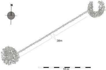
“Ambas mantienen, sin embargo, una altura de 60 cm y un diámetro de 3 m.”
§ "El camino hacia el Santuario Incaico del Llullaillaco": el complejo arqueológico más alto del mundo analizado a través de un SIG > Figura 5: Conjunto TN, refugios y estructuras rituales.
plain- Asserted: passes — The authors put it forward as true.
- Checkable: passes — It can be checked against evidence.
- Load-bearing: fails — The paper’s conclusions may not depend on it.
- Based: passes — The paper gives a reason why it holds.
Probably not a substantial claim. The paper’s conclusions may not depend on it. It may state two separate claims as one.
A result the paper reports from its own data — it cites no other source for it, so there is none to check. The quote shows it is in the paper.
In the paper
“Están separadas entre sí por 38 m y forman una línea que se orienta a 59º del Norte magnético.”
§ "El camino hacia el Santuario Incaico del Llullaillaco": el complejo arqueológico más alto del mundo analizado a través de un SIG > Figura 5: Conjunto TN, refugios y estructuras rituales.
plain- Asserted: passes — The authors put it forward as true.
- Checkable: passes — It can be checked against evidence.
- Load-bearing: fails — The paper’s conclusions may not depend on it.
- Based: passes — The paper gives a reason why it holds.
Probably not a substantial claim. The paper’s conclusions may not depend on it. It may state two separate claims as one.
A result the paper reports from its own data — it cites no other source for it, so there is none to check. The quote shows it is in the paper.
In the paper
“Una de ellas, la oeste, se encuentra parcialmente destruida por la acción de una pala mecánica cuyas huellas se mantienen perfectamente visibles.”
§ "El camino hacia el Santuario Incaico del Llullaillaco": el complejo arqueológico más alto del mundo analizado a través de un SIG > Figura 5: Conjunto TN, refugios y estructuras rituales.
plaindirect- Asserted: passes — The authors put it forward as true.
- Checkable: passes — It can be checked against evidence.
- Load-bearing: fails — The paper’s conclusions may not depend on it.
- Based: passes — The paper gives a reason why it holds.
Probably not a substantial claim. The paper’s conclusions may not depend on it.
A result the paper reports from its own data — it cites no other source for it, so there is none to check. The quote shows it is in the paper.
In the paper
“El registro de superficie es escueto tanto en el conjunto TN como en el TS: se encontraron fragmentos cerámicos café-gris, engobe rojo pulido exterior -naranja alisado interior, un fragmento con pintura negra sobre una pasta anaranjada, sin pulir y un último fragmento con un espeso englobe blanco.”
§ "El camino hacia el Santuario Incaico del Llullaillaco": el complejo arqueológico más alto del mundo analizado a través de un SIG > Figura 5: Conjunto TN, refugios y estructuras rituales.
plain- Asserted: passes — The authors put it forward as true.
- Checkable: passes — It can be checked against evidence.
- Load-bearing: unclear — It is unclear whether the paper’s conclusions depend on it.
- Based: passes — The paper gives a reason why it holds.
It may state two separate claims as one.
A result the paper reports from its own data — it cites no other source for it, so there is none to check. The quote shows it is in the paper.
In the paper
“Están ubicadas a 500 m del conjunto TS y dominan la pampa circundante.”
§ "El camino hacia el Santuario Incaico del Llullaillaco": el complejo arqueológico más alto del mundo analizado a través de un SIG > Figura 5: Conjunto TN, refugios y estructuras rituales.
plain- Asserted: passes — The authors put it forward as true.
- Checkable: passes — It can be checked against evidence.
- Load-bearing: unclear — It is unclear whether the paper’s conclusions depend on it.
- Based: passes — The paper gives a reason why it holds.
It may state two separate claims as one.
A result the paper reports from its own data — it cites no other source for it, so there is none to check. The quote shows it is in the paper.
In the paper
“Fueron hallados también pequeños fragmentos de mineral de cobre, una pinza metálica de cabeza semilunar, una punta incompleta de basalto triangular y una pieza lítica de la misma composición, probable nódulo, que presenta las huellas en negativo del desbaste.”
§ "El camino hacia el Santuario Incaico del Llullaillaco": el complejo arqueológico más alto del mundo analizado a través de un SIG > Figura 5: Conjunto TN, refugios y estructuras rituales.
plain- Asserted: passes — The authors put it forward as true.
- Checkable: passes — It can be checked against evidence.
- Load-bearing: unclear — It is unclear whether the paper’s conclusions depend on it.
- Based: passes — The paper gives a reason why it holds.
It may state two separate claims as one.
A result the paper reports from its own data — it cites no other source for it, so there is none to check. The quote shows it is in the paper.
In the paper
“Sobre el lado derecho, norte, y 1 km hacia el oeste, se encuentran dos apachetas y un refugio cerrado que marcan la unión de la quebrada Llullaillaco con una quebrada subsidiaria de menores dimensiones”
§ "El camino hacia el Santuario Incaico del Llullaillaco": el complejo arqueológico más alto del mundo analizado a través de un SIG > 4.2 Quebrada de Llullaillaco (3552 mmsnm)
plain- Asserted: passes — The authors put it forward as true.
- Checkable: passes — It can be checked against evidence.
- Load-bearing: unclear — It is unclear whether the paper’s conclusions depend on it.
- Based: passes — The paper gives a reason why it holds.
It may state two separate claims as one.
A result the paper reports from its own data — it cites no other source for it, so there is none to check. The quote shows it is in the paper.
In the paper
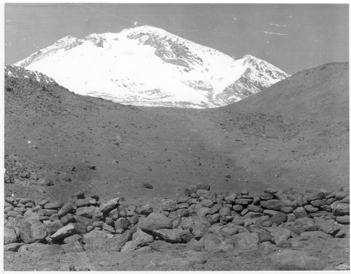
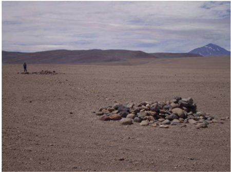
“Desde ellas puede verse erguirse el volcán Llullaillaco entre la geografía adyacente.”
§ "El camino hacia el Santuario Incaico del Llullaillaco": el complejo arqueológico más alto del mundo analizado a través de un SIG > Figura 5: Conjunto TN, refugios y estructuras rituales.
plain- Asserted: passes — The authors put it forward as true.
- Checkable: passes — It can be checked against evidence.
- Load-bearing: fails — The paper’s conclusions may not depend on it.
- Based: passes — The paper gives a reason why it holds.
Probably not a substantial claim. The paper’s conclusions may not depend on it.
A result the paper reports from its own data — it cites no other source for it, so there is none to check. The quote shows it is in the paper.
In the paper
“El estadístico χ 2 permite concluir que la distribución por el paisaje no es fruto del azar, sino de una selección cuidadosa del relieve, de baja pendiente, al abrigo de los fuertes vientos del oeste (en quebradas y vertientes) que reciben hasta 11 horas de sol por día (tabla 1).”
§ "El camino hacia el Santuario Incaico del Llullaillaco": el complejo arqueológico más alto del mundo analizado a través de un SIG > 5. Análisis de distribuciones y de transitabilidad
boosteddirect- Asserted: passes — The authors put it forward as true.
- Checkable: passes — It can be checked against evidence.
- Load-bearing: passes — The paper’s conclusions depend on it.
- Based: passes — The paper gives a reason why it holds.
It may state two separate claims as one.
- Rests on an assumption: La muestra de estructuras relevadas es representativa de la red de circulación y del patrón de asentamiento incaico en el área.
- Rests on an assumption: Las condiciones ambientales actuales (pendiente, insolación, cursos de agua) son equivalentes a las del período incaico.
A result the paper reports from its own data — it cites no other source for it, so there is none to check. The quote shows it is in the paper.
In the paper
“Se observa también una selección de pendientes bajas (0,01-10,12°, n=14, 43,8%) para la construcción arquitectónica y una concentración de estructuras en espacios que reciben hasta 11 horas de sol diarias (n=17, 37%) según nuestro cálculo de insolación potencial anual.”
§ "El camino hacia el Santuario Incaico del Llullaillaco": el complejo arqueológico más alto del mundo analizado a través de un SIG > 5. Análisis de distribuciones y de transitabilidad
plaincorrelationaln = 14- Asserted: passes — The authors put it forward as true.
- Checkable: passes — It can be checked against evidence.
- Load-bearing: passes — The paper’s conclusions depend on it.
- Based: passes — The paper gives a reason why it holds.
It may state two separate claims as one.
The paper states this without a source or data behind it here, so there is nothing to check it against. The quote shows it is in the paper.
In the paper
“A medio camino entre el descenso desde Llullaillaco a la quebrada y el margen oriental del salar de Aguas Calientes, unos 25-30 km de longitud total aproximadamente, se encuentran apachetas, ubicadas al centro de la quebrada.Estas parecerían marcar la existencia de la huella que conduce al Salar.”
§ "El camino hacia el Santuario Incaico del Llullaillaco": el complejo arqueológico más alto del mundo analizado a través de un SIG > 4.4 Quebrada de Aguas Calientes (4243 msnm).
hedgedcorrelational- Asserted: passes — The authors put it forward as true.
- Checkable: passes — It can be checked against evidence.
- Load-bearing: fails — The paper’s conclusions may not depend on it.
- Based: passes — The paper gives a reason why it holds.
Probably not a substantial claim. The paper’s conclusions may not depend on it. It may state two separate claims as one.
A result the paper reports from its own data — it cites no other source for it, so there is none to check. The quote shows it is in the paper.
In the paper
“Sobre uno de los lados de la quebrada, el sur, registramos un refugio pequeño apoyado en la roca, espacio resguardado por un muro semicircular de 1 m por 2 m de largo que protege de los vientos del oeste y desde el cual la visibilidad al Llullaillaco es privilegiada.”
§ "El camino hacia el Santuario Incaico del Llullaillaco": el complejo arqueológico más alto del mundo analizado a través de un SIG > 4.4 Quebrada de Aguas Calientes (4243 msnm).
plainSingle case- Asserted: passes — The authors put it forward as true.
- Checkable: passes — It can be checked against evidence.
- Load-bearing: unclear — It is unclear whether the paper’s conclusions depend on it.
- Based: passes — The paper gives a reason why it holds.
It may state two separate claims as one.
The paper states this without a source or data behind it here, so there is nothing to check it against. The quote shows it is in the paper.
In the paper
“La Quebrada de Aguas Calientes nace hacia el oeste del paso Portezuelo Sur del Llullaillaco y desciende sin solución de continuidad hasta el salar de Aguas Calientes”
§ "El camino hacia el Santuario Incaico del Llullaillaco": el complejo arqueológico más alto del mundo analizado a través de un SIG > 4.4 Quebrada de Aguas Calientes (4243 msnm).
plain- Asserted: passes — The authors put it forward as true.
- Checkable: passes — It can be checked against evidence.
- Load-bearing: unclear — It is unclear whether the paper’s conclusions depend on it.
- Based: passes — The paper gives a reason why it holds.
It may state two separate claims as one.
A result the paper reports from its own data — it cites no other source for it, so there is none to check. The quote shows it is in the paper.
In the paper
“La evidencia arqueológica consta de 46 estructuras, que clasificamos en 7 tipos: estructura rectangular simple, estructura rectangular compuesta, camino, apacheta, hito, parapeto, loira y apilamiento informe de piedras para propósitos rituales.”
§ "El camino hacia el Santuario Incaico del Llullaillaco": el complejo arqueológico más alto del mundo analizado a través de un SIG > 5. Análisis de distribuciones y de transitabilidad
plain- Asserted: passes — The authors put it forward as true.
- Checkable: passes — It can be checked against evidence.
- Load-bearing: passes — The paper’s conclusions depend on it.
- Based: passes — The paper gives a reason why it holds.
It may state two separate claims as one.
A result the paper reports from its own data — it cites no other source for it, so there is none to check. The quote shows it is in the paper.
In the paper
“Con respecto a cursos de agua o vegas, las construcciones se encuentran ubicadas entre 1 m y 3.600 m, situándose su moda en el intervalo 1-400 (n=33, 71,7%), principalmente al abrigo fisiográfico que ofrecen las vertientes (n=22, 47,8%).”
§ "El camino hacia el Santuario Incaico del Llullaillaco": el complejo arqueológico más alto del mundo analizado a través de un SIG > 5. Análisis de distribuciones y de transitabilidad
plaincorrelationaln = 33- Asserted: passes — The authors put it forward as true.
- Checkable: passes — It can be checked against evidence.
- Load-bearing: passes — The paper’s conclusions depend on it.
- Based: passes — The paper gives a reason why it holds.
It may state two separate claims as one.
None of the sources cited for this claim could be matched to a paper in Crossref, so there is nothing to check it against.
In the paper
“En suma, la red de movilidad desde la base hasta la cima del volcán Llullaillaco conecta todo un complejo arqueológico (REINHARD y CERUTI, 2000) de 45 estructuras, dispuestas a lo largo de 10 km de camino”
§ "El camino hacia el Santuario Incaico del Llullaillaco": el complejo arqueológico más alto del mundo analizado a través de un SIG > 4. Algunos antecedentes de investigación
What the sources say
- Not matchedcites REINHARD y CERUTI, 2000
Couldn’t be matched to a paper in Crossref, so it can’t be checked.
- Not matchedcites VITRY, 2004
Couldn’t be matched to a paper in Crossref, so it can’t be checked.
plain- Asserted: passes — The authors put it forward as true.
- Checkable: passes — It can be checked against evidence.
- Load-bearing: fails — The paper’s conclusions may not depend on it.
- Based: passes — The paper gives a reason why it holds.
Probably not a substantial claim. The paper’s conclusions may not depend on it. It may state two separate claims as one.
- Not matched
In the paper
“Cerca del lugar, dentro de un montículo de piedras, numerosos restos óseos de vicuñas, probable sepultura ritual incaica (NÚÑEZ, 1981).”
§ "El camino hacia el Santuario Incaico del Llullaillaco": el complejo arqueológico más alto del mundo analizado a través de un SIG > 4. Algunos antecedentes de investigación
What the sources say
- Not matchedcites NÚÑEZ, 1981
Couldn’t be matched to a paper in Crossref, so it can’t be checked.
hedged- Asserted: passes — The authors put it forward as true.
- Checkable: passes — It can be checked against evidence.
- Load-bearing: fails — The paper’s conclusions may not depend on it.
- Based: passes — The paper gives a reason why it holds.
Probably not a substantial claim. The paper’s conclusions may not depend on it. It may state two separate claims as one.
- Not matched
In the paper
“Se halló además un gran corral rectangular adosado al barranco, con recintos rectangulares en forma de U adyacentes al exterior de un costado de la pirca.”
§ "El camino hacia el Santuario Incaico del Llullaillaco": el complejo arqueológico más alto del mundo analizado a través de un SIG > 4. Algunos antecedentes de investigación
What the sources say
- Not matchedcites NÚÑEZ, 1981
Couldn’t be matched to a paper in Crossref, so it can’t be checked.
plainSingle case- Asserted: passes — The authors put it forward as true.
- Checkable: passes — It can be checked against evidence.
- Load-bearing: fails — The paper’s conclusions may not depend on it.
- Based: passes — The paper gives a reason why it holds.
Probably not a substantial claim. The paper’s conclusions may not depend on it. It may state two separate claims as one.
- Not matched
In the paper
“El camino proveniente del Este es el que se dirige al cementerio (situado en la ladera baja este a 4900 msnm), y, a su vez, asciende en dirección noroeste hacia el Tambo.”
§ "El camino hacia el Santuario Incaico del Llullaillaco": el complejo arqueológico más alto del mundo analizado a través de un SIG > 4. Algunos antecedentes de investigación
What the sources say
- Not matchedcites VITRY, 2004
Couldn’t be matched to a paper in Crossref, so it can’t be checked.
plain- Asserted: passes — The authors put it forward as true.
- Checkable: passes — It can be checked against evidence.
- Load-bearing: unclear — It is unclear whether the paper’s conclusions depend on it.
- Based: passes — The paper gives a reason why it holds.
It may state two separate claims as one.
- Not matched
A conclusion the paper draws from its own results — it cites no other source for it, so there is none to check. The quote shows it is in the paper.
In the paper
“Es probable que sirvieran de parapetos y pernocte.”
§ "El camino hacia el Santuario Incaico del Llullaillaco": el complejo arqueológico más alto del mundo analizado a través de un SIG > Figura 5: Conjunto TN, refugios y estructuras rituales.
hedgedconditional- Asserted: passes — The authors put it forward as true.
- Checkable: passes — It can be checked against evidence.
- Load-bearing: fails — The paper’s conclusions may not depend on it.
- Based: fails — The paper may give no reason why it holds.
Probably not a substantial claim. The paper’s conclusions may not depend on it. The paper may give no reason why it holds.
None of the sources cited for this claim could be matched to a paper in Crossref, so there is nothing to check it against.
In the paper
“A nivel de estilo, los fragmentos corresponden a los períodos Intermedio Tardío y Tardío del Salar de Atacama a juzgar por la cerámica pintada Roja Violácea (MOSTNY, 1972), Roja Revestida (o engobada) y del tipo Chilpe-Hedionda (café-gris con predominio de mica en su pasta) y que continúa hasta el período Hispano-Indígena, según Uribe (2002).”
§ "El camino hacia el Santuario Incaico del Llullaillaco": el complejo arqueológico más alto del mundo analizado a través de un SIG > Figura 5: Conjunto TN, refugios y estructuras rituales.
What the sources say
- Not matchedcites MOSTNY, 1972
Couldn’t be matched to a paper in Crossref, so it can’t be checked.
- Not matchedcites Uribe (2002)
Couldn’t be matched to a paper in Crossref, so it can’t be checked.
plaincorrelational- Asserted: passes — The authors put it forward as true.
- Checkable: passes — It can be checked against evidence.
- Load-bearing: unclear — It is unclear whether the paper’s conclusions depend on it.
- Based: passes — The paper gives a reason why it holds.
It may state two separate claims as one.
- Not matched
In the paper
“Desde allí se eleva 300 m, atravesando dos sitios, uno hacia los 5.548 msnm y otro a los 5.711 msnm, dirigiéndose a la cota de agua con objeto, en apariencia, de aprovisionamiento (VITRY, 2004).”
§ "El camino hacia el Santuario Incaico del Llullaillaco": el complejo arqueológico más alto del mundo analizado a través de un SIG > 4. Algunos antecedentes de investigación
What the sources say
- Not matchedcites VITRY, 2004
Couldn’t be matched to a paper in Crossref, so it can’t be checked.
hedged- Asserted: passes — The authors put it forward as true.
- Checkable: passes — It can be checked against evidence.
- Load-bearing: fails — The paper’s conclusions may not depend on it.
- Based: passes — The paper gives a reason why it holds.
Probably not a substantial claim. The paper’s conclusions may not depend on it. It may state two separate claims as one.
- Not matched
In the paper
“En esta última localidad se encontró un tramo de camino despejado que se dirigía a Llullaillaco.”
§ "El camino hacia el Santuario Incaico del Llullaillaco": el complejo arqueológico más alto del mundo analizado a través de un SIG > 4. Algunos antecedentes de investigación
What the sources say
- Not matchedcites NÚÑEZ, 1981
Couldn’t be matched to a paper in Crossref, so it can’t be checked.
plainSingle case- Asserted: passes — The authors put it forward as true.
- Checkable: passes — It can be checked against evidence.
- Load-bearing: fails — The paper’s conclusions may not depend on it.
- Based: passes — The paper gives a reason why it holds.
Probably not a substantial claim. The paper’s conclusions may not depend on it.
- Not matched
In the paper
“por lo que se estaría ante la presencia de una diferenciación social y o jerárquica entre los Incas y los encargados de la construcción y mantenimiento de edificios y caminos (VITRY, 2004).”
§ "El camino hacia el Santuario Incaico del Llullaillaco": el complejo arqueológico más alto del mundo analizado a través de un SIG > 4. Algunos antecedentes de investigación
What the sources say
- Not matchedcites VITRY, 2004
Couldn’t be matched to a paper in Crossref, so it can’t be checked.
hedgedcorrelational- Asserted: passes — The authors put it forward as true.
- Checkable: passes — It can be checked against evidence.
- Load-bearing: fails — The paper’s conclusions may not depend on it.
- Based: passes — The paper gives a reason why it holds.
Probably not a substantial claim. The paper’s conclusions may not depend on it.
- Not matched
The paper states this without a source or data behind it here, so there is nothing to check it against. The quote shows it is in the paper.
In the paper
“El sitio de entierro está formado por dos recintos subrectangulares contiguos, uno semi-rectangular abierto, ambos conectados por un camino que conduce a la plataforma rectangular de 11 m por 6 m, parcialmente sobreelevada, debajo de la cual fueron encontrados tres cuerpos humanos infantiles y 145 objetos de ofrenda en 1.999 en una expedición financiada por National Geographic.”
§ "El camino hacia el Santuario Incaico del Llullaillaco": el complejo arqueológico más alto del mundo analizado a través de un SIG > 4. Algunos antecedentes de investigación
plainn = 3- Asserted: passes — The authors put it forward as true.
- Checkable: passes — It can be checked against evidence.
- Load-bearing: unclear — It is unclear whether the paper’s conclusions depend on it.
- Based: passes — The paper gives a reason why it holds.
It may state two separate claims as one.
In the paper
“El trazado en suave pendiente se transforma hacia los 6.000 msnm en un planteo de zigzag con mojones de rocas y troncos de casi un metro de longitud indicando la trayectoria del camino ante las nevadas.”
§ "El camino hacia el Santuario Incaico del Llullaillaco": el complejo arqueológico más alto del mundo analizado a través de un SIG > 4. Algunos antecedentes de investigación
What the sources say
- Not matchedcites VITRY, 2004
Couldn’t be matched to a paper in Crossref, so it can’t be checked.
hedgeddirect- Asserted: passes — The authors put it forward as true.
- Checkable: passes — It can be checked against evidence.
- Load-bearing: fails — The paper’s conclusions may not depend on it.
- Based: passes — The paper gives a reason why it holds.
Probably not a substantial claim. The paper’s conclusions may not depend on it. It may state two separate claims as one.
- Not matched
In the paper
“Estos caminos sugieren movilidades distintas para el acercamiento al volcán, dado que 1 y 2 se unen en un tambo ubicado a 5.200 msnm, el cual cuenta con la mayor cantidad de recintos y concentración cerámica, siendo a su vez el primer hito de la ruta de ascenso hacia la cumbre (VITRY, 2004).”
§ "El camino hacia el Santuario Incaico del Llullaillaco": el complejo arqueológico más alto del mundo analizado a través de un SIG > 4. Algunos antecedentes de investigación
What the sources say
- Not matchedcites VITRY, 2004
Couldn’t be matched to a paper in Crossref, so it can’t be checked.
hedgeddirect- Asserted: passes — The authors put it forward as true.
- Checkable: passes — It can be checked against evidence.
- Load-bearing: fails — The paper’s conclusions may not depend on it.
- Based: passes — The paper gives a reason why it holds.
Probably not a substantial claim. The paper’s conclusions may not depend on it. It may state two separate claims as one.
- Not matched
In the paper
“Los caminos buscaban evitar los terrenos más difíciles, manteniéndose cerca de los cursos de agua, pero cuando este recurso era abundante, se buscaba evitar arroyos y ríos por su capacidad de erosión (HYSLOP, 1992: 90).”
§ "El camino hacia el Santuario Incaico del Llullaillaco": el complejo arqueológico más alto del mundo analizado a través de un SIG > 3. Marco teórico y metodológico
What the sources say
- Not matchedcites HYSLOP, 1992: 90
Couldn’t be matched to a paper in Crossref, so it can’t be checked.
plaindirect- Asserted: passes — The authors put it forward as true.
- Checkable: passes — It can be checked against evidence.
- Load-bearing: passes — The paper’s conclusions depend on it.
- Based: passes — The paper gives a reason why it holds.
Probably not a substantial claim. It may state two separate claims as one.
- Not matched
In the paper
“Según un baqueano de Socaire que asistía a la expedición, el camino encontrado en Zorritas era incaico y se dirigía a Llullaillaco por el paso norte y entraba a Chile nuevamente por el sur, para llegar por el este al tambo de Barrancas Blancas (NÚÑEZ, 1981: 55).”
§ "El camino hacia el Santuario Incaico del Llullaillaco": el complejo arqueológico más alto del mundo analizado a través de un SIG > 4. Algunos antecedentes de investigación
What the sources say
- Not matchedcites NÚÑEZ, 1981: 55
Couldn’t be matched to a paper in Crossref, so it can’t be checked.
plainSingle case- Asserted: passes — The authors put it forward as true.
- Checkable: passes — It can be checked against evidence.
- Load-bearing: fails — The paper’s conclusions may not depend on it.
- Based: passes — The paper gives a reason why it holds.
Probably not a substantial claim. The paper’s conclusions may not depend on it. It may state two separate claims as one.
- Not matched
A conclusion the paper draws from its own results — it cites no other source for it, so there is none to check. The quote shows it is in the paper.
In the paper
“Estas construcciones rituales rodeadas por un verdadero tapiz de trozos de mineral de cobre, nos muestra el carácter ritual del conjunto, desde el cual el volcán Llullaillaco se observa imponente en el paisaje.”
§ "El camino hacia el Santuario Incaico del Llullaillaco": el complejo arqueológico más alto del mundo analizado a través de un SIG > 4.3 Pampa de Tocomar (3324 msnm).
plaincorrelationalSingle case- Asserted: passes — The authors put it forward as true.
- Checkable: passes — It can be checked against evidence.
- Load-bearing: unclear — It is unclear whether the paper’s conclusions depend on it.
- Based: passes — The paper gives a reason why it holds.
It may state two separate claims as one.
In the paper
“A 6.500 msnm, en el llamado Portezuelo del Inca, se encuentran una serie de ruinas que marcan el comienzo de escalinatas en zigzag, con refuerzos de muros (REBITSCH, 1966).”
§ "El camino hacia el Santuario Incaico del Llullaillaco": el complejo arqueológico más alto del mundo analizado a través de un SIG > 4. Algunos antecedentes de investigación
What the sources say
- Not matchedcites REBITSCH, 1966
Couldn’t be matched to a paper in Crossref, so it can’t be checked.
plain- Asserted: passes — The authors put it forward as true.
- Checkable: passes — It can be checked against evidence.
- Load-bearing: fails — The paper’s conclusions may not depend on it.
- Based: passes — The paper gives a reason why it holds.
Probably not a substantial claim. The paper’s conclusions may not depend on it.
- Not matched
In the paper
“Esta expedición mostró, sobre todo, que la evidencia arqueológica se concentra en las quebradas que descienden desde el faldeo poniente del volcán Llullaillaco hacia el salar de Punta Negra”
§ "El camino hacia el Santuario Incaico del Llullaillaco": el complejo arqueológico más alto del mundo analizado a través de un SIG > 4. Algunos antecedentes de investigación
What the sources say
- Not matchedcites NÚÑEZ, 1981
Couldn’t be matched to a paper in Crossref, so it can’t be checked.
boosted- Asserted: passes — The authors put it forward as true.
- Checkable: passes — It can be checked against evidence.
- Load-bearing: fails — The paper’s conclusions may not depend on it.
- Based: passes — The paper gives a reason why it holds.
Probably not a substantial claim. The paper’s conclusions may not depend on it.
- Not matched
None of the sources cited for this claim could be matched to a paper in Crossref, so there is nothing to check it against.
In the paper
“La presencia de oquedades artificiales o”
§ "El camino hacia el Santuario Incaico del Llullaillaco": el complejo arqueológico más alto del mundo analizado a través de un SIG > 4.3 Pampa de Tocomar (3324 msnm).
What the sources say
- Not matchedcites NIELSEN, 1997en PIMENTEL, 2009: 15
Couldn’t be matched to a paper in Crossref, so it can’t be checked.
- Not matchedcites NIELSEN, 2006en PIMENTEL, 2009: 15
Couldn’t be matched to a paper in Crossref, so it can’t be checked.
plaincorrelational- Asserted: passes — The authors put it forward as true.
- Checkable: passes — It can be checked against evidence.
- Load-bearing: unclear — It is unclear whether the paper’s conclusions depend on it.
- Based: passes — The paper gives a reason why it holds.
It may state two separate claims as one.
- Not matched
The paper states this without a source or data behind it here, so there is nothing to check it against. The quote shows it is in the paper.
In the paper
“Luego el camino se bifurca, para dirigirse uno hacia la plataforma de entierro, a 6.715 msnm y el otro, a la cima del volcán, situado a 6.739 msnm.”
§ "El camino hacia el Santuario Incaico del Llullaillaco": el complejo arqueológico más alto del mundo analizado a través de un SIG > 4. Algunos antecedentes de investigación
plain- Asserted: passes — The authors put it forward as true.
- Checkable: passes — It can be checked against evidence.
- Load-bearing: fails — The paper’s conclusions may not depend on it.
- Based: passes — The paper gives a reason why it holds.
Probably not a substantial claim. The paper’s conclusions may not depend on it. It may state two separate claims as one.
In the paper
“Un miembro de esta expedición, Patricio Núñez (1981) llama la atención sobre un camino en la quebrada de Zorritas (ubicado a 15 km al noroeste del volcán) de 1,60 m de ancho que se dirigía al Llullaillaco.”
§ "El camino hacia el Santuario Incaico del Llullaillaco": el complejo arqueológico más alto del mundo analizado a través de un SIG > 4. Algunos antecedentes de investigación
What the sources say
- Not matchedcites NÚÑEZ, 1981
Couldn’t be matched to a paper in Crossref, so it can’t be checked.
plain- Asserted: passes — The authors put it forward as true.
- Checkable: passes — It can be checked against evidence.
- Load-bearing: fails — The paper’s conclusions may not depend on it.
- Based: passes — The paper gives a reason why it holds.
Probably not a substantial claim. The paper’s conclusions may not depend on it.
- Not matched
In the paper
“Las variables de mayor influencia en la orientación y localización de los caminos incaicos, según Hyslop (1992), son la pendiente y los ríos.”
§ "El camino hacia el Santuario Incaico del Llullaillaco": el complejo arqueológico más alto del mundo analizado a través de un SIG > 3. Marco teórico y metodológico
What the sources say
- Not matchedcites Hyslop (1992)
Couldn’t be matched to a paper in Crossref, so it can’t be checked.
plaindirect- Asserted: passes — The authors put it forward as true.
- Checkable: passes — It can be checked against evidence.
- Load-bearing: passes — The paper’s conclusions depend on it.
- Based: passes — The paper gives a reason why it holds.
Probably not a substantial claim.
- Not matched
In the paper
“Responden a distintos patrones, consistentes en tamaños variables (con una altura promedio de 1 m), presentándose aislados o en parejas, a ambos lados del camino.Su presencia se registra a distancias variables, a veces a pocos kilómetros unos de otros (SANHUEZA, 2004).”
§ "El camino hacia el Santuario Incaico del Llullaillaco": el complejo arqueológico más alto del mundo analizado a través de un SIG > Figura 5: Conjunto TN, refugios y estructuras rituales.
What the sources say
- Not matchedcites SANHUEZA, 2004
Couldn’t be matched to a paper in Crossref, so it can’t be checked.
plain- Asserted: passes — The authors put it forward as true.
- Checkable: passes — It can be checked against evidence.
- Load-bearing: unclear — It is unclear whether the paper’s conclusions depend on it.
- Based: passes — The paper gives a reason why it holds.
It may state two separate claims as one.
- Not matched
None of the sources cited for this claim could be matched to a paper in Crossref, so there is nothing to check it against.
In the paper
“Estos”
§ "El camino hacia el Santuario Incaico del Llullaillaco": el complejo arqueológico más alto del mundo analizado a través de un SIG > 4.2 Quebrada de Llullaillaco (3552 mmsnm)
What the sources say
- Not matchedcites SANHUEZA, 2004
Couldn’t be matched to a paper in Crossref, so it can’t be checked.
- Not matchedcites SANHUEZA, 2008
Couldn’t be matched to a paper in Crossref, so it can’t be checked.
plaincorrelational- Asserted: fails — The authors may not put it forward as true.
- Checkable: passes — It can be checked against evidence.
- Load-bearing: fails — The paper’s conclusions may not depend on it.
- Based: fails — The paper may give no reason why it holds.
Probably not a substantial claim. The authors may not put it forward as true. The paper’s conclusions may not depend on it. The paper may give no reason why it holds.
- Not matched
A conclusion the paper draws from its own results — it cites no other source for it, so there is none to check. The quote shows it is in the paper.
In the paper
“A su vez, la circulación hacia ellas, sugerida por el modelo, sigue el declive de las quebradas y sus márgenes hacia el oeste evitando el cruce de los ríos en las cabeceras de cuencas, donde la pendiente es mayor, las quebradas son más profundas, el cauce de mayor profundidad y las corrientes más fuertes.”
§ "El camino hacia el Santuario Incaico del Llullaillaco": el complejo arqueológico más alto del mundo analizado a través de un SIG > Test Statistics
hedgeddirect- Asserted: passes — The authors put it forward as true.
- Checkable: passes — It can be checked against evidence.
- Load-bearing: passes — The paper’s conclusions depend on it.
- Based: passes — The paper gives a reason why it holds.
It may state two separate claims as one.
- Rests on an assumption: El modelo de camino de menor coste y el análisis de redes sobre el DEM representan adecuadamente la transitabilidad y las rutas de circulación prehispánicas en el área.
A conclusion the paper draws from its own results — it cites no other source for it, so there is none to check. The quote shows it is in the paper.
In the paper
“La metodología nos ha permitido tener una idea acabada del conocimiento que los constructores-usuarios del santuario tenían de la geografía local, eligiendo los sectores de menor pendiente, menos influidos por el viento, de mayor insolación y cercanía a recursos hídricos.”
§ "El camino hacia el Santuario Incaico del Llullaillaco": el complejo arqueológico más alto del mundo analizado a través de un SIG > 6. Conclusión
plaindirect- Asserted: passes — The authors put it forward as true.
- Checkable: passes — It can be checked against evidence.
- Load-bearing: passes — The paper’s conclusions depend on it.
- Based: passes — The paper gives a reason why it holds.
It may state two separate claims as one.
- Rests on an assumption: Las estructuras arqueológicas registradas son de filiación incaica y su distribución refleja decisiones de los constructores-usuarios del santuario.
- Rests on an assumption: Las condiciones ambientales actuales (pendiente, insolación, cursos de agua) son equivalentes a las del período incaico.
In the paper
“Para Sanhueza las construcciones responderían a la organización incaica de distintas esferas, los espacios sociopolíticos, socioproductivos y/o rituales (SANHUEZA, 2004: 493).”
§ "El camino hacia el Santuario Incaico del Llullaillaco": el complejo arqueológico más alto del mundo analizado a través de un SIG > Figura 5: Conjunto TN, refugios y estructuras rituales.
What the sources say
- Not matchedcites SANHUEZA, 2004: 493
Couldn’t be matched to a paper in Crossref, so it can’t be checked.
hedgedconditional- Asserted: passes — The authors put it forward as true.
- Checkable: passes — It can be checked against evidence.
- Load-bearing: fails — The paper’s conclusions may not depend on it.
- Based: passes — The paper gives a reason why it holds.
Probably not a substantial claim. The paper’s conclusions may not depend on it.
- Not matched
In the paper
“El régimen fluvial semi-permanente que riega las quebradas chilenas ha favorecido el asentamiento humano transitorio durante miles de años, incluso a pastores y troperos históricos, siendo la quebrada de Aguas Calientes uno de los lugares preferidos por ellos para su descenso desde las estribaciones meridionales del Llullaillaco hacia el Salar de Aguas Calientes y por fin, a la costa chilena (Lic.”
§ "El camino hacia el Santuario Incaico del Llullaillaco": el complejo arqueológico más alto del mundo analizado a través de un SIG > 4.4 Quebrada de Aguas Calientes (4243 msnm).
What the sources say
- Not matchedcites Lic.Marie Karolina Núñez, comunicación personal, 2009
Couldn’t be matched to a paper in Crossref, so it can’t be checked.
plaindirect- Asserted: passes — The authors put it forward as true.
- Checkable: passes — It can be checked against evidence.
- Load-bearing: unclear — It is unclear whether the paper’s conclusions depend on it.
- Based: passes — The paper gives a reason why it holds.
It may state two separate claims as one.
- Not matched
In the paper
“López de Velasco sostiene en 1571 que se encontraban en la región del Llullaillaco”
§ "El camino hacia el Santuario Incaico del Llullaillaco": el complejo arqueológico más alto del mundo analizado a través de un SIG > Figura 5: Conjunto TN, refugios y estructuras rituales.
What the sources say
- Not matchedcites SANHUEZA, 2004: 490
Couldn’t be matched to a paper in Crossref, so it can’t be checked.
plain- Asserted: passes — The authors put it forward as true.
- Checkable: passes — It can be checked against evidence.
- Load-bearing: fails — The paper’s conclusions may not depend on it.
- Based: passes — The paper gives a reason why it holds.
Probably not a substantial claim. The paper’s conclusions may not depend on it.
- Not matched
A conclusion the paper draws from its own results — it cites no other source for it, so there is none to check. The quote shows it is in the paper.
In the paper
“Hemos podido comprobar que, a diferencia de lo que muchas veces se sostiene para el caso Llullaillaco, la red de circulación que lo conectaba con el cosmos de santuarios de altura incaicos no provenía del oriente (de la Puna Seca argentina) sino que formaba parte del eje norte sur que conectaba los oasis fértiles de San Pedro de Atacama con Copiapó.”
§ "El camino hacia el Santuario Incaico del Llullaillaco": el complejo arqueológico más alto del mundo analizado a través de un SIG > 6. Conclusión
boostedcorrelational- Asserted: passes — The authors put it forward as true.
- Checkable: passes — It can be checked against evidence.
- Load-bearing: passes — The paper’s conclusions depend on it.
- Based: passes — The paper gives a reason why it holds.
It may state two separate claims as one.
- Rests on an assumption: El modelo de camino de menor coste y el análisis de redes sobre el DEM representan adecuadamente la transitabilidad y las rutas de circulación prehispánicas en el área.
- Rests on an assumption: Las estructuras arqueológicas registradas son de filiación incaica y su distribución refleja decisiones de los constructores-usuarios del santuario.
- Rests on an assumption: La muestra de estructuras relevadas es representativa de la red de circulación y del patrón de asentamiento incaico en el área.
- Rests on an assumption: Las condiciones ambientales actuales (pendiente, insolación, cursos de agua) son equivalentes a las del período incaico.
The paper relies on this without support.
The spatial study of the constructions built for the Llullaillaco ritual had been relegated in prior research.
“Desde este hallazgo en 1.999 se sucedieron distintas investigaciones practicadas en las ofrendas humanas y un tanto menos en el acompañamiento mortuorio, pero quedó relegado el estudio espacial de las construcciones erigidas para el ritual”
The paper relies on this without support.
The least-cost paths calculated from slope and water variables correspond to the routes actually used by ancient worshippers to approach and ascend Llullaillaco.
“A través de la adopción de estas herramientas SIG queremos comprender la circulación hacia el volcán Llullaillaco, relacionando la distribución de hallagos arqueológicos conocidos con los caminos de menor coste que conducen al macizo.”
The paper relies on this without support.
The ASTER DEM's stated vertical and horizontal precision is adequate for the spatial analysis of ancient paths.
“El mismo es de circulación gratuita aunque requiere suscripción, fue producido en la NASA y posee una precisión de 20 m a un porcentaje de confianza del 95% para datos verticales y de 30 m a un porcentaje de 95% de confianza para datos horizontales.”
The paper relies on this without support.
El modelo de camino de menor coste y el análisis de redes sobre el DEM representan adecuadamente la transitabilidad y las rutas de circulación prehispánicas en el área.
“El siguiente paso fue la aplicación del algoritmo de camino de menor coste sobre la combinación de ambas variables, cuyo resultado es el trazado de un camino óptimo que coincide al detalle con los sitios relevados por nosotros.”
The paper relies on this without support.
Las estructuras arqueológicas registradas son de filiación incaica y su distribución refleja decisiones de los constructores-usuarios del santuario.
“en la cual se suceden las estructuras incaicas hasta la cima”
The paper relies on this without support.
La muestra de estructuras relevadas es representativa de la red de circulación y del patrón de asentamiento incaico en el área.
“La evidencia arqueológica consta de 46 estructuras, que clasificamos en 7 tipos: estructura rectangular simple, estructura rectangular compuesta, camino, apacheta, hito, parapeto, loira y apilamiento informe de piedras para propósitos rituales.”
The paper relies on this without support.
Las condiciones ambientales actuales (pendiente, insolación, cursos de agua) son equivalentes a las del período incaico.
“El estadístico χ 2 permite concluir que la distribución por el paisaje no es fruto del azar, sino de una selección cuidadosa del relieve, de baja pendiente, al abrigo de los fuertes vientos del oeste (en quebradas y vertientes) que reciben hasta 11 horas de sol por día (tabla 1).”
Self-check
Percentages, sums and reported differences re-computed from the paper’s own numbers.
Each contradiction between two passages listed here was confirmed by an independent check.
Rated minor: it would not touch a result — a value no result rests on, a p-value that stays on the same side of the significance level, or a conflict that is clerical, resolved elsewhere in the paper, or outside its own findings.
In the paper
“Se observa también una selección de pendientes bajas (0,01-10,12°, n=14, 43,8%) para la construcción arquitectónica”
§ "El camino hacia el Santuario Incaico del Llullaillaco": el complejo arqueológico más alto del mundo analizado a través de un SIG > 5. Análisis de distribuciones y de transitabilidad
Reported 43.8 · recomputed 30.434783
Rated minor: it would not touch a result — a value no result rests on, a p-value that stays on the same side of the significance level, or a conflict that is clerical, resolved elsewhere in the paper, or outside its own findings.
In the paper
§ "El camino hacia el Santuario Incaico del Llullaillaco": el complejo arqueológico más alto del mundo analizado a través de un SIG > 5. Análisis de distribuciones y de transitabilidad
“La evidencia arqueológica consta de 46 estructuras, que clasificamos en 7 tipos:”
§ "El camino hacia el Santuario Incaico del Llullaillaco": el complejo arqueológico más alto del mundo analizado a través de un SIG > 5. Análisis de distribuciones y de transitabilidad
“estructura rectangular simple, estructura rectangular compuesta, camino, apacheta, hito, parapeto, loira y apilamiento informe de piedras para propósitos rituales.”
Citations
Cites
Geographical Information Systems in Archaeology
Conolly, J., & Lake, M. (2006) · doi:10.1017/cbo9780511807459 · Cited by 761
Spatial Technology and Archaeology: The archaeological applications of GIS
Wheatley, D., & Gillings, M. (2002) · doi:10.4324/9780203302392 · Cited by 354
TRATADO DE HISTORIA DE LAS RELIGIONES
Éliade, M. (1974) · Galiciana (Xunta de Galicia) · Cited by 276
pathmatrix : a geographical information system tool to compute effective distances among samples
Ray, N. (2004) · Molecular Ecology Notes · doi:10.1111/j.1471-8286.2004.00843.x · Cited by 169
Some approaches to the archaeology of Christian pilgrimage
Stopford, J. (1994) · World Archaeology · doi:10.1080/00438243.1994.9980261 · Cited by 64
The archaeology of the Syrian and Iraqi Hajj routes
Petersen, A. D. (1994) · World Archaeology · doi:10.1080/00438243.1994.9980260 · Cited by 40
LAS HUACAS DEL TRAFICO: ARQUITECTURA CEREMONIAL EN RUTAS PREHISPANICAS DEL DESIERTO DE ATACAMA
Gonzalo Pimentel, G. (2009) · Boletín del Museo Chileno de Arte Precolombino · doi:10.4067/s0718-68942009000200002 · Cited by 38
Perez, V. B. (1933) · Cited by 36
The archaeological identification of an ancient Peruvian pilgrimage center
Silverman, H. (1994) · World Archaeology · doi:10.1080/00438243.1994.9980257 · Cited by 29
Vegetación de los Andes áridos del norte de Chile
Luebert, F., & Gajardo, R. (2000) · Complutensian Scientific Journals (Complutense University of Madrid) · doi:10.5209/lazaroa.10278 · Cited by 28
Research works printed but not linked: 2
- LYNCH, T. (1986): "Un reconocimiento arqueologico en el salar de Punta Negra, Segunda Region", en Revista Chungara no 16-17, Universidad de Tarapaca, Arica-Chile, pp. 75-88.
- NIEMEYER, H. & RIVERA, M. (1983): "Un camino inca en el despoblado de Atacama", en: Boletin de Prehistoria de Chile 9, Departamento de Ciencias Sociologicas y Antropologicas, Universidad de Chile, Santiago, pp. 91-193.
Cited by
Sorted by citations
Güimil-Fariña, A., & Parcero-Oubiña, C. (2015) · Journal of Archaeological Science · doi:10.1016/j.jas.2014.11.030 · Cited by 95
Fernández, P. T. (2016) · Virtual Archaeology Review · doi:10.4995/var.2016.4481 · Cited by 16
Geografías locales y escenografías imperiales
Ferrari, A. A., Izaguirre, J. I., Leibowicz, I., Acuto, F. A., & Tello, M. (2025) · Estudios Atacameños Arqueología y antropología surandinas · doi:10.22199/issn.0718-1043-6284 · Cited by 2
Metadata
- Authors
- Mignone, P.
- Affiliations
- National University of Salta (AR)
- Corresponding author
- Mignone, Pablo
- Venue
- Virtual Archaeology Review
- Publisher
- Universitat Politecnica de Valencia
- Published
- 2015-11-20
- Volume
- 4
- Issue
- 8
- Pages
- 145
- ISSN
- 1989-9947 (ISSN-L)
- OpenAlex
- W2141724465
- Cited by
- 3
- References
- 16
- Citations by year
- 2025: 1 · 2016: 1
- FWCI
- 1.97
- Type
- journal article
- Language
- en
- Open access
- diamond
- doi.org
- Licence
- Locations
- Virtual Archaeology Review (publishedVersion, cc-by-nc-nd)
- Dialnet (Universidad de la Rioja) (submittedVersion)
- DOAJ (DOAJ: Directory of Open Access Journals) (submittedVersion, cc-by-sa)
- RiuNet (Universitat Politècnica de València) (submittedVersion, cc-by-nc-nd)
- Topics
- Social Sciences › Arts and Humanities › Archeology (arts and humanities) › Archaeology and Cultural Heritage
- Social Sciences › Arts and Humanities › Archeology (arts and humanities) › Historical and Architectural Studies
- Social Sciences › Archeology › Archaeological Research and Protection
- Keywords
- Inca archaeology, high-altitude archaeology, archaeological site distribution, pilgrimage routes, archaeological survey
About these checks
Registry, retraction, Cites and statistics results are computed, not judged, with one exception: a printed reference that no index lists is read once by a model before it counts as a citation error. Claims are extracted by a model and kept only when their quote appears verbatim in the text; each cited source is then checked, with a model’s help, for whether it says what the claim relies on. Those verdicts can be wrong — read the claim’s quote and the cited source before relying on one.
A language model drew the claims from the paper on 2026-11-10, under version 3 of the claim definition (model deepseek-v4.1-flash, prompt extract-v3).
A second model labelled each claim on 2026-11-10 (model jev-1.13-20260917, definition revision gold-guideline-v0.2).
Statistics and arithmetic are recomputed, not judged.
Confidence bands are shown only for fields calibrated on our annotated test set. None is calibrated yet, so no band is shown.
What counts as a claim ›How we measure confidence ›How we check this ›
Are you an author, or do you see a problem with this page? Request a review
