

The DOI matches its Crossref record; 28 of the 28 references it cites were found in a registry or an index; none of the 37 sources its claims cite is checked for support yet.
Bidirectional Translations Between Observational and Topography‐Based Hydrographic Data Sets: MERIT‐Basins and the SWOT River Database (SWORD)
Open accessAbstract
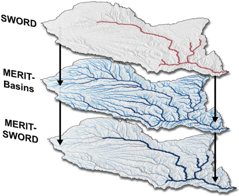
The recently launched Surface Water and Ocean Topography (SWOT) Mission is expected to provide transformative observations of water surface elevation, width, and slope and produce derived estimates of discharge for global rivers along rivers in the SWOT River Database (SWORD). However, the hydrographic representation of rivers in SWORD differs from hydrography data sets commonly used for modeling purposes, such as Multi‐Error‐Removed Improved Terrain (MERIT)‐Basins. Here, we develop links between the river networks of SWORD and MERIT‐Basins (MB) to enable interoperability between SWOT data products and hydrologic modeling frameworks. This data set, termed MERIT‐SWORD, identifies a subset of ∼277,000 global MB river reaches that most closely represent the location and extent of the SWORD river network and establishes bidirectional, one‐to‐many translations between reaches in the two hydrographic data sets. The MERIT‐SWORD data set serves to unite SWOT observations with river routing models, allowing for the seamless and standardized assimilation of SWOT vector products into global river simulations and the provision of improved a priori discharge estimates for SWOT discharge computation.
Overview
CoChat Summary
TL;DR
This paper presents MERIT-SWORD, a publicly available data product that links the SWOT River Database (SWORD) to MERIT-Basins (MB) through bidirectional, one-to-many translations between river reaches. It identifies ∼277,000 MB reaches corresponding to SWORD and provides diagnostics to support transferring SWOT observations into hydrologic models and model simulations into SWOT discharge workflows.
Key findings
- MERIT-SWORD identifies a subset of ∼277,000 global MB river reaches that best correspond to the SWORD river network and establishes bidirectional, one-to-many translations between reaches in the two hydrographic data sets.
- Globally, 9.1% (266,411) of all MB reaches were associated with a corresponding SWORD reach; each translated MB reach is on average associated with 1.69 SWORD reaches (minimum 0, maximum 40), and each SWORD reach corresponds on average to 2.05 MB reaches (minimum 0, maximum 11).
- Of the 277,036 global MB reaches in the MERIT-SWORD network, 266,444 (96.2%) have diagnostic flag “0,” confirming valid translations; of 241,852 SWORD reaches, 229,917 (95.1%) have flag “0.” The flow-accumulation mismatch flag “21” occurs for 5,937 (2.1%) MB-to-SWORD translations and 4,415 (1.8%) SWORD-to-MB translations.
- SWORD reaches classified as “river” (type 1) and “dam/waterfall” (type 4) have the most reliable translations, with 97.2% and 98.2% valid, respectively; “unreliable topology” reaches (type 5) are least reliable, with only 80.3% valid. The MERIT-SWORD network includes 277,036 MB reaches totaling 2,448,197 km, compared with 241,852 SWORD reaches totaling 2,172,425 km.
Methods
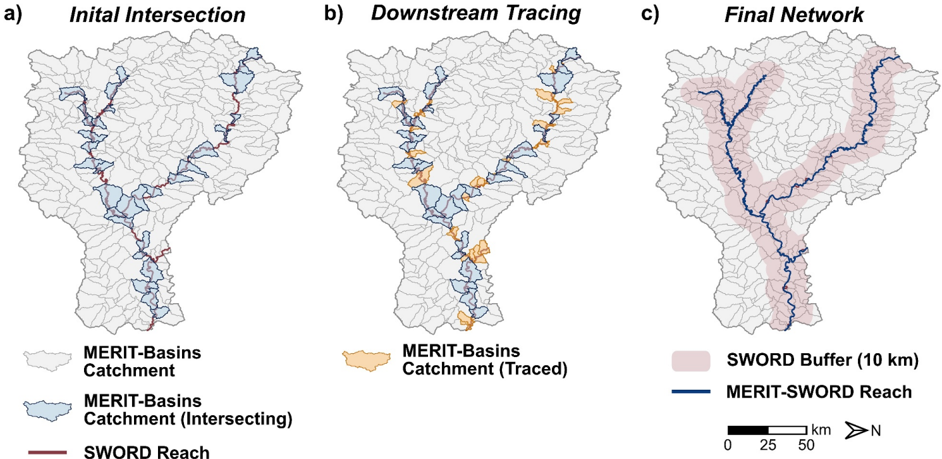
- The MERIT-SWORD river network was generated independently for each of 61 global Pfafstetter Level 2 hydrologic regions: each SWORD reach was intersected with MB catchments, the MB catchment containing the largest proportion of the SWORD reach was selected, selected reaches were traced downstream via MB’s NextDownID field to their outlet, MB reaches more than 10 km from the nearest SWORD reach were removed, and 3,583 erroneous MB reaches were removed.
- Translations were based on intersection of SWORD reaches with eligible MB unit catchments linked to MB reaches by shared COMID values; intersecting MB catchments were ranked by partial intersecting SWORD length, stored in columns such as mb_1, mb_2, sword_1, sword_2, and part_len_1, part_len_2. Flow accumulation values were compared to confirm similar reach size, and translations with flow accumulation values outside one order of magnitude were excluded.
- Diagnostic flags were assigned as “0” for valid translations, “1” for topological discontinuity, “2” for absent translation, “21” for translations removed due to flow-accumulation mismatch, and “22” for SWORD reaches outside the MB coastline. Validation checked that MB-to-SWORD translations could be recreated entirely from SWORD-to-MB translations and vice versa; demonstrations transferred MeanDRS discharge to SWORD and GRWL river widths to MB.
Limitations
- The paper states that removing reaches due to flow accumulation likely removes a limited number of valid translations because of anomalous flow accumulations in SWORD caused by network topology errors, and that this may improve with future SWORD topology updates.
- The paper states that MERIT-SWORD struggles in poorly drained, low-relief regions such as Northern Canada and Siberia, in multi-channel river systems and complex deltas, and for man-made diversions or canals; it advises caution for SWORD reaches flagged as unreliable topology (type 5).
- The paper states that boundary mismatches between MB and SWORD hydrologic regions can cause MB reaches assigned to a single SWORD region to originate from multiple MB regions and therefore not be topologically continuous in a small number of cases; it also notes the one-to-many approach differs from alternative one-to-one mapping methods.
- Evident from the text: the product is tied to specific versions (SWORD Version 16 and MB v1.0), so updates to either underlying data set would require an updated MERIT-SWORD product.
Model-written summary. Check it against the paper before relying on it.
Integrity signals
Registry
Cites
Statistics
Figures




Verification
Claims the paper makes
0 Valid · 2 Not valid · 22 Not checked · 64 Own results and interpretations
A result the paper states — it cites no source for it, so there is none to check. The quote shows it is in the paper.
In the paper
“The location and extent of rivers in SWORD differ considerably from other river network data sets that are commonly used for hydrological modeling such as Multi-Error-Removed Improved Terrain (MERIT)-Basins.”
- Also stated in: § 1. Introduction · plain
“The SWORD and MB river networks differ considerably in their representation of the location and extent of global river reaches, complicating potential synergistic data transfer between SWOT observations and existing hydrologic models.”
§ Bidirectional Translations Between Observational and Topography-Based Hydrographic Data Sets: MERIT-Basins and the SWOT River Database (SWORD) > Abstract
plain- Asserted: passes — The authors put it forward as true.
- Checkable: passes — It can be checked against evidence.
- Load-bearing: passes — The paper’s conclusions depend on it.
- Based: passes — The paper gives a reason why it holds.
- Also stated in: § 1. Introduction · plain
None of the sources cited for this claim have been checked yet.
In the paper
“Additionally, MERIT-SWORD struggles to represent SWORD reaches in multi-channel river systems and complex deltas.”
§ Bidirectional Translations Between Observational and Topography-Based Hydrographic Data Sets: MERIT-Basins and the SWOT River Database (SWORD) > 4.3. MERIT-Basins and SWORD Network Alignment
plainstates a cause- Asserted: passes — The authors put it forward as true.
- Checkable: passes — It can be checked against evidence.
- Load-bearing: passes — The paper’s conclusions depend on it.
- Based: passes — The paper gives a reason why it holds.
A result the paper reports from its own data — it cites no other source for it, so there is none to check. The quote shows it is in the paper.
In the paper
“First, we show how hydrologic simulations based on elevation-derived river networks such as MB can be seamlessly mapped onto the SWORD river network.”
§ Bidirectional Translations Between Observational and Topography-Based Hydrographic Data Sets: MERIT-Basins and the SWOT River Database (SWORD) > 5.1. Transferring Hydrologic Information Between MERIT-Basins and SWORD
plainstates an association- Asserted: passes — The authors put it forward as true.
- Checkable: passes — It can be checked against evidence.
- Load-bearing: passes — The paper’s conclusions depend on it.
- Based: passes — The paper gives a reason why it holds.
A result the paper states — it cites no source for it, so there is none to check. The quote shows it is in the paper.
In the paper
“Most commonly, SWORD reaches extend beyond the coastal endpoints of MB reaches and therefore lack counterparts in the MERIT-SWORD network.”
§ Bidirectional Translations Between Observational and Topography-Based Hydrographic Data Sets: MERIT-Basins and the SWOT River Database (SWORD) > 3.3. MERIT-SWORD Translation Diagnostics
plainstates a cause- Asserted: passes — The authors put it forward as true.
- Checkable: passes — It can be checked against evidence.
- Load-bearing: unclear — It is unclear whether the paper’s conclusions depend on it.
- Based: passes — The paper gives a reason why it holds.
A result the paper states — it cites no source for it, so there is none to check. The quote shows it is in the paper.
In the paper
“In some cases, often due to a misalignment between the hydrographic networks, some MB or SWORD reaches do not intersect any features in the other data set and are therefore not assigned a translation.”
§ Bidirectional Translations Between Observational and Topography-Based Hydrographic Data Sets: MERIT-Basins and the SWOT River Database (SWORD) > 3.3. MERIT-SWORD Translation Diagnostics
plainstates a possible cause- Asserted: passes — The authors put it forward as true.
- Checkable: passes — It can be checked against evidence.
- Load-bearing: unclear — It is unclear whether the paper’s conclusions depend on it.
- Based: passes — The paper gives a reason why it holds.
37 more claims
Create a free account to see all 88 claims and to verify the 34 references still open.
- It may state two separate claims as one. 26
- The quote only partly states this claim. 1
- Probably not a substantial claim. 24
Self-check
Percentages, sums and reported differences re-computed from the paper’s own numbers.
Each contradiction between two passages listed here was confirmed by an independent check.
Rated minor: it would not touch a result — a value no result rests on, a p-value that stays on the same side of the significance level, or a conflict that is clerical, resolved elsewhere in the paper, or outside its own findings.
In the paper
§ Bidirectional Translations Between Observational and Topography-Based Hydrographic Data Sets: MERIT-Basins and the SWOT River Database (SWORD) > 6. Conclusion
“Multi-Error-Removed Improved Terrain (MERIT)-SWOT river database (SWORD) reaches are translated to corresponding SWORD reaches (a, b) (and vice versa, from SWORD to MERIT-SWORD) (c, d)”
§ Bidirectional Translations Between Observational and Topography-Based Hydrographic Data Sets: MERIT-Basins and the SWOT River Database (SWORD) > 3.2. Translating Between MERIT-Basins and SWORD
“We provide translations from SWORD to MB by storing all SWORD reach_id values for a given region and relating those reaches to intersecting MB catchments, ranked by their corresponding partial SWORD lengths (Figure 3a).”
Rated minor: it would not touch a result — a value no result rests on, a p-value that stays on the same side of the significance level, or a conflict that is clerical, resolved elsewhere in the paper, or outside its own findings.
In the paper
§ Bidirectional Translations Between Observational and Topography-Based Hydrographic Data Sets: MERIT-Basins and the SWOT River Database (SWORD) > 4.2. MERIT-SWORD Translation Quality
“Of these MB reaches with translations, each reach is on average associated to 1.69 SWORD reaches, with a minimum of 0 and a maximum of 40 translated reaches.”
§ Bidirectional Translations Between Observational and Topography-Based Hydrographic Data Sets: MERIT-Basins and the SWOT River Database (SWORD) > 3.3. MERIT-SWORD Translation Diagnostics
“We assign reaches lacking corresponding translations with a diagnostic value of "2."”
Rated minor: it would not touch a result — a value no result rests on, a p-value that stays on the same side of the significance level, or a conflict that is clerical, resolved elsewhere in the paper, or outside its own findings.
In the paper
§ Bidirectional Translations Between Observational and Topography-Based Hydrographic Data Sets: MERIT-Basins and the SWOT River Database (SWORD) > Water Resources Research
“Of the 277,036 global MB reaches present in our MERIT-SWORD network, 266,444 (96.2%) have diagnostic flags equal to a value of "0," confirming that their translations are valid.”
§ Bidirectional Translations Between Observational and Topography-Based Hydrographic Data Sets: MERIT-Basins and the SWOT River Database (SWORD) > 4.2. MERIT-SWORD Translation Quality
“Globally, 9.1% (266,411) of all MB reaches were associated to a corresponding SWORD reach.”
Rated minor: it would not touch a result — a value no result rests on, a p-value that stays on the same side of the significance level, or a conflict that is clerical, resolved elsewhere in the paper, or outside its own findings.
In the paper
§ Bidirectional Translations Between Observational and Topography-Based Hydrographic Data Sets: MERIT-Basins and the SWOT River Database (SWORD) > 6. Conclusion
“For a given MB reach B and its associated catchment, the reach IDs of intersecting SWORD reaches α and β are ordered by the partial length of SWORD α and β (in km) contained within catchment B.”
§ Bidirectional Translations Between Observational and Topography-Based Hydrographic Data Sets: MERIT-Basins and the SWOT River Database (SWORD) > 3.2. Translating Between MERIT-Basins and SWORD
“while the partial SWORD lengths (m) are again stored in columns named part_len_1, part_len_2,…, etc (Figure 3d).”
Citations
Cites
The Shuttle Radar Topography Mission
Farr, T. G., Rosen, P. A., Caro, E., Crippen, R., Duren, R., Hensley, S., Kobrick, M., Paller, M., Rodriguez, E., Roth, L., et al. (2007) · Reviews of Geophysics · doi:10.1029/2005rg000183 · Cited by 8,927
New Global Hydrography Derived from Spaceborne Elevation Data
Lehner, B., Verdin, K., & Jarvis, A. (2008) · Eos, Transactions American Geophysical Union · doi:10.1029/2008eo100001 · Cited by 2,411
Lehner, B., & Grill, G. (2013) · Hydrological Processes · doi:10.1002/hyp.9740 · Cited by 2,193
MERIT Hydro: A High‐Resolution Global Hydrography Map Based on Latest Topography Dataset
Yamazaki, D., Ikeshima, D., Sosa, J., Bates, P. D., Allen, G. H., & Pavelsky, T. M. (2019) · Water Resources Research · doi:10.1029/2019wr024873 · Cited by 1,392
Self-citationA High-Accuracy Map of Global Terrain Elevations
Yamazaki, D., Ikeshima, D., Tawatari, R., Yamaguchi, T., O'Loughlin, F., Neal, J. C., Sampson, C. C., Kanae, S., & Bates, P. D. (2017) · Geophysical Research Letters · doi:10.1002/2017gl072874 · Cited by 1,326
Measuring surface water from space
Alsdorf, D. E., Rodríguez, E., & Lettenmaier, D. P. (2007) · Reviews of Geophysics · doi:10.1029/2006rg000197 · Cited by 1,027
Global extent of rivers and streams
Allen, G. H., & Pavelsky, T. M. (2018) · Science · doi:10.1126/science.aat0636 · Cited by 970
Self-citationGlobal Reconstruction of Naturalized River Flows at 2.94 Million Reaches
Lin, P., Pan, M., Beck, H. E., Yang, Y., Yamazaki, D., Frasson, R., David, C. H., Durand, M., Pavelsky, T. M., Allen, G. H., et al. (2019) · Water Resources Research · doi:10.1029/2019wr025287 · Cited by 511
Self-citationThe SWOT Mission and Its Capabilities for Land Hydrology
Biancamaria, S., Lettenmaier, D. P., & Pavelsky, T. M. (2016) · Surveys in Geophysics · doi:10.1007/s10712-015-9346-y · Cited by 458
Self-citationA topological system for delineation and codification of the Earth’s river basins
Verdin, K. L., & Verdin, J. P. (1999) · Journal of Hydrology · doi:10.1016/s0022-1694(99)00011-6 · Cited by 325
Altenau, E. H., Pavelsky, T. M., Durand, M. T., Yang, X., Frasson, R. P. D. M., & Bendezu, L. (2021) · Water Resources Research · doi:10.1029/2021wr030054 · Cited by 317
Self-citationRecent changes to Arctic river discharge
Feng, D., Gleason, C. J., Lin, P., Yang, X., Pan, M., & Ishitsuka, Y. (2021) · Nature Communications · doi:10.1038/s41467-021-27228-1 · Cited by 234
Durand, M., Gleason, C. J., Pavelsky, T. M., Prata de Moraes Frasson, R., Turmon, M., David, C. H., Altenau, E. H., Tebaldi, N., Larnier, K., Monnier, J., et al. (2023) · Water Resources Research · doi:10.1029/2021wr031614 · Cited by 184
Self-citationNOAA's National Water Model: Advancing operational hydrology through continental‐scale modeling
Cosgrove, B., Gochis, D., Flowers, T., Dugger, A., Ogden, F., Graziano, T., Clark, E., Cabell, R., Casiday, N., Cui, Z., et al. (2024) · JAWRA Journal of the American Water Resources Association · doi:10.1111/1752-1688.13184 · Cited by 127
Oubanas, H., Gejadze, I., Malaterre, P. ‐., Durand, M., Wei, R., Frasson, R. P. M., & Domeneghetti, A. (2018) · Water Resources Research · doi:10.1002/2017wr021735 · Cited by 114
Self-citationOubanas, H., Gejadze, I. Y., Malaterre, P., & Mercier, F. (2018) · Journal of Hydrology · doi:10.1016/j.jhydrol.2018.02.004 · Cited by 96
Self-citationGlobal Reach-Level 3-Hourly River Flood Reanalysis (1980–2019)
Yang, Y., Pan, M., Lin, P., Beck, H. E., Zeng, Z., Yamazaki, D., David, C. H., Lu, H., Yang, K., Hong, Y., et al. (2021) · Bulletin of the American Meteorological Society · doi:10.1175/bams-d-20-0057.1 · Cited by 91
Self-citationKaRIn, the Ka-Band Radar Interferometer of the SWOT Mission: Design and in-Flight Performance
Peral, E., Esteban-Fernández, D., Rodríguez, E., McWatters, D., De Bleser, J.-W., Ahmed, R., Chen, A. C., Slimko, E., Somawardhana, R., Knarr, K., et al. (2024) · IEEE Transactions on Geoscience and Remote Sensing · doi:10.1109/tgrs.2024.3405343 · Cited by 76
How Have Global River Widths Changed Over Time?
Feng, D., Gleason, C. J., Yang, X., Allen, G. H., & Pavelsky, T. M. (2022) · Water Resources Research · doi:10.1029/2021wr031712 · Cited by 70
Self-citationGlobal patterns in river water storage dependent on residence time
Collins, E. L., David, C. H., Riggs, R., Allen, G. H., Pavelsky, T. M., Lin, P., Pan, M., Yamazaki, D., Meentemeyer, R. K., & Sanchez, G. M. (2024) · Nature Geoscience · doi:10.1038/s41561-024-01421-5 · Cited by 46
Self-citationYin, Z., Lin, P., Riggs, R., Allen, G. H., Lei, X., Zheng, Z., & Cai, S. (2024) · Earth system science data · doi:10.5194/essd-16-1559-2024 · Cited by 33
A Participatory Science Approach to Expanding Instream Infrastructure Inventories
Whittemore, A., Ross, M. R. V., Dolan, W., Langhorst, T., Yang, X., Pawar, S., Jorissen, M., Lawton, E., Januchowski‐Hartley, S., & Pavelsky, T. (2020) · Earth's Future · doi:10.1029/2020ef001558 · Cited by 29
Self-citationAn Assessment of a Ka-Band Radar Interferometer Mission Accuracy Over Eurasian Rivers
Enjolras, V. M., & Rodriguez, E. (2009) · IEEE Transactions on Geoscience and Remote Sensing · doi:10.1109/tgrs.2008.2006370 · Cited by 16
HarP: Harmonized Prior river-lake database
Sikder, M. S., Wang, J., Allen, G. H., Sheng, Y., Yamazaki, D., Crétaux, J., & Pavelsky, T. M. (2024) · Zenodo (CERN European Organization for Nuclear Research) · doi:10.5281/zenodo.14205130 · Cited by 6
Self-citationMERIT-SWORD: Bidirectional Translations Between MERIT-Basins and the SWOT River Database (SWORD)
Wade, J., David, C. H., Altenau, E. H., Collins, E. L., Oubanas, H., Coss, S., Cerbelaud, A., Tom, M., Durand, M., & Pavelsky, T. M. (2024) · Zenodo (CERN European Organization for Nuclear Research) · doi:10.5281/zenodo.13152825 · Cited by 5
Self-citationHarP: Harmonized Prior river-lake database
Sikder, M. S., Wang, J., Allen, G. H., Sheng, Y., Yamazaki, D., Crétaux, J.-F., & Pavelsky, T. M. (2024) · Zenodo · doi:10.5281/zenodo.14205131
Self-citationMERIT-SWORD: Bidirectional Translations Between MERIT-Basins and the SWOT River Database (SWORD)
Wade, J., David, C. H., Altenau, E., Collins, E., Oubanas, H., Coss, S., Cerbelaud, A., Tom, M., Durand, M., & Pavelsky, T. (2025) · Zenodo · doi:10.5281/zenodo.14675925
Self-citationAdams, A., Almarzouq, B., Lacerda, M. A., Alwood, J., Alzahawi, S., Azevedo, F., Barry, R. K., Batalha, N., Bayer, J. M. M., Bell, T., et al. (2023) · Zenodo · doi:10.5281/zenodo.10161527
Self-citation
Research works printed but not linked: 1
- JPL Internal Document, 2018, Surface water and ocean topography mission project science requirements document
Cited by
Satellite Requirements to Capture Water Propagation in Earth's Rivers
Cerbelaud, A., David, C. H., Pavelsky, T., Biancamaria, S., Garambois, P. ‐., Kittel, C., Papa, F., Bates, P., Tourian, M. J., Durand, M., et al. (2025) · Reviews of Geophysics · doi:10.1029/2024rg000871 · Cited by 25
Self-citationWide-swath altimetry maps bank shapes and storage changes in global rivers
Cerbelaud, A., Wade, J., David, C. H., Durand, M. T., Frasson, R. P. D. M., Pavelsky, T. M., & Oubanas, H. (2026) · Nature · doi:10.1038/s41586-026-10218-y · Cited by 20
Self-citationChen, Y., Cohen, S., Baruah, A., Devi, D., Dhital, S., Tian, D., & Munasinghe, D. (2025) · Scientific Data · doi:10.1038/s41597-025-05941-6 · Cited by 8
River Network Routing and Discharge Partitioning on a Multichannel River Network
Collins, E. L., Altenau, E. H., Pavelsky, T. M., David, C. H., Getirana, A., & Johnson, E. (2025) · Water Resources Research · doi:10.1029/2025wr041417 · Cited by 7
Self-citationVerma, K., & Munier, S. (2026) · Geoscientific model development · doi:10.5194/gmd-19-10887-2026
Metadata
- Authors
- Wade, J., David, C. H., Altenau, E. H., Collins, E. L., Oubanas, H., Coss, S., Cerbelaud, A., Tom, M., Durand, M., & Pavelsky, T. M.
- Affiliations
- Jet Propulsion Laboratory (US)
- University of North Carolina at Chapel Hill (US)
- Institut National de Recherche pour l'Agriculture, l'Alimentation et l'Environnement (FR)
- Byrd Polar and Climate Research Center (US)
- Corresponding author
- Wade, Jeffrey
- ORCID
- Venue
- Water Resources Research
- Publisher
- American Geophysical Union (AGU)
- Published
- 2025-05
- Volume
- 61
- Issue
- 5
- Pages
- e2024WR038633
- ISSN
- 0043-1397 (ISSN-L)
- 1944-7973
- OpenAlex
- W4410705207
- Cited by
- 8
- References
- 25
- Citations by year
- 2026: 5 · 2025: 3
- FWCI
- 1.63
- Type
- journal article
- Language
- en
- Open access
- gold
- doi.org
- Licence
- Locations
- Water Resources Research (publishedVersion, cc-by)
- HAL (submittedVersion, cc-by)
- DOAJ (DOAJ: Directory of Open Access Journals) (submittedVersion, cc-by-sa)
- Funders
- National Aeronautics and Space Administration
- Topics
- Physical Sciences › Environmental Science › Water Science and Technology › Hydrology and Watershed Management Studies
- Physical Sciences › Environmental Science › Global and Planetary Change › Flood Risk Assessment and Management
- Physical Sciences › Environmental Science › Environmental Engineering › Soil Moisture and Remote Sensing
- Keywords
- SWOT mission, river network mapping, river discharge estimation, water level, river routing
About these checks
Registry, retraction, Cites and statistics results are computed, not judged, with one exception: a printed reference that no index lists is read once by a model before it counts as a citation error. Claims are extracted by a model and kept only when their quote appears verbatim in the text; each cited source is then checked, with a model’s help, for whether it says what the claim relies on. Those verdicts can be wrong — read the claim’s quote and the cited source before relying on one.
A language model drew the claims from the paper on 2026-11-18, under version 3 of the claim definition (model deepseek-v4.1-flash, prompt extract-v3).
A second model labelled each claim on 2026-11-18 (model jev-1.13-20260917, definition revision gold-guideline-v0.2).
Statistics and arithmetic are recomputed, not judged.
Confidence bands are shown only for fields calibrated on our annotated test set. None is calibrated yet, so no band is shown.
What counts as a claim ›How we measure confidence ›How we check this ›
Are you an author, or do you see a problem with this page? Request a review
Data sources
Bibliographic data: Semantic Scholar, OpenAlex, Crossref.
Contains information from the Semantic Scholar Academic Graph Datasets, made available under the ODC Attribution License (ODC-BY 1.0).
Semantic Scholar’s data is described in: Kinney, R., et al. (2023). The Semantic Scholar Open Data Platform. arXiv:2301.10140.
