

The DOI matches its Crossref record; 58 of the 58 references it cites were found in a registry or an index.
Spatially-informed interpolation for reconstructing lake area time series using semantic neighborhood correlation
Open accessPublished version of a preprint
Abstract
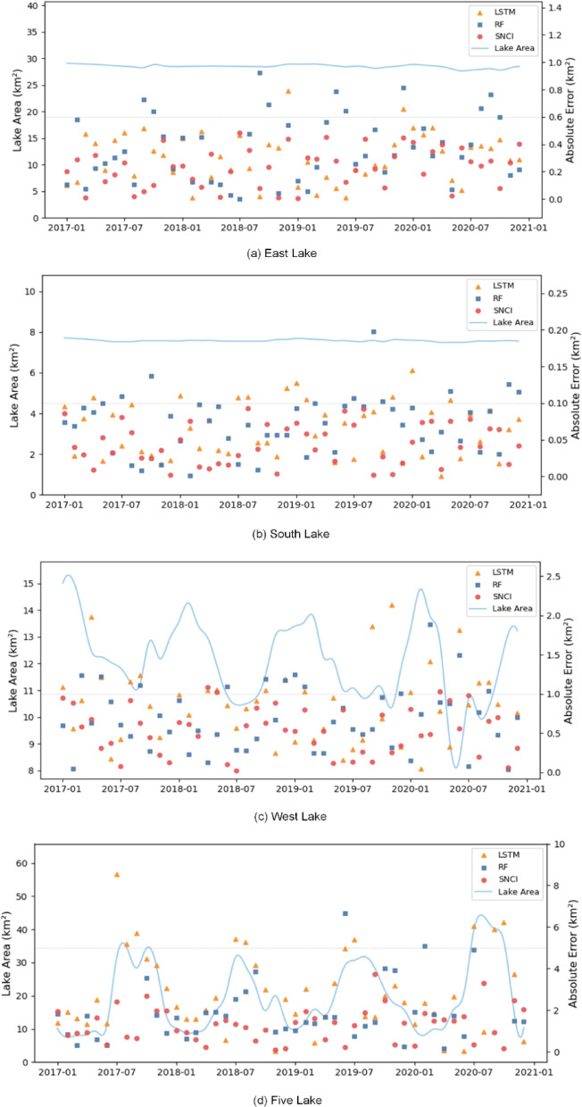
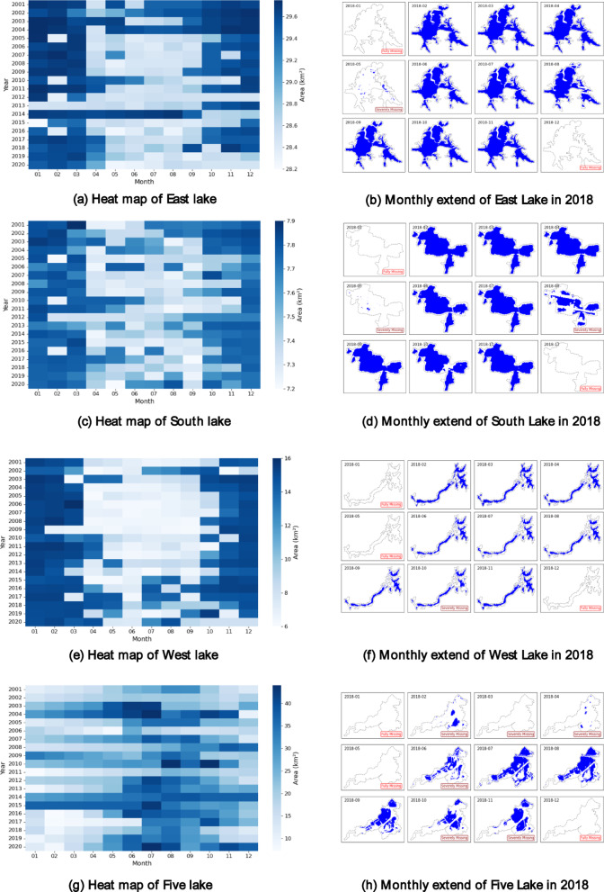
Long-term, high-resolution records of lake surface area are essential for characterizing the spatiotemporal dynamics of inland water bodies. Although Synthetic Aperture Radar has substantially improved water extent detection under adverse conditions, optical remote sensing imagery remains the dominant data source owing to its higher spatial resolution. Nevertheless, optical data are frequently compromised by persistent cloud cover and sensor limitations, leading to substantial observational gaps. To effectively address this challenge, this study introduces a novel spatially-informed interpolation method termed Semantic Neighborhood Correlation-based Interpolation (SNCI), which leverages spatial correlations among hydrologically interconnected lakes to reconstruct missing lake area observations. By explicitly modeling the inherent hydrological and climatic coherence among neighboring lakes, SNCI provides robust, accurate, and scalable interpolations even in the presence of extensive temporal data losses. The method was evaluated on monthly lake area data from 54 lakes in the Wuhan region between 2000 and 2020, using the Global Surface Water dataset, and validated against high-resolution Dynamic World observations. Several representative lakes were analyzed in detail to assess SNCI’s robustness across diverse seasonal and interannual conditions. Compared with polynomial fitting, Random Forest, and Long Short-Term Memory, SNCI consistently achieves lower interpolation errors. In the case of East Lake, SNCI reduces mean absolute error by 50.1% and root mean square error by 28.3% relative to the best-performing baseline. Across all lakes, SNCI demonstrates superior accuracy and correlation, particularly under data-sparse conditions. These results underscore SNCI’s potential to enhance lake area reconstruction accuracy and support broader applications in hydrological modeling, environmental monitoring, and climate impact assessment.
Overview
The claims and statistics of this paper haven’t been checked yet.
Run the check — free, no account needed. It reads the open-access text and checks the sources it cites.
Integrity signals
Registry
Cites
Statistics
Figures
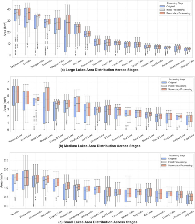
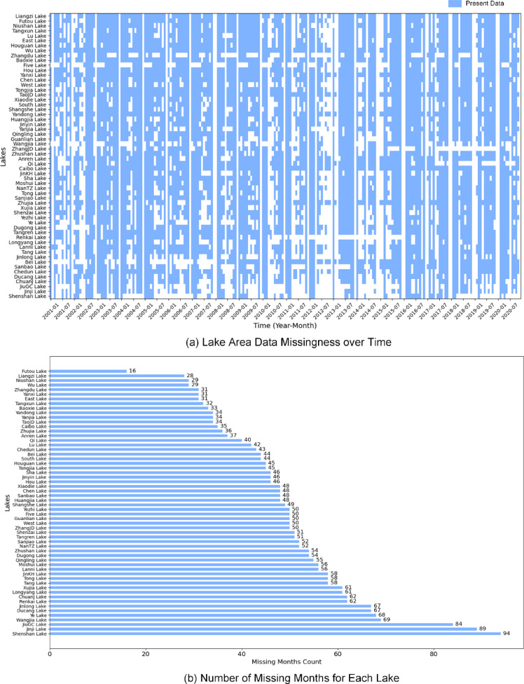
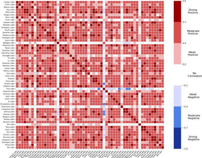
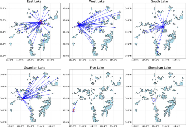
Verification
Claims the paper makes
The claims and statistics of this paper haven’t been checked yet.
Run the check — free, no account needed. It reads the open-access text and checks the sources it cites.
Self-check
Percentages, sums and reported differences re-computed from the paper’s own numbers.
The self-check needs the paper’s full text.
Citations
Cites
Google Earth Engine: Planetary-scale geospatial analysis for everyone
Gorelick, N., Hancher, M., Dixon, M., Ilyushchenko, S., Thau, D., & Moore, R. (2017) · Remote Sensing of Environment · doi:10.1016/j.rse.2017.06.031 · Cited by 14,719
A Comprehensive Survey on Graph Neural Networks
Wu, Z., Pan, S., Chen, F., Long, G., Zhang, C., & Yu, P. S. (2021) · IEEE Transactions on Neural Networks and Learning Systems · doi:10.1109/tnnls.2020.2978386 · Cited by 11,000
Ecological and Evolutionary Responses to Recent Climate Change
Parmesan, C. (2006) · Annual Review of Ecology, Evolution, and Systematics · doi:10.1146/annurev.ecolsys.37.091305.110100 · Cited by 8,652
Greff, K., Srivastava, R. K., Koutnik, J., Steunebrink, B. R., & Schmidhuber, J. (2017) · IEEE Transactions on Neural Networks and Learning Systems · doi:10.1109/tnnls.2016.2582924 · Cited by 6,955
High-resolution mapping of global surface water and its long-term changes
Pekel, J.-F., Cottam, A., Gorelick, N., & Belward, A. S. (2016) · Nature · doi:10.1038/nature20584 · Cited by 5,513
Pearson Correlation Coefficient
Benesty, J., Chen, J., Huang, Y. A., & Cohen, I. (2009) · Springer topics in signal processing · doi:10.1007/978-3-642-00296-0_5 · Cited by 3,540
A Comprehensive Survey on Graph Neural Networks
Wu, Z., Pan, S., Chen, F., Long, G., Zhang, C., & Yu, P. (2020) · UTS ePRESS (University of Technology Sydney) · Cited by 3,174
Ground water and climate change
Taylor, R. G., Scanlon, B. R., Döll, P., Rodell, M., van Beek, R., Wada, Y., Longuevergne, L., Leblanc, M. J., Famiglietti, J. S., Edmunds, M., et al. (2012) · Nature Climate Change · doi:10.1038/nclimate1744 · Cited by 2,786
Kriging: a method of interpolation for geographical information systems
Oliver, M. A., & Webster, R. (1990) · International Journal of Geographical Information Systems · doi:10.1080/02693799008941549 · Cited by 2,275
Temporal Convolutional Networks for Action Segmentation and Detection
Lea, C., Flynn, M. D., Vidal, R., Reiter, A., & Hager, G. D. (2017) · 2017 IEEE Conference on Computer Vision and Pattern Recognition (CVPR) · doi:10.1109/cvpr.2017.113 · Cited by 2,238
An adaptive inverse-distance weighting spatial interpolation technique
Lu, G. Y., & Wong, D. W. (2008) · Computers & Geosciences · doi:10.1016/j.cageo.2007.07.010 · Cited by 1,570
Google Earth Engine for geo-big data applications: A meta-analysis and systematic review
Tamiminia, H., Salehi, B., Mahdianpari, M., Quackenbush, L., Adeli, S., & Brisco, B. (2020) · ISPRS Journal of Photogrammetry and Remote Sensing · doi:10.1016/j.isprsjprs.2020.04.001 · Cited by 1,363
Dynamic world, near real-time global 10 m land use land cover mapping
Brown, C. F., Brumby, S. P., Guzder-Williams, B., Birch, T., Hyde, S. B., Mazzariello, J., Czerwinski, W., Pasquarella, V. J., Haertel, R., Ilyushchenko, S., et al. (2022) · Scientific Data · doi:10.1038/s41597-022-01307-4 · Cited by 1,154
Sentinel-2 Data for Land Cover/Use Mapping: A Review
Phiri, D., Simwanda, M., Salekin, S., Nyirenda, V. R., Murayama, Y., & Ranagalage, M. (2020) · Remote Sensing · doi:10.3390/rs12142291 · Cited by 1,147
A Global Assessment of the SRTM Performance
Rodríguez, E., Morris, C. S., & Belz, J. E. (2006) · Photogrammetric Engineering & Remote Sensing · doi:10.14358/pers.72.3.249 · Cited by 1,106
Tobler's First Law and Spatial Analysis
Miller, H. J. (2004) · Annals of the Association of American Geographers · doi:10.1111/j.1467-8306.2004.09402005.x · Cited by 941
Spatial Interpolation Methods: A Review
Lam, N. S.-N. (1983) · The American Cartographer · doi:10.1559/152304083783914958 · Cited by 940
Crétaux, J.-F., Arsen, A., Calmant, S., Kouraev, A., Vuglinski, V., Bergé-Nguyen, M., Gennero, M.-C., Nino, F., Abarca Del Rio, R., Cazenave, A., et al. (2011) · Advances in Space Research · doi:10.1016/j.asr.2011.01.004 · Cited by 751
South-to-North Water Diversion stabilizing Beijing’s groundwater levels
Long, D., Yang, W., Scanlon, B. R., Zhao, J., Liu, D., Burek, P., Pan, Y., You, L., & Wada, Y. (2020) · Nature Communications · doi:10.1038/s41467-020-17428-6 · Cited by 598
DeVries, B., Huang, C., Armston, J., Huang, W., Jones, J. W., & Lang, M. W. (2020) · Remote Sensing of Environment · doi:10.1016/j.rse.2020.111664 · Cited by 518
Zhang, G., Yao, T., Xie, H., et al. (2015) · Global and Planetary Change · doi:10.1016/j.gloplacha.2015.05.013 · Cited by 505
Mapping global lake dynamics reveals the emerging roles of small lakes
Pi, X., Luo, Q., Feng, L., Xu, Y., Tang, J., Liang, X., Ma, E., Cheng, R., Fensholt, R., Brandt, M., et al. (2022) · Nature Communications · doi:10.1038/s41467-022-33239-3 · Cited by 422
Climate change threatens terrestrial water storage over the Tibetan Plateau
Li, X., Long, D., Scanlon, B. R., Mann, M. E., Li, X., Tian, F., Sun, Z., & Wang, G. (2022) · Nature Climate Change · doi:10.1038/s41558-022-01443-0 · Cited by 388
A half‐century of changes in China's lakes: Global warming or human influence?
Rong-hua, M., Duan, H., Hu, C., Feng, X., Li, A., Ju, W., Jiang, J., & Yang, G. (2010) · Geophysical Research Letters · doi:10.1029/2010gl045514 · Cited by 373
A simple more general boxplot method for identifying outliers
Schwertman, N. C., Owens, M. A., & Adnan, R. (2003) · Computational Statistics & Data Analysis · doi:10.1016/j.csda.2003.10.012 · Cited by 370
(2019) · neural information processing systems · Cited by 350
A Review of Local Outlier Factor Algorithms for Outlier Detection in Big Data Streams
Alghushairy, O., Alsini, R., Soule, T., & Ma, X. (2020) · Big Data and Cognitive Computing · doi:10.3390/bdcc5010001 · Cited by 345
Li, Z., He, W., Cheng, M., Hu, J., Yang, G., & Zhang, H. (2023) · Earth System Science Data · doi:10.5194/essd-15-4749-2023 · Cited by 306
Geographically Weighted Regression
Fotheringham, A. S. (2009) · SAGE Publications Ltd eBooks · doi:10.4135/9780857020130.n13 · Cited by 305
Multilevel Cloud Detection in Remote Sensing Images Based on Deep Learning
Xie, F., Shi, M., Shi, Z., Yin, J., & Zhao, D. (2017) · IEEE Journal of Selected Topics in Applied Earth Observations and Remote Sensing · doi:10.1109/jstars.2017.2686488 · Cited by 288
Proceedings of the 3rd International Conference on Knowledge Discovery and Data Mining
Heckerman, D. E., Uthurusamy, R., Mannila, H., & Pregibon, D. (1997) · AAAI Press eBooks · Cited by 271
Toward continental hydrologic–hydrodynamic modeling in South America
Siqueira, V. A., de Paiva, R. C. D., Fleischmann, A. S., Fan, F. M., Ruhoff, A., Pontes, P. R. M., Paris, A., Calmant, S., & Collischonn, W. (2018) · Hydrology and earth system sciences · doi:10.5194/hess-22-4815-2018 · Cited by 226
iForest: Interpreting Random Forests via Visual Analytics
Zhao, X., Wu, Y., Lee, D. L., & Cui, W. (2018) · IEEE Transactions on Visualization and Computer Graphics · doi:10.1109/tvcg.2018.2864475 · Cited by 217
Automatic High Frequency Monitoring for Improved Lake and Reservoir Management
Marcé, R., George, G., Buscarinu, P., Deidda, M., Dunalska, J., de Eyto, E., Flaim, G. M., Grossart, H., Istvánovics, V., Lenhardt, M. B., et al. (2016) · Environmental Science & Technology · doi:10.1021/acs.est.6b01604 · Cited by 204
Spatial impact of urban expansion on surface water bodies—A case study of Wuhan, China
Du, N., Ottens, H. F. L., & Sliuzas, R. (2009) · Landscape and Urban Planning · doi:10.1016/j.landurbplan.2009.10.002 · Cited by 199
Song, C., Huang, B., Ke, L., & Richards, K. (2014) · ISPRS Journal of Photogrammetry and Remote Sensing · doi:10.1016/j.isprsjprs.2014.03.001 · Cited by 199
Efficient perovskite/silicon tandem with asymmetric self-assembly molecule
Jia, L., Xia, S., Li, J., Qin, Y., Pei, B., Ding, L., Yin, J. L., Du, T., Fang, Z., Yin, Y., et al. (2025) · Nature · doi:10.1038/s41586-025-09333-z · Cited by 196
Self-citationYang, R., Zhu, L., Wang, J., Ju, J., Ma, Q., Turner, F., & Guo, Y. (2016) · Climatic Change · doi:10.1007/s10584-016-1877-9 · Cited by 151
Monitoring small reservoirs' storage with satellite remote sensing in inaccessible areas
Avisse, N., Tilmant, A., Müller, M. F., & Zhang, H. (2017) · Hydrology and earth system sciences · doi:10.5194/hess-21-6445-2017 · Cited by 140
A taxonomic, genetic and ecological data resource for the vascular plants of Britain and Ireland
Henniges, M. C., Powell, R. F., Mian, S., Stace, C. A., Walker, K. J., Gornall, R. J., Christenhusz, M. J. M., Brown, M. R., Twyford, A. D., Hollingsworth, P. M., et al. (2022) · Scientific Data · doi:10.1038/s41597-021-01104-5 · Cited by 123
A Review of Optical and SAR Image Deep Feature Fusion in Semantic Segmentation
Liu, C., Sun, Y., Xu, Y., Sun, Z., Zhang, X., Lei, L., & Kuang, G. (2024) · IEEE Journal of Selected Topics in Applied Earth Observations and Remote Sensing · doi:10.1109/jstars.2024.3424831 · Cited by 116
Self-citationGlobal dominance of seasonality in shaping lake-surface-extent dynamics
Li, L., Long, D., Wang, Y., & Woolway, R. I. (2025) · Nature · doi:10.1038/s41586-025-09046-3 · Cited by 108
Bioresita, F., Puissant, A., Stumpf, A., & Malet, J. (2019) · International Journal of Remote Sensing · doi:10.1080/01431161.2019.1624869 · Cited by 88
Li, X., Ling, F., Foody, G. M., Boyd, D. S., Jiang, L., Zhang, Y., Zhou, P., Wang, Y., Chen, R., & Du, Y. (2021) · Remote Sensing of Environment · doi:10.1016/j.rse.2021.112680 · Cited by 84
Improved maps of surface water bodies, large dams, reservoirs, and lakes in China
Wang, X., Xiao, X., Qin, Y., Dong, J., Wu, J., & Li, B. (2022) · Earth system science data · doi:10.5194/essd-14-3757-2022 · Cited by 82
Environmental issues of Lake Taihu, China
Qin, B., Xu, P., Wu, Q. L., Luo, L., & Zhang, Y. (2007) · Springer eBooks · doi:10.1007/978-1-4020-6158-5_2 · Cited by 62
A Geographer Looks at Spatial Information Theory
Goodchild, M. F. (2001) · Lecture notes in computer science · doi:10.1007/3-540-45424-1_1 · Cited by 55
Li, J., Li, L., Song, Y., Chen, J., Wang, Z., Bao, Y., Zhang, W., & Meng, L. (2023) · International Journal of Applied Earth Observation and Geoinformation · doi:10.1016/j.jag.2023.103288 · Cited by 53
Malekian, A., & Kazemzadeh, M. (2015) · Water Resources Management · doi:10.1007/s11269-015-1190-9 · Cited by 36
Inland Water Body Mapping Using Multitemporal Sentinel-1 SAR Data
Marzi, D., & Gamba, P. E. (2021) · IEEE Journal of Selected Topics in Applied Earth Observations and Remote Sensing · doi:10.1109/jstars.2021.3127748 · Cited by 31
Yang, B., & Ke, X. (2015) · Physics and Chemistry of the Earth Parts A/B/C · doi:10.1016/j.pce.2015.10.005 · Cited by 24
Sentinel-1 and Sentinel-2 data fusion system for surface water extraction
Saghafi, M., Ahmadi, A., & Bigdeli, B. (2021) · Journal of Applied Remote Sensing · doi:10.1117/1.jrs.15.014521 · Cited by 23
Jing, Y., Fei, Z., & Wang, X. (2017) · European Journal of Remote Sensing · doi:10.1080/22797254.2017.1413955 · Cited by 20
Martinsen, K. T., & Sand‐Jensen, K. (2022) · The Science of The Total Environment · doi:10.1016/j.scitotenv.2022.158090 · Cited by 13
Ding, M., Wang, J., Song, C., Sheng, Y., Hutchinson, J. M. S., Langston, A. L., & Marston, L. T. (2023) · Journal of Hydrology · doi:10.1016/j.jhydrol.2024.130704 · Cited by 10
Contrasting lake changes in Tibet revealed by recent multi-modal satellite observations
Ran, J., Liu, L., Zhang, G., Shum, C. K., Qiu, J., Hu, R., Li, J., Peng, J., Hwang, C., Luan, Y., et al. (2023) · The Science of The Total Environment · doi:10.1016/j.scitotenv.2023.168342 · Cited by 8
Li, W., Yao, Z., Pan, X., Wei, Z., Jiang, B., Wang, J., Xu, M., & Cui, Y. (2023) · Journal of Hydrology · doi:10.1016/j.jhydrol.2024.130888 · Cited by 8
Zeng, H., Yu, F., Hu, H., Han, Y. Y., Ye, R., & Cao, C. (2025) · Scientific Reports · doi:10.1038/s41598-025-88314-8 · Cited by 3
Metadata
- Authors
- Liu, C.
- Affiliations
- Wuhan University (CN)
- Corresponding author
- Liu, Chen
- ORCID
- Liu, Chen
- Venue
- Scientific Reports
- Published
- 2025-07-09
- Volume
- 15
- Issue
- 1
- Pages
- 24787-24787
- ISSN
- 2045-2322 (ISSN-L)
- PMC
- PMC12241530
- OpenAlex
- W4412177594
- Cited by
- 1
- References
- 58
- Citations by year
- 2026: 1
- FWCI
- 0.25
- Type
- journal article
- Language
- en
- Open access
- gold
- doi.org
- Licence
- cc-by
- creativecommons.org/licenses/by/4.0 (tdm)
- creativecommons.org/licenses/by/4.0 (vor)
- Locations
- Scientific Reports (publishedVersion, cc-by)
- Research Square (acceptedVersion, cc-by)
- Europe PMC (PubMed Central) (publishedVersion, cc-by)
- PubMed Central (publishedVersion, cc-by)
- PubMed (publishedVersion)
- DOAJ (DOAJ: Directory of Open Access Journals) (submittedVersion, cc-by-sa)
- Topics
- Physical Sciences › Environmental Science › Water Science and Technology › Hydrology and Watershed Management Studies
- Physical Sciences › Environmental Science › Environmental Engineering › Hydrological Forecasting Using AI
- Physical Sciences › Environmental Science › Management, Monitoring, Policy and Law › Environmental Monitoring and Data Management
- Keywords
- missing data interpolation, surface water extent, Global Surface Water dataset, Dynamic World, East Lake
About these checks
Registry, retraction, Cites and statistics results are computed, not judged, with one exception: a printed reference that no index lists is read once by a model before it counts as a citation error. Claims are extracted by a model and kept only when their quote appears verbatim in the text; each cited source is then checked, with a model’s help, for whether it says what the claim relies on. Those verdicts can be wrong — read the claim’s quote and the cited source before relying on one.
Statistics and arithmetic are recomputed, not judged.
Confidence bands are shown only for fields calibrated on our annotated test set. None is calibrated yet, so no band is shown.
What counts as a claim ›How we measure confidence ›How we check this ›
Are you an author, or do you see a problem with this page? Request a review
Data sources
Bibliographic data: Semantic Scholar, OpenAlex, Crossref.
Contains information from the Semantic Scholar Academic Graph Datasets, made available under the ODC Attribution License (ODC-BY 1.0).
Semantic Scholar’s data is described in: Kinney, R., et al. (2023). The Semantic Scholar Open Data Platform. arXiv:2301.10140.
