

The DOI matches its Crossref record; 43 of the 43 references it cites were found in a registry or an index; 12 of the 30 sources its claims cite were checked for support.
Cognitive Maps for a Non-Euclidean Environment: Path Integration and Spatial Memory on a Sphere
Open accessAbstract
Humans build mental models of the world and utilize them for various cognitive tasks. The exact form of cognitive maps is not fully understood, especially for novel and complex environments beyond the flat Euclidean environment. To address this gap, we investigated path integration —a critical process underlying cognitive mapping—and spatial-memory capacity on the spherical (non-Euclidean) and planar (Euclidean) environments in young healthy adults ( N = 20) using immersive virtual reality. We observed a strong Euclidean bias during the path-integration task on the spherical surface, even among participants who possessed knowledge of non-Euclidean geometry. Notably, despite this bias, participants demonstrated reasonable navigation ability on the sphere. This observation and simulation suggest that humans navigate nonflat surfaces by constructing locally confined Euclidean maps and flexibly combining them. This insight sheds light on potential neural mechanisms and behavioral strategies for solving complex cognitive tasks.
Overview
CoChat Summary
TL;DR
In a preregistered immersive-VR study, 20 healthy young adults navigated matched spherical and planar environments, and their path integration on the sphere was strongly better explained by planar Euclidean geometry than by spherical geometry. Despite this Euclidean bias, participants showed reasonable object-location navigation on the sphere, which the authors interpret and simulate as flexible use of multiple local planar maps.
Key findings
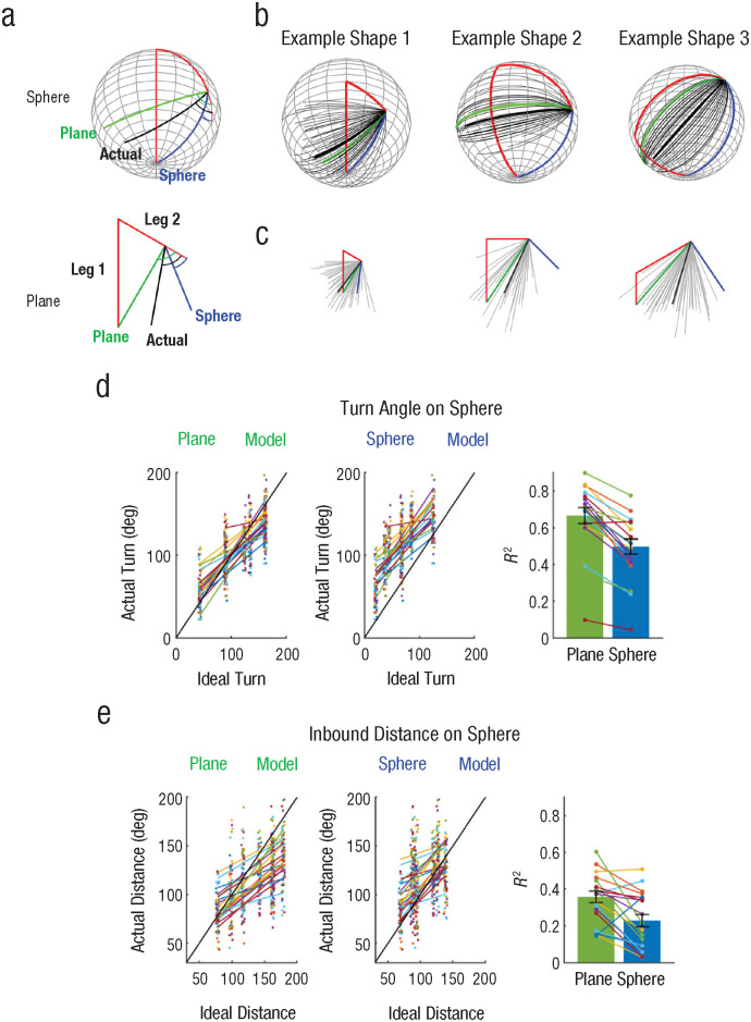
- In the triangle-completion task on the sphere, the planar-geometry model strongly outperformed the spherical model: approximated BF = 3.5e54 for turn angle and BF = 2.6e23 for distance; individual R² values were higher for the planar model than the spherical model for turn angle (0.67 ± 0.19 vs. 0.50 ± 0.18) and distance (0.36 ± 0.13 vs. 0.23 ± 0.15).
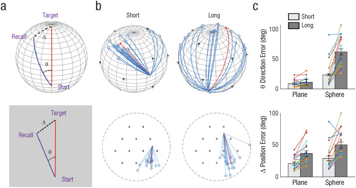
- In the object-location memory test, long-distance trials on the sphere produced a large initial direction error: the long-minus-short difference was 38.5 ± 19.4° on the sphere versus 2.5 ± 4.8° on the plane (BF = 1.1e5, interaction; t(19) = 7.7, p < .001, Cohen’s d = 1.7).
- Final position error was larger for long-distance trials on both surfaces, with no significant interaction: long-minus-short difference was 21.3 ± 18.3° on the sphere versus 15.8 ± 10.4° on the plane (BF = 0.8, t(19) = 1.3, p = .2, Cohen’s d = 0.3); mean position error for long trials on the sphere was 50.6 ± 20.4° versus chance = 90°.
- Simulations indicated that route planning using multiple planar maps can approximate spherical navigation: optimally arranged maps yielded position and direction errors of less than 20° for distant targets, while suboptimal arrangements reached up to 60° direction error and 40° position error, still below chance.
Methods
- Preregistered study with 20 healthy young adults (10 male, mean age = 26.4 years, SD = 4.8 years), tested over two days in immersive VR on an omnidirectional treadmill with a head-mounted display.
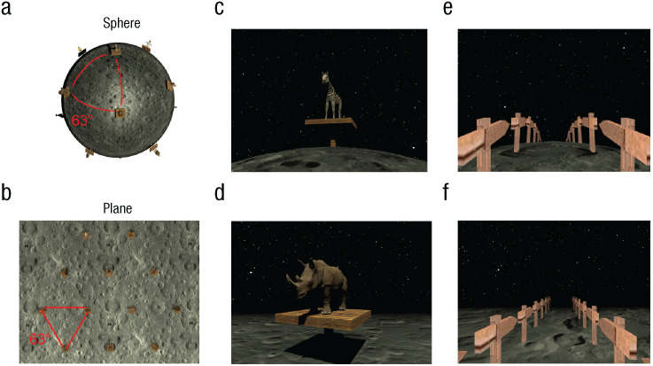
- Participants completed free exploration, object-location memory training and test, and a triangle-completion path-integration task in tightly matched spherical and planar virtual environments containing 12 animal landmarks; sphere radius was 12.5 virtual units, and neighboring landmarks were separated by 63° geodesic distance.
- Main analyses compared linear mixed models based on planar versus spherical geometry using BIC-derived Bayes factors, plus Bayesian t tests for object-location errors and simulations of route planning based on multiple planar maps.
Limitations
- The paper states that vestibular and proprioceptive input was limited because participants walked on a flat treadmill surface, and it suggests future work with additional 3D vestibular input, microgravity, or a 3D motion simulator.
- The paper states that the impact of extended experience in nonflat environments remains untested and would be valuable for understanding cognitive-map adaptability.
- Evident from the text: the sample was small (N = 20), the best-fitting spherical radius at the single-subject level should be interpreted cautiously because of few data points and reduced model discriminability, and strategy measures relied partly on self-report.
Model-written summary. Check it against the paper before relying on it.
Integrity signals
Registry
Cites
Statistics
Figures


Verification
Claims the paper makes
8 Valid · 1 Not valid · 8 Not checked · 53 Own results and interpretations
The cited sources support only part of this claim — read each source’s verdict below.
In the paper
“There is abundant evidence that neural circuitry for physical navigation can be used for organizing various types of information, including odors and social and visual features (Aronov et al., 2017; Bao et al., 2019; Bellmund et al., 2018; Gärdenfors, 2000; Park et al., 2020).”
§ Cognitive Maps for a Non-Euclidean Environment: Path Integration and Spatial Memory on a Sphere > Discussion
What the sources say
- Partly supportedcites Aronov et al., 2017 sourceExperimental — accuracy not yet measured
The Abstract (page unavailable) reports that hippocampal–entorhinal neurons involved in spatial mapping also represented a non-spatial sound-frequency task, supporting the broader point. The paper does not itself demonstrate organization of odors, social features, or visual features; those appear in the titles of works listed in its References (page unavailable). (LLM, conf=0.84)
- Supportedcites Bao et al., 2019 source
Bao et al. supports the odor example in this multi-citation sentence. The Discussion reports grid-like coding in regions associated with navigation during movement through odor space, and the Introduction describes grid cells as a neural metric for physical navigation. The sentence's social-feature example need not be supported by this citation alone. (LLM, conf=0.91)
- Not checked — no full text of the sourcecites Bellmund et al., 2018 source
boostedstates an association- Asserted: passes — The authors put it forward as true.
- Checkable: passes — It can be checked against evidence.
- Load-bearing: passes — The paper’s conclusions depend on it.
- Based: passes — The paper gives a reason why it holds.
- Partly supported
The sources with a verdict support this claim; the rest weren’t checked yet, have no full text we could read, or their verdicts aren’t rated yet.
In the paper
“Importantly, the neural circuitry for path integration (e.g., head-direction cells, grid cells) has mainly been studied when animals navigate on flat 2D surfaces, except for a few recent studies (Ginosar et al., 2021; Grieves et al., 2020; Ulsaker-Janke et al., 2023).”
§ Cognitive Maps for a Non-Euclidean Environment: Path Integration and Spatial Memory on a Sphere > Introduction
What the sources say
- Not checked — no full text of the sourcecites Ginosar et al., 2021 source
- Supportedcites Grieves et al., 2020 source
This citation serves as an example of a study beyond flat 2D navigation. The Introduction (page not provided) describes recording place cells while rats explored a three-dimensional open cubic lattice, so Grieves et al. is an instance of the exception the citing sentence identifies. The paper does not need to study head-direction or grid cells itself to serve that role. (LLM, conf=0.87)
- Not matchedcites Ulsaker-Janke et al., 2023
Couldn’t be matched to a paper in Crossref, so it can’t be checked.
plain- Asserted: passes — The authors put it forward as true.
- Checkable: passes — It can be checked against evidence.
- Load-bearing: passes — The paper’s conclusions depend on it.
- Based: passes — The paper gives a reason why it holds.
The sources with a verdict support this claim; the rest weren’t checked yet, have no full text we could read, or their verdicts aren’t rated yet.
In the paper
“studies on rodents walking on slopes or walls connected to a horizontal floor have shown that head-direction cells and grid cells continue to encode the direction and locations relative to a local surface, rather than a global 3D reference (Hayman et al., 2015; Stackman et al., 2000).”
§ Cognitive Maps for a Non-Euclidean Environment: Path Integration and Spatial Memory on a Sphere > Discussion
What the sources say
- Supportedcites Hayman et al., 2015 source
The Introduction describes rats foraging across connected horizontal and 40°-tilted surfaces. The Discussion reports that grid-cell firing on the slope was consistent with alignment to the tilted surface rather than a volumetric lattice. This supports the grid-cell-on-slopes portion for which Hayman et al. is cited; the separate head-direction-cell and wall findings are not attributed to this source alone. (LLM, conf=0.91)
- Not checked yetcites Stackman et al., 2000 source
Checked before — its earlier verdict is held back until a new check runs.
plain- Asserted: passes — The authors put it forward as true.
- Checkable: passes — It can be checked against evidence.
- Load-bearing: passes — The paper’s conclusions depend on it.
- Based: passes — The paper gives a reason why it holds.
- Supported
The cited sources support only part of this claim — read each source’s verdict below.
In the paper
“This suggests that cognitive maps may take on a graph or topographic form across multiple hierarchies (Chrastil & Warren, 2014; Peer et al., 2020).”
§ Cognitive Maps for a Non-Euclidean Environment: Path Integration and Spatial Memory on a Sphere > Discussion
What the sources say
- Partly supportedcites Chrastil & Warren, 2014 sourceExperimental — accuracy not yet measured
The Introduction describes graph knowledge and survey (map-like) knowledge as levels within a hierarchy of spatial knowledge. The Discussion says the study's results most strongly support labeled-graph knowledge in a newly learned environment, not survey knowledge. The paper does not describe multiple hierarchies, so that part of the claim is unsupported. (LLM, conf=0.83)
- Not matchedcites Peer et al., 2020
Couldn’t be matched to a paper in Crossref, so it can’t be checked.
hedgedstates a possible cause- Asserted: passes — The authors put it forward as true.
- Checkable: passes — It can be checked against evidence.
- Load-bearing: passes — The paper’s conclusions depend on it.
- Based: passes — The paper gives a reason why it holds.
- Partly supported
The sources with a verdict support this claim; the rest weren’t checked yet, have no full text we could read, or their verdicts aren’t rated yet.
In the paper
“However, it has been observed that people do not always rely on a coherent Euclidean map for navigation.”
§ Cognitive Maps for a Non-Euclidean Environment: Path Integration and Spatial Memory on a Sphere > Discussion
What the sources say
- Supportedcites Hirtle & Jonides, 1985 source
Our copy states this point repeatedly at the level the claim attributes: the Abstract/introduction concludes 'This evidence rules out the possibility that an adequate model of a mental map can be built around a strictly Euclidean conception,' and the Effects of Barriers summary says 'it would be a serious error to characterize the mental representation of physical space as a Euclidean survey map,' with non-Euclidean hierarchical structure, reference points and cluster effects distorting distance and direction judgments. The paper's own data (within- vs. across-cluster errors, asymmetric and intransitive judgments cited from Cadwallader 1979 and Sadalla et al.) support 'not always' rather than a wholesale rejection of Euclidean coding, which the claim's hedge also preserves. The only slack is that Hirtle and Jonides phrase it as spatial representation/judgment (including route-distance estimates) rather than 'navigation' in the field, a wording-level gloss rather than a missing qualifier. (LLM, conf=0.82)
- Supportedcites Kim & Maguire, 2018 source
The Introduction says people can use hierarchical planning rather than a volumetric 3D map when navigating multifloor buildings. The Discussion reports behavioral findings consistent with a segmented representation of space, supporting the claim that navigation does not always rely on one coherent Euclidean map. (LLM, conf=0.90)
- Not checked — no full text of the sourcecites Wiener & Mallot, 2003 source
plain- Asserted: passes — The authors put it forward as true.
- Checkable: passes — It can be checked against evidence.
- Load-bearing: passes — The paper’s conclusions depend on it.
- Based: passes — The paper gives a reason why it holds.
- Supported
30 more claims
Create a free account to see all 70 claims and to verify the 4 references still open.
- Probably not a substantial claim. 18
- It may state two separate claims as one. 23
- The quote only partly states this claim. 3
Statistics recomputed
Every reported test result, recomputed from its test statistic and degrees of freedom. A result shows as not adding up only once an independent check has confirmed it.
- Consistentt(19) = 1.1reported p = .85 · recomputed p = .285
“t(19) = 1.1, p = .85”
The paper states a one-tailed test
- Consistentt(19) = 7.7reported p < .001 · recomputed p < .001
“t(19) = 7.7, p < .001”
- Consistentt(19) = 1.3reported p = .2 · recomputed p = .209
“t(19) = 1.3, p = .2”
Self-check
Percentages, sums and reported differences re-computed from the paper’s own numbers.
Self-check results appear here once an independent check has confirmed them.
Citations
Cites
The hippocampus as a cognitive map
Passingham, R. E. (1979) · Neuroscience · doi:10.1016/0306-4522(79)90015-0 · Cited by 5,128
Path integration and the neural basis of the 'cognitive map'
McNaughton, B. L., Battaglia, F. P., Jensen, O., Moser, E. I., & Moser, M.-B. (2006) · Nature Reviews Neuroscience · doi:10.1038/nrn1932 · Cited by 2,024
Conceptual Spaces: The Geometry of Thought
Gärdenfors, P. (2000) · The MIT Press eBooks · doi:10.7551/mitpress/2076.001.0001 · Cited by 1,135
What Is a Cognitive Map? Organizing Knowledge for Flexible Behavior
Behrens, T. E. J., Muller, T. H., Whittington, J. C. R., Mark, S., Baram, A. B., Stachenfeld, K. L., & Kurth-Nelson, Z. (2018) · Neuron · doi:10.1016/j.neuron.2018.10.002 · Cited by 1,055
Mapping of a non-spatial dimension by the hippocampal-entorhinal circuit
Aronov, D., Nevers, R., & Tank, D. W. (2017) · Nature · doi:10.1038/nature21692 · Cited by 773
Evidence of hierarchies in cognitive maps
Hirtle, S. C., & Jonides, J. (1985) · Memory & Cognition · doi:10.3758/bf03197683 · Cited by 655 · cited 1×
“Spatial memory and planning is strongly influenced by regional boundaries instead of Euclidean relations alone (Hirtle & Jonides, 1985; Kim & Maguire, 2018; Wiener & Mallot, 2003).”
Navigating cognition: Spatial codes for human thinking
Bellmund, J. L. S., Gärdenfors, P., Moser, E. I., & Doeller, C. F. (2018) · Science · doi:10.1126/science.aat6766 · Cited by 643
Self-citationSpatial representation in the hippocampal formation: a history
Moser, E. I., Moser, M.-B., & McNaughton, B. L. (2017) · Nature Neuroscience · doi:10.1038/nn.4653 · Cited by 560
Estimating power in (generalized) linear mixed models: An open introduction and tutorial in R
Kumle, L., Võ, M. L.-H., & Draschkow, D. (2021) · Behavior Research Methods · doi:10.3758/s13428-021-01546-0 · Cited by 552
Toroidal topology of population activity in grid cells
Gardner, R. J., Hermansen, E., Pachitariu, M., Burak, Y., Baas, N. A., Dunn, B. A., Moser, M.-B., & Moser, E. I. (2022) · Nature · doi:10.1038/s41586-021-04268-7 · Cited by 428 · cited 1×
“…imply that a minimal experience with a typical environment is necessary for maturation of 2D grid fields that are anchored to an environment, but the topology of grid cells for a 2D flat surface is preconfigured independently of experience (Gardner et al., 2022; Ulsaker-Janke et al., 2023).”
Cited by
Children’s Understanding of Topological Relations
Yousif, S. R., Goldstein, L. B., & Brannon, E. M. (2025) · Open Mind · doi:10.1162/opmi_a_00194 · Cited by 8
Locomotion-dependent use of geometric and body cues in humans mapping 3D space
Reisner, V., Schäfer, T. A. J., König, L., kim, M.-S., & Doeller, C. F. (2025) · Proceedings of the National Academy of Sciences · doi:10.1073/pnas.2505613122 · Cited by 2
Self-citationLi, S., Wang, Y., & Liu, L. (2026) · International Journal of Human-Computer Interaction · doi:10.1080/10447318.2026.2629518 · Cited by 1
Locomotion-dependent use of geometric and body cues in humans mapping 3D spacePreprint
Reisner, V., Schäfer, T. A., König, L., et al. (2025) · bioRxiv (Cold Spring Harbor Laboratory) · doi:10.1101/2025.03.11.642663 · Cited by 1
Self-citationMental Representations of Impossible Non-Euclidean Environments
McAvan, A. S., & McNamara, T. P. (2026) · Psychological Research · doi:10.1007/s00426-026-02297-3
Metadata
- Authors
- Kim, M., & Doeller, C. F.
- Affiliations
- Max Planck Institute for Human Cognitive and Brain Sciences, Leipzig, Germany
- Max Planck Institute for Human Cognitive and Brain Sciences (DE)
- Venue
- Psychological Science
- Publisher
- SAGE Publications
- Published
- 2024-10-25
- Volume
- 35
- Issue
- 11
- Pages
- 1217-1230
- ISSN
- 0956-7976 (ISSN-L)
- 1467-9280
- PMC
- PMC13020992
- OpenAlex
- W4403761054
- Semantic Scholar
- f674a5c0ecbe9e533dffa3a1af8d87e5b2377fbf
- Cited by
- 9
- References
- 40
- Citations by year
- 2026: 7 · 2025: 2
- FWCI
- 0.97
- Type
- journal article
- Language
- en
- Open access
- hybrid
- doi.org
- Licence
- cc-by
- creativecommons.org/licenses/by/4.0/ (vor)
- journals.sagepub.com/page/policies/text-and-data-mining-license (tdm)
- Locations
- Psychological Science (publishedVersion, cc-by)
- PubMed Central (publishedVersion, cc-by)
- PubMed (publishedVersion)
- Qucosa (Saxon State and University Library Dresden) (submittedVersion, cc-by)
- MPG.PuRe (Max Planck Society) (submittedVersion, cc-by)
- PsyArXiv (OSF Preprints) (submittedVersion, cc-by)
- Funders
- max-planck-gesellschaft
- european research council (ERC-CoG GEOCOG 724836)
- kavli foundation
- Jebsen Foundation
- helse midt-norge
- norges forskningsråd (223262/F50; 197467/F50)
- Topics
- Social Sciences › Psychology › Experimental and Cognitive Psychology › Spatial Cognition and Navigation
- Life Sciences › Neuroscience › Cognitive Neuroscience › Memory and Neural Mechanisms
- Social Sciences › Geography, Planning and Development › Geography Education and Pedagogy
- Keywords
- cognitive maps, path integration, spatial memory, non-Euclidean geometry, mental models, spatial navigation, virtual reality
- MeSH terms
- Virtual Reality, Adult, Cognition, Female, Humans, Male, Space Perception, Young Adult, Spatial Memory, Spatial Navigation
About these checks
Registry, retraction, Cites and statistics results are computed, not judged, with one exception: a printed reference that no index lists is read once by a model before it counts as a citation error. Claims are extracted by a model and kept only when their quote appears verbatim in the text; each cited source is then checked, with a model’s help, for whether it says what the claim relies on. Those verdicts can be wrong — read the claim’s quote and the cited source before relying on one.
The claim verdicts this report counts are experimental: their accuracy is not yet measured.
A language model drew the claims from the paper on 2026-10-10, under version 3 of the claim definition (model deepseek-v4.1-flash, prompt extract-v3).
A second model labelled each claim on 2026-10-10 (model jev-1.13-20260917, definition revision gold-guideline-v0.2).
Cited sources are checked with a language model’s help (gpt-6-sol and qwen3.8-omni-flash).
Statistics and arithmetic are recomputed, not judged.
Confidence bands are shown only for fields calibrated on our annotated test set. None is calibrated yet, so no band is shown.
What counts as a claim ›How we measure confidence ›How we check this ›
Are you an author, or do you see a problem with this page? Request a review
How to cite
Cite CoChat for the checks on this page, and the paper for its own findings.
- This page
- CoChat. (2026). Citation check: Cognitive Maps for a Non-Euclidean Environment: Path Integration and Spatial Memory on a Sphere. https://app.cochat.ai/papers/10.1177/09567976241279291
- The paper
- Kim, M., & Doeller, C. F. (2024). Cognitive Maps for a Non-Euclidean Environment: Path Integration and Spatial Memory on a Sphere. Psychological Science. https://doi.org/10.1177/09567976241279291
Data sources
Bibliographic data: Semantic Scholar, OpenAlex, Crossref.
Contains information from the Semantic Scholar Academic Graph Datasets, made available under the ODC Attribution License (ODC-BY 1.0).
Semantic Scholar’s data is described in: Kinney, R., et al. (2023). The Semantic Scholar Open Data Platform. arXiv:2301.10140.
