

Flood Susceptibility Mapping through the GIS-AHP Technique Using the Cloud
Open accessThe DOI matches its Crossref record; 55 of the 55 references it cites were found in a registry or an index.
Abstract
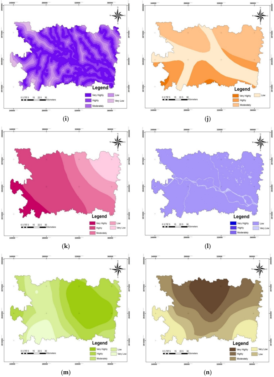
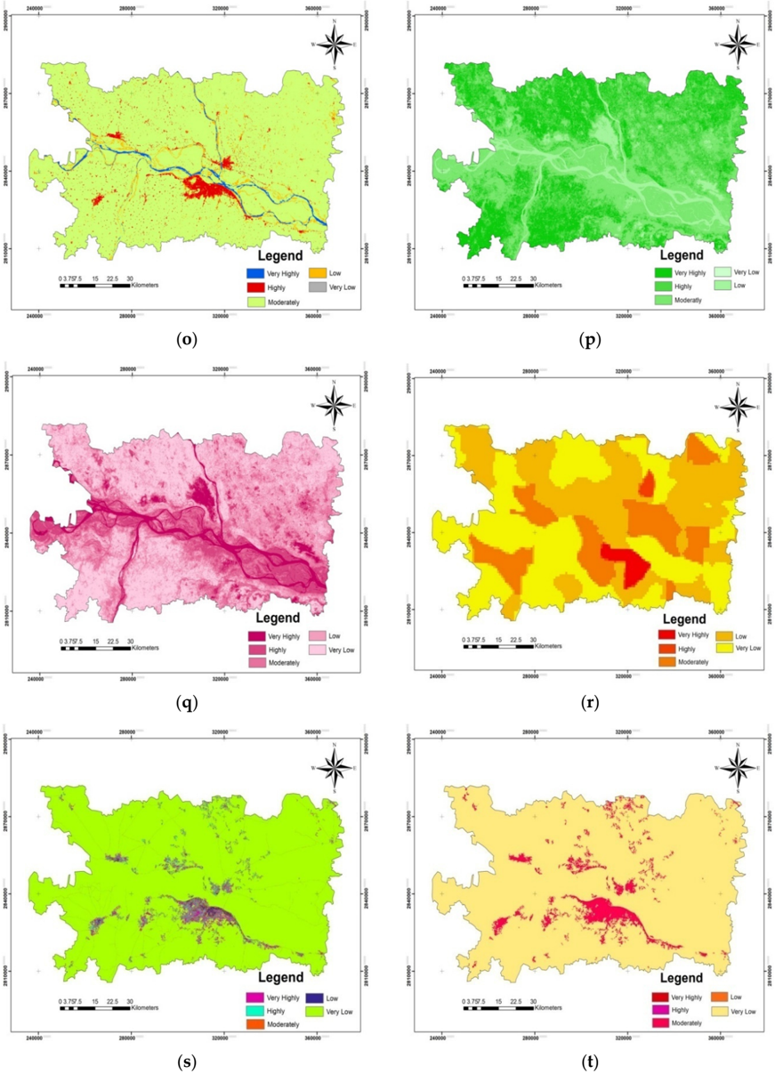
Flood susceptibility mapping is essential for characterizing flood risk zones and for planning mitigation approaches. Using a multi-criteria decision support system, this study investigated a flood susceptible region in Bihar, India. It used a combination of the analytical hierarchy process (AHP) and geographic information system (GIS)/remote sensing (RS) with a cloud computing API on the Google Earth Engine (GEE) platform. Five main flood-causing criteria were broadly selected, namely hydrologic, morphometric, permeability, land cover dynamics, and anthropogenic interference, which further had 21 sub-criteria. The relative importance of each criterion prioritized as per their contribution toward flood susceptibility and weightage was given by an AHP pair-wise comparison matrix (PCM). The most and least prominent flood-causing criteria were hydrologic (0.497) and anthropogenic interference (0.037), respectively. An area of ~3000 sq km (40.36%) was concentrated in high to very high flood susceptibility zones that were in the vicinity of rivers, whereas an area of ~1000 sq km (12%) had very low flood susceptibility. The GIS-AHP technique provided useful insights for flood zone mapping when a higher number of parameters were used in GEE. The majorities of detected flood susceptible areas were flooded during the 2019 floods and were mostly located within 500 m of the rivers’ paths.
Overview
The claims and statistics of this paper haven’t been checked yet.
Free: it reads the open-access text and checks the first 5 claims that cite a source we can check. Create a free account to check every claim.
Integrity signals
Registry
Cites
Statistics
Figures




Verification
Claims the paper makes
The claims and statistics of this paper haven’t been checked yet.
Free: it reads the open-access text and checks the first 5 claims that cite a source we can check. Create a free account to check every claim.
Claims other papers make about this one
Each is checked against this paper’s own text: does it say what the citing paper says it does?
The source backs part of the claim, not all of it — or backs it for a different population, condition or comparison.
In the citing paper
“Elevation significantly impacts flood vulnerability, with lower-lying areas typically facing a higher risk of flooding, especially in coastal regions [59,60].”
From Urban Flood Vulnerability Assessment in Freetown, Sierra Leone: AHP Approach (2024) · cites this paper as [59]
Experimental — accuracy not yet measured
Self-check
Percentages, sums and reported differences re-computed from the paper’s own numbers.
The self-check needs the paper’s full text.
Citations
Cites
Red and photographic infrared linear combinations for monitoring vegetation
Tucker, C. J. (1979) · Remote Sensing of Environment · doi:10.1016/0034-4257(79)90013-0 · Cited by 11,754 · cited 1×
“In our study, the GEE platform utilized the resampling cubic convolution of Landsat 8 (Collection-1 Tier-1) calibrated reflectance values for Path: 141 and Row: 42 (covering the study area) images with supporting metadata between 20 August 2019 and 20 October 2019 with cloud-free images (<5% cloud cover) for SAVI and…”
MethodA soil-adjusted vegetation index (SAVI)
Huete, A. R. (1988) · Remote Sensing of Environment · doi:10.1016/0034-4257(88)90106-x · Cited by 7,948 · cited 1×
“A wide range of such data sets are available, such as GHSL and gridded population of the world (GPW) [48,49].”
BackgroundBEVEN, K. J., & KIRKBY, M. J. (1979) · Hydrological Sciences Bulletin · doi:10.1080/02626667909491834 · Cited by 6,670
Renard, K. G., Foster, G. R., Weesies, G. A., McCool, D. K., & Yoder, D. C. (1996) · Cited by 4,785
Optimization by the Analytic Hierarchy Process
Saaty, T. L. (1979) · doi:10.21236/ada214804 · Cited by 4,466
Effective and efficient global optimization for conceptual rainfall‐runoff models
Duan, Q., Sorooshian, S., & Gupta, V. (1992) · Water Resources Research · doi:10.1029/91wr02985 · Cited by 3,310 · cited 1×
“ANN has been extensively used for flood susceptibility mapping [18,19]; however, it has drawbacks, such as over-fitting and under-fitting, slow learning, the curse of dimensionality, and slow convergence to a local optimum; in addition, its performance for processing complex hydrological phenomena has been inadequate…”
BackgroundAyalew, L., & Yamagishi, H. (2005) · Geomorphology · doi:10.1016/j.geomorph.2004.06.010 · Cited by 1,913 · cited 1×
“AHP is a multi-perspective multi-objective decision-making model that enables users and planners to quantitatively derive a scale of preference drawn from a set of alternatives [51].”
BackgroundTehrany, M. S., Pradhan, B., & Jebur, M. N. (2014) · Journal of Hydrology · doi:10.1016/j.jhydrol.2014.03.008 · Cited by 1,005 · cited 3×
“In our study, the GEE platform utilized the resampling cubic convolution of Landsat 8 (Collection-1 Tier-1) calibrated reflectance values for Path: 141 and Row: 42 (covering the study area) images with supporting metadata between 20 August 2019 and 20 October 2019 with cloud-free images (<5% cloud cover) for SAVI and…”
BackgroundInfluentialKhosravi, K., Pham, B. T., Chapi, K., Shirzadi, A., Shahabi, H., Revhaug, I., Prakash, I., & Tien Bui, D. (2018) · Science of The Total Environment · doi:10.1016/j.scitotenv.2018.01.266 · Cited by 792
Choubin, B., Moradi, E., Golshan, M., Adamowski, J., Sajedi-Hosseini, F., & Mosavi, A. (2019) · Science of The Total Environment · doi:10.1016/j.scitotenv.2018.10.064 · Cited by 787
Research works printed but not linked: 4
- Amin, K. Application of Remote Sensing and GIS in Flash Flood Hazard Mapping and Hydraulic Design (Case Study of Wadi Dahdah, Saudi Arabia). 2019. Available online: https://www.academia.edu/20126182/ Application_of_Remote_Sensing_and_GIS_for_Floodplain_mapping_and_Hydraulic_design (accessed on 1 January 2020).
- Center for International Earth Science Information Network-CIESIN-Columbia University (CIESIN). Gridded Population of the World, Version 4 (GPWv4): Basic Demographic Characteristics, Revision 11; NASA Socioeconomic Data and Applications Center (SEDAC): Palisades, NY, USA, 2018. Available online: https: //sedac.ciesin.columbia.edu/data/collection/gpw-v4 (accessed on 10 May 2019). [CrossRef]
- Pesaresi, M.; Ehrilch, D.; Florczyk, A.J.; Freire, S.; Julea, A. GHS Built-Upgrid, Derived from Landsat, Multitemporal (1975, 1990, 2000, 2014) (versionR2015); European Commission, Joint Research Centre (JRC): Ispra, Italy, 2019. Available online: http://data.europa.eu/89h/jrc-ghsl-hs_built_ldsmt_globe_r2015b (accessed on 21 April 2019).
- Saaty, T.L.; Vargas, G.L. Models, Methods, Concepts, and Applications of the Analytic Hierarchy Process. Int. Ser. Oper. Res. Manag. Sci. 2001, 32, 93. [CrossRef]
Cited by
Items 201–287 of 287
Yıldız, B., & Gürgöze, S. (2026) · DergiPark (Istanbul University) · doi:10.65652/jag.1905456 · Cited by 1
Tosin-Orimolade, A., Rahman, M. K., & Ipede, O. (2026) · Climate · doi:10.3390/cli14050108 · Cited by 1
“The 5-class reclassification scheme is a standard, validated practice in GIS-based flood susceptibility modeling [41,42].”
Johany, S. A., Jamalfaisal, S. I., Mia, M. S., Rahman, M. T., Ismail, M., Hasan, M. M., Kayes, I., Shahriar, S. A., & Habiba, U. (2026) · Discover Water · doi:10.1007/s43832-026-00398-z · Cited by 1
“The majority of these zones are located near rivers, consistent with earlier findings that proximity to rivers increases flood susceptibility [55, 56].”
Jaman, T., Bhaskar, S., Swain, S. K., & Alam, S. (2026) · Global and earth surface processes change. · doi:10.1016/j.gespch.2026.100021 · Cited by 1
Khan, M., Chen, R., & Khan, S. (2026) · Hydrology · doi:10.3390/hydrology13070170 · Cited by 1
“Sensitivity = TP TP + FN Specificity = TN TN + FP (20) In addition to accuracy assessment, Receiver Operating Characteristic (ROC) curve analysis was performed to evaluate the model’s discrimination ability [69].”
Ermolaeva, O., Kurashkin, S. O., Puchkova, O. S., Babkina, A. V., & Иванов, О. В. (2026) · Геология и геофизика Юга России · doi:10.46698/vnc.2026.61.21.001 · Cited by 1
Hazra, S. (2026) · NG Civil Engineering · doi:10.66132/ngce20260204 · Cited by 1
Kurniawan, A. A., Sunardi, S., Hendarmawan, H., & Ridwansyah, I. (2026) · Discover Applied Sciences · doi:10.1007/s42452-026-09191-y · Cited by 2
Evaluating Waterlogging Risk Inequality in a Megacity
Zheng, X., Zhu, Z., Ma, Y., Wu, W., Peng, D., & Zhao, Y. (2026) · Remote Sensing · doi:10.3390/rs18142428 · Cited by 1
“River density (RID) is also adopted as an indicator to characterize a possible effect of river networks on the occurrence of waterlogging [42,43].”
Mugabe, A., Kabera, T., Majoro, F., Mbereyaho, L., & Nema, M.-L. (2026) · GeoHazards · doi:10.3390/geohazards7030095 · Cited by 1
Thapa, N., Uddin, K., Thapa, R. B., & Udas, E. (2026) · Discover Geoscience · doi:10.1007/s44288-026-00670-8 · Cited by 1
Quantifying Changes in Sundarbans Mangrove Forest Through GEE Cloud Computing Approach
Singha, C., & Swain, K. C. (2022) · Algorithms for intelligent systems · doi:10.1007/978-981-19-0332-8_9 · Cited by 1
Self-citationMckenzie, R., & Gala, T. S. (2023) · Journal of environment and earth science · doi:10.7176/jees/13-6-04 · Cited by 1
Path analysis for alternative safe route access during floods in Kota Kinabalu, Sabah
Taileh, V., Rasam, A. R. A., Lin, S., Saraf, N. M., & Ghazali, R. (2023) · AIP conference proceedings · doi:10.1063/5.0169044 · Cited by 1
Flood Susceptibility Mapping Using GIS-AHP of Kuala Krai
Nizamani, Z., Soomro, R. A., Nakayama, A., & Ali, M. O. A. (2024) · Lecture notes in civil engineering · doi:10.1007/978-981-99-1111-0_5 · Cited by 1
Moharir, K. N., Singh, M., Pande, C. B., & Varade, A. M. (2024) · Environmental science and engineering · doi:10.1007/978-3-031-38004-4_14 · Cited by 2
Atemoagbo, O. P., Otache, M. Y., Animashaun, I. M., & Chukwu, S. E. (2024) · International Journal Of Engineering And Computer Science · doi:10.18535/ijecs/v13i03.4798 · Cited by 6
Azmar, N. A. S., Shah, R. N. F. A. R. M., Azmi, M. S. M., Karim, N. S. A., Husin, N. H. M., Misron, N., & Sari, E. R. (2024) · Semarak International Journal of Civil and Structural Engineering · doi:10.37934/sijcse.1.1.4252 · Cited by 1
Narzary, M., Dey, P., Patnaik, S. K., & Riming, T. (2025) · Environmental science and engineering · doi:10.1007/978-3-031-82311-4_8 · Cited by 1
Pradhan, P., Bajpai, R., & Patra, S. (2025) · Elsevier eBooks · doi:10.1016/b978-0-443-27372-8.00025-8 · Cited by 1
Nyereyegona, M. D. J., Mazhindu, A. N., & Chirenje, K. C. (2025) · Scientific Reports · doi:10.1038/s41598-025-90220-y · Cited by 1
“Furthermore, approximately 25% of the study area is highly suitable for the siting of the transmitters, and the area includes ward 22, 23, 24, and 29.”
An approach for real-time monitoring of hydrological risk hotspots during extreme rainfall events
Shakti, P. C., Hirano, K., & Iizuka, S. (2025) · Geomatics Natural Hazards and Risk · doi:10.1080/19475705.2025.2524420 · Cited by 1
“Evaluating flood hazard and vulnerability while considering various indicators within a geographic information system (GIS) framework can provide valuable insights for policymakers (Wang et al. 2011; Li et al. 2019; Swain et al. 2020; Diriba et al. 2024) and insurance companies (P.C. et al. 2023).”
Mckenzie, R., & Gala, T. S. (2022) · Research Square · doi:10.21203/rs.3.rs-2285275/v1 · Cited by 1
Flood Susceptibility Mapping in the Baitarani River basin, implementing cloud-based IS-AHP TechniquePreprint
Sethi, R. R., Dandapat, A. K., Jena, S., Sankalp, S., Panda, D. K., & Patra, P. K. (2022) · Research Square · doi:10.21203/rs.3.rs-2339371/v1
Silva-López, J. O., Pérez, H. V. V., & Zabaleta-Santisteban, J. A. (2023) · Revista Científica Dékamu Agropec · doi:10.55996/dekamuagropec.v4i1.136
“La textura del suelo se generó en base a las capas de contenido de arena, limo y arcilla (Hengl et al., 2017) y promediando todas las capas de las profundidades 0–5 cm y 5–15 cm (Silva López et al., 2022).”
Backgroundالنمذجة المكانية للسيول في حوض وادي زبيد- اليمن
صلاح, ب. م. ن. (2024) · journal of the college of basic education · doi:10.35950/cbej.v30i123.11253
Ajijola, S. O., Adedire, F. M., & Fadamiro, J. A. (2024) · CSID Journal of Infrastructure Development · doi:10.7454/jid.v7.i1.1110
Sediment production susceptibility index in urban area: a case study of Campo Grande – MS, Brazil
de Moraes, R. B. F., Bacchi, C. G. V., & Gonçalves, F. V. (2024) · Revista Brasileira de Recursos Hídricos · doi:10.1590/2318-0331.292420240001
Bedada, A. B., Feyisa, G. L., Kassa, A. K., Mwanjalolo, M., Gabiri, G., Bekele, D. A., & Tesfaye, G. (2026) · Physics and Chemistry of the Earth Parts A/B/C · doi:10.1016/j.pce.2026.104465
Vulnerable Markets: Impact of Extreme Flooding on Agriculture Supply Networks in Punjab, PakistanPreprint
Asad, S. A., Gondal, O. H., & Said, F. (2025) · SSRN Electronic Journal · doi:10.2139/ssrn.5040333
Das, S., Bandyopadhyay, J., Acharyya, N., & Maity, S. (2025) · Environmental science and engineering · doi:10.1007/978-3-031-82311-4_3 · Cited by 1
Gonsalis, S. S., Math, S. D., Naidu, K., S, R. N. H., Dang, A., Rajendra, V. N., Vincent, S., Kumar, O. P., & Mohan, V. (2024) · International Conference on Artificial Intelligence, Computational Electronics and Communication System (AICECS) · doi:10.1109/aicecs63354.2024.10956247
da Paz, D. H. F., de Meneses, E. A., Aniceto, F. D. S., Esteves, L. V., & da Silva, P. V. (2025) · Anais do Terceiro Sustentare e Sexto Wipis · doi:10.29327/sustentare-wipis-2024.1021921
Njeru, E. M., Olago, D. O., Obiero, J. P. O., & Olaka, L. A. (2025) · Advances in Remote Sensing · doi:10.4236/ars.2025.143007
Almeida, J. D. S., da Silveira, M. A. P., Francisco, E. D. R., & Limongi, R. (2025) · GEOgraphia · doi:10.22409/geographia2025.v26i59.a51506
Sarkar, S., & Bera, B. (2025) · Proceedings of the Indian National Science Academy · doi:10.1007/s43538-025-00638-1
An integrated machine learning framework for flood susceptibility assessment
Shirani, K., & Pasandi, M. (2025) · Elsevier eBooks · doi:10.1016/b978-0-443-26722-2.00014-3
Mapping of Flood Risk Areas and Prevention Measures: A Case Study of Foum Elkhanga Watershed
Balla, F. (2025) · Journal of Information Systems Engineering & Management · doi:10.52783/jisem.v10i4.13689
“The RI data were obtained from the results of the randomly selected PCM, which was constructed from the pairwise comparison table in a random and inconsistent manner (Swain et al., 2020).”
Flood susceptibility analysis with GIS and remote sensing; the case of the West Black sea
Mızraklı, C. (2023) · Istanbul Technical University Academic Open Archive (Istanbul Technical University)
Dynamic flood hazard mapping in greater Bandung using the Cox proportional hazards model
Putra, R. P., Virtriana, R., Setyadji, A. B., & Agustina, R. D. (2025) · Modeling Earth Systems and Environment · doi:10.1007/s40808-025-02703-6
“In addition, MCDA-AHP is generally static, providing a snapshot of hazard conditions without considering temporal variability or dynamic environmental changes, which are crucial in developing flood scenarios driven by climate change or urban expansion (Choudhury et al. 2022 ; Swain et al. 2020).”
Adhikari, P. (2025) · Journal of Nepal Geological Society · doi:10.3126/jngs.v69i1.88319
“Some of the commonly used flood susceptibility mapping analysis techniques include multi-criteria decision analysis, logistic regression, frequency ratio approach, weight of evidences equations, k-nearest neighbor logic and analytic network process framework (Swain et al. 2020).”
Hada, S., & Thakuri, P. S. (2025) · Journal of Water Engineering and Management · doi:10.47884/jweam.v6i3pp25-38
“Previous research on flood mapping with MCDA-AHP techniques adopts the process of pair-wise discrete comparison of all the selected parameters in a single-step (Swain et al., 2020; Parsian et al., 2021; Chaulagain et al., 2023; Mokhtari et al., 2023).”
Flood Susceptibility Assessment of the Hudson Bay Railway
Moqadam, A. Z. Z. (2025) · Carleton University's Institutional Repository (MacOdrum Library, Carleton University) · doi:10.22215/etd/2025-16832
Nguyen, T., Bui, M. H., Vu, T. B. N., & Dinh, T. T. (2025) · Социально-гуманитарные исследования: векторы развития науки и образования · doi:10.25686/foreco.2025.23.10.003
Assessment of Flood Susceptibility in Conakry, Guinea Using GIS-Based AHP Multi-Criteria AnalysisPreprint
Traore, S., Keita, O., Kanté, I. K., Posite, V. R., & Sylla, M. (2026) · Research Square · doi:10.21203/rs.3.rs-8729603/v1
Hakim, D. K., Gernowo, R., & Nirwansyah, A. W. (2026) · Informatica · doi:10.31449/inf.v50i5.8164
Mehmood, M. S., Zhai, S., Ahamad, M. İ., Abbas, S., Rehman, A., & Yaochen, Q. (2026) · Springer eBooks · doi:10.1007/978-3-032-12225-4_5
Islam, T., Zeleke, E. B., & Melesse, A. M. (2026) · Earth · doi:10.3390/earth7020036
Koley, S., Alam, M., & Kumar, S. N. (2026) · Journal of Earth System Science · doi:10.1007/s12040-026-02781-9
Flood hazard modeling and community-based participatory mapping in Gweta, Central District, Botswana
Nawa, M., Toteng, E. N., & Kelepile, M. (2026) · African Geographical Review · doi:10.1080/19376812.2026.2651519
Flood Susceptibility Assessment of Nethravathi River Basin, Karnataka, Through GIS-AHP Technique
Nirmala, R. (2026) · Springer eBooks · doi:10.1007/978-3-032-11300-9_27
Sudha, S., Govindaraju, G., Rakesh, C. J., & Lokanath, S. (2026) · Evolving Earth · doi:10.1016/j.eve.2026.100126
Mundayatt, A., & Sreevalsan‐Nair, J. (2026) · IEEE Journal of Selected Topics in Applied Earth Observations and Remote Sensing · doi:10.1109/jstars.2026.3743755
“Traditional methods, including expert-based weighting schemes [15], [16], [17], [18], [19], [20] and empirical statistical models [21], [22], [23], [24], [25], [26], are often computationally efficient and interpretable, but are generally less effective in representing complex non-linear…”
Rashid, M. U., & Anas, M. (2026) · World Environmental and Water Resources Congress (EWRI) · doi:10.1061/9780784486931.027
Senan, C. P. P. C., Ajin, R. S., Rajaneesh, A., Nagar, J. K., & Sajinkumar, K. S. (2026) · Water Resources · doi:10.1134/s0097807824606149
Usaard, N., Boonnan, P., Nonbudsri, J., Kiriwongwattana, K., & Cansee, S. (2026) · Journal of Hydrology Regional Studies · doi:10.1016/j.ejrh.2026.103494
Ismail, A. M., Makwinja, R., Farah, F. J., Mekonnen, A., & Salah, K. M. (2026) · Scientific African · doi:10.1016/j.sciaf.2026.e03580
GIS-Based Analysis of Factors Associated with Flood Risk in Sta. Rosa, Nueva Ecija
Matabang, K. R., Alvior, R. G., Bayudan, P. A. S., Cruz, K. K. F. D., Eugenio, A. B., Gelardo, C. K. G., & Babalcon, R. V. (2026) · Engineering and Technology Journal · doi:10.47191/etj/v11i05.19
GIS and exploratory regression-based flood susceptibility mapping in the Muhuri River Basin, India
Shah, A. I., Basumatary, J., & Pan, N. D. (2026) · Discover Geoscience · doi:10.1007/s44288-026-00555-w
“Elevation information is the basis for delineating flood-risk areas since low-lying areas tend to be more prone to water pooling under heavy precipitation or river flooding [55].”
Flood Vulnerability Mapping of Ogbaru Local Government Area, Anambra State, Nigeria
Uju, I. O., & Lay, U. S. (2026) · Southern space studies · doi:10.1007/978-3-032-25251-7_17
Getahun, Y. S., Eshetie, A. Z., Pandey, R. S., Shefine, B. G., Abebe, T. G., & Leta, E. D. (2026) · Sustainable Futures · doi:10.1016/j.sftr.2026.102006
Loc, N. D., Nguyen, K.-N., & Tran, T. P. (2026) · Environmental Research Communications · doi:10.1088/2515-7620/ae8aba
Explainable machine learning for flood susceptibility mapping in Kyrgyzstan’s major urban areas
Linh, N. T. T., Singha, C., Rana, V. K., Duulatov, E., Łupikasza, E. B., & Pham, Q. B. (2026) · Scientific Reports · doi:10.1038/s41598-026-58498-8
Self-citationRoy, A., & Roy, P. (2026) · Progress in Disaster Science · doi:10.1016/j.pdisas.2026.100649
Maftei, C. E., Cojocariu, L. L., & COPACEAN, L. (2026) · Land · doi:10.3390/land15071303
Essahlaoui, N., Ouali, A. E., Mohajane, M., Essahlaoui, A., Ijlil, S., Rhazi, A., Alitane, A., Ammari, Z., Oumou, A., Khrabcha, A., et al. (2026) · Remote Sensing · doi:10.3390/rs18152500 · Cited by 1
Permatasari, R., Firda, A., Natakusumah, D. K., Yaylacı, M., & Ammarullah, M. I. (2026) · Geocarto International · doi:10.1080/10106049.2026.2714596
Jaafar, N. H., Ponrahono, Z., Bakar, A. A., Aziz, F. A., & Kafi, K. M. (2026) · PLANNING MALAYSIA · doi:10.21837/pm.v24i43.2122
Banerjee, S. (2026) · Advances in geographical and environmental sciences · doi:10.1007/978-981-92-0702-2_10
GIS-Based Mapping of Water Ponding Areas in Residential Zones of Lamongan District, Indonesia
Utomo, J. T. K., Wibisana, H., & Aryaseta, B. (2026) · AJARCDE (Asian Journal of Applied Research for Community Development and Empowerment) · doi:10.29165/ajarcde.v10i3.1248
GIS-Based Flood Hazard Mapping Using Weighted Overlay in Bekasi City
Adzkia, L. N., Setiawan, H., & Ardiansyah, A. N. (2026) · Jambura Geoscience Review · doi:10.37905/jgeosrev.v8i2.37870
Flood susceptibility mapping using analytic hierarchy process hybrid with machine learning model
Li, J., Wang, K., Jiang, L., Chen, X. F., & Hong, H. (2026) · Geoscience Frontiers · doi:10.1016/j.gsf.2026.102431
Integration of GIS and AHP for flood hazard zonation in the Kashmir Region of Pakistan
Ihsan, H. L., Waseem, M., Tanoli, W. A., & Khan, A. A. (2026) · KSCE Journal of Civil Engineering · doi:10.1016/j.kscej.2026.100719
Abed, M., Neshat, A., & Sharafati, A. (2026) · Scientific Reports · doi:10.1038/s41598-026-68131-3
“Another study stated that rainfall, topography, and soil significantly affect flood occurrence 57 .”
Singh, N., Sekhar, S., De, M., Singh, S. K., & Sharma, R. K. (2026) · Sustainable Geosciences People Planet and Prosperity · doi:10.1016/j.susgeo.2026.100034
ALLALOU, R., Hebib, R., Bersi, M., Lefkir, A., Mahiaoui, M. Y., & Chikh, B. (2026) · Journal of African Earth Sciences · doi:10.1016/j.jafrearsci.2026.106359
Tomeseleke, C. L., KISANGALA, M. M., Miti, F. T., Umul, J.-J. U., Ntombi, A. M. M., MFUANKATU, A. Y., Tshibangu, D. K., Herve, S. K., Makanzu, F. I., & Didier Ngunga, Y. I. N. A. (2026) · Journal Africain des Sciences · doi:10.70237/jafrisci.2026.v3.i10.08
Purwanto, Latifah, S., Yonariza, Darwo, Fauzan, S., & Sofiana, E. I. (2026) · Geoheritage · doi:10.1007/s12371-026-01443-y
“…Ratio CI Consistency Index, which is obtained through the calculation of the following formula: where: Max eigenvalue of judgment matrix obtained from the calculation with the following formula: AHP values are said to be valid and consistent when they have a CR value < 0.10 (Swain et al. 2020 ).”
InfluentialZogaris, S., Mentzafou, A., Zarris, D., Stappas, N., Petroglou, P., Giakoumi, S., Karaouzas, I., & Dimitriou, E. (2026) · Sustainability · doi:10.3390/su18199825
Neogy, S., Polley, P. K., Shib, S., Das, S., Basu, K., & Saha, U. D. (2026) · Bulletin of Geography Physical Geography Series · doi:10.12775/bgeo-2026-0009
“…modelling floods is a multi-dimensional, dynamic task wherein a multitude of factors are supposed to be taken into considera - tion, but the identification of parameters plays a crucial role as flood inundation is sensitive to these parameters locally (Islam and Barman 2020; Swain et al. 2020).”
Salim Mohammed Al-Waili, Z. A. L. (2023) · International Journal of Intelligent Systems and Applications in Engineering
Scenario-Based Flood Hazard and Risk Assessment Using Multi-Criteria Analysis in Semarang City
Huda, M. N., Anwar, N. K. M., Pramono, S. R. R., Aini, S. N., & Masruroh, H. (2026) · Jurnal Pembangunan Wilayah dan Kota · doi:10.14710/jpwk.v22i3.81040
“…increasingly adopted advanced remote sensing technologies and geospatial analytical approaches to support comprehensive flood risk assessment (Basak et al., 2022; Jha & Gundimeda, 2019; Matheswaran et al., 2019; Pandey et al., 2010; Sarkar et al., 2022; Swain et al., 2020; Tripathi et al., 2022).”
Rivera, C. A., Valqui-Reina, S. V., Carranza, D., Bravo, E., & Vergara, A. J. (2026) · Frontiers in Environmental Science · doi:10.3389/fenvs.2026.1935148
Metaheuristic Optimization Techniques for Machine Learning Applications for Flood Risk AnalysisPreprint
Vandhana, T. V., & Gopinath, G. (2026) · SSRN Electronic Journal · doi:10.2139/ssrn.7612189
Flood Susceptibility Mapping in San Antonio, Texas Using the Analytical Hierarchy Process and GIS
Mayukh, A. A. A., Chowdhury, M. S., Kim, Y. J., & Youn, S. (2026) · IEEE International Geoscience and Remote Sensing Symposium (IGARSS) · doi:10.1109/igarss60577.2026.11730587
“To address the need for spatially explicit hazard assessment, this research offers an integrated framework of Analytical Hierarchy Process (AHP) and Geographic Information Systems (GIS) to synthesize several conditioning factors and generate a solid flood-susceptibility map of the region [2].”
Bridging Geomythology and Geospatial Analysis for Flood Risk Assessment in Tamil Nadu
Kushwah, S., Jodhani, K. H., Dave, N., & Patel, D. (2026) · Journal of Flood Risk Management · doi:10.1111/jfr3.70266
Metadata
- Authors
- Swain, K. C., Singha, C., & Nayak, L.
- Affiliations
- Visva-Bharati University (IN)
- ICAR-NINFET, 12 Regent Park, Kolkata 700040, India
- Corresponding author
- Swain, Kishore Chandra
- Venue
- ISPRS International Journal of Geo-Information
- Publisher
- MDPI AG
- Published
- 2020-12-02
- Volume
- 9
- Issue
- 12
- Pages
- 720
- ISSN
- 2220-9964 (ISSN-L)
- OpenAlex
- W3109806479
- Cited by
- 273
- References
- 55
- Citations by year
- 2026: 61 · 2025: 64 · 2024: 52 · 2023: 46 · 2022: 36 · 2021: 13 · 2020: 1
- FWCI
- 8.65
- Type
- journal article
- Language
- en
- Open access
- gold
- doi.org
- Licence
- Locations
- ISPRS International Journal of Geo-Information (publishedVersion, cc-by)
- DOAJ (DOAJ: Directory of Open Access Journals) (submittedVersion, cc-by-sa)
- Topics
- Physical Sciences › Environmental Science › Global and Planetary Change › Flood Risk Assessment and Management
- Physical Sciences › Environmental Science › Environmental Engineering › Groundwater and Watershed Analysis
- Physical Sciences › Environmental Science › Management, Monitoring, Policy and Law › Landslides and related hazards
- Keywords
- flood susceptibility mapping, flood risk areas, multi-criteria decision support system, analytic hierarchy process, Google Earth Engine, cloud computing, human disturbance, land cover dynamics, river proximity
About these checks
Registry, retraction, Cites and statistics results are computed, not judged, with one exception: a printed reference that no index lists is read once by a model before it counts as a citation error. Claims are extracted by a model and kept only when their quote appears verbatim in the text; each cited source is then checked, with a model’s help, for whether it says what the claim relies on. Those verdicts can be wrong — read the claim’s quote and the cited source before relying on one.
Statistics and arithmetic are recomputed, not judged.
Confidence bands are shown only for fields calibrated on our annotated test set. None is calibrated yet, so no band is shown.
What counts as a claim ›How we measure confidence ›How we check this ›
Are you an author, or do you see a problem with this page? Request a review
Data sources
Bibliographic data: Semantic Scholar, OpenAlex, Crossref.
Contains information from the Semantic Scholar Academic Graph Datasets, made available under the ODC Attribution License (ODC-BY 1.0).
Semantic Scholar’s data is described in: Kinney, R., et al. (2023). The Semantic Scholar Open Data Platform. arXiv:2301.10140.
