

The DOI matches its Crossref record; 1 of the 1 references it cites were found in a registry or an index.
Linking Ecosystem Service and MSPA to Construct Landscape Ecological Network of the Huaiyang Section of the Grand Canal
Abstract
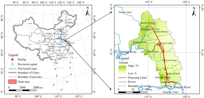
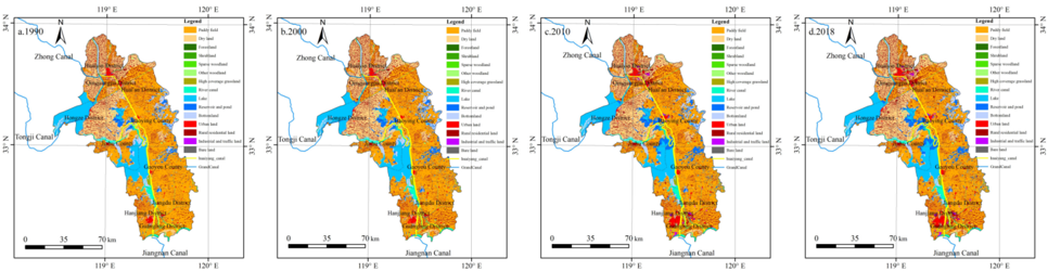
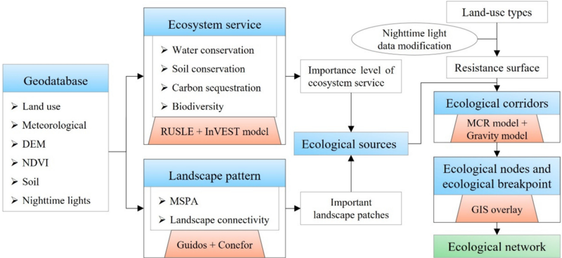
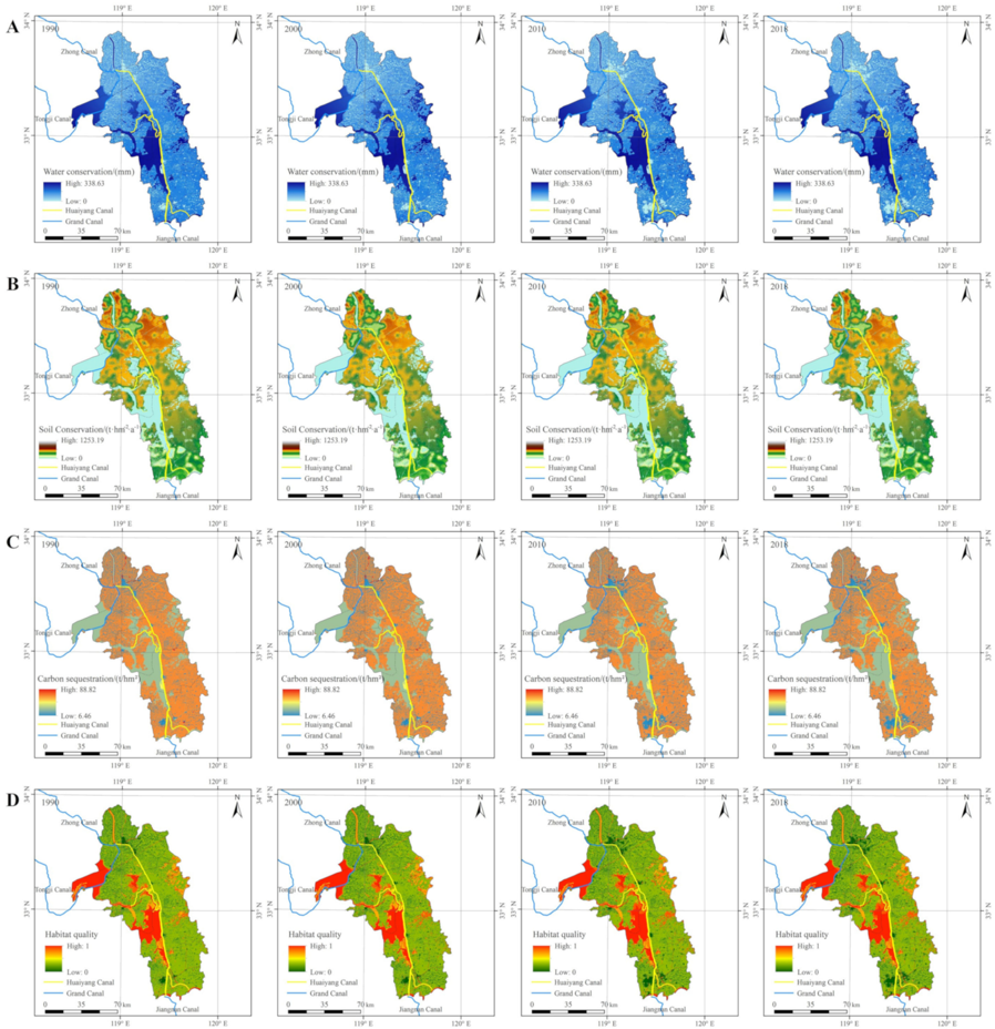
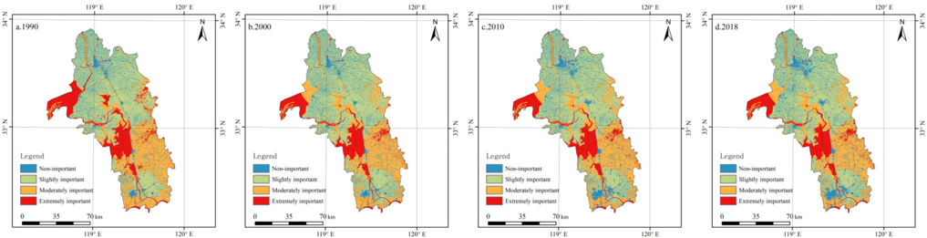
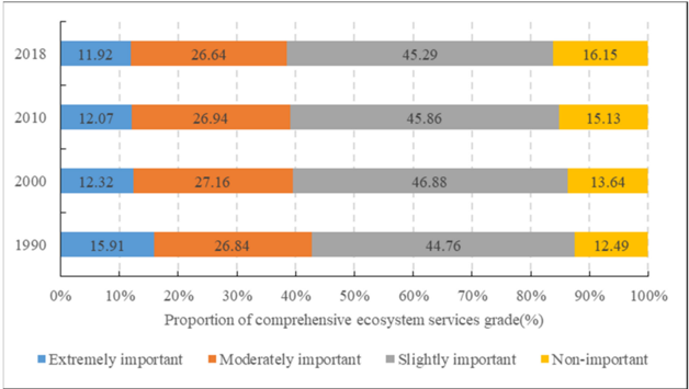
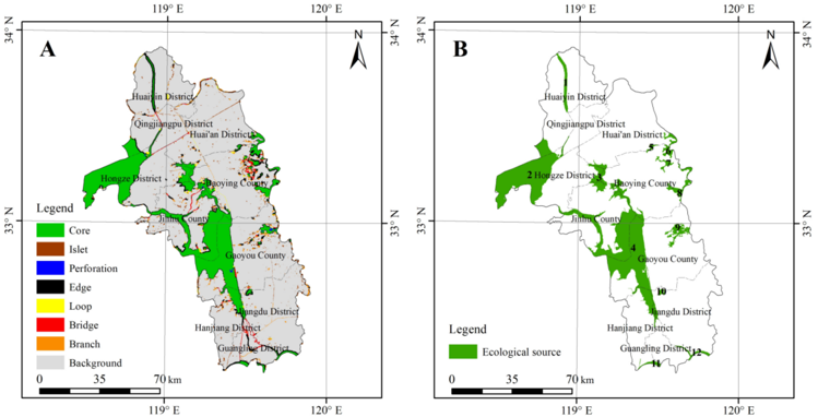
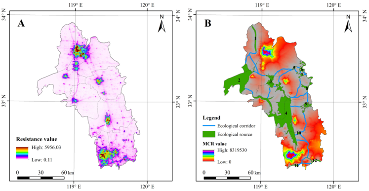
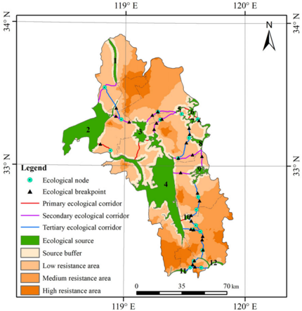
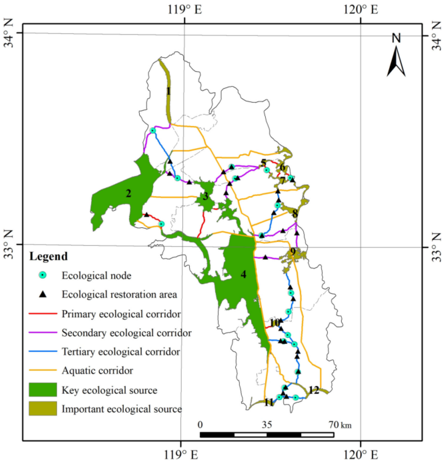
Rapid urbanization and drastic land-use change have led to landscape fragmentation and ecological environment deterioration in the regions along the Grand Canal. Building an ecological network is an important means to improve the connectivity of habitat patches and carry out ecological protection and restoration of territorial space, which is of great significance to ensure regional biodiversity and ecological security. In this article, we took the Huaiyang Section of the Grand Canal (Huaiyang Canal) as the study area, used the ecosystem service assessment model, morphological spatial pattern analysis (MSPA), and the landscape connectivity evaluation method to identify ecological sources, then used the minimum cumulative resistance (MCR) model and the gravity model to extract and grade ecological corridors. Based on these, the ecological network was constructed by combining the identification method of ecological nodes and ecological breakpoints. The aim of this was to provide a reference for the ecological space optimization of Huaiyang Canal and even the entire Grand Canal, the formulation of an ecological protection plan, and the implementation of territorial space ecological restoration. The results showed that the spatial distribution of the water conservation service, soil conservation service, carbon sequestration service, and biodiversity conservation service were significantly different, and the level of ecosystem services showed a trend of continuous degradation from 1990 to 2018. There were 12 ecological source patches comprehensively identified by multiple methods, with a total area of 2007.06 km2. In terms of spatial distribution, large ecological source patches were mainly distributed in the central and western areas adjacent to the Grand Canal, while small ecological source patches were scattered in the eastern and southern border regions of the study area. The total length of ecological corridors was 373.84 km, of which the number of the primary ecological corridor, secondary ecological corridor, and tertiary ecological corridor were 9, 7, and 7, respectively, and the suitable width of the ecological corridor was 200–400 m. After optimization, the proposed ecological network was composed of 3 key ecological source patches, 9 important ecological source patches, 23 terrestrial corridors, 10 aquatic corridors, and 18 ecological nodes. Twenty-nine ecological breakpoints were key areas requiring ecological restoration. The overlap rate of the integrated ecosystem service change area and land-use change area was 99%, indicating that land-use change has a significant impact on regional ecosystem services. This study is of great significance for carrying out the ecological protection and restoration of the Huaiyang Canal and adjusting local land-use policies. It also provides a typical case demonstration for identifying an ecological network and formulating ecological restoration planning for other sections of the Grand Canal and cities along the canal.
Overview
The claims and statistics of this paper haven’t been checked yet.
Run the check — free, no account needed. It reads the open-access text and checks the sources it cites.
Integrity signals
Registry
Cites
Statistics
Figures
Verification
Claims the paper makes
The claims and statistics of this paper haven’t been checked yet.
Run the check — free, no account needed. It reads the open-access text and checks the sources it cites.
Claims other papers make about this one
Each is checked against this paper’s own text: does it say what the citing paper says it does?
In the citing paper
“Thirdly, the existing research has primarily focused on the categorization of ecological corridors [30][31][32] while ignoring the classification of heritage corridors.”
From Circuit theory-based cultural heritage corridor network development in qin river basin (2025) · cites this paper as [32]
Self-check
Percentages, sums and reported differences re-computed from the paper’s own numbers.
The self-check needs the paper’s full text.
Citations
Cites
High frequency of functional extinctions in ecological networks
Säterberg, T., Sellman, S., & Ebenman, B. (2013) · Nature · doi:10.1038/nature12277 · Cited by 226
Research works printed but not linked: 89
- Li, 2021, Estimation of remote sensing based ecological index along the Grand Canal based on PCA-AHP-TOPSIS methodology, Ecol. Indic. Toxicol., 122, 107214, 10.1016/j.ecolind.2020.107214 · DOI
- Shen, 2020, Pollution level and ecological risk assessment of heavy metals in riverside sediments of the Grand Canal (Beijing, Tianjin and Hebei section), Bull. Environ. Contam. Toxicol., 105, 440, 10.1007/s00128-020-02957-z · DOI
- Wang, 2010, Spatial and seasonal variations of the contamination within water body of the Grand Canal, China, Environ. Pollut., 158, 1513, 10.1016/j.envpol.2009.12.018 · DOI
- Li, 2020, Spatiotemporal variations of land urbanization and socioeconomic benefits in a typical sample zone: A case study of the Beijing-Hangzhou Grand Canal, Appl. Geogr., 117, 102187, 10.1016/j.apgeog.2020.102187 · DOI
- Cai, 2019, Introduction of Beijing-Hangzhou Grand Canal and analysis of its heritage values, J. Hydro-Environ. Res., 26, 2, 10.1016/j.jher.2018.10.002 · DOI
- Zhang, 2020, Mismatched canal conservation and the authorized heritage discourse in urban China: A case of the Hangzhou Section of the Grand Canal, Int. J. Herit. Stud., 26, 105, 10.1080/13527258.2019.1608458 · DOI
- Xu, Y., Rollo, J., Jones, D.S., Esteban, Y., Tong, H., and Mu, Q. (2020). Towards Sustainable Heritage Tourism: A Space Syntax-Based Analysis Method to Improve Tourists’ Spatial Cognition in Chinese Historic Districts. Buildings, 10. · DOI
- Zhuang, 2016, A new index for assessing heavy metal contamination in sediments of the Beijing-Hangzhou Grand Canal (Zaozhuang Segment): A case study, Ecol. Indic., 69, 250, 10.1016/j.ecolind.2016.04.029 · DOI
- Piao, 2017, Perfluoroalkyl substances in waters along the Grand Canal, China, Chemosphere, 179, 387, 10.1016/j.chemosphere.2017.03.133 · DOI
- Shi, 2012, An approach to analyzing spatial patterns of protozoan communities for assessing water quality in the Hangzhou section of Jing-Hang Grand Canal in China, Environ. Sci. Pollut. Res., 19, 739, 10.1007/s11356-011-0615-0 · DOI
- Liu, 2021, Ecological network analysis and construction: A case study of the urban agglomeration of the Min River Delta, Chin, Resour. Sci., 43, 357
- Pili, 2019, Landscape and the city: Agro-forest systems, land fragmentation and the ecological network in Rome, Italy, Urban For. Urban Green, 41, 230, 10.1016/j.ufug.2019.04.016 · DOI
- Cunha, 2019, Methodology for mapping the national ecological network to mainland Portugal: A planning tool towards a green infrastructure, Ecol. Indic., 104, 802, 10.1016/j.ecolind.2019.04.050 · DOI
- Edge, 2020, Habitat network topology influences the importance of ecological traps in metapopulations, Ecosphere, 11, e03146, 10.1002/ecs2.3146 · DOI
- Zhao, 2019, Landscape pattern analysis and ecological network planning of Tianjin City, Urban For. Urban Green, 46, 126479, 10.1016/j.ufug.2019.126479 · DOI
- Zhang, 2021, Identification and optimization of ecological network in the plain area of the lower Yangtze River: A case study of Jintan District, Changzhou, Acta Ecol. Sin., 41, 3449
- Tang, 2020, Construction of county-level ecological security pattern based on ecological protection red line and network in China, Trans. Chin. Soc. Agric. Eng., 36, 263
- Liu, 2017, Research progress on landscape ecological networks, Acta Ecol. Sin., 37, 3947
- Gurrutxaga, 2010, GIS-based approach for incorporating the connectivity of ecological networks into regional planning, J. Nat. Conserv., 18, 318, 10.1016/j.jnc.2010.01.005 · DOI
- Ahern, 1991, Planning for an extensive open space system: Linking landscape structure and function, Landsc. Urban Plan., 6, 131, 10.1016/0169-2046(91)90037-M · DOI
- Linehan, 1995, Greenway planning: Developing a landscape ecological network approach, Landsc. Urban Plan., 33, 179, 10.1016/0169-2046(94)02017-A · DOI
- 2000, A multi-level ecological network in the Czech Republic: Implementating the territorial system of ecological stability, GeoJournal, 51, 211, 10.1023/A:1017518529210 · DOI
- Jongman, 2011, The pan European ecological network: PEEN, Landsc. Ecol., 26, 311, 10.1007/s10980-010-9567-x · DOI
- Gobster, 2004, The human dimensions of urban greenways: Planning for recreation and related experiences, Landsc. Urban Plan., 68, 147, 10.1016/S0169-2046(03)00162-2 · DOI
- Bascompte, 2010, Ecology structure and dynamics of ecological networks, Science, 329, 765, 10.1126/science.1194255 · DOI
- Delmas, 2018, Analysing ecological networks of species interactions, Biol. Rev., 94, 1
- 2020, The structure of ecological networks across levels of organization, Annu. Rev. Ecol. Evol. Syst., 51, 433, 10.1146/annurev-ecolsys-012220-120819 · DOI
- Guo, 2021, Construction of municipal ecological space network based on MCR model, Trans. Chin. Soc. Agric. Mach., 52, 275
- Jongman, 2004, European ecological networks and greenways, Landsc. Urban Plan., 68, 305, 10.1016/S0169-2046(03)00163-4 · DOI
- Swiader, 2017, Building ecological networks in Slovakia and Poland, Ekologia, 36, 303
- Zhang, 2017, Coupling ecosystem services supply and human ecological demand to identify landscape ecological security pattern: A case study in Beijing-Tianjin-Hebei region, China, Urban Ecosyst., 20, 701, 10.1007/s11252-016-0629-y · DOI
- Peng, 2018, Linking ecosystem services and circuit theory to identify ecological security patterns, Sci. Total Environ., 644, 781, 10.1016/j.scitotenv.2018.06.292 · DOI
- Dong, 2021, Integrating regional and interregional approaches to identify ecological security patterns, Landsc. Ecol., 36, 2151, 10.1007/s10980-021-01233-7 · DOI
- Wang, 2021, Promoting landscape connectivity of highly urbanized area: An ecological network approach, Ecol. Indic., 125, 107487, 10.1016/j.ecolind.2021.107487 · DOI
- Song, S., Xu, D.W., Hu, S.S., and Shi, M.X. (2021). Ecological Network Optimization in Urban Central District Based on Complex Network Theory: A Case Study with the Urban Central District of Harbin. Int. J. Environ. Res. Public Health, 18. · DOI
- Orantes, M.J.C., Kim, J., and Kim, J. (2017). Socio-Cultural Asset Integration for a Green Infrastructure Network Plan in Yesan County, Korea. Sustainability, 9. · DOI
- Jiang, X., and Zhao, T.Y. (2020). Research on the Spatial Structure of County Greenway Network Based on Gravitation-Resistance Measurement-A Case Study of Ning’an in China. Sustainability, 12. · DOI
- Yu, 2018, Optimization of ecological node layout and stability analysis of ecological network in desert oasis: A typical case study of ecological fragile zone located at Deng Kou County (Inner Mongolia), Ecol. Indic., 84, 304, 10.1016/j.ecolind.2017.09.002 · DOI
- Fu, 2020, Identification and optimization strategy of county ecological security pattern: A case study in the Loess Plateau, China, Ecol. Indic., 112, 106030, 10.1016/j.ecolind.2019.106030 · DOI
- Zhou, D., and Song, W. (2021). Identifying ecological corridors and networks in mountainous areas. Int. J. Environ. Res. Public Health, 18. · DOI
- Cong, 2020, Determination of landscape ecological network of wetlands in the Yellow River Delta, Wetlands, 40, 2729, 10.1007/s13157-020-01357-7 · DOI
- Kharrazi, 2016, Evaluating the evolution of the Heihe River basin using the ecological network analysis: Efficiency, resilience, and implications for water resource management policy, Sci. Total. Environ., 572, 688, 10.1016/j.scitotenv.2016.06.210 · DOI
- Shi, 2020, Ecological network construction of the heterogeneous agro-pastoral areas in the upper Yellow River basin, Agric. Ecosyst. Environ., 302, 107069, 10.1016/j.agee.2020.107069 · DOI
- Zhou, 2021, Assessing an ecological security network for a rapid urbanization region in Eastern China, Land Degrad. Dev., 21, 2642, 10.1002/ldr.3932 · DOI
- Dai, 2021, Integrating the MCR and DOI models to construct an ecological security network for the urban agglomeration around Poyang Lake, China, Sci. Total. Environ., 754, 141868, 10.1016/j.scitotenv.2020.141868 · DOI
- Xu, 2021, Construction of landscape ecological network based on landscape ecological risk assessment in a large-scale opencast coal mine area, J. Clean. Prod., 286, 125523, 10.1016/j.jclepro.2020.125523 · DOI
- Jalkanen, 2020, Identification of ecological networks for land-use planning with spatial conservation prioritization, Landsc. Ecol., 32, 353, 10.1007/s10980-019-00950-4 · DOI
- Jakiel, M., and Bernatek, A. (2015). Assessment of an ecological network at local scale in the context of landscape changes: A case study from NE Poland. Landscape Analysis and Planning, Springer Geography, Springer International Publishing. · DOI
- Zhang, 2021, An optimized evaluation method of an urban ecological network: The case of the Minhang District of Shanghai, Urban For. Urban Green, 62, 127158, 10.1016/j.ufug.2021.127158 · DOI
- Shi, 2019, Biodiversity conservation of mountains-rivers-forests-farmlands-lakes-grasslands using an ecological network: A case study on the Zuoyoujiang River basin in Guangxi Province, China, Acta Ecol. Sin., 39, 8930
- Jia, 2017, Developing and optimizing ecological networks for the towns along the Three Gorges Reservoir: A case of Kaizhou New Town, Chongqing, Chin. J. Ecol., 36, 779
- Jiang, 2021, Linking ecological background and demand to identify ecological security patterns across the Guangdong-Hong Kong-Macao Greater Bay Area in China, Landsc. Ecol., 36, 2135, 10.1007/s10980-021-01234-6 · DOI
- Shen, 2021, Identifying and setting the natural spaces priority based on the multi-ecosystem services capacity index, Ecol. Indic., 125, 107473, 10.1016/j.ecolind.2021.107473 · DOI
- Xiao, 2020, An evaluation framework for designing ecological security patterns and prioritizing ecological corridors: Application in Jiangsu Province, China, Landsc. Ecol., 35, 2517, 10.1007/s10980-020-01113-6 · DOI
- Chen, 2020, The optimization of urban ecological network planning based on the minimum cumulative resistance model and granularity reverse method: A case study of Haikou, China, IEEE Access, 8, 43592, 10.1109/ACCESS.2020.2976548 · DOI
- Tang, 2018, Construction of ecological corridors in Changli County based on ecological sensitivity and ecosystem service values, Chin. J. Appl. Ecol., 29, 2675
- Takahashi, 1980, The empirical formula of evaporation estimated by monthly mean temperature and precipitation, Meteorol. Sci. Technol., S4, 48
- Elvidge, C.D., Zhizhin, M., Ghosh, T., Hsu, F.C., and Taneja, J. (2021). Annual time series of global VIIRS nighttime lights derived from monthly averages: 2012 to 2019. Remote. Sens., 13. · DOI
- Yang, 2021, Spatiotemporal variations and influencing factors of soil conservation service in Ziwuling Area, J. Soil Water Conserv., 35, 188
- Liu, 2020, Soil conservation efficiency assessment based on land use scenarios in the Nile River Basin, Ecol. Indic. Toxicol., 119, 106864, 10.1016/j.ecolind.2020.106864 · DOI
- Arnoldus, H.M.J. (1980). An Approximation of the Rainfall Factor in the Universal Soil Loss Equation, John Wiley and Sons Ltd. Press.
- Williams, 1996, Using soil erosion models for global change studies, J. Soil Water Conserv., 51, 381
- Wischmeier, 1976, Use and misuse of universal soil loss equation, J. Soil Water Conserv., 31, 5
- Liu, B.Y., Xie, Y., and Zhang, K.L. (2001). Soil Erosion Prediction Model, China Science and Technology Press.
- Tang, F. (2019). Research on Ecological Security Pattern in Qinglong County based on Ecological Protection Red Line and Ecological Network. [Master’s Thesis, Hebei Agricultural University].
- Zha, 2015, Dynamic changes of soil erosion in the Chaohu Watershed from 1992 to 2013, Acta Geogr. Sin., 70, 1708
- Zhu, 2019, Assessment of territorial ecosystem carbon storage based on land use change scenario: A case study in Qihe River Basin, Acta Geogr. Sin., 74, 446
- Chen, 2007, Total below ground carbon allocation in China’s forests, Acta Ecol. Sin., 27, 5148
- Giardina, 2000, Evidence that decomposition rates of organic carbon in mineral soil do not vary with temperature, Nature, 404, 858, 10.1038/35009076 · DOI
- Alam, 2013, Tree biomass and soil organic carbon densities across the Sudanese woodland savannah: A regional carbon sequestration study, J. Arid. Environ., 89, 67, 10.1016/j.jaridenv.2012.10.002 · DOI
- Tang, 2020, Land-use change in Changli County, China: Predicting its spatio-temporal evolution in habitat quality, Ecol. Indic., 117, 106719, 10.1016/j.ecolind.2020.106719 · DOI
- Tang, F., Fu, M.C., Wang, L., Song, W.J., Yu, J.F., and Wu, Y.B. (2021). Dynamic evolution and scenario simulation of habitat quality under the impact of land-use change in the Huaihe River Economic Belt, China. PLoS ONE, 16. · DOI
- Terrado, 2016, Model development for the assessment of terrestrial and aquatic habitat quality in conservation planning, Sci. Total Environ., 540, 63, 10.1016/j.scitotenv.2015.03.064 · DOI
- Sun, 2019, Monitoring spatio-temporal dynamics of habitat quality in Nansihu Lake basin, eastern China, from 1980 to 2015, Ecol. Indic., 102, 716, 10.1016/j.ecolind.2019.03.041 · DOI
- Xu, L.T., Chen, S.S., Xu, Y., Li, G.Y., and Su, W.Z. (2019). Impacts of Land-Use Change on Habitat Quality during 1985–2015 in the Taihu Lake Basin. Sustainability, 11. · DOI
- Vogt, 2009, Mapping functional connectivity, Ecol. Indic., 9, 64, 10.1016/j.ecolind.2008.01.011 · DOI
- Saura, 2011, Key structural forest connectors can be identified by combining landscape spatial pattern and network analyses, Forest Ecol. Manag., 262, 150, 10.1016/j.foreco.2011.03.017 · DOI
- Saura, 2006, Comparison and development of new graph-based landscape connectivity indices: Towards the priorization of habitat patches and corridors for conservation, Landsc. Ecol., 21, 959, 10.1007/s10980-006-0013-z · DOI · Paper page
- Gao, 2020, Integrating ecosystem services and rocky desertification into identification of karst ecological security pattern, Landsc. Ecol., 36, 2113, 10.1007/s10980-020-01100-x · DOI
- Peng, 2018, Identification and optimization of ecological security pattern in Xiong’an New Area, Acta Geogr. Sin., 73, 701
- Knaapen, 1992, Estimating habitat isolation in landscape planning, Landsc. Urban Plan., 23, 1, 10.1016/0169-2046(92)90060-D · DOI
- Xu, 2018, Ecological corridor construction based on important ecological nodes in Duliujian River Basin, Res. Environ. Sci., 31, 805
- Zhu, 2005, The width of ecological corridor in landscape planning, Acta Ecol. Sin., 25, 2406
- Dong, 2021, Entwining ecosystem services, Land Use Change and human well-being by nitrogen flows, J. Clean. Prod., 308, 127442, 10.1016/j.jclepro.2021.127442 · DOI
- Arunyawat, S., and Shrestha, R.P. (2016). Assessing Land Use Change and Its Impact on Ecosystem Services in Northern Thailand. Sustainability, 8. · DOI
- Kim, 2021, Assessing the impacts of urban land use changes on regional ecosystem services according to urban green space policies via the patch-based cellular automata model, Environ. Manag., 61, 192, 10.1007/s00267-020-01394-2 · DOI
- Koo, 2019, Impact assessment of land use changes using local knowledge for the provision of ecosystem services in northern Ghana, West Africa, Ecol. Indic., 103, 156, 10.1016/j.ecolind.2019.04.002 · DOI
- Bai, 2019, Impact of land use and climate change on water-related ecosystem services in Kentucky, USA, Ecol. Indic., 102, 51, 10.1016/j.ecolind.2019.01.079 · DOI
- Chen, 2021, Construction of ecological network in Qinling Mountains of Shaanxi, China based on MSPA and MCR model, Chin. J. Appl. Ecol., 32, 1545
Cited by
Sorted by citations
Circuit theory-based cultural heritage corridor network development in qin river basin
Lin, Z., & Li, B. (2025) · npj Heritage Science · doi:10.1038/s40494-025-01906-5 · Cited by 24
Metadata
- Authors
- Tang, F., Zhou, X., Wang, L., Zhang, Y., Fu, M., & Zhang, P.
- Venue
- Land
- Publisher
- MDPI AG
- Published
- 2021-08-31
- Volume
- 10
- Issue
- 9
- Pages
- 919
- ISSN
- 2073-445X
- Cited by
- 54
- References
- 1
- Language
- en
- Funders
- the National Key Research and Development Project of China (Grant No. 2016YFC0502501)
- the National Natural Science Foundation of China (Grant No. 41871347)
- the Social Science Foundation of Hebei Province (Grant No. HB19YJ020)
About these checks
Registry, retraction, Cites and statistics results are computed, not judged, with one exception: a printed reference that no index lists is read once by a model before it counts as a citation error. Claims are extracted by a model and kept only when their quote appears verbatim in the text; each cited source is then checked, with a model’s help, for whether it says what the claim relies on. Those verdicts can be wrong — read the claim’s quote and the cited source before relying on one.
Statistics and arithmetic are recomputed, not judged.
Confidence bands are shown only for fields calibrated on our annotated test set. None is calibrated yet, so no band is shown.
What counts as a claim ›How we measure confidence ›How we check this ›
Are you an author, or do you see a problem with this page? Request a review
How to cite
Cite CoChat for the checks on this page, and the paper for its own findings.
- This page
- CoChat. (2026). Citation check: Linking Ecosystem Service and MSPA to Construct Landscape Ecological Network of the Huaiyang Section of the Grand Canal. https://app.cochat.ai/papers/10.3390/land10090919
- The paper
- Tang, F., Zhou, X., Wang, L., Zhang, Y., Fu, M., & Zhang, P. (2021). Linking Ecosystem Service and MSPA to Construct Landscape Ecological Network of the Huaiyang Section of the Grand Canal. Land. https://doi.org/10.3390/land10090919
