

The DOI matches its Crossref record; 48 of the 48 references it cites were found in a registry or an index.
Early human settlement of Sahul was not an accident
Open accessAbstract
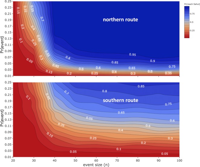
The first peopling of Sahul (Australia, New Guinea and the Aru Islands joined at lower sea levels) by anatomically modern humans required multiple maritime crossings through Wallacea, with at least one approaching 100 km. Whether these crossings were accidental or intentional is unknown. Using coastal-viewshed analysis and ocean drift modelling combined with population projections, we show that the probability of randomly reaching Sahul by any route is <5% until ≥40 adults are ‘washed off’ an island at least once every 20 years. We then demonstrate that choosing a time of departure and making minimal headway (0.5 knots) toward a destination greatly increases the likelihood of arrival. While drift modelling demonstrates the existence of ‘bottleneck’ crossings on all routes, arrival via New Guinea is more likely than via northwestern Australia. We conclude that anatomically modern humans had the capacity to plan and make open-sea voyages lasting several days by at least 50,000 years ago.
Overview
The claims and statistics of this paper haven’t been checked yet.
Run the check — free, no account needed. It reads the open-access text and checks the sources it cites.
Integrity signals
Registry
Cites
Statistics
Figures
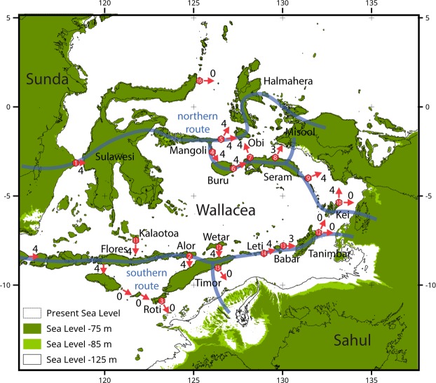
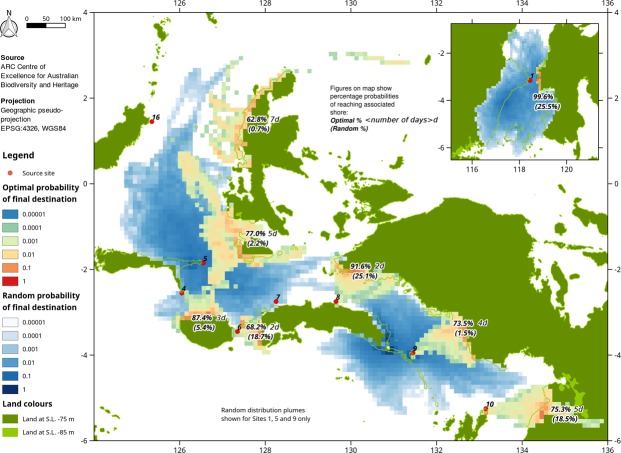
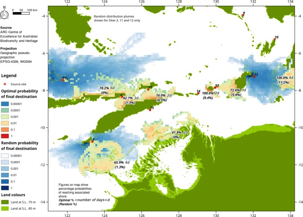
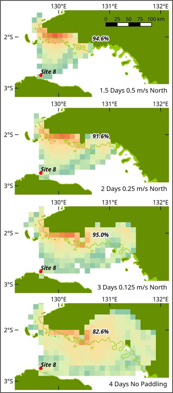
Verification
Claims the paper makes
The claims and statistics of this paper haven’t been checked yet.
Run the check — free, no account needed. It reads the open-access text and checks the sources it cites.
Claims other papers make about this one
Each is checked against this paper’s own text: does it say what the citing paper says it does?
The source backs part of the claim, not all of it — or backs it for a different population, condition or comparison.
In the citing paper
“Nonetheless, the current fossil and archaeological records, together mounting genetic evidence from across ISEA, point to the widespread presence of archaic hominins east of Wallace's Line 26 , and indicate that the first AMH populations to arrive in ISEA most likely encountered a variety of hominin populations, no matter which route they took to enter Sahul 4752 .”
From Widespread Denisovan ancestry in Island Southeast Asia but no evidence of substantial super-archaic hominin admixture (2021) · cites this paper as [52]
Experimental — accuracy not yet measuredThe source backs part of the claim, not all of it — or backs it for a different population, condition or comparison.
In the citing paper
“Our resulting network explicitly identifies vectors of connectivity among regions that have so far only been qualitatively inferred from linguistic 57,58 , genetic 59,60 , or archaeological 24,27,28 data (although see recent work by Pedro et al. 61 that suggested vectors of connectivity); our findings are complimentary to these studies.”
From Landscape rules predict optimal superhighways for the first peopling of sahul (2021) · cites this paper as [28]
Experimental — accuracy not yet measuredThe check wasn’t confident either way, so it gives no verdict — never disputed.
In the citing paper
“explaining how people likely traversed the large and diverse continent of Sahul once they arrived so far remains largely speculative 28 .”
From Landscape rules predict optimal superhighways for the first peopling of sahul (2021) · cites this paper as [28]
Experimental — accuracy not yet measured
Self-check
Percentages, sums and reported differences re-computed from the paper’s own numbers.
The self-check needs the paper’s full text.
Citations
Cites
Human occupation of northern Australia by 65,000 years ago
Clarkson, C., Jacobs, Z., Marwick, B., Fullagar, R., Wallis, L., Smith, M., Roberts, R. G., Hayes, E., Lowe, K., Carah, X., et al. (2017) · Nature · doi:10.1038/nature22968 · Cited by 1,185
Frankham, R., Bradshaw, C. J. A., & Brook, B. W. (2014) · Biological Conservation · doi:10.1016/j.biocon.2013.12.036 · Cited by 1,162
Self-citationLongevity Among Hunter‐ Gatherers: A Cross‐Cultural Examination
Gurven, M., & Kaplan, H. (2007) · Population and Development Review · doi:10.1111/j.1728-4457.2007.00171.x · Cited by 670
Direct estimates of the Indonesian Throughflow entering the Indian Ocean: 2004–2006
Janet Sprintall, A., Wijffels, S., Molcard, R., & Jaya, I. (2009) · Journal of Geophysical Research Atmospheres · doi:10.1029/2008jc005257 · Cited by 550
Growth rates and life histories in twenty‐two small‐scale societies
Walker, R. S., Gurven, M., Hill, K. R., Migliano, A. B., Chagnon, N. A., de Souza, R., Djurovic, G., HAMES, R. B., Hurtado, A. M., Kaplan, H. S., et al. (2006) · American Journal of Human Biology · doi:10.1002/ajhb.20510 · Cited by 436
Description of the Earth system model of intermediate complexity LOVECLIM version 1.2
Goosse, H., Brovkin, V. A., Fichefet, T., Haarsma, R., Huybrechts, P., Jongma, J. I., Mouchet, A., Selten, F., Barriat, P.-Y., Campin, J., et al. (2010) · Geoscientific model development · doi:10.5194/gmd-3-603-2010 · Cited by 386
Aboriginal mitogenomes reveal 50,000 years of regionalism in Australia
Tobler, R., Rohrlach, A. B., Soubrier, J., Bover, P. R., Llamas, B., Tuke, J., Bean, N. G., Abdullah-Highfold, A., Agius, S., O’Donoghue, A., et al. (2017) · Nature · doi:10.1038/nature21416 · Cited by 376
A Competing‐Risk Model for Animal Mortality
Siler, W. (1979) · Ecology · doi:10.2307/1936612 · Cited by 368
Rethinking the dispersal of Homo sapiens out of Africa
Groucutt, H. S., Petraglia, M. D., Bailey, G. N., Scerri, E. M. L., Parton, A., Clark‐Balzan, L., Jennings, R. P., Lewis, L., Blinkhorn, J., Drake, N., et al. (2015) · Evolutionary Anthropology Issues News and Reviews · doi:10.1002/evan.21455 · Cited by 334
Defining the ‘generalist specialist’ niche for Pleistocene Homo sapiens
Roberts, P., & Stewart, B. A. (2018) · Nature Human Behaviour · doi:10.1038/s41562-018-0394-4 · Cited by 300
Research works printed but not linked: 2
- O’Connell, J. F, Allen, J. & Hawkes, K. Pleistocene Sahul and the origins of seafaring. The Global Origins and Development of Seafaring, eds Anderson, A., Barrett, J. H., Boyle, K. V. (McDonald Institute of Archaeological Research, Cambridge), pp 57–68 (2010).
- Bellwood, P. et al. 35,000 years of prehistory in the northern Moluccas. In Bartstra, G. J. (ed.). Bird’s head approaches, Irian Jaya studies, a programme for interdisciplinary research. Modern Quaternary Research in Southeast Asia. 15, 233–275 (1998).
Cited by
Sorted by citations
Roberts, P., Louys, J., Zech, J., Shipton, C., Kealy, S., Carro, S. S., Hawkins, S., Boulanger, C., Marzo, S., Fiedler, B., et al. (2020) · Nature Communications · doi:10.1038/s41467-020-15969-4 · Cited by 111
Self-citationStochastic models support rapid peopling of Late Pleistocene Sahul
Bradshaw, C. J. A., Norman, K., Ulm, S., Williams, A. N., Clarkson, C., Chadœuf, J., Lin, S. C., Jacobs, Z., Roberts, R. G., Bird, M. I., et al. (2021) · Nature Communications · doi:10.1038/s41467-021-21551-3 · Cited by 58
Self-citationGenome of a middle Holocene hunter-gatherer from Wallacea
Carlhoff, S., Duli, A., Nägele, K., Nur, M., Skov, L., Sumantri, I., Oktaviana, A. A., Hakim, B., Burhan, B., Syahdar, F. A., et al. (2021) · Nature · doi:10.1038/s41586-021-03823-6 · Cited by 107
Papuan mitochondrial genomes and the settlement of Sahul
Pedro, N., Brucato, N., Fernandes, V., André, M., Saag, L., Pomat, W., Besse, C., Boland, A., Deleuze, J.-F., Clarkson, C., et al. (2020) · Journal of Human Genetics · doi:10.1038/s10038-020-0781-3 · Cited by 48
Forty-thousand years of maritime subsistence near a changing shoreline on Alor Island (Indonesia)
Kealy, S., O’Connor, S., Mahirta, M., Sari, D. M., Shipton, C., Langley, M. C., Boulanger, C., Kaharudin, H. A. F., Patridina, E. P. B. G. G., Algifary, M. A., et al. (2020) · Quaternary Science Reviews · doi:10.1016/j.quascirev.2020.106599 · Cited by 91
Self-citationLandscape rules predict optimal superhighways for the first peopling of sahul
Crabtree, S. A., White, D. A., Bradshaw, C. J. A., Saltré, F., Williams, A. N., Beaman, R. J., Bird, M. I., & Ulm, S. (2021) · Nature Human Behaviour · doi:10.1038/s41562-021-01106-8 · Cited by 74
Self-citationA different paradigm for the initial colonisation of Sahul
Allen, J., & O’Connell, J. F. (2020) · Archaeology in Oceania/Archæology & physical anthropology in Oceania · doi:10.1002/arco.5207 · Cited by 75
Papua New Guinean Genomes Reveal the Complex Settlement of North Sahul
Brucato, N., André, M., Tsang, R., Saag, L., Kariwiga, J., Sesuki, K., Beni, T., Pomat, W. S., Muke, J., Meyer, V., et al. (2021) · Molecular Biology and Evolution · doi:10.1093/molbev/msab238 · Cited by 72
Human occupation of the Kimberley coast of northwest Australia 50,000 years ago
Norman, K., Shipton, C., O’Connor, S., Malanali, W., Collins, P., Wood, R. E., Saktura, W. M., Roberts, R. G., & Jacobs, Z. L. (2022) · Quaternary Science Reviews · doi:10.1016/j.quascirev.2022.107577 · Cited by 69
Self-citationMinimum founding populations for the first peopling of Sahul
Bradshaw, C. J. A., Ulm, S., Williams, A. N., Bird, M. I., Roberts, R. G., Jacobs, Z., Laviano, F., Weyrich, L. S., Friedrich, T., Norman, K., et al. (2019) · Nature Ecology & Evolution · doi:10.1038/s41559-019-0902-6 · Cited by 56
Self-citationHuman dispersal and plant processing in the Pacific 55 000–50 000 years ago
Gaffney, D., Tanudirjo, D. A., Djami, E. N. I., Mas’ud, Z., Macap, A. R., Russell, T., Dailom, M., Ray, Y., Higham, T., Bradshaw, F., et al. (2024) · Antiquity · doi:10.15184/aqy.2024.83 · Cited by 56
Sharif, M. B., Burgarella, C., Cormier, F., Mournet, P., Causse, S., Van, K. N., Kaoh, J., Rajaonah, M. T., Lakshan, S. R., Waki, J., et al. (2020) · Annals of Botany · doi:10.1093/aob/mcaa122 · Cited by 52
Shaw, B., Coxe, S., Haro, J., Privat, K. L., Haberle, S. G., Hopf, F., Hull, E., Hawkins, S., & Jacobsen, G. (2020) · Quaternary Science Reviews · doi:10.1016/j.quascirev.2020.106522 · Cited by 54
Teixeira, J. C., Jacobs, G. S., Stringer, C., Tuke, J., Hudjashov, G., Purnomo, G. A., Sudoyo, H., Cox, M. P., Tobler, R., Turney, C. S. M., et al. (2021) · Nature Ecology & Evolution · doi:10.1038/s41559-021-01408-0 · Cited by 51
Fuentes, R., Ono, R., Nakajima, N., Nishizawa, H., Siswanto, J., Aziz, N., Sriwigati, S., Sofian, H. O., Miranda, T., & Pawlik, A. (2019) · Journal of Archaeological Science · doi:10.1016/j.jas.2019.105031 · Cited by 48
The Archaeology of Social Transformation in the New Guinea Highlands
Gaffney, D., & Denham, T. P. (2021) · Oxford University Press eBooks · doi:10.1093/oxfordhb/9780190095611.013.31 · Cited by 46
Vallini, L., Marciani, G., Aneli, S., Bortolini, E., Benazzi, S., Pievani, T., & Pagani, L. (2022) · Genome Biology and Evolution · doi:10.1093/gbe/evac045 · Cited by 48
Ono, R., Fuentes, R., Pawlik, A., Sofian, H. O., Sriwigati, S., Aziz, N., Alamsyah, N., & Yoneda, M. (2020) · Quaternary International · doi:10.1016/j.quaint.2020.03.054 · Cited by 41
A submerged landscape at the entrance of Sahul
Boesl, F., Adhityatama, S., & Wall, A. F. (2025) · ANU Press eBooks · doi:10.22459/ta58.2024.07 · Cited by 39
The three waves: Rethinking the structure of the first Upper Paleolithic in Western Eurasia
Slimak, L. (2023) · PLoS ONE · doi:10.1371/journal.pone.0277444 · Cited by 37
The biogeographic threshold of Wallacea in human evolution
Shipton, C., O’Connor, S., & Kealy, S. (2020) · Quaternary International · doi:10.1016/j.quaint.2020.07.028 · Cited by 32
Self-citationBen-Oren, Y., Kolodny, O., & Creanza, N. (2023) · Philosophical Transactions of the Royal Society B Biological Sciences · doi:10.1098/rstb.2021.0418 · Cited by 30
Population Genomics of Yams: Evolution and Domestication of Dioscorea Species
Sugihara, Y., Kudoh, A., Tamiru, M., Takagi, H., Natsume, S., Shimizu, M., Abe, A., Asiedu, R., Asfaw, A., Adebola, P. O., et al. (2021) · Population genomics · doi:10.1007/13836_2021_94 · Cited by 31
Symbolic expression in Pleistocene Sahul, Sunda, and Wallacea
Langley, M. C., Clarkson, C., & Ulm, S. (2019) · Quaternary Science Reviews · doi:10.1016/j.quascirev.2019.105883 · Cited by 29
Self-citationNot a bathtub: A consideration of sea-level physics for archaeological models of human migration
Borreggine, M., Powell, E., Pico, T., Mitrovica, J. X., Meadow, R., & Tryon, C. A. (2021) · Journal of Archaeological Science · doi:10.1016/j.jas.2021.105507 · Cited by 23
Moore, M. W., Westaway, K., Ross, J., Newman, K., Perston, Y. L., Huntley, J., Keats, S., & Morwood, M. J. (2020) · PLoS ONE · doi:10.1371/journal.pone.0226628 · Cited by 21
Palaeolithic voyage for invisible islands beyond the horizon
Kaifu, Y., Kuo, T.-H., Kubota, Y., & Jan, S. (2020) · Scientific Reports · doi:10.1038/s41598-020-76831-7 · Cited by 22
Ono, R., Fuentes, R., Amano, N., Sofian, H. O., Sriwigati, S., Aziz, N., & Pawlik, A. (2021) · Quaternary International · doi:10.1016/j.quaint.2020.12.045 · Cited by 20
Seetah, K., Manfio, S., Balbo, A. L., Farr, H., & Florens, F. B. V. (2022) · Frontiers in Ecology and Evolution · doi:10.3389/fevo.2022.791539 · Cited by 19
Framing Australian Pleistocene coastal occupation and archaeology
Ditchfield, K., Ulm, S., Manne, T., Farr, H., O’Grady, D., & Veth, P. (2022) · Quaternary Science Reviews · doi:10.1016/j.quascirev.2022.107706 · Cited by 18
Self-citationMoonkham, P., Srinurak, N., & Duff, A. I. (2023) · Journal of Anthropological Archaeology · doi:10.1016/j.jaa.2023.101506 · Cited by 17
Scratching the Surface: Engraved Cortex as Portable Art in Pleistocene Sulawesi
Brumm, A., Langley, M. C., Hakim, B., Perston, Y. L., Suryatman, N., Oktaviana, A. A., Burhan, B., & Moore, M. W. (2020) · Journal of Archaeological Method and Theory · doi:10.1007/s10816-020-09469-4 · Cited by 17
Skeletal remains of a Pleistocene modern human (Homo sapiens) from Sulawesi
Brumm, A., Bulbeck, D., Hakim, B., Burhan, B., Oktaviana, A. A., Sumantri, I., Zhao, J., Aubert, M., Sardi, R., McGahan, D. P., et al. (2021) · PLoS ONE · doi:10.1371/journal.pone.0257273 · Cited by 18
Abrupt onset of intensive human occupation 44,000 years ago on the threshold of Sahul
Shipton, C., Morley, M. W., Kealy, S., Norman, K., Boulanger, C., Hawkins, S., Litster, M., Withnell, C., & O’Connor, S. (2024) · Nature Communications · doi:10.1038/s41467-024-48395-x · Cited by 15
Self-citationMcCarthy, J. K., Wiseman, C., Woo, K. G. P., Steinberg, D., O’Leary, M., Wesley, D., Brady, L. M., Ulm, S., & Benjamín, J. (2021) · Australian Archaeology · doi:10.1080/03122417.2021.1960248 · Cited by 16
Self-citationLeach, J., Wiseman, C., O’Leary, M., McDonald, J., McCarthy, J. K., Morrison, P., Jeffries, P., Hacker, J., Ulm, S., Bailey, G. N., et al. (2021) · Australian Archaeology · doi:10.1080/03122417.2021.1949085 · Cited by 15
Self-citationEstimating crossing success of human agents across sea straits out of Africa in the Late Pleistocene
Hölzchen, E., Hertler, C., Willmes, C., Anwar, I. P., Mateos, A., Rodrı́guez, J., Berndt, J. O., & Timm, I. J. (2022) · Palaeogeography Palaeoclimatology Palaeoecology · doi:10.1016/j.palaeo.2022.110845 · Cited by 20
Genomic evidence supports the “long chronology” for the peopling of Sahul
Gandini, F., Almeida, M., Foody, M. G. B., Nagle, N., Bergström, A., Olivieri, A., Rodrigues, S., Fichera, A., Oteo‐García, G., Torroni, A., et al. (2025) · Science Advances · doi:10.1126/sciadv.ady9493 · Cited by 14
Self-citationRock art from at least 67,800 years ago in Sulawesi
Oktaviana, A. A., Joannes‐Boyau, R., Hakim, B., Burhan, B., Sardi, R., Adhityatama, S., Jalandoni, A., Hamrullah, Sumantri, I., Tang, M., et al. (2026) · Nature · doi:10.1038/s41586-025-09968-y · Cited by 26
Island Migration, Resource Use, and Lithic Technology by Anatomically Modern Humans in Wallacea
Ono, R., Pawlik, A., & Fuentes, R. (2020) · IntechOpen eBooks · doi:10.5772/intechopen.93819 · Cited by 14
Fuentes, R., Ono, R., Aziz, N., Sriwigati, S., Alamsyah, N., Sofian, H. O., Miranda, T., Faiz, & Pawlik, A. (2021) · Journal of Archaeological Science Reports · doi:10.1016/j.jasrep.2021.102905 · Cited by 14
Physiography, foraging mobility, and the first peopling of Sahul
Salles, T., Joannes‐Boyau, R., Moffat, I., Husson, L., & Lorcery, M. (2024) · Nature Communications · doi:10.1038/s41467-024-47662-1 · Cited by 16
A synthetic model of Palaeolithic seafaring in the Ryukyu Islands, southwestern Japan
Kaifu, Y. (2022) · World Archaeology · doi:10.1080/00438243.2022.2121317 · Cited by 14
Pleistocene Archaeology - Migration, Technology, and Adaptation
Ono, R., & Pawlik, A. (2020) · IntechOpen eBooks · doi:10.5772/intechopen.83251 · Cited by 14
Ward, I. A. K., Bastos, A. C., A., D. C., Cawthra, H. C., Farr, H., Green, A. N., & Sturt, F. (2022) · World Archaeology · doi:10.1080/00438243.2022.2077822 · Cited by 12
Great Barrier Reef Indigenous archaeology and occupation of associated reef and continental islands
Rowland, M. J., Lambrides, A. B. J., McNiven, I. J., & Ulm, S. (2024) · Australasian Journal of Environmental Management · doi:10.1080/14486563.2024.2336969 · Cited by 14
Self-citationDirectionally supervised cellular automaton for the initial peopling of Sahul
Bradshaw, C. J. A., Crabtree, S. A., White, D. A., Ulm, S., Bird, M. I., Williams, A. N., & Saltré, F. (2023) · Quaternary Science Reviews · doi:10.1016/j.quascirev.2023.107971 · Cited by 11
Self-citationMorrison, P., O’Leary, M., & McDonald, J. (2023) · Quaternary Science Reviews · doi:10.1016/j.quascirev.2023.108071 · Cited by 13
GLOBAL CHOKE POINTS MAY LINK SEA LEVEL AND HUMAN SETTLEMENT AT THE LAST GLACIAL MAXIMUM
Dobson, J. E. “., Spada, G., & Galassi, G. (2020) · Geographical Review · doi:10.1080/00167428.2020.1728195 · Cited by 12
Establishing the efficacy of reed-bundle rafts in the paleolithic colonization of the Ryukyu Islands
Kaifu, Y., Ishikawa, J., Muramatsu, M., Kokubugata, G., & Gotō, A. (2021) · The Journal of Island and Coastal Archaeology · doi:10.1080/15564894.2021.1872120 · Cited by 11
McAllister-Hayward, M. S., Morley, M. W., Tyler, J. J., McInerney, F. A., & Blyth, A. J. (2022) · Archaeological and Anthropological Sciences · doi:10.1007/s12520-022-01540-3 · Cited by 10
Moutsiou, T. (2020) · Quaternary International · doi:10.1016/j.quaint.2020.09.012 · Cited by 10
Stone‐flaking technology at Leang Bulu Bettue, South Sulawesi, Indonesia
Perston, Y. L., Moore, M. W., Suryatman, N., Burhan, B., Hakim, B., Hasliana, N., Oktaviana, A. A., Lebe, R., Mahmud, M. I., & Brumm, A. (2022) · Archaeology in Oceania/Archæology & physical anthropology in Oceania · doi:10.1002/arco.5272 · Cited by 9
Wasef, S., Wróbel, G., Wright, N., Wright, J. L., Adams, S., Kariwiga, J., Leavesley, M., Mark Collard, A., & Westaway, M. (2021) · Quaternary International · doi:10.1016/j.quaint.2021.02.011 · Cited by 10
Law, W. B., Hiscock, P. D., Ostendorf, B., & Lewis, M. M. (2021) · Scientific Reports · doi:10.1038/s41598-021-89642-1 · Cited by 10
A demographic test of accidental versus intentional island colonization by Pleistocene humans
井原, 泰., Ikeya, K., Nobayashi, A., & Kaifu, Y. (2020) · Journal of Human Evolution · doi:10.1016/j.jhevol.2020.102839 · Cited by 10
School of Rocks: a Transmission Time Investment Model for Pleistocene Lithic Technology
Kovach, T. Z., & Gill, J. P. (2023) · Journal of Archaeological Method and Theory · doi:10.1007/s10816-023-09602-z · Cited by 8
Kaharudin, H. A. F., O’Connor, S., Kealy, S., & Ririmasse, M. N. R. (2024) · Quaternary Science Reviews · doi:10.1016/j.quascirev.2024.108834 · Cited by 8
Self-citationMaritime Coastal and Island Societies of Australia and New Guinea
Rowland, M., Shaw, B., & Ulm, S. (2021) · Oxford University Press eBooks · doi:10.1093/oxfordhb/9780190095611.013.29 · Cited by 7
Self-citationBradshaw, C. J. A., Reepmeyer, C., Saltré, F., Αγαπίου, Ά., Kassianidou, V., Démesticha, S., Zomeni, Z., Polidorou, M., & Moutsiou, T. (2024) · Proceedings of the National Academy of Sciences · doi:10.1073/pnas.2318293121 · Cited by 7
Self-citationT.D'Cunha, M. G., Montenegro, Á., & Field, J. S. (2021) · Journal of Archaeological Science Reports · doi:10.1016/j.jasrep.2021.103194 · Cited by 7
Field, J. H., Shaw, B., & Summerhayes, G. R. (2021) · Australian Archaeology · doi:10.1080/03122417.2021.2007600 · Cited by 6
Kyriakidis, P. C., Moutsiou, T., Nikolaidis, A. T., Reepmeyer, C., Leventis, G., Démesticha, S., Akylas, E. E., Kassianidou, V., Michailides, C., Zomeni, Z., et al. (2022) · Heritage · doi:10.3390/heritage5040160 · Cited by 6
Self-citationPeopling island rainforests: global trends from the Early Pleistocene to the Late Holocene
Gaffney, D. (2022) · World Archaeology · doi:10.1080/00438243.2022.2121316 · Cited by 9
Skin Boats in Scandinavia? Evaluating the Maritime Technologies of the Neolithic Pitted Ware Culture
Fauvelle, M., Horn, C., Alvå, J., & Artursson, M. (2024) · Journal of Maritime Archaeology · doi:10.1007/s11457-024-09408-4 · Cited by 6
Rick, T. C. (2020) · Open Quaternary · doi:10.5334/oq.86 · Cited by 6
Lamb, L., Barker, B., Leavesley, M., Aubert, M., Fairbairn, A., & Manne, T. (2021) · Archaeology in Oceania/Archæology & physical anthropology in Oceania · doi:10.1002/arco.5247 · Cited by 6
The Southern Route to Sahul: Modern Human Dispersal and Adaptation in the Pleistocene
O’Connor, S., Shipton, C., & Kealy, S. (2023) · IntechOpen eBooks · doi:10.5772/intechopen.113906 · Cited by 6
Self-citationTraversing the Kuroshio: Paleolithic migration across one of the world’s strongest ocean currents
Chang, Y.-L. K., Miyazawa, Y., Guo, X., Varlamov, S. M., Yang, H., & Kaifu, Y. (2025) · Science Advances · doi:10.1126/sciadv.adv5508 · Cited by 5
Rowland, M. J., & Kerkhove, R. (2022) · Queensland Archaeological Research · doi:10.25120/qar.25.2022.3889 · Cited by 5
Palaeoenvironments and palaeontology of the Atambua Basin, West Timor, Indonesia
Hidayah, A. R., Wibowo, U. P., Purwoarminta, A., Price, G. J., & Noerwidi, S. (2021) · Quaternary International · doi:10.1016/j.quaint.2021.01.023 · Cited by 4
Louys, J., & Kealy, S. (2024) · ANU Press eBooks · doi:10.22459/ta56.2024.09 · Cited by 4
Ono, R., Pawlik, A., & Fuentes, R. (2024) · IntechOpen eBooks · doi:10.5772/intechopen.114909 · Cited by 4
A different paradigm for the colonisation of Sahul
Allen, J., O’Connell, J. F., Clarkson, C., Norman, K., Cox, M. P., Lambert, D. M., Millar, C. D., Kealy, S., Stern, N., & Veth, P. (2020) · Archaeology in Oceania/Archæology & physical anthropology in Oceania · doi:10.1002/arco.5220 · Cited by 4
Perkembangan Teknologi Artefak Serpih Batu Pada Paruh Awal Holosen di Leang Batti, Sulawesi Selatan
Suryatman, N., Fakhri, N., Sardi, R., & Hakim, B. (2020) · Berkala Arkeologi · doi:10.30883/jba.v40i2.585 · Cited by 4
Human major transitions from the perspective of distributed adaptations
Lamm, E., Finkel, M., & Kolodny, O. (2023) · Philosophical Transactions of the Royal Society B Biological Sciences · doi:10.1098/rstb.2021.0401 · Cited by 4
New collagen peptide markers from New Guinea fauna: identifying archaeological bone in the tropics
Oertle, A., Peters, C., Summerhayes, G. R., O’Connor, S., Gillespie, R., & Douka, K. (2025) · Royal Society Open Science · doi:10.1098/rsos.251172 · Cited by 3
Self-citationThe first insight to materiality of rock art pigments from Western Papua Region (Berau Gulf, Fakfak)
Ilmi, M. M., Maryanti, E., Tjan, I. P., Oktaviana, A. A., Mas’ud, Z., Saiyasombat, C., & Noerwidi, S. (2025) · Archaeological and Anthropological Sciences · doi:10.1007/s12520-025-02168-9 · Cited by 3
Testing the waters: Plant working and seafaring in Pleistocene Wallacea
Fuentes, R., & Pawlik, A. (2025) · Journal of Archaeological Science Reports · doi:10.1016/j.jasrep.2025.105020 · Cited by 3
Song Gede: Situs Gua Hunian Sejak Masa Pleistosen Akhir di Pulau Nusa Penida, Bali
Hidayah, A. R., Gede, I. D. K., Haribuana, I. P. Y., Bawono, R. A., Jatmiko, J., Sutikna, T., Suarbhawa, I. G. M., & Arisanti, N. (2021) · PURBAWIDYA Jurnal Penelitian dan Pengembangan Arkeologi · doi:10.24164/pw.v10i1.398 · Cited by 4
Past Aboriginal Populations and Demographic Change Using Radiocarbon Data and Time-Series Analysis
Williams, A. N., Ulm, S., & Smith, M. A. (2022) · Oxford University Press eBooks · doi:10.1093/oxfordhb/9780190095611.013.18 · Cited by 3
Self-citationArchaeology of the Continental Shelf: Submerged Cultural Landscapes
Bynoe, R., Benjamín, J., & Flemming, N. C. (2023) · Encyclopedia of earth sciences series/Encyclopedia of earth sciences · doi:10.1007/978-3-030-44600-0_121-1 · Cited by 3
Climate Change, Migration and Health
Butler, C. D., & Bowles, D. C. (2024) · CABI eBooks · doi:10.1079/9781800620025.0023 · Cited by 2
What Does DNA Tell Us about Past Connections and the Settlement of Sahul?
Matisoo-Smith, E. A., & Gosling, A. L. (2021) · Oxford University Press eBooks · doi:10.1093/oxfordhb/9780190095611.013.11 · Cited by 2
Modelling the Pleistocene colonisation of Eastern Mediterranean islandscapes
Moutsiou, T., Reepmeyer, C., Kassianidou, V., Zomeni, Z., & Αγαπίου, Ά. (2021) · PLoS ONE · doi:10.1371/journal.pone.0258370 · Cited by 3
Self-citationLloyd, P. (2020) · Asia‐Pacific Economic History Review · doi:10.1111/aehr.12205 · Cited by 2
Lambrides, A. B. J., Ditchfield, K., Ulm, S., & Veth, P. (2024) · Oxford University Press eBooks · doi:10.1093/oxfordhb/9780197607770.013.23 · Cited by 1
Self-citationPutra, I. W. S. E., Atmadipoera, A. S., Manik, H. M., Harsono, G., & Purwandana, A. (2025) · Jurnal Ilmiah Perikanan dan Kelautan · doi:10.20473/jipk.v17i2.56045 · Cited by 1
Saktura, W. M., Jacobs, Z. L., Lin, S. C. H., O’Connor, S., Roberts, R. G., Malanali, W., & Collins, P. (2025) · Geoarchaeology · doi:10.1002/gea.70031 · Cited by 1
Self-citationBorreggine, M., Powell, E., Fu, M., Yang, X., Weeks, E. M., Zhang, B., Wilkinson, K., Mitrovica, J. X., Tryon, C. A., & Meadow, R. (2026) · Quaternary Science Reviews · doi:10.1016/j.quascirev.2026.109950 · Cited by 1
Benjamín, J., & Ulm, S. (2021) · Oxford University Press eBooks · doi:10.1093/oxfordhb/9780190095611.013.17 · Cited by 1
Self-citationNorman, K., O’Connor, S., & Bird, M. I. (2021) · Oxford University Press eBooks · doi:10.1093/oxfordhb/9780190095611.013.8 · Cited by 1
Self-citationArt and Archeohistory of Sahul (the Continent of Greater Australia and New Guinea)
Davidson, I. M. T. (2025) · Interdisciplinary evolution research · doi:10.1007/978-3-031-90458-5_9 · Cited by 1
Boulanger, C., Shipton, C., & Stevens, R. E. (2025) · Archaeology International · doi:10.14324/ai.28.1.10 · Cited by 1
Hebda, C. F. G. (2019) · UVic’s Research and Learning Repository (University of Victoria) · Cited by 1
Jackson, G. (2020) · The University of Queensland · doi:10.14264/c3d6353 · Cited by 1
Bradshaw, C. J. A., Williams, A. N., Ulm, S., Cadd, H., Bird, M. I., Crabtree, S. A., White, D. A., Veth, P., & Saltré, F. (2022) · OSF Preprints (OSF Preprints) · doi:10.31219/osf.io/s6hya · Cited by 1
Self-citationHung, H. (2023) · Elsevier eBooks · doi:10.1016/b978-0-323-90799-6.00263-9 · Cited by 2
An incredible journey: the first people to arrive in Australia came in large numbers, and on purpose
Bradshaw, C. J. A., Bird, M. I., Weyrich, L. S., & Ulm, S. (2019) · doi:10.64628/aa.7uam4fq6u
Self-citationIntrogression, hominin dispersal and megafaunal survival in Late Pleistocene Island Southeast AsiaPreprint
Teixeira, J. C., Jacobs, G. S., Stringer, C. B., Tuke, J., Hudjashov, G., Purnomo, G. A., Sudoyo, H., Cox, M. P., Tobler, R., TURNEY, C. S. M., et al. (2020) · bioRxiv (Cold Spring Harbor Laboratory) · doi:10.1101/2020.07.24.219048
Metadata
- Authors
- Bird, M. I., Condie, S. A., O’Connor, S., O’Grady, D., Reepmeyer, C., Ulm, S., Zega, M., Saltré, F., & Bradshaw, C. J. A.
- Affiliations
- James Cook University (AU)
- CSIRO Oceans and Atmosphere (AU)
- Australian National University (AU)
- Flinders University (AU)
- Corresponding author
- Bird, Michael I.
- ORCID
- Venue
- Scientific Reports
- Published
- 2019-06-17
- Volume
- 9
- Issue
- 1
- Pages
- 8220-8220
- ISSN
- 2045-2322 (ISSN-L)
- PMC
- PMC6579762
- OpenAlex
- W2953120749
- Cited by
- 114
- References
- 48
- Citations by year
- 2026: 8 · 2025: 12 · 2024: 15 · 2023: 11 · 2022: 14 · 2021: 27 · 2020: 22 · 2019: 5
- FWCI
- 79.77
- Type
- journal article
- Language
- en
- Open access
- gold
- doi.org
- Locations
- Scientific Reports (publishedVersion, cc-by)
- PubMed Central (publishedVersion, cc-by)
- PubMed (publishedVersion)
- ResearchOnline - JCU (James Cook University) (submittedVersion)
- Adelaide Research & Scholarship (AR&S) (University of Adelaide) (submittedVersion, cc-by)
- DOAJ (DOAJ: Directory of Open Access Journals) (submittedVersion)
- ANU Open Research (Australian National University) (submittedVersion, cc-by)
- Funders
- Department of Education and Training | Australian Research Council (CE170100015, FL140100044, FT120100656)
- Topics
- Social Sciences › Anthropology › Pacific and Southeast Asian Studies
- Social Sciences › Arts and Humanities › Archeology (arts and humanities) › Maritime and Coastal Archaeology
- Social Sciences › Anthropology › Pleistocene-Era Hominins and Archaeology
- Keywords
- Wallacea, population projections, sea-level lowstand, anatomically modern humans, New Guinea, northwestern Australia, Aru Islands, human dispersal
- MeSH terms
- Archaeology, Australia, Humans, New Guinea, Oceans and Seas, Human Migration
About these checks
Registry, retraction, Cites and statistics results are computed, not judged, with one exception: a printed reference that no index lists is read once by a model before it counts as a citation error. Claims are extracted by a model and kept only when their quote appears verbatim in the text; each cited source is then checked, with a model’s help, for whether it says what the claim relies on. Those verdicts can be wrong — read the claim’s quote and the cited source before relying on one.
Statistics and arithmetic are recomputed, not judged.
Confidence bands are shown only for fields calibrated on our annotated test set. None is calibrated yet, so no band is shown.
What counts as a claim ›How we measure confidence ›How we check this ›
Are you an author, or do you see a problem with this page? Request a review
