

Prithvi-EO-2.0: A Versatile Multitemporal Foundation Model for Earth Observation Applications
Open accessThe DOI matches its Crossref record; 61 of the 63 references it cites were found in a registry or an index; 25 of the 34 sources its claims cite were checked for support.
Abstract
This paper presents Prithvi-EO-2.0, a new geospatial foundation model that offers significant improvements over its predecessor, Prithvi-EO-1.0. Trained on 4.2 million global time series samples from NASA’s Harmonized Landsat and Sentinel-2 data archive at 30-m resolution, the new model incorporates temporal and location embeddings for enhanced performance across various geospatial tasks. Through extensive benchmarking with GEO-Bench, the model outperforms the previous Prithvi-EO model by 8% across a range of tasks. It also outperforms six other geospatial foundation models when benchmarked on remote sensing tasks from different domains and resolutions (i.e. from 0.1 m to 15 m). The results demonstrate the versatility of the model in both classical Earth observation and high-resolution applications. Early involvement of end-users and subject matter experts (SMEs) allowed constant feedback on model and dataset design, enabling customization across diverse SME-led applications in disaster response, land cover and crop mapping, and ecosystem dynamics monitoring. Prithvi-EO-2.0 is available as an open-source model on Hugging Face and IBM TerraTorch, with additional resources on GitHub. The project exemplifies the Trusted Open Science approach embraced by all involved organizations.
Overview
CoChat Summary
TL;DR
Prithvi-EO-2.0 is a 300M/600M-parameter geospatial foundation model pretrained with MAE on 4.2M global HLS 30-m multitemporal samples, adding temporal and location embeddings. It improves over Prithvi-EO-1.0 by up to 8% on GEO-Bench and outperforms six other GFMs across benchmark and SME-led downstream tasks.
Key findings
- Pretrained on 4.2M training and 46k validation 256×256 samples from NASA HLS at 30-m resolution, using four timestamps per sample; released in 300M and 600M parameter versions.
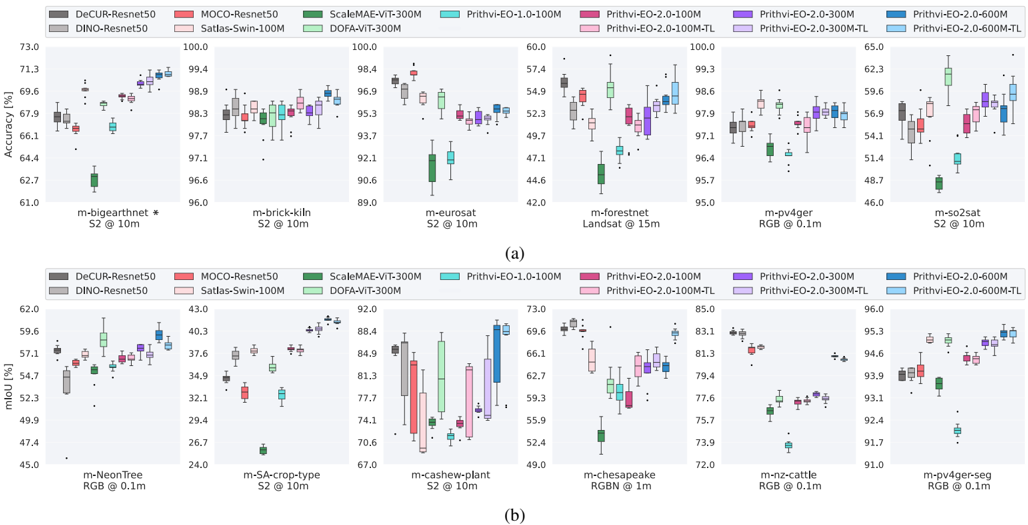
- On GEO-Bench, Prithvi-EO-2.0-600M-TL and Prithvi-EO-2.0-600M achieved the best combined performance across all 12 datasets; all Prithvi-EO-2.0 versions outperformed Prithvi-EO-1.0, with up to 8% improvement overall and a 3% overall gain for the 100M model over its predecessor.
- Downstream gains include Sen1Floods11 water IoU 83.1 for Prithvi-EO-2.0-600M-TL vs. 79.6 for Prithvi-EO-1.0-100M; wildfire burn-scar IoU 83.2 vs. 76.8; L4S landslide mIoU 67.0 with only 50 training images for 600M vs. 59.7 for U-Net; US crop segmentation mIoU 50.7 vs. 42.6 for U-Net; and PASTIS 100% mIoU 53.4 vs. 52.9 for U-TAE.
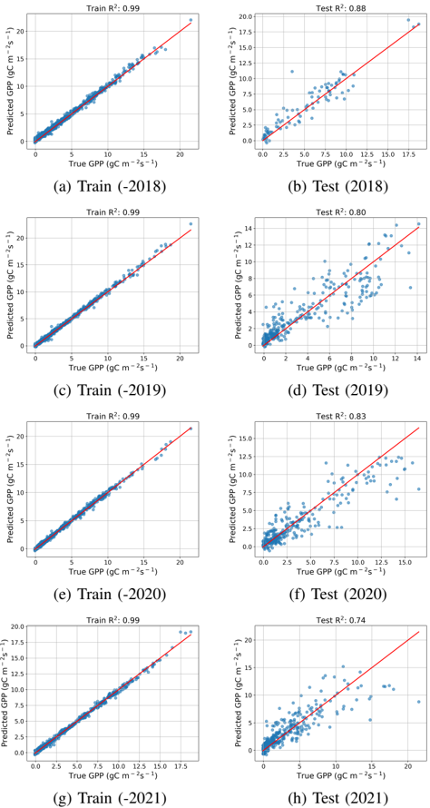
- For AGB estimation, the best Prithvi-EO-2.0-300M configuration reached test RMSE 33.40 with 12 Sentinel-2 timestamps and LoRA, while the baseline achieved 27.49; for GPP, Prithvi-EO-2.0-600M-TL reached R² up to 0.88 in 2018, outperforming random forest, XGBoost, and ResNet18 baselines.
Methods
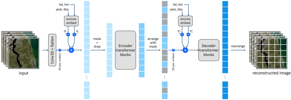
- Pretraining used a masked autoencoder with 3D patch and positional embeddings, plus learned time and location metadata biases with random dropping; models were ViT-L (300M) and ViT-H (600M), trained for 400 epochs on A100 GPUs, using 80 GPUs (~21,000 GPU-hours) for 300M and 240 GPUs (~58,000 GPU-hours) for 600M.
- The pretraining dataset was built from HLS six-band reflectance data (Blue, Green, Red, NIR, SWIR1, SWIR2) spanning 2014–2023, sampled by LULC class and ecoregion, with sequences of four images separated by one to six months, filtered for clouds and missing data, and split into 256×256 patches.
- Evaluation combined GEO-Bench benchmarking across 12 classification and segmentation datasets with 10 hyperparameter trials and 10 random seeds, plus SME-led downstream tasks in disaster response, land cover and crop mapping, and ecosystem dynamics; fine-tuning experiments required a single GPU.
Limitations
- Stated: future work is needed to compare with multimodal GFMs and to identify the benefits and limitations of incorporating additional modalities at the fine-tuning stage.
- Stated: incorporating SAR inputs did not improve biomass estimation in their setting, and adapting Prithvi-EO to SAR is challenging because of fundamental optical–SAR differences; fusing a separate SAR encoder with the pretrained Prithvi encoder could help.
- Evident: pretraining and the main benchmark are optical multispectral HLS/30-m focused, some GEO-Bench datasets lack temporal and location information, and the combined GEO-Bench score averages heterogeneous metrics (accuracy, F1, mIoU) into a single aggregate.
Model-written summary. Check it against the paper before relying on it.
Integrity signals
Registry
Cites
Statistics
Figures




Verification
Claims the paper makes
17 Valid · 9 Not valid · 3 Not checked · 125 Own results and interpretations
The sources with a verdict support this claim; the rest weren’t checked yet, have no full text we could read, or their verdicts aren’t rated yet.
In the paper
“although EO data is inherently multi-temporal, most GFMs do not account for this characteristic.”
What the sources say
- Supportedcites [4] [4] G. Tseng, R. Cartuyvels, I. Zvonkov, M. Purohit, D. Rolnick, and H. Kerner, 'Lightweight, pre-trained transformers for remote sensing timeseries,' 2024, arXiv:2304.14065. - source
The Introduction says current self-supervised remote-sensing approaches treat the data as single-timestep images and therefore cannot use patterns that emerge when an area is monitored over time. This supports the citing sentence’s broad point that geospatial models commonly overlook EO data’s temporal character. (LLM, conf=0.88)
- Not checked — no full text of the sourcecites [5] [5] I. Dumeur, S. Valero, and J. Inglada, 'Self-supervised spatio-temporal representation learning of satellite image time series,' IEEE J. Sel. Topics Appl. Earth Observ. Remote Sens., 2024. - source
plain- Asserted: passes — The authors put it forward as true.
- Checkable: passes — It can be checked against evidence.
- Load-bearing: passes — The paper’s conclusions depend on it.
- Based: passes — The paper gives a reason why it holds.
- Supported
The sources with a verdict support this claim; the rest weren’t checked yet, have no full text we could read, or their verdicts aren’t rated yet.
In the paper
“Those that do either process only point data or focus on long time series restricted to small patches or individual pixels [4], [5].”
What the sources say
- Supportedcites [4] [4] G. Tseng, R. Cartuyvels, I. Zvonkov, M. Purohit, D. Rolnick, and H. Kerner, 'Lightweight, pre-trained transformers for remote sensing timeseries,' 2024, arXiv:2304.14065. - source
Section 3.1 (page unavailable) describes Presto’s 12-month pixel time series and says it receives single-pixel inputs. The Discussion & Conclusion (page unavailable) likewise identifies Presto as a pixel-timeseries model, supporting its use as an example of a multi-temporal model focused on individual pixels. (LLM, conf=0.88)
- Not checked — no full text of the sourcecites [5] [5] I. Dumeur, S. Valero, and J. Inglada, 'Self-supervised spatio-temporal representation learning of satellite image time series,' IEEE J. Sel. Topics Appl. Earth Observ. Remote Sens., 2024. - source
plain- Asserted: passes — The authors put it forward as true.
- Checkable: passes — It can be checked against evidence.
- Load-bearing: passes — The paper’s conclusions depend on it.
- Based: passes — The paper gives a reason why it holds.
- Supported
Every source the paper cites for this claim was checked and supports it.
In the paper
“GEO-Bench offers a carefully curated collection of six classification and six semantic segmentation datasets [10], encompassing a range of spatial resolutions and domains (see Table I).”
What the sources say
- Supportedcites [10] [10] A. Lacoste et al., 'Geo-bench: Toward foundation models for earth monitoring,' Advances in Neural Information Processing Systems, vol. 36, pp. 51 080-51 093, 2023. - source
The Introduction states that GEO-Bench comprises six image-classification and six semantic-segmentation tasks curated by domain experts for diversity. Table 1 in the Diversity of Tasks section lists the twelve datasets and shows differing spatial resolutions and application domains. (LLM, conf=0.94)
plain- Asserted: passes — The authors put it forward as true.
- Checkable: passes — It can be checked against evidence.
- Load-bearing: passes — The paper’s conclusions depend on it.
- Based: passes — The paper gives a reason why it holds.
- Supported
The cited sources support only part of this claim — read each source’s verdict below.
In the paper
“Through extensive benchmarking with GEO-Bench, the model outperforms the previous PrithviEO model by 8% across a range of tasks.”
What the sources say
- Partly supportedcites [10] [10] A. Lacoste et al., 'Geo-bench: Toward foundation models for earth monitoring,' Advances in Neural Information Processing Systems, vol. 36, pp. 51 080-51 093, 2023. - sourceExperimental — accuracy not yet measured
Section 3 identifies GEO-Bench as a benchmark with six classification and six segmentation tasks, supporting its use as a benchmark across tasks. The experiments passage (Section 6.2.2; page unavailable) discusses other model baselines, but our copy does not report a Prithvi-EO-2.0 versus Prithvi-EO comparison or an 8% improvement; searches for those models and the figure found none. (LLM, conf=0.85)
plainstates a cause- Asserted: passes — The authors put it forward as true.
- Checkable: passes — It can be checked against evidence.
- Load-bearing: passes — The paper’s conclusions depend on it.
- Based: passes — The paper gives a reason why it holds.
- Partly supported
The sources with a verdict support this claim; the rest weren’t checked yet, have no full text we could read, or their verdicts aren’t rated yet.
In the paper
“For segmentation, Prithvi-EO-2.0-600M-TL and Prithvi-EO-2.0-600M show the highest performance, with a noticeable margin over the next best models, DeCUR [7] and DINO [12] ResNets.”
What the sources say
- Supportedcites [7] [7] Y. Wang, C. M. Albrecht, N. A. A. Braham, C. Liu, Z. Xiong, and X. X. Zhu, 'Decoupling common and unique representations for multimodal self-supervised learning,' in 18th European Conf. on Comput. Vis. (ECCV) 2024. Springer, 2024, pp. 1-19. - source
The citation is attached to DeCUR, identifying the model rather than sourcing the comparison with Prithvi. Sections 5.2 and 5.3 evaluate DeCUR on semantic segmentation tasks, and Section 5.3 describes transferring a ResNet50 backbone. (LLM, conf=0.91)
- Not checked — no full text of the sourcecites [12] [12] Y. Wang, N. A. A. Braham, Z. Xiong, C. Liu, C. M. Albrecht, and X. X. Zhu, 'Ssl4eo-s12: A large-scale multimodal, multitemporal dataset for self-supervised learning in earth observation [software and data sets],' IEEE Geosci. Remote Sens. Mag., vol. 11, no. 3, pp. 98-106, 2023. - source
plainstates an association- Asserted: passes — The authors put it forward as true.
- Checkable: passes — It can be checked against evidence.
- Load-bearing: passes — The paper’s conclusions depend on it.
- Based: passes — The paper gives a reason why it holds.
- Supported
69 more claims · 6 with their cited sources checked
Create a free account to see all 154 claims and every source verdict.
- Probably not a substantial claim. 38
- It may state two separate claims as one. 56
- The quote only partly states this claim. 3
Self-check
Percentages, sums and reported differences re-computed from the paper’s own numbers.
Each contradiction between two passages listed here was confirmed by an independent check.
Rated minor: it would not touch a result — a value no result rests on, a p-value that stays on the same side of the significance level, or a conflict that is clerical, resolved elsewhere in the paper, or outside its own findings.
In the paper
§ D. Ecosystem dynamics · p. 16
“The PrithviEO-2.0-600M-TL version achieved the highest scores among all models across all testing years.”
§ D. Ecosystem dynamics · p. 16
“| ResNet18 | 0.76 | 0.81 | 0.73 | 0.70 | | Prithvi-EO-2.0-300M | 0.84 | 0.77 | 0.77 | 0.70 | | Prithvi-EO-2.0-300M-TL | 0.84 | 0.76 | 0.74 | 0.69 | | Prithvi-EO-2.0-600M | 0.75 | 0.77 | 0.80 | 0.70 | | Prithvi-EO-2.0-600M-TL | 0.88 | 0.80 | 0.83 | 0.74 |”
Citations
Cites
Vaswani, A., Shazeer, N., Parmar, N., Uszkoreit, J., Jones, L., Gomez, A. N., Kaiser, L., & Polosukhin, I. (2017) · arXiv · doi:10.48550/arxiv.1706.03762 · Cited by 120,404 · cited 16×
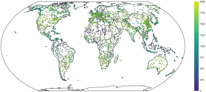
“The resulting pretraining dataset includes 4.2M training and 46k validation samples, which are visualized in Figure 2.”
InfluentialU-Net: Convolutional Networks for Biomedical Image Segmentation
Ronneberger, O., Fischer, P., & Brox, T. (2015) · Lecture notes in computer science · doi:10.1007/978-3-319-24574-4_28 · Cited by 99,404 · cited 1×
“For classification tasks, all models were paired with a linear layer, while we used a U-Net architecture [16] for ResNets and UPerNet [17] decoder for transformer-based architectures, which represent the most adopted choices for these types of architectures.”
Exploiting Generative AI to Scale up Intelligent Tutoring Systems
Jakubův, J., Chvalovský, K., Goertzel, Z., Kaliszyk, C., Olšák, M., Piotrowski, B., Schulz, S., Suda, M., & Urban, J. (2023) · DROPS (Schloss Dagstuhl – Leibniz Center for Informatics) · doi:10.4230/lipics.itp.2023.19 · Cited by 76,658
An Image is Worth 16x16 Words: Transformers for Image Recognition at Scale
Dosovitskiy, A., Beyer, L., Kolesnikov, A., Weissenborn, D., Zhai, X., Unterthiner, T., Dehghani, M., Minderer, M., Heigold, G., Gelly, S., et al. (2020) · arXiv · doi:10.48550/arxiv.2010.11929 · Cited by 47,472
U-Net: Convolutional Networks for Biomedical Image SegmentationPreprint
Ronneberger, O., Fischer, P., & Brox, T. (2015) · arXiv (Cornell University) · doi:10.48550/arxiv.1505.04597 · Cited by 17,820
LoRA: Low-Rank Adaptation of Large Language Models
Hu, E. J., Shen, Y., Wallis, P., Allen-Zhu, Z., Li, Y., Wang, S., Wang, L., & Chen, W. (2021) · arXiv · doi:10.48550/arxiv.2106.09685 · Cited by 13,453 · cited 1×
“0-600M with temporal and location embeddings of 3.5 points on the IoU for the water class.”
InfluentialSelf-citationUNet++: A Nested U-Net Architecture for Medical Image Segmentation
Zhou, Z., Rahman Siddiquee, M. M., Tajbakhsh, N., & Liang, J. (2018) · Lecture Notes in Computer Science · doi:10.1007/978-3-030-00889-5_1 · Cited by 9,610 · cited 1×
“For a comparative study on the landslide mapping task, U-Net [28] and U-Net++ [29] were employed.”
Masked Autoencoders Are Scalable Vision Learners
He, K., Chen, X., Xie, S., Li, Y., Dollar, P., & Girshick, R. (2022) · 2022 IEEE/CVF Conference on Computer Vision and Pattern Recognition (CVPR) · doi:10.1109/cvpr52688.2022.01553 · Cited by 8,489 · cited 4×
“Positional embeddings are added to the full set of tokens and sent to the decoder’s series of transformer blocks to perform the image reconstruction task [9].”
InfluentialSGDR: Stochastic Gradient Descent with Warm Restarts
Loshchilov, I., & Hutter, F. (2016) · arXiv · doi:10.48550/arxiv.1608.03983 · Cited by 5,309
ViViT: A Video Vision Transformer
Arnab, A., Dehghani, M., Heigold, G., Sun, C., Lucic, M., & Schmid, C. (2021) · 2021 IEEE/CVF International Conference on Computer Vision (ICCV) · doi:10.1109/iccv48922.2021.00676 · Cited by 2,767 · cited 1×
“A full list can be found in Table 3 Table 3”
Unified Perceptual Parsing for Scene UnderstandingPreprint
Xiao, T.-T., Liu, Y., Zhou, B.-L., Jiang, Y.-N., & Sun, J. (2018) · European Conference on Computer Vision · doi:10.48550/arxiv.1807.10221 · Cited by 2,735
On the Opportunities and Risks of Foundation Models
Bommasani, R., Hudson, D. A., Adeli, E., Altman, R., Arora, S., von Arx, S., Bernstein, M. S., Bohg, J., Bosselut, A., Brunskill, E., et al. (2021) · arXiv · doi:10.48550/arxiv.2108.07258 · Cited by 2,676
Self-citationAn ecoregion-based approach to protecting half the terrestrial realm
Dinerstein, E., Olson, D., Joshi, A., Vynne, C., Burgess, N. D., Wikramanayake, E., Hahn, N., Palminteri, S., Hedao, P., Noss, R., et al. (2017) · BioScience · doi:10.1093/biosci/bix014 · Cited by 2,460 · cited 1×
“First, we began by calculating the proportion of LULC classes and ecoregions for each HLS tile using the Coper-nicus Land Cover 100m [7] and RESOLVE Ecoregions [8] labels.”
Unified Perceptual Parsing for Scene Understanding
Xiao, T., Liu, Y., Zhou, B., Jiang, Y., & Sun, J. (2018) · Lecture Notes in Computer Science · doi:10.1007/978-3-030-01228-1_26 · Cited by 2,201 · cited 3×
“For all models, we have used an UPerNet [17] head decoder and ran hyperparameter tuning with terratorch (10 trials, tuning weight decay and learning rate).”
The FLUXNET2015 dataset and the ONEFlux processing pipeline for eddy covariance data
Pastorello, G., Trotta, C., Canfora, E., Chu, H., Christianson, D., Cheah, Y.-W., Poindexter, C., Chen, J., Elbashandy, A., Humphrey, M., et al. (2020) · Scientific Data · doi:10.1038/s41597-020-0534-3 · Cited by 1,728 · cited 1×
“We utilize daily GPP data from eddy covariance flux towers, obtained from FLUXNET [40], AmeriFlux 10 , and ICOS [41] networks.”
The Harmonized Landsat and Sentinel-2 surface reflectance data set
Claverie, M., Ju, J., Masek, J. G., Dungan, J. L., Vermote, E. F., Roger, J.-C., Skakun, S. V., & Justice, C. (2018) · Remote Sensing of Environment · doi:10.1016/j.rse.2018.09.002 · Cited by 1,497 · cited 1×
“The HLS data [6] is the harmonized surface reflectance data product from NASA/USGS’s Landsat 8 and 9 and the ESA’s Sentinel-2A and Sentinel-2B satellites.”
Berman, M., Triki, A. R., & Blaschko, M. B. (2018) · 2018 IEEE/CVF Conference on Computer Vision and Pattern Recognition · doi:10.1109/cvpr.2018.00464 · Cited by 1,027 · cited 1×
“The model was fine-tuned with two different loss functions: weighted cross-entropy (wCE) loss, with a weighted ratio of 2:8 for negative and positive pixels, and Lovasz loss [26].”
VideoMAE: Masked Autoencoders are Data-Efficient Learners for Self-Supervised Video Pre-Training
Tong, Z., Song, Y., Wang, J., & Wang, L. (2022) · arXiv · doi:10.48550/arxiv.2203.12602 · Cited by 909
Copernicus Global Land Cover Layers—Collection 2
Buchhorn, M., Lesiv, M., Tsendbazar, N.-E., Herold, M., Bertels, L., & Smets, B. (2020) · Remote Sensing · doi:10.3390/rs12061044 · Cited by 884
Jung, M., Schwalm, C., Migliavacca, M., Walther, S., Camps-Valls, G., Koirala, S., Anthoni, P., Besnard, S., Bodesheim, P., Carvalhais, N., et al. (2020) · Biogeosciences · doi:10.5194/bg-17-1343-2020 · Cited by 866
How eddy covariance flux measurements have contributed to our understanding of Global Change Biology
Baldocchi, D. D. (2020) · Global Change Biology · doi:10.1111/gcb.14807 · Cited by 581 · cited 1×
“A full list can be found in Table 3 Table 3”
Representativeness of Eddy-Covariance flux footprints for areas surrounding AmeriFlux sites
Chu, H., Luo, X., Ouyang, Z., Chan, W. S., Dengel, S., Biraud, S. C., Torn, M. S., Metzger, S., Kumar, J., Arain, M. A., et al. (2021) · Agricultural and Forest Meteorology · doi:10.1016/j.agrformet.2021.108350 · Cited by 497 · cited 1×
“0-600M with temporal and location embeddings is of 5.6 points.”
InfluentialMasked Autoencoders As Spatiotemporal Learners
Feichtenhofer, C., Fan, H., Li, Y., & He, K. (2022) · arXiv · doi:10.48550/arxiv.2205.09113 · Cited by 345
SatMAE: Pre-training Transformers for Temporal and Multi-Spectral Satellite Imagery
Cong, Y., Khanna, S., Meng, C., Liu, P., Rozi, E., He, Y., Burke, M., Lobell, D. B., & Ermon, S. (2022) · arXiv · Cited by 323
SatMAE: Pre-Training Transformers for Temporal and Multi-Spectral Satellite Imagery
Cong, Y., Khanna, S., Meng, C., Liu, P., Rozi, E., He, Y., Burke, M., Lobell, D., & Ermon, S. (2022) · Advances in Neural Information Processing Systems 35 · doi:10.52202/068431-0015 · Cited by 303
Bonafilia, D., Tellman, B., Anderson, T., & Issenberg, E. (2020) · 2020 IEEE/CVF Conference on Computer Vision and Pattern Recognition Workshops (CVPRW) · doi:10.1109/cvprw50498.2020.00113 · Cited by 295 · cited 1×
“Sen1Floods11 [23] is a surface water data set including labels for water and land, and related Sentinel-1 and Sentinel-2 imagery.”
CORINE Land Cover and Land Cover Change Products
Büttner, G. (2014) · Remote Sensing and Digital Image Processing · doi:10.1007/978-94-007-7969-3_5 · Cited by 284 · cited 1×
“…is particularly interesting because these tasks focus on earth observation applications like land use classification using the CORINE Land Cover [22], which has strong focus on environmental monitoring categories (e.g. agriculture-and forest-related especially), and crop classification, which…”
Masked Autoencoders as Spatiotemporal Learners
Feichtenhofer, C., Fan, H., Li, Y., & He, K. (2022) · neural information processing systems · doi:10.52202/068431-2605 · Cited by 273
UNet++: A Nested U-Net Architecture for Medical Image SegmentationPreprint
Zhou, Z., Siddiquee, M. M. R., Tajbakhsh, N., et al. (2018) · arXiv (Cornell University) · doi:10.48550/arxiv.1807.10165 · Cited by 267
Panoptic Segmentation of Satellite Image Time Series with Convolutional Temporal Attention Networks
Fare Garnot, V. S., & Landrieu, L. (2021) · 2021 IEEE/CVF International Conference on Computer Vision (ICCV) · doi:10.1109/iccv48922.2021.00483 · Cited by 242 · cited 1×
“This model is based on a U-Net architecture with temporal attention encoding [35], using all 12 time steps and all 15 channels from Sentinel-1 and Sentinel-2 imagery as inputs for each yearly AGB prediction.”
Scale-MAE: A Scale-Aware Masked Autoencoder for Multiscale Geospatial Representation Learning
Reed, C. J., Gupta, R., Li, S., Brockman, S., Funk, C., Clipp, B., Keutzer, K., Candido, S., Uyttendaele, M., & Darrell, T. (2023) · 2023 IEEE/CVF International Conference on Computer Vision (ICCV) · doi:10.1109/iccv51070.2023.00378 · Cited by 241 · cited 1×
“The pretraining process of our foundation model is based on the masked autoencoder (MAE) approach [9], a self-supervised learning method widely used and extended for different data types, including video [10] and multi-spectral images [11, 12].”
Tuia, D., Schindler, K., Demir, B., Zhu, X. X., Kochupillai, M., Džeroski, S., van Rijn, J. N., Hoos, H. H., Frate, F. D., Datcu, M. P., et al. (2024) · IEEE Geoscience and Remote Sensing Magazine · doi:10.1109/mgrs.2024.3425961 · Cited by 206
GEO-Bench: Toward Foundation Models for Earth Monitoring
Lacoste, A., Lehmann, N., López, P. R., et al. (2023) · Neural Information Processing Systems · doi:10.48550/arxiv.2306.03831 · Cited by 180
d’Andrimont, R., Yordanov, M., Martinez-Sanchez, L., Eiselt, B., Palmieri, A., Dominici, P., Gallego, J., Reuter, H. I., Joebges, C., Lemoine, G., et al. (2020) · Scientific Data · doi:10.1038/s41597-020-00675-z · Cited by 176 · cited 1×
“Sen4Map comprises 335,125 time series of 64 × 64 pixels multispectral patches, extracted from Sentinel-2 tiles and annotated with geolocated land-cover data collected through extensive in situ surveys using LUCAS points [34].”
Lightweight Temporal Self-attention for Classifying Satellite Images Time Series
Garnot, V. S. F., & Landrieu, L. (2020) · Lecture notes in computer science · doi:10.1007/978-3-030-65742-0_12 · Cited by 168
Alvarez, D. (2021) · Journal of large-scale research facilities JLSRF · doi:10.17815/jlsrf-7-183 · Cited by 167 · cited 1×
“The models were pretrained on the Booster partition of the JUWELS (Jülich Wizard for European Leadership Science) supercomputer 3 [15] hosted at JSC, which features 936 compute nodes, each equipped with 4 NVIDIA A100 GPUs.”
SatlasPretrain: A Large-Scale Dataset for Remote Sensing Image Understanding
Bastani, F., Wolters, P., Gupta, R., Ferdinando, J., & Kembhavi, A. (2023) · 2023 IEEE/CVF International Conference on Computer Vision (ICCV) · doi:10.1109/iccv51070.2023.01538 · Cited by 158 · cited 2×
“0-600M with temporal and location embeddings of 3.5 points on the IoU for the water class.”
InfluentialGhorbanzadeh, O., Xu, Y., Zhao, H., Wang, J., Zhong, Y., Zhao, D., Zang, Q., Wang, S., Zhang, F., Shi, Y., et al. (2022) · IEEE Journal of Selected Topics in Applied Earth Observations and Remote Sensing · doi:10.1109/jstars.2022.3220845 · Cited by 157 · cited 2×
“It includes 14 data layers: Sentinel-2 multispectral bands (B1–B12), a digital elevation model (DEM), and slope data from ALOS PALSAR [25].”
Self-citationFoundation Models for Generalist Geospatial Artificial Intelligence
Jakubik, J., Roy, S., Phillips, C. E., Fraccaro, P., Godwin, D., Zadrozny, B., Szwarcman, D., Gomes, C., Nyirjesy, G., Edwards, B., et al. (2023) · arXiv · Cited by 157 · cited 5×
“0 against six of the most popular and performant EO foundation models recently released (see Table 2), as well as the earlier version of Prithvi trained on the US only released last year [4].”
InfluentialSelf-citationWang, Y., Braham, N. A. A., Xiong, Z., Liu, C., Albrecht, C. M., & Zhu, X. X. (2023) · IEEE Geoscience and Remote Sensing Magazine · doi:10.1109/mgrs.2023.3281651 · Cited by 141 · cited 1×
“4 : Examples of images and labels for the GEO-Bench datasets [5]. the leaderboard with some margin on DeCUR [19] and DINO [18] ResNets.”
A constraint on historic growth in global photosynthesis due to rising CO2
Keenan, T. F., Luo, X., Stocker, B. D., De Kauwe, M. G., Medlyn, B. E., Prentice, I. C., Smith, N. G., Terrer, C., Wang, H., Zhang, Y., et al. (2023) · Nature Climate Change · doi:10.1038/s41558-023-01867-2 · Cited by 138 · cited 1×
“Photosynthesis (Gross Primary Productivity (GPP)), the critical process converting solar radiation into energy and materials that sustain life, represents the largest global carbon cycle flux, yet remains challenging to quantify accurately without direct observation [36].”
Self-citationNelson, J. A., Walther, S., Gans, F., Kraft, B., Weber, U., Novick, K., Buchmann, N., Migliavacca, M., Wohlfahrt, G., Šigut, L., et al. (2024) · Biogeosciences · doi:10.5194/bg-21-5079-2024 · Cited by 136 · cited 1×
“0-600M with temporal and location embeddings is of 5.6 points.”
InfluentialWarm Winter 2020 Team, & ICOS Ecosystem Thematic Centre (2020) · ICOS Carbon Portal · doi:10.18160/2g60-zhak · Cited by 120
Shao, Z., & Zhang, L. (2016) · Sensors · doi:10.3390/s16060834 · Cited by 105 · cited 1×
“0-600M with temporal and location embeddings is of 5.6 points.”
InfluentialBerman, M., Triki, A. R., & Blaschko, M. B. (2017) · arXiv (Cornell University) · doi:10.48550/arxiv.1705.08790 · Cited by 65
Decoupling Common and Unique Representations for Multimodal Self-supervised Learning
Wang, Y., Albrecht, C. M., Braham, N. A. A., Liu, C., Xiong, Z., & Zhu, X. X. (2025) · Lecture Notes in Computer Science · doi:10.1007/978-3-031-73397-0_17 · Cited by 49 · cited 1×
“4 : Examples of images and labels for the GEO-Bench datasets [5]. the leaderboard with some margin on DeCUR [19] and DINO [18] ResNets.”
GEO-Bench: Toward Foundation Models for Earth Monitoring
Lacoste, A., Lehmann, N., Rodriguez, P., Sherwin, E., Kerner, H., Lütjens, B., Irvin, J., Dao, D., Alemohammad, H., Drouin, A., et al. (2023) · Advances in Neural Information Processing Systems 36 · doi:10.52202/075280-2223 · Cited by 40
Self-citationAssessment of a new GeoAI foundation model for flood inundation mapping
Li, W., Lee, H., Wang, S., Hsu, C.-Y., & Arundel, S. T. (2023) · arXiv · doi:10.48550/arxiv.2309.14500 · Cited by 40
Self-citationAssessment of a new GeoAI foundation model for flood inundation mapping
Li, W., Lee, H., Wang, S., Hsu, C.-Y., & Arundel, S. T. (2023) · Proceedings of the 6th ACM SIGSPATIAL International Workshop on AI for Geographic Knowledge Discovery · doi:10.1145/3615886.3627747 · Cited by 39 · cited 1×
“A full list can be found in Table 3 Table 3”
Self-citationSelf-Supervised Spatio-Temporal Representation Learning of Satellite Image Time Series
Dumeur, I., Valero, S., & Inglada, J. (2024) · IEEE Journal of Selected Topics in Applied Earth Observations and Remote Sensing · doi:10.1109/jstars.2024.3358066 · Cited by 39
Lightweight, Pre-trained Transformers for Remote Sensing Timeseries
Tseng, G., Cartuyvels, R., Zvonkov, I., Purohit, M., Rolnick, D., & Kerner, H. (2023) · arXiv · doi:10.48550/arxiv.2304.14065 · Cited by 37
Neural Plasticity-Inspired Multimodal Foundation Model for Earth Observation
Xiong, Z., Wang, Y., Zhang, F., Stewart, A. J., Hanna, J., Borth, D., Papoutsis, I., Saux, B. L., Camps-Valls, G., & Zhu, X. X. (2024) · arXiv · doi:10.48550/arxiv.2403.15356 · Cited by 26 · cited 1×
“These figures highlight that, for the classification tasks, DOFA [20] comes first, with Prithvi-EO-2.”
Kang, Y., Bassiouni, M., Gaber, M., Lu, X., & Keenan, T. F. (2025) · Earth System Science Data · doi:10.5194/essd-17-3009-2025 · Cited by 22 · cited 2×
“However, these approaches face challenges due to scale mismatches between in-situ measurements and satellite data, as well as generalization issues, which could potentially be mitigated by using foundation models like Prithvi that embed generalized representations of high-resolution data [39].”
Self-citationSharma, S., Sedona, R., Riedel, M., Cavallaro, G., & Paris, C. (2024) · IEEE Journal of Selected Topics in Applied Earth Observations and Remote Sensing · doi:10.1109/jstars.2024.3435081 · Cited by 19 · cited 2×
“Table 10 : Mean F1 score and std for the land cover classification, fine-tuning the models on fractions of the original dataset, compared to baseline ViViT [33].”
Self-citationLing, Y., Wang, Y., Lin, Y., et al. (2024) · IEEE Geoscience and Remote Sensing Letters · doi:10.1109/lgrs.2024.3454319 · Cited by 12 · cited 1×
“These are popular and powerful models that have been used to support a wide range of environmental mapping tasks, including landslide mapping [30–32].”
Terrestrial carbon and water flux products from an extended data-driven scaling framework, FLUXCOM-X
Nelson, J. A., Walther, S., Kraft, B., Gans, F., Duveiller, G., Weber, U., Hamdi, Z. M., Zhang, W., Jung, M., & Contributors, F. (2025) · EGU General Assembly Conference Abstracts · doi:10.5194/egusphere-egu24-16573 · Cited by 8
Nascetti, A., Yadav, R., Brodt, K., Qu, Q., Fan, H., Shendryk, Y., Shah, I., & Chung, C. (2023) · Advances in Neural Information Processing Systems 36 · doi:10.52202/075280-0896 · Cited by 7
Self-Supervised Spatio-Temporal Representation Learning of Satellite Image Time Series
Dumeur, I., Valero, S., & Inglada, J. (2023) · IEEE International Geoscience and Remote Sensing Symposium (IGARSS) · doi:10.1109/igarss52108.2023.10281412 · Cited by 4
Lightweight Temporal Self-Attention for Classifying Satellite Image Time SeriesPreprint
Garnot, V. S. F., & Landrieu, L. (2020) · arXiv (Cornell University) · doi:10.48550/arxiv.2007.00586 · Cited by 2
A constraint on historic growth in global photosynthesis due to rising CO2
Keenan, T. F., Luo, X., Stocker, B. D., Kauwe, M. G. D., Medlyn, B. E., Prentice, I. C., Smith, N. G., Terrer, C., Wang, H., Zhang, Y., et al. (2023) · doi:10.48350/196558
Self-citationChu, H., Luo, X., Ouyang, Z., Chan, S., Dengel, S., Biraud, S. C., Torn, M. S., Metzger, S., Jitendra Kumar, A., Arain, M. A., et al. (2020) · Zenodo (CERN European Organization for Nuclear Research) · doi:10.5281/zenodo.4015349
Jung, M., Schwalm, C., Migliavacca, M., et al. (2019) · doi:10.5194/bg-2019-368
Research works printed but not linked: 2
- [25] C. Napper, Burned area emergency response treatments catalog. US Forest Service, San Dimas Technology and Development Center, 2006. -
- [40] V. S. F. Garnot and L. Landrieu, 'Panoptic Segmentation of Satellite Image Time Series With Convolutional Temporal Attention Networks,' in Proceedings of the IEEE/CVF International Conference on Computer Vision, 2021, pp. 4872-4881. -
Cited by
The spread of non‐native species
Haubrock, P. J., Tarkan, A. S., Martín‐Forés, I., Katsanevakis, S., Sousa, R., Soto, I., Green, A. J., Kouba, A., Everts, T., Almela, V. D., et al. (2025) · Biological reviews/Biological reviews of the Cambridge Philosophical Society · doi:10.1002/brv.70121 · Cited by 44
Bai, L., Zhang, X., Qin, W., Long, J., Wang, H., Dong, X., & Du, S. (2025) · IEEE Geoscience and Remote Sensing Magazine · doi:10.1109/mgrs.2025.3588505 · Cited by 10
“0 [ 217], and A 2 -MAE [208] embed the RS location coordinates into the model training, attempting to use such a priori information to guide the model learning.”
Digital soil mapping in the era of big data and artificial Intelligence
Lin, Y., & Li, X. (2026) · Annals of GIS · doi:10.1080/19475683.2026.2665149 · Cited by 6
Longépé, N., Alemohammad, H., Anghelea, A., et al. (2025) · IEEE Geoscience and Remote Sensing Magazine · doi:10.1109/mgrs.2025.3592035 · Cited by 3
“0 [29] demonstrated a well-defined embedding space for land use/land cover classes and change detection tasks (e.g., burn scars), while PANGEA results showed that U-Net architectures with frozen backbones still outperform many general-purpose FMs, although this is not the case for the TerraMind…”
Self-citationFARM: Crop Yield Prediction via Regression on Prithvi’s Encoder for Satellite Sensing
Nejadshamsi, S., Zhang, Y., Porth, B., Zaki, S., Porth, L., & Khoshdel, V. (2026) · AgriEngineering · doi:10.3390/agriengineering8010002 · Cited by 6
“0-600M, are pre-trained on global satellite archives and provide generalizable representations that can be fine-tuned for downstream tasks, including agricultural prediction [25].”
Metadata
- Authors
- Szwarcman, D., Roy, S., Fraccaro, P., Gislason, T. E., Blumenstiel, B., Ghosal, R., de Oliveira, P. H., de Sousa Almeida, J. L., Sedona, R., Kang, Y., Chakraborty, S., Wang, S., Gomes, C., Kumar, A., Gaur, V., Truong, M., Godwin, D., Khallaghi, S., Lee, H., Hsu, C.-Y., Asanjan, A. A., Mujeci, B., Shidham, D., Balogun, R. O., Kolluru, V., Keenan, T., Arevalo, P., Li, W., Alemohammad, H., Olofsson, P., Mayer, T., Hain, C., Kennedy, R., Zadrozny, B., Bell, D., Cavallaro, G., Watson, C., Maskey, M., Ramachandran, R., & Moreno, J. B.
- Affiliations
- IBM (United States) (US)
- Marshall Space Flight Center (US)
- University of Iceland
- University of Alabama in Huntsville (US)
- IBM Research
- Forschungszentrum Jülich (DE)
- Virginia Tech (US)
- Universities Space Research Association (US)
- Arizona State University (US)
- Oregon State University (US)
- Clark University (US)
- University of California, Berkeley (US)
- Boston University
- University of Iceland (IS)
- ORCID
- Szwarcman, Daniela
- Roy, Sujit
- Fraccaro, Paolo
- Sedona, Rocco
- Kang, Yanghui
- Chakraborty, Srija
- Wang, Sizhe
- Kumar, Ankur
- Khallaghi, Sam
- Lee, Hyunho
- Hsu, Chia-Yu
- Asanjan, Ata Akbari
- Balogun, Rufai Omowunmi
- Kolluru, Venkatesh
- Keenan, Trevor
- Arevalo, Paulo
- Li, Wenwen
- Alemohammad, Hamed
- Olofsson, Pontus
- Mayer, Timothy
- Hain, Christopher
- Kennedy, Robert
- Zadrozny, Bianca
- Cavallaro, Gabriele
- Watson, Campbell
- Maskey, Manil
- Ramachandran, Rahul
- Venue
- IEEE Transactions on Geoscience and Remote Sensing
- Published
- 2026
- Volume
- 64
- Pages
- 1-20
- ISSN
- 0196-2892 (ISSN-L)
- 1558-0644
- OpenAlex
- W4417248811
- Semantic Scholar
- ac64dc7cc08ed44f1f0742b86dfd760ddf0578b3
- Cited by
- 100
- References
- 34
- Citations by year
- 2026: 81
- FWCI
- 40.73
- Type
- journal article
- Language
- en
- Open access
- hybrid
- doi.org
- Locations
- IEEE Transactions on Geoscience and Remote Sensing (publishedVersion, cc-by)
- JuSER (Forschungszentrum Jülich) (publishedVersion, other-oa)
- arXiv (Cornell University) (submittedVersion, cc-by)
- arXiv (Cornell University) (cc-by)
- Funders
- National Aeronautics and Space Administration (80MSFC22M004)
- Gauss Centre for Supercomputing e.V
- NASA (80NSSC24K1562)
- Topics
- Physical Sciences › Computer Science › Computer Vision and Pattern Recognition › Remote-Sensing Image Classification
- Physical Sciences › Environmental Science › Ecology › Remote Sensing in Agriculture
- Social Sciences › Geography, Planning and Development › Remote Sensing and Land Use
- Keywords
- geospatial foundation models, Landsat, Sentinel-2, temporal embeddings, location embeddings, high-resolution remote sensing, disaster response, land cover mapping, crop mapping, open-source models
About these checks
Registry, retraction, Cites and statistics results are computed, not judged, with one exception: a printed reference that no index lists is read once by a model before it counts as a citation error. Claims are extracted by a model and kept only when their quote appears verbatim in the text; each cited source is then checked, with a model’s help, for whether it says what the claim relies on. Those verdicts can be wrong — read the claim’s quote and the cited source before relying on one.
The claim verdicts this report counts are experimental: their accuracy is not yet measured.
A language model drew the claims from the paper on 2026-10-29, under version 3 of the claim definition (model deepseek-v4.1-flash, prompt extract-v3).
A second model labelled each claim on 2026-10-29 (model jev-1.13-20260917, definition revision gold-guideline-v0.2).
Cited sources are checked with a language model’s help (gpt-6-sol).
Statistics and arithmetic are recomputed, not judged.
Confidence bands are shown only for fields calibrated on our annotated test set. None is calibrated yet, so no band is shown.
What counts as a claim ›How we measure confidence ›How we check this ›
Are you an author, or do you see a problem with this page? Request a review
Data sources
Bibliographic data: Semantic Scholar, OpenAlex, Crossref.
Contains information from the Semantic Scholar Academic Graph Datasets, made available under the ODC Attribution License (ODC-BY 1.0).
Semantic Scholar’s data is described in: Kinney, R., et al. (2023). The Semantic Scholar Open Data Platform. arXiv:2301.10140.
