

The DOI matches its Crossref record; 163 of the 163 references it cites were found in a registry or an index; none of the 192 sources its claims cite is checked for support yet.
Development of a volcanic risk management system at Mount St. Helens—1980 to present
Open accessAbstract
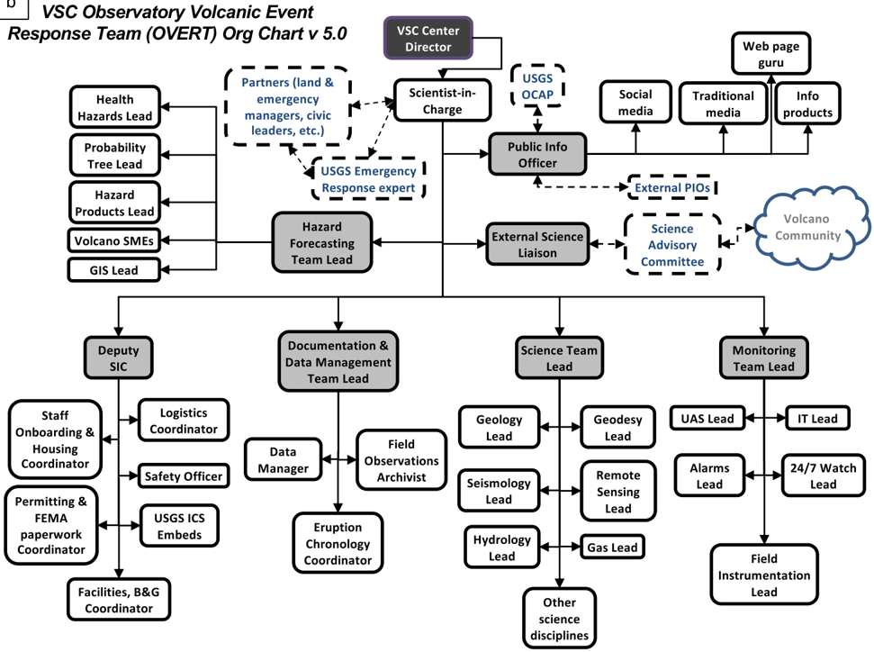
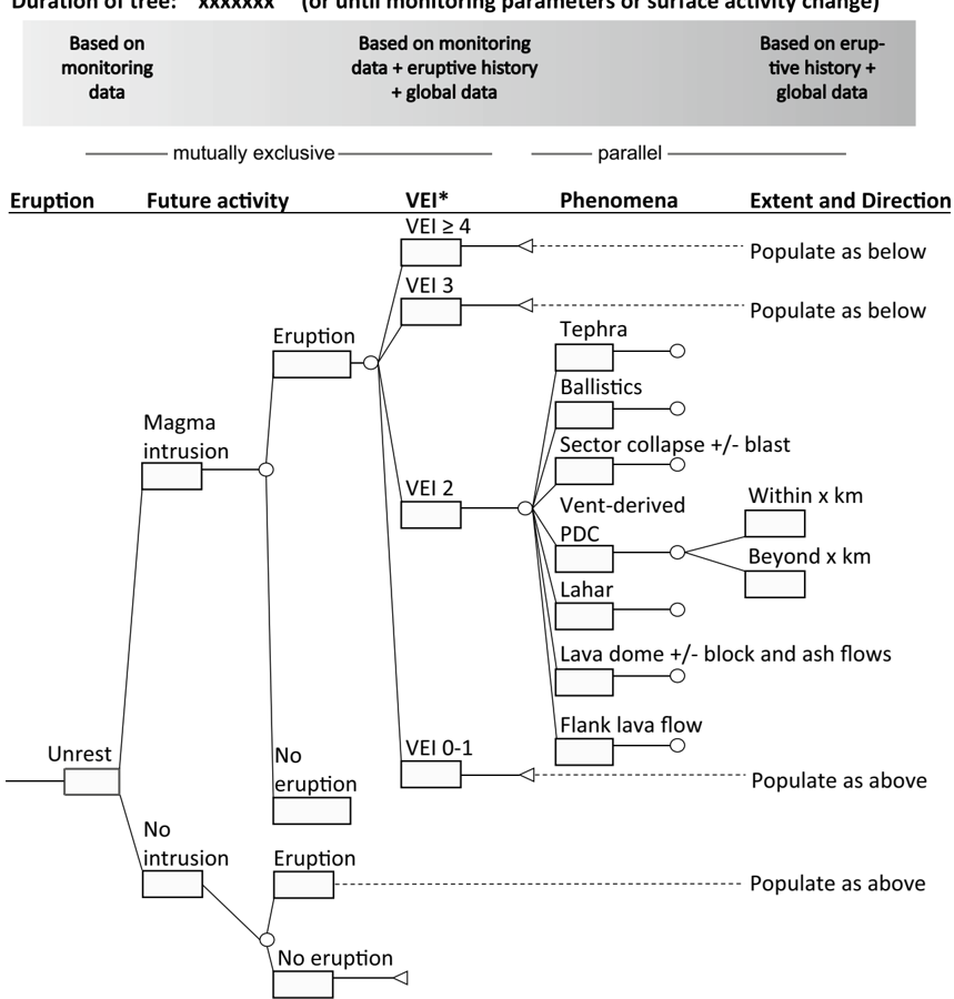
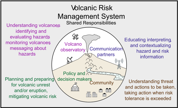
Here, we review volcanic risk management at Mount St. Helens from the perspective of the US Geological Survey’s (USGS) experience over the four decades since its 18 May 1980 climactic eruption. Prior to 1980, volcano monitoring, multidisciplinary eruption forecasting, and interagency coordination for eruption response were new to the Cascade Range. A Mount St. Helens volcano hazards assessment had recently been published and volcanic crisis response capabilities tested during 1975 thermal unrest at nearby Mount Baker. Volcanic unrest began in March 1980, accelerating the rate of advance of volcano monitoring, prompting coordinated eruption forecasting and hazards communication, and motivating emergency response planning. The destruction caused by the 18 May 1980 eruption led to an enormous emergency response effort and prompted extensive coordination and planning for continuing eruptive activity. Eruptions continued with pulsatory dome growth and explosive eruptions over the following 6 years and with transport of sediment downstream over many more. In response, USGS scientists and their partners expanded their staffing, deployed new instruments, developed new tools (including the first use of a volcanic event tree) for eruption forecasting, and created new pathways for agency internal and external communication. Involvement in the Mount St. Helens response motivated the establishment of response measures at other Cascade Range volcanoes. Since assembly during the early and mid-1990s, volcano hazard working groups continue to unite scientists, emergency and land managers, tribal nations, and community leaders in common cause for the promotion of risk reduction. By the onset of renewed volcanic activity in 2004, these new systems enabled a more efficient response that was greatly facilitated by the participation of organizations within volcano hazard working groups. Although the magnitude of the 2004 eruptive sequence was much smaller than that of 1980, a new challenge emerged focused on hazard communication demands. Since 2008, our understanding of Mount St. Helens volcanic system has improved, helping us refine hazard assessments and eruption forecasts. Some professions have worked independently to apply the Mount St. Helens story to their products and services. Planning meetings and working group activities fortify partnerships among information disseminators, policy and decision-makers, scientists, and communities. We call the sum of these pieces the Volcanic Risk Management System (VRMS). In its most robust form, the VRMS encompasses effective production and coordinated exchange of volcano hazards and risk information among all interested parties.
Overview
CoChat Summary
Written by AI from the paper’s full text.
TL;DR
This review traces how volcanic risk management at Mount St. Helens evolved from the 1980 climactic eruption through 2023, arguing that a non-formalized but integrated Volcanic Risk Management System (VRMS) emerged through repeated crises, partnerships, and communication advances. It emphasizes that scientific monitoring and forecasting improved, but long-term engagement, uncertainty communication, and forecasting of collapse, blast, and explosive magnitude remain difficult.
Key findings
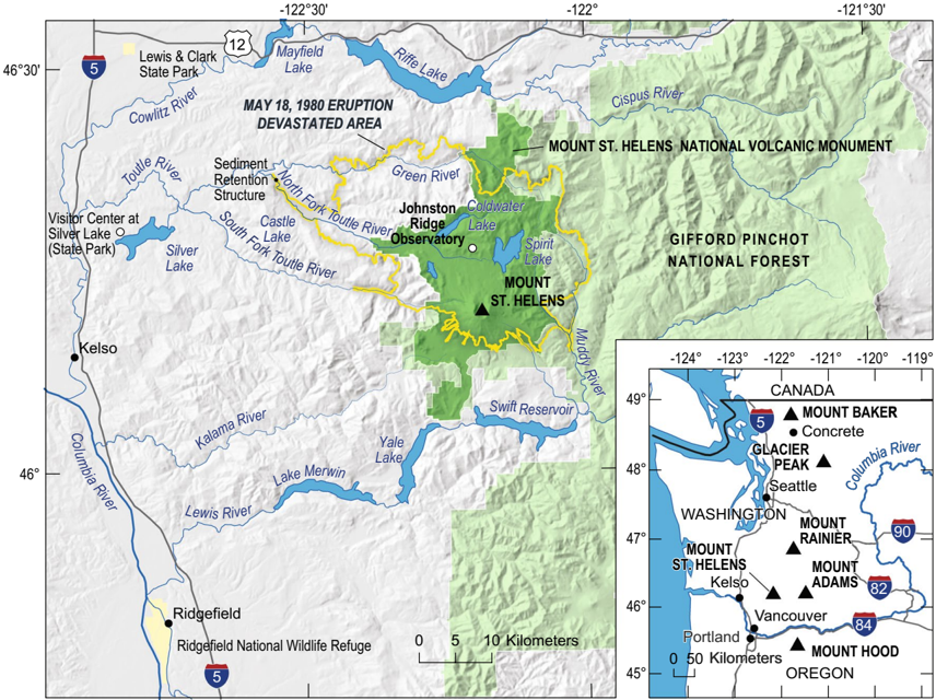
- The 18 May 1980 eruption killed 57 people and caused an estimated $1.1 billion in damages (not inflation-adjusted); the debris avalanche traveled up to 29 km, the lateral blast reached 28 km, the vertical column reached 30 km, and a delayed lahar reached the Columbia River about 120 km away.
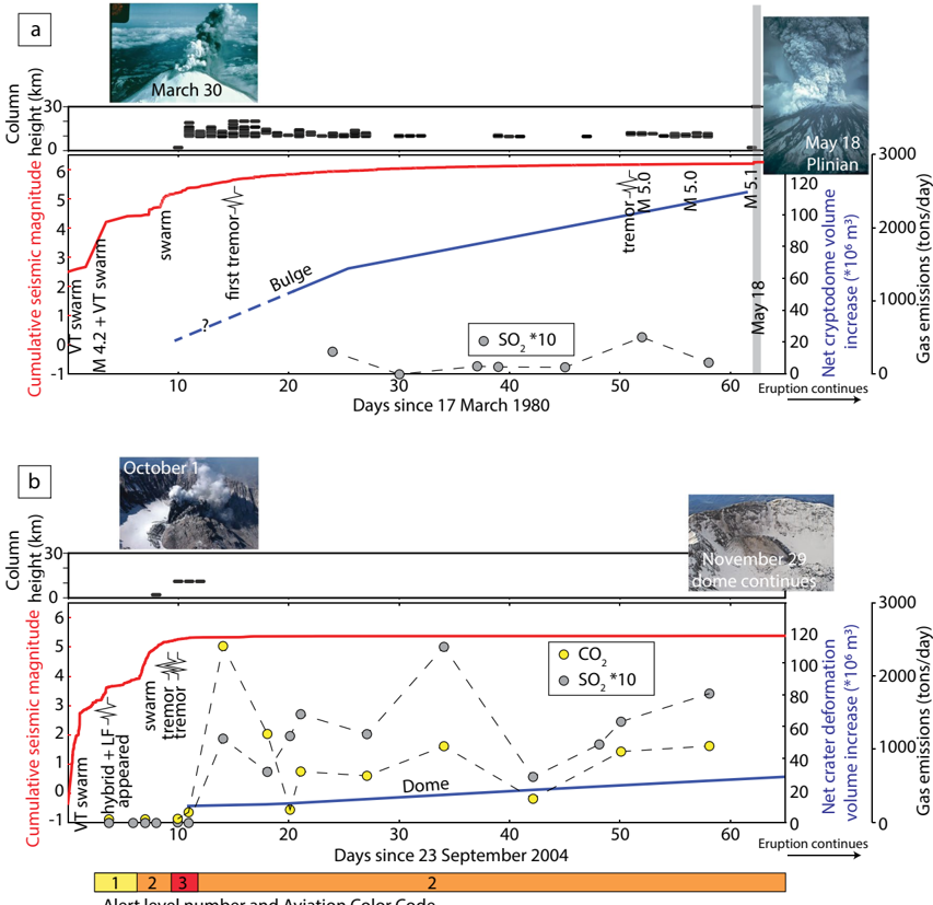
- Forecasting improved after 1980: increasing seismicity, gas emission, and deformation repeatedly preceded dome extrusion and explosions, allowing successful forecasts before all but two dome-building eruptions, though eruption size and style remained hard to forecast.
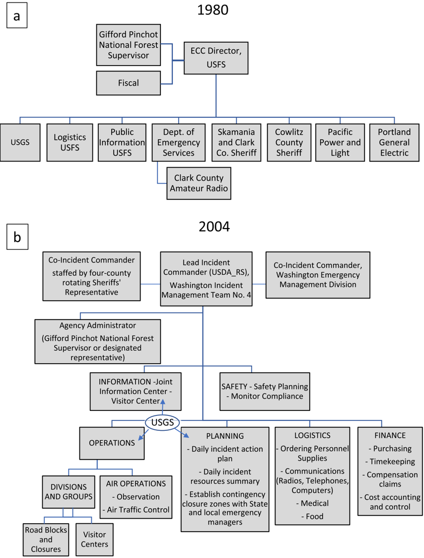
- By 2004, existing monitoring, coordination plans, and volcano hazard working groups enabled a more efficient response; about 2,500 people were evacuated from Johnston Ridge Observatory, and the Joint Information Center handled approximately 800 media inquiries during 3–13 October 2004.
- The paper identifies the VRMS as encompassing scientists, land and emergency managers, tribal nations, schools, parks, news media, and community leaders; since 1995, Cascades Volcano Observatory scientists attended more than 70 comprehensive volcano hazard working group meetings.
Methods
- Narrative review and synthesis of USGS experience at Mount St. Helens over four decades, organized into seven time periods: 1970s, March–May 1980, 18 May 1980, late May 1980–1986, 1986–2004, 2004–2008, and 2008–2023.
- Draws on published scientific literature, agency reports, monitoring records, event trees, hazard assessments, emergency coordination plans, and oral communications with responders, scientists, and communicators.
- Main analysis is qualitative historical synthesis, using Table 1 and figures to trace changes in monitoring, forecasting, hazards communication, education, and emergency management.
Limitations
- The paper’s “Challenges” section states remaining limitations: maintaining monitoring networks, forecasting sector collapse and lateral blasts, forecasting explosive magnitude, forecasting small/phreatic explosions, sustaining long-term multi-agency participation, institutionalizing two-way science communication, communicating uncertainty, linking preparedness to volcano state, and long-term risk mitigation in a multi-risk environment.
- Evident from the text: this is a retrospective, USGS-centered review rather than a formal outcome evaluation; it relies heavily on cited literature, agency documents, and oral histories, and it notes that robust evaluation of volcanic hazard outreach effectiveness “remains to be completed.”
Model-written summary. Check it against the paper before relying on it.
Integrity signals
Registry
Cites
Statistics
Figures
Verification
Claims the paper makes
73 Own interpretation · 61 Sources not found · 36 No full text of the sources · 28 Check pending · 26 Own result · 16 Not checked yet · 13 No basis given
In the paper
“As was the case at Mount Baker, scientists from a variety of geological and geophysical disciplines became involved in the crisis response within days (Foxworthy and Hill 1982, and a variety of multi-parametric monitoring instruments and observation techniques were utilized (Table 1).”
§ Development of a volcanic risk management system at Mount St. Helens-1980 to present > Initiation of volcanic crisis response
What the sources say
- Not matchedcites Table 1
Couldn’t be matched to a paper in Crossref, so it can’t be checked.
plain- Asserted: passes — The authors put it forward as true.
- Checkable: passes — It can be checked against evidence.
- Load-bearing: unclear — It is unclear whether the paper’s conclusions depend on it.
- Based: passes — The paper gives a reason why it holds.
- Not matched
None of the sources cited for this claim have been checked yet.
In the paper
“For emergency responders, the 1980-1986 activity was so complex and long-lasting that it impacted an extraordinary number of related professions and agencies in the coordination of mitigation activities.”
§ Development of a volcanic risk management system at Mount St. Helens-1980 to present > Emerging components of a Volcanic Risk Management System
plainstates a cause- Asserted: passes — The authors put it forward as true.
- Checkable: passes — It can be checked against evidence.
- Load-bearing: unclear — It is unclear whether the paper’s conclusions depend on it.
- Based: passes — The paper gives a reason why it holds.
None of the sources cited for this claim have been checked yet.
In the paper
“Community risk-mitigation strategies in the region also included integration of volcano-hazard information into existing social structures such as schools, parks, and emergency management organizations.”
§ Development of a volcanic risk management system at Mount St. Helens-1980 to present > Emerging components of a Volcanic Risk Management System
plain- Asserted: passes — The authors put it forward as true.
- Checkable: passes — It can be checked against evidence.
- Load-bearing: unclear — It is unclear whether the paper’s conclusions depend on it.
- Based: passes — The paper gives a reason why it holds.
In the paper
“Importantly, however, debris avalanche, and blast hazards were not represented in any of the three scenarios presented in hazard maps used for discussion (despite the maps' intended purpose to represent the largest, intermediate, and the most likely eruptions; Miller et al. 1981).”
§ Development of a volcanic risk management system at Mount St. Helens-1980 to present > Onset of multi-agency response
What the sources say
- Not matchedcites Miller et al. 1981
Couldn’t be matched to a paper in Crossref, so it can’t be checked.
plain- Asserted: passes — The authors put it forward as true.
- Checkable: passes — It can be checked against evidence.
- Load-bearing: unclear — It is unclear whether the paper’s conclusions depend on it.
- Based: passes — The paper gives a reason why it holds.
- Not matched
In the paper
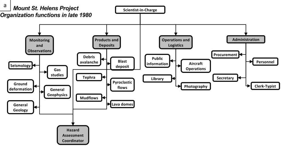
“Within days, the USGS assigned response coordination roles within the USGS for activities such as field investigations, hazards warning, news media contacts, and technical resources (Online Resource 3).”
§ Development of a volcanic risk management system at Mount St. Helens-1980 to present > Initiation of volcanic crisis response
What the sources say
- Not matchedcites Online Resource 3
Couldn’t be matched to a paper in Crossref, so it can’t be checked.
plain- Asserted: passes — The authors put it forward as true.
- Checkable: passes — It can be checked against evidence.
- Load-bearing: unclear — It is unclear whether the paper’s conclusions depend on it.
- Based: passes — The paper gives a reason why it holds.
- Not matched
- It may state two separate claims as one. 87
- Probably not a substantial claim. 77
- The quote only partly states this claim. 1
Create a free account to see these claims.
Create a free account to see these assumptions.
105 more claims
Create a free account to see all 253 claims and to verify the 34 references still open.
Self-check
Percentages, sums and reported differences re-computed from the paper’s own numbers.
Each contradiction between two passages listed here was confirmed by an independent check.
Rated minor: it would not touch a result — a value no result rests on, a p-value that stays on the same side of the significance level, or a conflict that is clerical, resolved elsewhere in the paper, or outside its own findings.
In the paper
§ Development of a volcanic risk management system at Mount St. Helens-1980 to present > Actionable hazard messaging
“Newhall (1982) proposed only quantification of long-term hazard and risk focusing on probabilistic forecasts based on historical and stratigraphic information”
§ Development of a volcanic risk management system at Mount St. Helens-1980 to present > References
“Newhall CG (1982) A method for estimating intermediate and long- term risks from volcanic activity, with an example from Mount St. Helens, Washington.”
Rated minor: it would not touch a result — a value no result rests on, a p-value that stays on the same side of the significance level, or a conflict that is clerical, resolved elsewhere in the paper, or outside its own findings.
In the paper
§ Development of a volcanic risk management system at Mount St. Helens-1980 to present > Volcano hazards and forecasting
“1st MSH hazard assessment published; 1st medium-term forecast at MSH ("eruption by the end of the century").”
§ Development of a volcanic risk management system at Mount St. Helens-1980 to present > Hazards communication and education
“The durations implied by short, medium, and long-term designations span minutes to days, weeks to months, and years to hundreds of years, respectively.”
Citations
Cites
(2013) · Cited by 6,708
Risk Perception and Communication Unplugged: Twenty Years of Process1
Fischhoff, B. (1995) · Risk Analysis · doi:10.1111/j.1539-6924.1995.tb00308.x · Cited by 886
Introduction: `Mode 2' Revisited: The New Production of Knowledge
Nowotny, H., Scott, P., & Gibbons, M. (2003) · Minerva · doi:10.1023/a:1025505528250 · Cited by 871
The 1980 eruptions of Mount St. Helens, Washington
Lipman, P. W., & Mullineaux, D. R. (1981) · USGS professional paper · doi:10.3133/pp1250 · Cited by 686
Siebert, L. (1984) · Journal of Volcanology and Geothermal Research · doi:10.1016/0377-0273(84)90002-7 · Cited by 612
Ascent-driven crystallisation of dacite magmas at Mount St Helens, 1980–1986
Blundy, J., & Cashman, K. V. (2001) · Contributions to Mineralogy and Petrology · doi:10.1007/s004100000219 · Cited by 514
Environmental interpretation. A practical guide for people with big ideas and small budgets
(1993) · Environment International · doi:10.1016/0160-4120(93)90348-l · Cited by 464
National Research Council (1989) · National Academies Press eBooks · doi:10.17226/1189 · Cited by 393
Rutherford, M. J., Sigurdsson, H., Carey, S., & Davis, A. (1985) · Journal of Geophysical Research Atmospheres · doi:10.1029/jb090ib04p02929 · Cited by 390
Volcanic hazards from Bezymianny- and Bandai-type eruptions
Siebert, L., Glicken, H., & Ui, T. (1987) · Bulletin of Volcanology · doi:10.1007/bf01046635 · Cited by 334
A Social Stage Model of Collective Coping: The Loma Prieta Earthquake and The Persian Gulf War
Pennebaker, J. W., & Harber, K. D. (1993) · Journal of Social Issues · doi:10.1111/j.1540-4560.1993.tb01184.x · Cited by 322
Cashman, K. V. (1992) · Contributions to Mineralogy and Petrology · doi:10.1007/bf00306547 · Cited by 303
A volcano rekindled: The renewed eruption of Mount St. Helens, 2004-2006
Sherrod, D. R., Scott, W. E., & Stauffer, P. H. (2008) · USGS professional paper · doi:10.3133/pp1750 · Cited by 297
Constructing event trees for volcanic crises
Newhall, C., & Hoblitt, R. (2002) · Bulletin of Volcanology · doi:10.1007/s004450100173 · Cited by 291
Self-citationGigantic eruption of the volcano bezymianny
Gorshkov, G. S. (1959) · Bulletin Volcanologique · doi:10.1007/bf02596572 · Cited by 261
Zircon reveals protracted magma storage and recycling beneath Mount St. Helens
Claiborne, L. L., Miller, C. F., Flanagan, D. M., Clynne, M. A., & Wooden, J. L. (2010) · Geology · doi:10.1130/g31285.1 · Cited by 222
Self-citationLifetime and size of shallow magma bodies controlled by crustal-scale magmatism
Karakaş, Ö., Degruyter, W., Bachmann, O., & Dufek, J. (2017) · Nature Geoscience · doi:10.1038/ngeo2959 · Cited by 220
Distribution of melt beneath Mount St Helens and Mount Adams inferred from magnetotelluric data
Hill, G. J., Caldwell, T. G., Heise, W., Chertkoff, D. G., Bibby, H. M., Burgess, M. K., Cull, J. P., & Cas, R. A. F. (2009) · Nature Geoscience · doi:10.1038/ngeo661 · Cited by 211
The issue of trust and its influence on risk communication during a volcanic crisis
Haynes, K., Barclay, J., & Pidgeon, N. (2007) · Bulletin of Volcanology · doi:10.1007/s00445-007-0156-z · Cited by 211
Magma supply, magma discharge and readjustment of the feeding system of mount St. Helens during 1980
Scandone, R., & Malone, S. D. (1985) · Journal of Volcanology and Geothermal Research · doi:10.1016/0377-0273(85)90036-8 · Cited by 206
Volcano instability: a review of contemporary themes
McGuire, W. J. (1996) · Geological Society, London, Special Publications · doi:10.1144/gsl.sp.1996.110.01.01 · Cited by 201
Community Resilience to Volcanic Hazard Consequences
Paton, D., Millar, M., & Johnston, D. (2001) · Natural Hazards · doi:10.1023/a:1011882106373 · Cited by 197
Massive collapse of volcano edifices triggered by hydrothermal pressurization
Reid, M. E. (2004) · Geology · doi:10.1130/g20300.1 · Cited by 197
Developments in Geotechnical Engineering: From Harvard to New Delhi 1936-1994
Balasubramaniam, A. S., Hong, S., Bergado, D. T., Phienwej, N., & Nutalaya, P. (2021) · CRC Press eBooks · doi:10.1201/9781003211013 · Cited by 189
Gardner, J. E., Rutherford, M. J., Carey, S., & Sigurdsson, H. (1995) · Bulletin of Volcanology · doi:10.1007/bf00298703 · Cited by 187
Encounters of aircraft with volcanic ash clouds: A compilation of known incidents, 1953-2009
Guffanti, M. C., Casadevall, T. J., & Budding, K. E. (2010) · Data series · doi:10.3133/ds545 · Cited by 184
Belousov, A., Voight, B., & Belousova, M. (2007) · Bulletin of Volcanology · doi:10.1007/s00445-006-0109-y · Cited by 178
Landslide Dams : Processes, Risk, and Mitigation
Schuster, R. L. (1986) · Cited by 160
Hydrogeomorphic Effects of Explosive Volcanic Eruptions on Drainage Basins
Pierson, T. C., & Major, J. J. (2014) · Annual Review of Earth and Planetary Sciences · doi:10.1146/annurev-earth-060313-054913 · Cited by 158
Developments in geotechnical engineering 25
Myslivec, A. (1979) · Coastal Engineering · doi:10.1016/0378-3839(79)90031-0 · Cited by 157
Petrogenesis of Mount St. HElens dacitic magmas
Smith, D. R., & Leeman, W. P. (1987) · Journal of Geophysical Research Atmospheres · doi:10.1029/jb092ib10p10313 · Cited by 151
Predicting Eruptions at Mount St. Helens, June 1980 Through December 1982
Swanson, D. A., Casadevall, T. J., Dzurisin, D., Malone, S. D., Newhall, C. G., & Weaver, C. S. (1983) · Science · doi:10.1126/science.221.4618.1369 · Cited by 133
Self-citationCrustal inheritance and a top-down control on arc magmatism at Mount St Helens
Bedrosian, P. A., Peacock, J. R., Bowles-martinez, E., Schultz, A., & Hill, G. J. (2018) · Nature Geoscience · doi:10.1038/s41561-018-0217-2 · Cited by 124
Kiser, E., Palomeras, I., Levander, A., Zelt, C. A., Harder, S. H., Schmandt, B., Hansen, S. M., Creager, K. C., & Ulberg, C. W. (2016) · Geology · doi:10.1130/g37591.1 · Cited by 121
Anderson, K. R., & Segall, P. (2013) · Journal of Geophysical Research Solid Earth · doi:10.1002/jgrb.50169 · Cited by 118
The magma system of Mount St. Helens: non-linear high-resolution P-wave tomography
Lees, J. M. (1992) · Journal of Volcanology and Geothermal Research · doi:10.1016/0377-0273(92)90077-q · Cited by 116
Gas Emissions and the Eruptions of Mount St. Helens Through 1982
Casadevall, T., Rose, W., Gerlach, T., Greenland, L. P., Ewert, J., Wunderman, R., & Symonds, R. (1983) · Science · doi:10.1126/science.221.4618.1383 · Cited by 113
Self-citationMagma ascent rates in explosive eruptions: Constraints from H2O diffusion in melt inclusions
Humphreys, M. C. S., Menand, T., Blundy, J., & Klimm, K. (2008) · Earth and Planetary Science Letters · doi:10.1016/j.epsl.2008.02.041 · Cited by 112
Vallance, J. W., & Iverson, R. M. (2015) · The Encyclopedia of Volcanoes · doi:10.1016/b978-0-12-385938-9.00037-7 · Cited by 109
Cooper, K. M., & Reid, M. R. (2003) · Earth and Planetary Science Letters · doi:10.1016/s0012-821x(03)00262-0 · Cited by 109
Pallister, J. S., Hoblitt, R. P., Crandell, D. R., & Mullineaux, D. R. (1992) · Bulletin of Volcanology · doi:10.1007/bf00278003 · Cited by 106
Self-citationThe scientific management of volcanic crises
Marzocchi, W., Newhall, C. G., & Woo, G. (2012) · Journal of Volcanology and Geothermal Research · doi:10.1016/j.jvolgeores.2012.08.016 · Cited by 104
Self-citationVoluminous arc dacites as amphibole reaction-boundary liquids
Blatter, D. L., Sisson, T. W., & Hankins, W. B. (2017) · Contributions to Mineralogy and Petrology · doi:10.1007/s00410-017-1340-6 · Cited by 101
Reducing risk from lahar hazards: concepts, case studies, and roles for scientists
Pierson, T. C., Wood, N., & Driedger, C. L. (2014) · Journal of Applied Volcanology · doi:10.1186/s13617-014-0016-4 · Cited by 96
Self-citationNew Tree-Ring Dates for Recent Eruptions of Mount St. Helens
Yamaguchi, D. K. (1983) · Quaternary Research · doi:10.1016/0033-5894(83)90080-7 · Cited by 93
Probabilistic criteria for volcano evacuation decisions
Woo, G. (2007) · Natural Hazards · doi:10.1007/s11069-007-9171-9 · Cited by 93
Synthesis of Volcano Monitoring
Pallister, J. S., & McNutt, S. R. (2015) · Elsevier eBooks · doi:10.1016/b978-0-12-385938-9.00066-3 · Cited by 91
Self-citationVP Structure of Mount St. Helens, Washington, USA, imaged with local earthquake tomography
Waite, G. P., & Moran, S. C. (2009) · Journal of Volcanology and Geothermal Research · doi:10.1016/j.jvolgeores.2009.02.009 · Cited by 88
Attenuation and scattering tomography of the deep plumbing system of Mount St. Helens
Siena, L. D., Thomas, C., Waite, G. P., Moran, S. C., & Klemme, S. (2014) · Journal of Geophysical Research Solid Earth · doi:10.1002/2014jb011372 · Cited by 87
Mount St. Helens Volcano: Recent and Future Behavior
Crandell, D. R., Mullineaux, D. R., & Rubin, M. (1975) · Science · doi:10.1126/science.187.4175.438 · Cited by 86
Long-term elevated post-eruption sedimentation at Mount Pinatubo, Philippines
Gran, K. B., Montgomery, D. R., & Halbur, J. C. (2011) · Geology · doi:10.1130/g31682.1 · Cited by 79
Mastin, L. G., Lisowski, M., Roeloffs, E. A., & Beeler, N. M. (2009) · Geophysical Research Letters · doi:10.1029/2009gl039863 · Cited by 77
Barclay, J., Haynes, K., Mitchell, T., Solana, C., Teeuw, R., Darnell, A., Crosweller, H. S., Cole, P., Pyle, D., Lowe, C., et al. (2008) · Geological Society, London, Special Publications · doi:10.1144/sp305.14 · Cited by 74
Magmatic precursors to the 18 May 1980 eruption of Mount St. Helens, USA
Cashman, K. V., & Hoblitt, R. P. (2004) · Geology · doi:10.1130/g20078.1 · Cited by 70
Forecasts and predictions of eruptive activity at Mount St. Helens, USA: 1975–1984
Swanson, D. A., Casadevall, T. J., Dzurisin, D., Holcomb, R. T., Newhall, C. G., Malone, S. D., & Weaver, C. S. (1985) · Journal of Geodynamics · doi:10.1016/0264-3707(85)90044-4 · Cited by 69
Self-citationCooling magma model for deep volcanic long‐period earthquakes
Aso, N., & Tsai, V. C. (2014) · Journal of Geophysical Research Solid Earth · doi:10.1002/2014jb011180 · Cited by 68
Pallister, J., Papale, P., Eichelberger, J., Newhall, C., Mandeville, C., Nakada, S., Marzocchi, W., Loughlin, S., Jolly, G., Ewert, J., et al. (2019) · Journal of Applied Volcanology · doi:10.1186/s13617-019-0082-8 · Cited by 68
Self-citationMoran, S. C. (1994) · Journal of Geophysical Research: Solid Earth · doi:10.1029/93jb02993 · Cited by 67
Clynne, M. A., Calvert, A. T., Wolfe, E. W., Evarts, R. C., Fleck, R. J., & Lanphere, M. A. (2008) · USGS professional paper · doi:10.3133/pp175028 · Cited by 64
Self-citationWashington households' expected responses to lahar threat from Mt. Rainier
Wei, H.-L., & Lindell, M. K. (2016) · International Journal of Disaster Risk Reduction · doi:10.1016/j.ijdrr.2016.10.014 · Cited by 63
Seismic Precursors to the Mount St. Helens Eruptions in 1981 and 1982
Malone, S. D., Boyko, C., & Weaver, C. S. (1983) · Science · doi:10.1126/science.221.4618.1376 · Cited by 61
Humphreys, M. C. S., Cooper, G. F., Zhang, J., Loewen, M. W., Kent, A. J. R., Macpherson, C. G., & Davidson, J. P. (2019) · Contributions to Mineralogy and Petrology · doi:10.1007/s00410-018-1543-5 · Cited by 60
Developing and Applying a Set of Earth Science Literacy Principles
Wysession, M. E., LaDue, N., Budd, D. A., Campbell, K., Conklin, M. H., Kappel, E. S., B.Lewis, G., Raynolds, R. G., Ridky, R. W., Ross, R. M., et al. (2012) · Journal of Geoscience Education · doi:10.5408/11-248.1 · Cited by 59
Seismic evidence for a cold serpentinized mantle wedge beneath Mount St Helens
Hansen, S. M., Schmandt, B., Levander, A., Kiser, E., Vidale, J. E., Abers, G. A., & Creager, K. C. (2016) · Nature Communications · doi:10.1038/ncomms13242 · Cited by 59
Moran, S. C., Freymueller, J. T., LaHusen, R. G., McGee, K. A., Poland, M. P., Power, J. A., Schmidt, D. A., Schneider, D. J., Stephens, G., Werner, C. A., et al. (2008) · Scientific investigations report · doi:10.3133/sir20085114 · Cited by 58
Inclusions in Mount St. Helens dacite erupted from 1980 through 1983
Heliker, C. C. (1995) · Journal of Volcanology and Geothermal Research · doi:10.1016/0377-0273(94)00074-q · Cited by 58
Barker, S. E., & Malone, S. D. (1991) · Journal of Geophysical Research Atmospheres · doi:10.1029/91jb00430 · Cited by 56
The eruption of Redoubt Volcano, Alaska, December 14, 1989-August 31, 1990
Casadevall, T. J., Chouet, B. A., Davies, J. N., Estes, S. A., Gardner, C. A., Hoblitt, R. P., Lahr, J. C., LaHusen, R. G., Major, J. J., McGimsey, R. G., et al. (1990) · U.S. Geological Survey circular/U.S. Geological Survey Circular · doi:10.3133/cir1061 · Cited by 55
Volcanic hazards and public response
Peterson, D. W. (1988) · Journal of Geophysical Research: Solid Earth · doi:10.1029/jb093ib05p04161 · Cited by 53
Recent Lahars from Mount St. Helens, Washington
Mullineaux, D. R., & Crandell, D. R. (1962) · Geological Society of America Bulletin · doi:10.1130/0016-7606(1962)73[855:rlfmsh]2.0.co;2 · Cited by 53
Mount St. Helens eruptive behavior during the past 1,500 yr
Hoblitt, R. P., Crandell, D. R., & Mullineaux, D. R. (1980) · Geology · doi:10.1130/0091-7613(1980)8 · Cited by 52
Local Source Vp and Vs Tomography in the Mount St. Helens Region With the iMUSH Broadband Array
Ulberg, C. W., Creager, K. C., Moran, S. C., Abers, G. A., Thelen, W. A., Levander, A., Kiser, E., Schmandt, B., Hansen, S. M., & Crosson, R. S. (2020) · Geochemistry Geophysics Geosystems · doi:10.1029/2019gc008888 · Cited by 50
Indian Legends of the Pacific Northwest
Clark, E. E. (1953) · doi:10.1525/9780520350960 · Cited by 49
Pacific Northwest Seismic Network - University of Washington
University of Washington (2016) · NSF Seismological Facility for the Advancement of Geoscience (SAGE) · doi:10.7914/sn/uw · Cited by 48
Overview of the 2004 to 2006, and continuing, eruption of Mount St. Helens, Washington
Scott, W. E., Sherrod, D. R., & Gardner, C. A. (2008) · USGS professional paper · doi:10.3133/pp17501 · Cited by 47
Resilient science: The civic epistemology of disaster risk reduction
Donovan, A. R., & Oppenheimer, C. (2015) · Science and Public Policy · doi:10.1093/scipol/scv039 · Cited by 47
Schilling, S. P., Thompson, R. A., Messerich, J. A., & Iwatsubo, E. Y. (2008) · USGS professional paper · doi:10.3133/pp17508 · Cited by 45
Berlo, K., Turner, S., Blundy, J., & Hawkesworth, C. J. (2004) · Contributions to Mineralogy and Petrology · doi:10.1007/s00410-004-0590-2 · Cited by 44
Using Multiple Data Sets to Populate Probabilistic Volcanic Event Trees
Newhall, C. G., & Pallister, J. S. (2015) · Volcanic Hazards, Risks and Disasters · doi:10.1016/b978-0-12-396453-3.00008-3 · Cited by 43
Self-citationKiser, E., Levander, A., Zelt, C. A., Schmandt, B., & Hansen, S. M. (2018) · Geology · doi:10.1130/g45140.1 · Cited by 43
Lowenstern, J. B., Wallace, K., Barsotti, S., Sandri, L., Stovall, W., Bernard, B., Privitera, E., Komorowski, J.-C., Fournier, N., Balagizi, C., et al. (2022) · Journal of Applied Volcanology · doi:10.1186/s13617-021-00112-9 · Cited by 43
Disasters by Design: A Reassessment of Natural Hazards in the United States
(1999) · doi:10.17226/5782 · Cited by 40
The genesis of arc dacites: the case of Mount St. Helens, WA
Wanke, M., Karakaş, Ö., & Bachmann, O. (2019) · Contributions to Mineralogy and Petrology · doi:10.1007/s00410-018-1542-6 · Cited by 39
Pallister, J. S., Thornber, C. R., Cashman, K. V., Clynne, M. A., Lowers, H., Mandeville, C. W., Brownfield, I. K., & Meeker, G. P. (2008) · Professional Paper · doi:10.3133/pp175030 · Cited by 38
Self-citationMusumeci, C., Gresta, S., & Malone, S. D. (2002) · Journal of Geophysical Research: Solid Earth · doi:10.1029/2001jb000629 · Cited by 37
Scott, K. M. (1988) · Geological Society of America eBooks · doi:10.1130/spe229-p23 · Cited by 36
Donovan, A. R., & Oppenheimer, C. (2012) · Journal of Geophysical Research Atmospheres · doi:10.1029/2011jb009080 · Cited by 34
Warning and Response to the Mount St. Helen's Eruption
Kunreuther, H. C., Saarinen, T. F., Sell, J. L., & May, P. (1986) · Journal of Policy Analysis and Management · doi:10.2307/3323270 · Cited by 34
Deep Earthquakes Beneath Mount St. Helens: Evidence for Magmatic Gas Transport?
Weaver, C. S., Zollweg, J. E., & Malone, S. D. (1983) · Science · doi:10.1126/science.221.4618.1391 · Cited by 33
Volcanic-Hazards Studies in the Cascade Range of the Western United States
Crandell, D. R., Mullineaux, D. R., & Miller, C. D. (1979) · Elsevier eBooks · doi:10.1016/b978-0-12-639120-6.50012-1 · Cited by 33
Geochemical and petrological diversity of mafic magmas from Mount St. Helens
Wanke, M., Clynne, M. A., von Quadt, A., Vennemann, T. W., & Bachmann, O. (2019) · Contributions to Mineralogy and Petrology · doi:10.1007/s00410-018-1544-4 · Cited by 33
Self-citationGeologic map of Mount St. Helens, Washington prior to the 1980 eruption
Hopson, C. A. (2008) · Antarctica A Keystone in a Changing World · doi:10.3133/ofr2002468 · Cited by 31
Volcano Surveillance by ACR Silver Fox
Patterson, M. C. L., Mulligan, A., Douglas, J., Robinson, J., & Pallister, J. S. (2005) · AIAA Infotech@Aerospace Conference · doi:10.2514/6.2005-6954 · Cited by 27
Self-citationDebris flows at Mount St. Helens, Washington, USA
Major, J. J., Pierson, T. C., & Scott, K. M. (2007) · Springer Praxis Books · doi:10.1007/3-540-27129-5_27 · Cited by 26
U.S. Geological Survey's alert notification system for volcanic activity
Gardner, C. A., & Guffanti, M. C. (2006) · Fact Sheet · doi:10.3133/fs20063139 · Cited by 26
Crosbie, J., Abers, G. A., Mann, M. E., Janiszewski, H. A., Creager, K. C., Ulberg, C. W., & Moran, S. C. (2019) · Journal of Geophysical Research Solid Earth · doi:10.1029/2019jb017836 · Cited by 26
Major, J. J. (2023) · Geological Society, London, Special Publications · doi:10.1144/sp520-2021-142 · Cited by 24
Hyman, D. M. R., Dietterich, H. R., & Patrick, M. R. (2022) · Journal of Geophysical Research: Solid Earth · doi:10.1029/2022jb024998 · Cited by 24
Pre-1980 tephra-fall deposits erupted from Mount St. Helens, Washington
Mullineaux, D. R. (1996) · Professional Paper · doi:10.3133/pp1563 · Cited by 23
Newhall, C. G. (1982) · Open-File Report · doi:10.3133/ofr82396 · Cited by 22
Self-citationThe Management of Volcano Emergencies: Nevado del Ruiz
Voight, B. (1996) · Monitoring and Mitigation of Volcano Hazards · doi:10.1007/978-3-642-80087-0_22 · Cited by 22
Han, J., Vidale, J. E., Houston, H., Schmidt, D. A., & Creager, K. C. (2018) · Geophysical Research Letters · doi:10.1002/2018gl077063 · Cited by 21
Leeman, W. P., & Smith, D. R. (2018) · American Mineralogist · doi:10.2138/am-2018-6555 · Cited by 21
Major, J. J., Mosbrucker, A. R., & Spicer, K. R. (2018) · Ecological Responses at Mount St. Helens: Revisited 35 years after the 1980 Eruption · doi:10.1007/978-1-4939-7451-1_2 · Cited by 20
Wong, Y. Q., Segall, P., Bradley, A., & Anderson, K. R. (2017) · Journal of Geophysical Research Solid Earth · doi:10.1002/2017jb014343 · Cited by 19
Assessment of increased thermal activity at Mount Baker, Washington, March 1975-March 1976
Frank, D., Meier, M. F., Swanson, D. A., with contributions by Babcock, J. W., Fretwell, M. O., Malone, S. D., Rosenfeld, C. L., Shreve, R. L., & Wilcox, R. E. (1977) · Professional Paper · doi:10.3133/pp1022a · Cited by 18
Get your science used—Six guidelines to improve your products
Perry, S. C., Blanpied, M. L., Burkett, E. R., Campbell, N. M., Carlson, A. E., Cox, D. A., Driedger, C. L., Eisenman, D. P., Fox-Glassman, K. T., Hoffman, S., et al. (2016) · U.S. Geological Survey circular/U.S. Geological Survey Circular · doi:10.3133/cir1419 · Cited by 18
Self-citationPallister, J. S., Clynne, M. A., Wright, H. M. N., Eaton, A. R. V., Vallance, J. W., Sherrod, D. R., & Kokelaar, B. P. (2017) · Scientific investigations report · doi:10.3133/sir20175022d · Cited by 18
Self-citationVolcanic eruptions of 1980 at Mount St. Helens: The first 100 days
Foxworthy, B. L., & Hill, M. (1982) · Professional Paper · doi:10.3133/pp1249 · Cited by 17
Effects of lava-dome growth on the crater glacier of Mount St. Helens, Washington
Walder, J. S., Schilling, S. P., Vallance, J. W., & LaHusen, R. G. (2008) · USGS professional paper · doi:10.3133/pp175013 · Cited by 17
Volcano hazards program in the United States
Tilling, R. I., & Bailey, R. A. (1985) · Journal of Geodynamics · doi:10.1016/0264-3707(85)90045-6 · Cited by 17
Contemporary Responses to Volcanism: Case Studies from the Cascades and Hawaii
HODGE, D., SHARP, V., & MARTS, M. (1979) · Volcanic Activity and Human Ecology · doi:10.1016/b978-0-12-639120-6.50013-3 · Cited by 17
Effects of Mount St. Helens eruption on selected lakes in Washington
Dion, N. P., & Embrey, S. S. (1981) · U.S. Geological Survey circular/U.S. Geological Survey Circular · doi:10.3133/cir850g · Cited by 16
Mount St. Helens Retrospective: Lessons Learned Since 1980 and Remaining Challenges
Dzurisin, D. (2018) · Frontiers in Earth Science · doi:10.3389/feart.2018.00142 · Cited by 15
Nakada, S., Miyagi, Y., Kubo, T., & Fujita, E. (2019) · Journal of Disaster Research · doi:10.20965/jdr.2019.p0623 · Cited by 15
Stovall, W. K., Ball, J. L., Westby, E. G., Poland, M. P., Wilkins, A. M., & Mulliken, K. M. (2023) · Frontiers in Communication · doi:10.3389/fcomm.2023.976041 · Cited by 15
GPS ground deformation patterns at Mount St. Helens (Washington, USA) from 2004 to 2010
Palano, M., Guarrera, E., & Mattia, M. (2012) · Terra Nova · doi:10.1111/j.1365-3121.2011.01049.x · Cited by 13
Babb, J. L., Kauahikaua, J. P., & Tilling, R. I. (2011) · General Information Product · doi:10.3133/gip135 · Cited by 12
Wong, Y. Q., & Segall, P. (2020) · Geochemistry Geophysics Geosystems · doi:10.1029/2020gc009343 · Cited by 12
Community preparedness for volcanic hazards at Mount Rainier, USA
Vinnell, L. J., Doyle, E. E. H., Johnston, D. M., Becker, J., Kaiser, L., Lindell, M. K., Bostrom, A., Gregg, C. E., Dixon, M., & Terbush, B. (2021) · Journal of Applied Volcanology · doi:10.1186/s13617-021-00110-x · Cited by 12
George, D. L., Iverson, R. M., & Cannon, C. M. (2022) · Open-File Report · doi:10.3133/ofr20211118 · Cited by 12
Frenzen, P. M., & Matarrese, M. T. (2008) · USGS professional paper · doi:10.3133/pp175023 · Cited by 11
The Volcano Hazards Program; objectives and long-range plans
Bailey, R. A., Beauchemin, P. R., Kapinos, F. P., & Klick, D. W. (1983) · Open-File Report · doi:10.3133/ofr83400 · Cited by 11
Living with a volcano in your backyard: An educator's guide with emphasis on Mount Rainier
Driedger, C. L., Doherty, A., Dixon, C., & Faust, L. M. (2005) · General information product. U.S. Geological Survey · doi:10.3133/gip19 · Cited by 11
Self-citationEngineering the Incident Command and Multiagency Coordination Systems
Stambler, K. S., & Barbera, J. A. (2011) · Journal of Homeland Security and Emergency Management · doi:10.2202/1547-7355.1838 · Cited by 11
Sclafani, P., Nygaard, C., & Thorne, C. (2018) · Earth Surface Processes and Landforms · doi:10.1002/esp.4277 · Cited by 11
Mount St. Helens, Master Teacher
Newhall, C. G. (2000) · Science · doi:10.1126/science.288.5469.1181 · Cited by 10
Self-citationMurray, T. L., Ewert, J. W., Lockhart, A. B., & LaHusen, R. G. (1996) · Monitoring and Mitigation of Volcano Hazards · doi:10.1007/978-3-642-80087-0_10 · Cited by 10
Self-citationWong, Y. Q., & Segall, P. (2019) · Journal of Geophysical Research Solid Earth · doi:10.1029/2019jb017585 · Cited by 10
A checklist for crisis operations within volcano observatories
Newhall, C. G., Pallister, J. S., & Miller, C. D. (2021) · Forecasting and Planning for Volcanic Hazards, Risks, and Disasters · doi:10.1016/b978-0-12-818082-2.00013-5 · Cited by 10
Self-citationMount St. Helens: A 30‐Year Legacy of Volcanism
Vallance, J. W., Gardner, C. A., Scott, W. E., Iverson, R. M., & Pierson, T. C. (2010) · Eos, Transactions American Geophysical Union · doi:10.1029/2010eo190001 · Cited by 9
Deterministic Versus Probabilistic Volcano Monitoring: Not “or” But “and”
Rouwet, D., Constantinescu, R., & Sandri, L. (2017) · Advances in Volcanology · doi:10.1007/11157_2017_8 · Cited by 9
Kiser, E., Levander, A., Zelt, C. A., Schmandt, B., & Hansen, S. M. (2019) · Journal of Geophysical Research Solid Earth · doi:10.1029/2018jb016203 · Cited by 9
Satellite Observations Of The Mount St. Helens Eruption Of 18 May 1980:
Rice, C. J. (1981) · SPIE Proceedings · doi:10.1117/12.931922 · Cited by 8
The Volcano Disaster Assistance Program—Helping to save lives worldwide for more than 30 years
Lowenstern, J. B., & Ramsey, D. W. (2017) · Fact Sheet · doi:10.3133/fs20173071 · Cited by 8
Ten ways Mount St. Helens changed our world—The enduring legacy of the 1980 eruption
Driedger, C. L., Major, J. J., Pallister, J. S., Clynne, M. A., Moran, S. C., Westby, E. G., & Ewert, J. W. (2020) · Fact sheet · doi:10.3133/fs20203031 · Cited by 7
Self-citationMajor, J. J. (2020) · Science · doi:10.1126/science.abb4120 · Cited by 7
Recovering Analog-Tape Seismograms from the 1980 Mount St. Helens Pre-Eruption Period
Malone, S. D. (2020) · Seismological Research Letters · doi:10.1785/0220190327 · Cited by 6
Driedger, C., Calvache, M., Cortés, G. P., Ewert, J., Montoya, J., Lockhart, A., Allen, R., Banks, D., Beason, S., Bocanegra, H. T., et al. (2020) · Journal of Applied Volcanology · doi:10.1186/s13617-019-0090-8 · Cited by 6
Self-citationSemiquantitative assessment of changing volcanic risk at Mount St. Helens, Washington
Newhall, C. G. (1984) · Open-File Report · doi:10.3133/ofr84272 · Cited by 5
Self-citationLearning from Mount St. Helens: Catastrophic Events as Educational Opportunities
Anderson, J. (1987) · Journal of Geography · doi:10.1080/00221348708979491 · Cited by 5
Grant, G. E., Major, J. J., & Lewis, S. L. (2017) · doi:10.2737/pnw-gtr-954 · Cited by 5
USGS Cascades Volcano Observatory news media management guide — General protocols and templates
Driedger, C. L., & Westby, E. G. (2020) · U.S. Geological Survey circular/U.S. Geological Survey Circular · doi:10.3133/cir1462 · Cited by 5
Self-citationA 40-year story of river sediment at Mount St. Helens
Uhrich, M. A., Spicer, K. R., Mosbrucker, A. R., Saunders, D. R., & Christianson, T. S. (2021) · Fact Sheet · doi:10.3133/fs20213004 · Cited by 5
Mastin, L. G., Carey, S. N., Eaton, A. R. V., Eychenne, J., & Sparks, R. S. J. (2022) · Bulletin of Volcanology · doi:10.1007/s00445-022-01613-0 · Cited by 5
Volcano Tourism: The Effect of Eruptions and Disasters
Gaudru, H. (2014) · Geoheritage, Geoparks and Geotourism · doi:10.1007/978-3-642-16191-9_26 · Cited by 4
Communicating hazards—A social science review to meet U.S. Geological Survey needs
Milch, K. F., Perry, S. C., & Bruce, J. L. (2019) · U.S. Geological Survey circular/U.S. Geological Survey Circular · doi:10.3133/cir1449 · Cited by 4
Major, J. J., Grant, G. E., Sweeney, K., & Mosbrucker, A. R. (2020) · Scientific Investigations Report · doi:10.3133/sir20205027 · Cited by 4
An installation guide to the PC-based time-series data-management and plotting program BOB
Murray, T. L. (1990) · Antarctica A Keystone in a Changing World · doi:10.3133/ofr90634b · Cited by 4
An observatory for the study of Lassen Peak1
Finch, R. H. (1928) · Bulletin of the Seismological Society of America · doi:10.1785/bssa0180010005 · Cited by 3
Kelly, P. J., Ketner, D. M., Kern, C., LaHusen, R. G., Lockett, C., Parker, T., Paskievitch, J. F., Pauk, B. A., Rinehart, A. J., & Werner, C. A. (2015) · AGU Fall Meeting Abstracts · Cited by 3
The Volcano Hazards Program — Strategic science plan for 2022–2026
Mandeville, C. W., Cervelli, P. F., Avery, V. F., & Wilkins, A. M. (2022) · Circular · doi:10.3133/cir1492 · Cited by 3
A Decision Framework for Managing the Spirit Lake and Toutle River System at Mount St. Helens
Board on Earth Sciences and Resources, Water Science and Technology Board, Studies, D. O. E. A. L., Board on Environmental Change and Society, Education, D. O. B. A. S. S. A., & National Academies of Sciences, E. (2017) · National Academies Press eBooks · doi:10.17226/24874 · Cited by 3
Eruption: The Untold Story of Mount St. Helens.
Fischman, J. (2016) · Scientific American · Cited by 2
Finding High Ground: Simulating an Evacuation in a Lahar Risk Zone
Bard, J. A. (2016) · Scholars' Bank (University of Oregon) · Cited by 1
The eruptions of Lassen Peak, California
Diller, J. S. (1914) · Bulletin of the Seismological Society of America · doi:10.1785/bssa0040030103 · Cited by 1
Survey, U. S. G. (1997) · doi:10.3133/70043848 · Cited by 1
Rowley, P. D., Hait, M. H., Russell-Robinson, S. L., Buchanan-Banks, J. M., & Cashman, K. V. (1986) · Open-File Report · doi:10.3133/ofr86509
Lumsden (1985) · doi:10.1130/0091-7613(1985)13
Scott (1992) · doi:10.1130/0091-7613(1992)020
(2013)
(2019) · AGU Fall Meeting Abstracts
Research works printed but not linked: 50
- Allen J (1980) Final report on the operations of the Mount St. Helens Research and Educational Coordinating Committee
- Burket SD, Furlow EP, Golding PR, Grant LC, Lipovsky WA, Lopp TG (1980) The economic effects of the eruptions of Mt. St. Helens: report to the Committee on Ways and Means of the U.S. House of Representatives on investigation no. 332-110 under section 332 of the Tariff act of 1930. U.S. International Trade Commission, Washington, DC
- Christiansen RL, Peterson DW, Lipman PW, Mullineaux DR (1981) Chronology of the 1980 eruptive activity. In: Lipman PW, Mullineaux DR (eds) The 1980 eruptions of Mount St. Helens, Washington. US Geol Surv Prof Pap 1250:17–30
- Crandell DR (1987) Deposits of Pre-1980 pyroclastic flows and lahars from Mount St. Helens Volcano. US Geol Surv Prof Pap 1444, Washington
- Crandell DR (1989) Gigantic debris avalanche of Pleistocene age from ancestral Mount Shasta volcano, California, and debris-avalanche hazard zonation. US Geol Surv Bulletin 1861:32
- Crandell DR, Mullineaux DR (1978) Potential hazards from future eruptions of Mt. St. Helens volcano. US Geol Surv Bull 1383-C, Washington, p 26
- Decker RW (1981) The 1980 activity-a case study in forecasting volcanic eruptions In: Lipman PW, Mullineaux DR (eds) The 1980 eruptions of Mount St. Helens, Washington. US Geol Surv Prof Pap 1250:815–820
- Drabek TE, Tamminga HL, Kilijanek TS, Adams CR (1981) Managing multiorganizational emergency responses-emergents search and rescue networks in natural disaster and remote area settings: monograph #31. Institute of Behavioral Science, The University of Colorado, p 292
- Endo ET, Malone SD, Noson LL, Weaver CS (1981) Locations, magnitudes, and statistics of the March 20–May 18 earthquake sequence. In: Lipman PW, Mullineaux DR (eds) The 1980 eruptions of Mount St. Helens, Washington. US Geol Surv Prof Pap 1250:93–107
- Ewert J, Guffanti M, Murray T (2005) An assessment of volcanic threat and monitoring capabilities in the United States—framework for a National Volcanic Early Warning System, NVEWS. US Geol Surv Open-File Rep 1164:1–62
- Ewert JW, Murray TL, Lockhart AB, Miller CD (1993) Preventing volcanic catastrophe; the US International Volcano Disaster Assistance Program. Earthquakes Volcanoes (USGS) 24(6):270–291
- FEMA (2006) Civil Defense and Homeland Security: a short history of national preparedness efforts. Homeland Security National Preparedness Task Force, p 36
- Fiske RS (1984) Volcanologists, journalists, and the concerned local public: a tale of two crises in the Eastern Caribbean. Interception, Evolution, and Hazard. National Academy Press, Washington, DC, Explosive Volcanism, pp 170–176
- Flinders AF, Shen Y (2017) Seismic evidence for a possible deep crustal hot zone beneath Southwest Washington. Nature Comm Sci Rep 7:7400
- Gerlach TM, McGee KA, Doukas MP (2008) Emission Rates of CO2, SO2, and H2S, scrubbing, and preeruption excess volatiles at Mount St. Helens, 2004–2005. In: Sherrod DR, Scott WE, Stauffer PH (eds) A volcano rekindled; the renewed eruption of Mount St. Helens, 2004-2006. US Geol Surv Prof Pap 1750: 543–571.
- Hopson CA, Melson WG (1990) Compositional trends and eruptive cycles at Mount St. Helens. Geosci Canada 17:131–141
- Kilijanek TS (1981) There she blows: the search and rescue response to the Mount St. Helens Volcano. SAR Research Project Report 11. Department of Sociology, University of Denver, Denver, Colorado
- Lisowski M, Dzurisin D, Denlinger RP, Iwatsubo EY (2008) Analysis of GPS-measured deformation associated with the 2004–2006 dome-building eruption of Mount St. Helens, Washington. In: Sherrod DR, Scott WE, Stauffer PH (eds) A volcano rekindled: the renewed eruption of Mount St. Helens, 2004–2006, vol 1850. US Geol Surv Prof Pap, pp 301–333
- Ludwin RS, Qamar AI, Malone SD, Jonientz-Trisler C, Crosson RS, Benson R, Moran SC (1994) Earthquake Hypocenters in Washington and Northern Oregon, 1987-1989, and operation of the Washington Regional Seismograph Network, vol 89. Washington Division of Geology and Earth Resources, Information Circular, p 40
- Majors H, McCollum RC (eds) (1981) Mount St. Helens–the 1831 and 1835 eruptions, and Mount St. Helens–The 1844-1857 Eruptions: Northwest Discov 2(8):534–550
- Malone SD, Endo ET, Weaver CS, Ramey JW (1981) Seismic monitoring for eruption prediction In: Lipman PW, Mullineaux DR (eds) The 1980 eruptions of Mount St. Helens, Washington. US Geol Surv Prof Pap 1250:803–814. https://doi.org/10.3133/pp1250 · DOI
- McChesney PJ, Couchman MR, Moran SC, Lockhart AB, Swinford KJ, LaHusen RG (2008) Seismic-monitoring changes and the remote deployment of seismic stations (seismic spider) at Mount St. Helens, 2004–2005. In: Sherrod DR, Scott WE, Stauffer PH (eds) A volcano rekindled: the renewed eruption of Mount St. Helens, 2004–2006. US Geol Surv Prof Pap 1750:129–140
- McClure RH, Reynolds ND (2015) Making the list: Mount St. Helens as a traditional cultural property: a case study in tribal/government cooperation. J Northwest Anthropol 49:117–142
- Meyer W, Sabol M, Schuster R (1986) Landslide dammed lakes at Mount St. Helens, Washington. In: Schuster, R.L. (ed.) Landslide Dams – Processes, Risks and Mitigation. American Society of Civil Engineers Geotechnical Special Publication 3:21–41
- Miller CD, Mullineaux DR, Crandell DR (1981) Hazards assessments at Mount St. Helens. In: Lipman PW, Mullineaux DR (eds) The 1980 eruptions of Mount St. Helens, Washington, vol 1250. US Geol Surv Prof Pap, pp 803–814. https://doi.org/10.3133/pp1250 · DOI
- Moore JG, Sisson TW (1981) Deposits and effects of the May 18 pyroclastic surge. In: Lipman PW, Mullineaux DR (eds) The 1980 eruptions of Mount St. Helens, Washington. US Geol Surv Prof Pap 1250:421–438. https://doi.org/10.3133/pp1250 · DOI
- Moran SC, Malone SD, Qamar AI, Thelen WA, Wright AK, Caplan-Auerbach J (2008b) Seismicity associated with renewed dome building at Mount St. Helens, 2004–2005. In: Sherrod DR, Scott WE, Stauffer PH (eds) A volcano rekindled: the renewed eruption of Mount St. Helens, 2004–2006. US Geol Surv Prof Pap 1750: 27–60
- Moran SC, McChesney PJ, Lockhart AB (2008c) Seismicity and infrasound associated with explosions at Mount St. Helens, 2004–2005. In: Sherrod DR, Scott WE, Stauffer PH (eds) A volcano rekindled: the renewed eruption of Mount St. Helens, 2004–2006. US Geol Surv Prof Pap 1750: 111–127
- Mullineaux DR, Hyde JH, Rubin M (1975) Widespread late glacial and postglacial tephra deposits from Mount St. Helens volcano, Washington. Jour Res US Geol Surv 3:329–335
- Ocel C, Carroll TM (1995) Where the river begins-an educator’s guide to the Nisqually River of Mount Rainier National Park. Nisqually River Education Project. National Park Service, Yelm, Washington, p 163
- Paine AM, Meyer DF, Schumm SA (1987) Incised channel and terrace formation near Mount St. Helens, Washington. In: Beschta RL, Blinn T, Grant GE, Ice GG, Swanson FJ (eds) Erosion and sedimentation in the Pacific Rim, vol 165. International Association of Hydrological Sciences Publication, pp 389–390
- Perry RW, Lindell MK (1990) Living with Mount St. Helens—human adjustment to volcano hazards. Washington State University Press, Pullman, p 205
- Peterson DW (1982) Operations of the U.S. Geological Survey at Mount St. Helens. In: Martin RC, Davis JF (eds) Status of Volcanic Prediction and Emergency Response Capabilities in Volcanic Hazard Zones of California In: Martin RC, Davis JF (eds) Cal Dept of Conservation and Division of Mines and Geology, Special Pub, vol 63, pp 193–204
- Pinsker LM (2004) Paths of destruction: the hidden threat of Mount Rainier. Geotimes 49:18–23. http://www.geotimes.org/apr04/feature_MountRainier.html. Accessed 16 May 2023
- Pope C (1980) Mount St. Helens classroom activities: elementary. Educational Service District 112:254
- Pringle PT, Cameron KA, Pierson TC (1999) Eruption-triggered lahar on May 14, 1984. US Geol Surv Prof Pap 1586:81–103
- Rowley PD (1981) Pyroclastic-flow deposits. In: Lipman PW, Mullineaux DR (eds) The 1980 eruptions of Mount St. Helens. US Geol Surv Prof Pap 1250: 489–512. https://doi.org/10.3133/pp1250 · DOI
- Rutherford MJ, Devine JD (2008) Magmatic conditions and processes in the storage zone of the 2004–2006 Mount St. Helens dacite. In: Sherrod DR, Scott WE, Stauffer PH (eds) A volcano rekindled; the renewed eruption of Mount St. Helens, 2004–2006. US Geol Surv Prof Pap 1750: 703–725
- Sherrod DR, Scott WE, Stauffer PH (2008) A volcano rekindled: the renewed eruption of Mount St. Helens, 2004-2006. US Geol Surv Prof Paper 1750
- Sorensen JH (1982) Emergency planning for rare events: some behavioral science lessons for volcano hazards management. In: Martin RC, Davis JF (eds) Status of volcanic hazard prediction and emergency response capabilities in volcanic hazard zones of California, Special publication 63, Proceedings of a workshop on volcanic hazards in California, December 3-4 1981. California Department of Conservation of Mines and Geology, pp 153–167
- Terbush and Driedger (2019) Rapid response reference page for 911 responders In: Pierce County Department of Emergency Management. Mount Rainier Response Plan, Tacoma, WA, pp 127–128
- U.S. Army Corps of Engineers (1986) Mount St Helens, Washington - Toutle, Cowlitz and Columbia Rivers, vol 3. Portland District, Sedimentation Design Memorandum
- Ulberg CW, Abers GA, Bachmann O, Bedrosian P, Blatter DL, Bowles-Martinez E, Clynne MA, Creager KC, Crosbie K, Denlinger RP, Glascow ME, Han J, Hansen SM, Hill GJ, Kiser E, Levander A, Mann M, Meng X, Moran S et al (2017) Imaging magma under Mount St. In: Helens with geophysical and petrologic methods, vol 39. GeoPRISMS Newsletter
- Voight B, Glicken H, Janda RJ, Douglass PM (1981) Catastrophic rockslide avalanche on May 18. In: Lipman and Mullineaux (eds) The 1980 eruptions of Mount St. Helens Washington. US Geol Surv Prof Pap 1250:347–377
- Waitt RB, Malone SC (in press) Pre-cataclysmic phreatic eruptions at Mount St. Helens, 1980. US Geol Surv Prof Pap 1251A
- Weaver CS, Grant WC, Shemata JE (1987) Local crustal extension at Mount St.Helens. Washington: J Geophys Res 92:10,170–10,178
- Westby EG (2016) GeoGirls: Five days of discovery at Mount St. Helens (video). US Geological Survey and Mount St. Helens Institute 6:34 minutes. Accessed 27 September 2021
- Willingham WF (2005) The Army Corps of Engineers’ short-term response to the eruption of Mount St. Helens. Or Hist Q 106:174–203
- Wolfe EW, Pierson TC (1995) Volcanic-hazard zonation for Mount St. Helens, Washington, 1995. US Geol Surv Open-File Rep 95–497:1–14
- Zarcadoolas C, Vaughon W (2018) Broadening the accessibility of Hawaiian volcano observatory daily updates, report to USGS Contract # G15PC00059. How To Health Literacy, LLC New York, NY, p 44
Cited by
Following the tug of the audience from complex to simplified hazards maps at Cascade Range volcanoes
Driedger, C. L., Ramsey, D. W., Scott, W. E., Faust, L. M., Bard, J. A., & Wold, P. (2024) · Journal of Applied Volcanology · doi:10.1186/s13617-024-00142-z · Cited by 3
Self-citationVOLCANBOX: A software platform for volcanic hazard assessment
Martínez-Sepúlveda, M., Martí, J., & López‐Saavedra, M. (2024) · International Journal of Disaster Risk Reduction · doi:10.1016/j.ijdrr.2024.104817 · Cited by 2
Теоретическое обоснование необходимости зонирования и мониторинга земель вулканоопасных территорий
Верхотуров, А. А. (2025) · Vestnik SSUGT (Siberian State University of Geosystems and Technologies) · doi:10.33764/2411-1759-2025-30-2-156-165 · Cited by 2
Methodological principles of zoning and land monitoring in areas of active volcanism
Верхотуров, А. А. (2025) · Geodesy and Cartography · doi:10.22389/0016-7126-2025-1025-11-42-51 · Cited by 1
Harris, A. J. L., Mutaqin, B. W., & Kelfoun, K. (2024) · Bulletin of Volcanology · doi:10.1007/s00445-024-01762-4
Metadata
- Authors
- Wright, H. M. N., Driedger, C. L., Pallister, J. S., Newhall, C. G., Clynne, M. A., & Ewert, J. W.
- Affiliations
- United States Geological Survey (US)
- Corresponding author
- Wright, Heather M. N.
- Venue
- Bulletin of Volcanology
- Published
- 2023-09-08
- Volume
- 85
- Issue
- 10
- ISSN
- 0258-8900 (ISSN-L)
- 1432-0819
- OpenAlex
- W4386544133
- Semantic Scholar
- 48742ddaf3f42684401f7e9ebaf6207beeb1b0d6
- Cited by
- 10
- References
- 163
- Citations by year
- 2026: 3 · 2025: 4 · 2024: 3
- FWCI
- 2.94
- Type
- journal article
- Language
- en
- Open access
- hybrid
- doi.org
- Locations
- Bulletin of Volcanology (publishedVersion, cc-by)
- Funders
- U.S. Geological Survey
- Topics
- Social Sciences › Sociology and Political Science › Disaster Management and Resilience
- Social Sciences › Communication › Public Relations and Crisis Communication
- Social Sciences › Safety Research › Safety and Risk Management
- Keywords
- Mount St. Helens, volcanic risk management, volcanic hazard assessment, eruption forecasting, volcano monitoring, emergency planning, hazard communication, inter-agency coordination, Cascade Range volcanoes, risk mitigation
About these checks
Registry, retraction, Cites and statistics results are computed, not judged, with one exception: a printed reference that no index lists is read once by a model before it counts as a citation error. Claims are extracted by a model and kept only when their quote appears verbatim in the text; each cited source is then checked, with a model’s help, for whether it says what the claim relies on. Those verdicts can be wrong — read the claim’s quote and the cited source before relying on one.
A language model drew the claims from the paper on 2026-11-12, under version 3 of the claim definition (model deepseek-v4.1-flash, prompt extract-v3).
A second model labelled each claim on 2026-11-12 (model jev-1.13-20260917, definition revision gold-guideline-v0.2).
Statistics and arithmetic are recomputed, not judged.
Confidence bands are shown only for fields calibrated on our annotated test set. None is calibrated yet, so no band is shown.
What counts as a claim ›How we measure confidence ›How we check this ›
Are you an author, or do you see a problem with this page? Request a review
