

The DOI matches its Crossref record; 31 of the 31 references it cites were found in a registry or an index.
A Project for Monitoring Trends in Burn Severity
Open accessAbstract
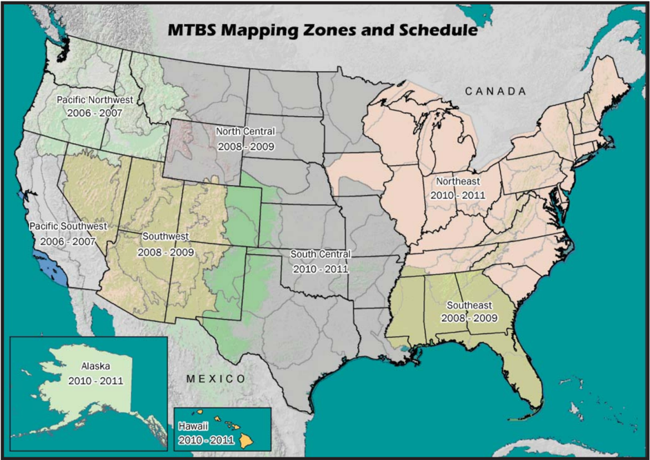
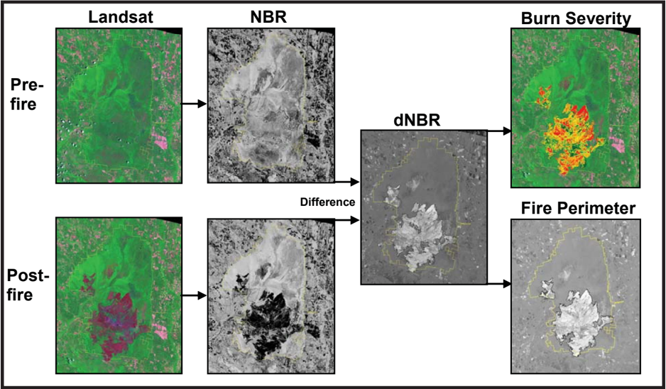
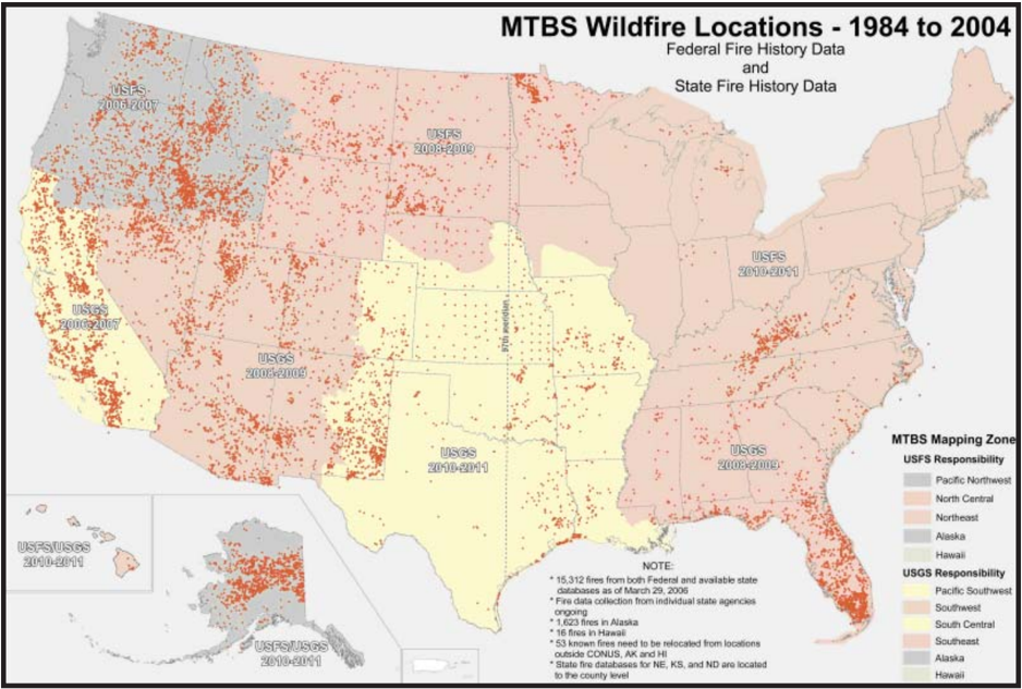
Elected officials and leaders of environmental agencies need information about the effects of large wildfires in order to set policy and make management decisions. Recently, the Wildland Fire Leadership Council (WFLC), which implements and coordinates the National Fire Plan (NFP) and Federal Wildland Fire Management Policies (National Fire Plan 2004 ), adopted a strategy to monitor the effectiveness of the National Fire Plan and the Healthy Forests Restoration Act (HFRA). One component of this strategy is to assess the environmental impacts of large wildland fires and identify the trends of burn severity on all lands across the United States. To that end, WFLC has sponsored a six-year project, Monitoring Trends in Burn Severity (MTBS), which requires the U.S. Department of Agriculture Forest Service (USDA-FS) and the U.S. Geological Survey (USGS) to map and assess the burn severity for all large current and historical fires. Using Landsat data and the differenced Normalized Burn Ratio (dNBR) algorithm, the USGS Center for Earth Resources Observation and Science (EROS) and USDA-FS Remote Sensing Applications Center will map burn severity of all fires since 1984 greater than 202 ha (500 ac) in the east, and 404 ha (1,000 ac) in the west. The number of historical fires from this period combined with current fires occurring during the course of the project will exceed 9,000. The MTBS project will generate burn severity data, maps, and reports, which will be available for use at local, state, and national levels to evaluate trends in burn severity and help develop and assess the effectiveness of land management decisions. Additionally, the information developed will provide a baseline from which to monitor the recovery and health of fire-affected landscapes over time. Spatial and tabular data quantifying burn severity will augment existing information used to estimate risk associated with a range of current and future resource threats. The annual report of 2004 fires has been completed. All data and results will be distributed to the public on a Web site.
Overview
The claims and statistics of this paper haven’t been checked yet.
Run the check — free, no account needed. It reads the open-access text and checks the sources it cites.
Integrity signals
Registry
Cites
Statistics
Figures
Verification
Claims the paper makes
The claims and statistics of this paper haven’t been checked yet.
Run the check — free, no account needed. It reads the open-access text and checks the sources it cites.
Claims other papers make about this one
Each is checked against this paper’s own text: does it say what the citing paper says it does?
In the citing paper
“MTBS is currently the best dataset available for the purpose of this analysis, because it contains the largest historical record of CONUS wildland fires larger than 405 ha (1000 acres) in the West, and larger than 202 ha (500 acres) in the East, respectively, between 1984 and 2016.”
From Burned forests impact water supplies (2018) · cites this paper as [27]
Self-check
Percentages, sums and reported differences re-computed from the paper’s own numbers.
The self-check needs the paper’s full text.
Citations
Cites
Photogrammetric Engineering and Remote Sensing
Nicol, J., King, B., Quattrochi, D., Dowman, I. J., Ehlers, M., & Xiaoli, D. (2007) · UCL Discovery (University College London) · Cited by 9,325
Development of a 2001 National Land-Cover Database for the United States
Homer, C. G., Huang, C., Yang, L., Wylie, B. K., & Coan, M. J. (2004) · Photogrammetric Engineering & Remote Sensing · doi:10.14358/pers.70.7.829 · Cited by 1,567
Miller, J. D., & Thode, A. E. (2007) · Remote Sensing of Environment · doi:10.1016/j.rse.2006.12.006 · Cited by 1,444
Remote sensing techniques to assess active fire characteristics and post-fire effects
Lentile, L. B., Holden, Z. A., Smith, A. M. S., Falkowski, M. J., Hudak, A. T., Morgan, P., Lewis, S. A., Gessler, P. E., & Benson, N. (2006) · International Journal of Wildland Fire · doi:10.1071/wf05097 · Cited by 1,002
International Journal of Remote Sensing
(2011) · International Journal of Remote Sensing · doi:10.1080/01431161.2012.638042 · Cited by 1,000
Mapping burns and natural reforestation using thematic Mapper data
García, M. J. L., & Caselles, V. (1991) · Geocarto International · doi:10.1080/10106049109354290 · Cited by 743
FEDERAL FOREST‐FIRE POLICY IN THE UNITED STATES
Stephens, S. L., & Ruth, L. W. (2005) · Ecological Applications · doi:10.1890/04-0545 · Cited by 584
Comparison of burn severity assessments using Differenced Normalized Burn Ratio and ground data
Cocke, A. E., Fulé, P. Z., & Crouse, J. E. (2005) · International Journal of Wildland Fire · doi:10.1071/wf04010 · Cited by 498
Comparison of AVIRIS and Landsat ETM+ detection capabilities for burn severity
van Wagtendonk, J. W., Root, R. R., & Key, C. H. (2004) · Remote Sensing of Environment · doi:10.1016/j.rse.2003.12.015 · Cited by 467
A change detection experiment using vegetation indices.
Lyon, J. G., Yuan, D., Lunetta, R. S., & Elvidge, C. D. (1998) · Cited by 462
Research works printed but not linked: 3
- Gmelin, M., and K. Brewer. 2002. Operational change detection-based fire severity mapping using Landsat TM data. P. 1–8 in Rapid delivery of remote sensing products [electronic resource]: proceedings of the Ninth Forest Service Remote Sensing Applications Conference, Greer, J. (ed.). ASPRS, San Diego, California.
- Key, C.H., and N.C. Benson. 2002. Measuring and remote sensing of burn severity, U.S. Geological Survey wildland fire workshop.
- Thode, A. 2005. Quantifying the fire regime attributes of severity and spatial complexity using field and imagery data, PhD diss, University of California, Davis, California.
Cited by
Sorted by citations
Impact of anthropogenic climate change on wildfire across western US forests
Abatzoglou, J. T., & Williams, A. P. (2016) · Proceedings of the National Academy of Sciences · doi:10.1073/pnas.1607171113 · Cited by 3,073
Landsat-8: Science and product vision for terrestrial global change research
Roy, D. P., Wulder, M. A., Loveland, T. R., Woodcock, C. E., Allen, R. G., Anderson, M. C., Helder, D. L., Irons, J. R., Johnson, D. M., Kennedy, R. E., et al. (2014) · Remote Sensing of Environment · doi:10.1016/j.rse.2014.02.001 · Cited by 2,723
Self-citationLarge wildfire trends in the western United States, 1984–2011
Dennison, P. E., Brewer, S. C., Arnold, J. D., & Moritz, M. A. (2014) · Geophysical Research Letters · doi:10.1002/2014gl059576 · Cited by 1,322
Opening the archive: How free data has enabled the science and monitoring promise of Landsat
Wulder, M. A., Masek, J. G., Cohen, W. B., Loveland, T. R., & Woodcock, C. E. (2012) · Remote Sensing of Environment · doi:10.1016/j.rse.2012.01.010 · Cited by 1,212
Vegetation fires in the Anthropocene
Bowman, D. M. J. S., Kolden, C. A., Abatzoglou, J. T., Johnston, F. H., van der Werf, G. R., & Flannigan, M. (2020) · Nature Reviews Earth & Environment · doi:10.1038/s43017-020-0085-3 · Cited by 1,198
Human-started wildfires expand the fire niche across the United States
Balch, J. K., Bradley, B. A., Abatzoglou, J. T., Nagy, R. C., Fusco, E. J., & Mahood, A. L. (2017) · Proceedings of the National Academy of Sciences · doi:10.1073/pnas.1617394114 · Cited by 1,043
Global burned area and biomass burning emissions from small fires
Randerson, J. T., Chen, Y., van der Werf, G. R., Rogers, B. M., & Morton, D. C. (2012) · Journal of Geophysical Research Atmospheres · doi:10.1029/2012jg002128 · Cited by 989
Fire as a fundamental ecological process: Research advances and frontiers
McLauchlan, K. K., Higuera, P. E., Miesel, J., Rogers, B. M., Schweitzer, J., Shuman, J. K., Tepley, A. J., Varner, J. M., Veblen, T. T., Adalsteinsson, S. A., et al. (2020) · Journal of Ecology · doi:10.1111/1365-2745.13403 · Cited by 729
Wildland fire ash: Production, composition and eco-hydro-geomorphic effects
Bodí, M. B., Martin, D. A., Balfour, V. N., Santín, C., Doerr, S. H., Pereira, P., Cerdà, A., & Mataix-Solera, J. (2014) · Earth-Science Reviews · doi:10.1016/j.earscirev.2013.12.007 · Cited by 714
An active-fire based burned area mapping algorithm for the MODIS sensor
Giglio, L., Loboda, T., Roy, D., Quayle, B., & Justice, C. (2009) · Remote Sensing of Environment · doi:10.1016/j.rse.2008.10.006 · Cited by 671
Self-citationRemote sensing of the terrestrial carbon cycle: A review of advances over 50 years
Xiao, J., Chevallier, F., Cécile Gomez, A., Guanter, L., Hicke, J. A., HUETE, A. R., Ichii, K., Ni, W., Pang, Y., Rahman, A. F., et al. (2019) · Remote Sensing of Environment · doi:10.1016/j.rse.2019.111383 · Cited by 679
Climate change is increasing the likelihood of extreme autumn wildfire conditions across California
Goss, M., Swain, D. L., Abatzoglou, J. T., Sarhadi, A., Kolden, C. A., Williams, P., & Diffenbaugh, N. S. (2020) · Environmental Research Letters · doi:10.1088/1748-9326/ab83a7 · Cited by 707
Chuvieco, E., Mouillot, F., van der Werf, G. R., Miguel, J. F. S., Tanase, M. A., Koutsias, N., Garcı́a, M., Yebra, M., Padilla, M., Gitas, I. Z., et al. (2019) · Remote Sensing of Environment · doi:10.1016/j.rse.2019.02.013 · Cited by 693
Natural climate solutions for the United States
Fargione, J. E., Bassett, S., Boucher, T., Bridgham, S. D., Conant, R. T., Cook-Patton, S. C., Ellis, P. W., Falcucci, A., Fourqurean, J. W., Gopalakrishna, T., et al. (2018) · Science Advances · doi:10.1126/sciadv.aat1869 · Cited by 588
Parks, S. A., & Abatzoglou, J. T. (2020) · Geophysical Research Letters · doi:10.1029/2020gl089858 · Cited by 582
Cohen, W. B., Yang, Z., & Kennedy, R. E. (2010) · Remote Sensing of Environment · doi:10.1016/j.rse.2010.07.010 · Cited by 587
Zhao, K., Wulder, M. A., Hu, T., Bright, R., Wu, Q., Qin, H., Li, Y., Toman, E., Mallick, B., Zhang, X., et al. (2019) · Remote Sensing of Environment · doi:10.1016/j.rse.2019.04.034 · Cited by 514
The Global Fire Atlas of individual fire size, duration, speed and direction
Andela, N., Morton, D. C., Giglio, L., Paugam, R., Chen, Y., Hantson, S., van der Werf, G. R., & Randerson, J. T. (2019) · Earth System Science Data · doi:10.5194/essd-11-529-2019 · Cited by 502
Davis, K. T., Dobrowski, S. Z., Higuera, P. E., Holden, Z. A., Veblen, T. T., Rother, M. T., Parks, S. A., Sala, A., & Maneta, M. (2019) · Proceedings of the National Academy of Sciences · doi:10.1073/pnas.1815107116 · Cited by 519
A New Metric for Quantifying Burn Severity: The Relativized Burn Ratio
Parks, S. A., Dillon, G. K., & Miller, C. (2014) · Remote Sensing · doi:10.3390/rs6031827 · Cited by 452
Relationships between climate and macroscale area burned in the western United States
Abatzoglou, J. T., & Kolden, C. A. (2013) · International Journal of Wildland Fire · doi:10.1071/wf13019 · Cited by 432
Decreasing fire season precipitation increased recent western US forest wildfire activity
Holden, Z. A., Swanson, A., Luce, C. H., Jolly, W. M., Maneta, M., Oyler, J. W., Warren, D. A., Parsons, R., & Affleck, D. (2018) · Proceedings of the National Academy of Sciences · doi:10.1073/pnas.1802316115 · Cited by 466
Gibson, R. K., Danaher, T. J., Hehir, W., & Collins, L. (2020) · Remote Sensing of Environment · doi:10.1016/j.rse.2020.111702 · Cited by 391
Dillon, G. K., Holden, Z. A., Morgan, P., Crimmins, M. A., Heyerdahl, E. K., & Luce, C. H. (2011) · Ecosphere · doi:10.1890/es11-00271.1 · Cited by 390
French, N. H. F., Kasischke, E. S., Hall, R. J., Murphy, K. A., Verbyla, D. L., Hoy, E., & Allen, J. L. (2008) · International Journal of Wildland Fire · doi:10.1071/wf08007 · Cited by 355
Negative consequences of positive feedbacks in US wildfire management
Calkin, D. E., Thompson, M. P., & Finney, M. A. (2015) · Forest Ecosystems · doi:10.1186/s40663-015-0033-8 · Cited by 323
Projected increases in western US forest fire despite growing fuel constraints
Abatzoglou, J. T., Battisti, D. S., Williams, P., Hansen, W. D., Harvey, B. J., & Kolden, C. A. (2021) · Communications Earth & Environment · doi:10.1038/s43247-021-00299-0 · Cited by 303
Seager, R., Hooks, A., Williams, P., Cook, B. I., Nakamura, J., & Henderson, N. (2015) · Journal of Applied Meteorology and Climatology · doi:10.1175/jamc-d-14-0321.1 · Cited by 309
Cohen, W. B., Yang, Z., Stehman, S. V., Schroeder, T. A., Bell, D. M., Masek, J. G., Huang, C., & Meigs, G. W. (2015) · Forest Ecology and Management · doi:10.1016/j.foreco.2015.10.042 · Cited by 294
Bradley, B. A., Curtis, C. A., Fusco, E. J., Abatzoglou, J. T., Balch, J. K., Dadashi, S., & Tuanmu, M. (2017) · Biological Invasions · doi:10.1007/s10530-017-1641-8 · Cited by 289
U.S. fires became larger, more frequent, and more widespread in the 2000s
Iglesias, V., Balch, J. K., & Travis, W. R. (2022) · Science Advances · doi:10.1126/sciadv.abc0020 · Cited by 286
Staley, D. M., Negri, J. A., Kean, J. W., Laber, J. L., Tillery, A. C., & Youberg, A. (2016) · Geomorphology · doi:10.1016/j.geomorph.2016.10.019 · Cited by 281
Increasing trends in high-severity fire in the southwestern USA from 1984 to 2015
Singleton, M. P., Thode, A. E., Sánchez Meador, A. J., & Iniguez, J. M. (2019) · Forest Ecology and Management · doi:10.1016/j.foreco.2018.11.039 · Cited by 291
A review of recent advances in risk analysis for wildfire management
Miller, C., & Ager, A. A. (2013) · International Journal of Wildland Fire · doi:10.1071/wf11114 · Cited by 277
Invasive grasses increase fire occurrence and frequency across US ecoregions
Fusco, E. J., Finn, J. T., Balch, J. K., Nagy, R. C., & Bradley, B. A. (2019) · Proceedings of the National Academy of Sciences · doi:10.1073/pnas.1908253116 · Cited by 270
Short-interval wildfire and drought overwhelm boreal forest resilience
Whitman, E., Parisien, M., Thompson, D. K., & Flannigan, M. (2019) · Scientific Reports · doi:10.1038/s41598-019-55036-7 · Cited by 265
Fire and tree death: understanding and improving modeling of fire-induced tree mortality
Hood, S. M., Varner, J. M., van Mantgem, P. J., & Cansler, C. A. (2018) · Environmental Research Letters · doi:10.1088/1748-9326/aae934 · Cited by 273
Challenges of assessing fire and burn severity using field measures, remote sensing and modelling
Morgan, P., Keane, R. E., Dillon, G. K., Jain, T. B., Hudak, A. T., Karau, E. C., Sikkink, P. G., Holden, Z. A., & Strand, E. K. (2014) · International Journal of Wildland Fire · doi:10.1071/wf13058 · Cited by 258
30 m Resolution Global Annual Burned Area Mapping Based on Landsat Images and Google Earth Engine
Long, T., Zhang, Z., He, G., Jiao, W., Tang, C., Wu, B., Zhang, X. M., Wang, G., & Yin, R. (2019) · Remote Sensing · doi:10.3390/rs11050489 · Cited by 258
Remote sensing of forest degradation: a review
Gao, Y., Skutsch, M., Paneque‐Gálvez, J., & Ghilardi, A. (2020) · Environmental Research Letters · doi:10.1088/1748-9326/abaad7 · Cited by 255
Chen, Y., Hall, J., van Wees, D., Andela, N., Hantson, S., Giglio, L., van der Werf, G. R., Morton, D. C., & Randerson, J. T. (2023) · Earth system science data · doi:10.5194/essd-15-5227-2023 · Cited by 315
Bright, B. C., Hudak, A. T., Kennedy, R. E., Braaten, J. D., & Khalyani, A. H. (2019) · Fire Ecology · doi:10.1186/s42408-018-0021-9 · Cited by 251
Mechanisms of forest resilience
Falk, D. A., van Mantgem, P. J., Keeley, J. E., Gregg, R. M., Guiterman, C. H., Tepley, A. J., Young, D. J. N., & Marshall, L. A. E. (2022) · Forest Ecology and Management · doi:10.1016/j.foreco.2022.120129 · Cited by 283
Chu, T., & Guo, X. (2013) · Remote Sensing · doi:10.3390/rs6010470 · Cited by 242
High-severity fire: evaluating its key drivers and mapping its probability across western US forests
Parks, S. A., Holsinger, L. M., Panunto, M. H., Jolly, W. M., Dobrowski, S. Z., & Dillon, G. K. (2018) · Environmental Research Letters · doi:10.1088/1748-9326/aab791 · Cited by 256
Remote sensing of land change: A multifaceted perspective
Zhu, Z., Qiu, S., & Ye, S. (2022) · Remote Sensing of Environment · doi:10.1016/j.rse.2022.113266 · Cited by 280
Self-citationParks, S. A., Holsinger, L. M., Miller, C., & Nelson, C. R. (2015) · Ecological Applications · doi:10.1890/14-1430.1 · Cited by 239
Miller, J. D., & Safford, H. D. (2012) · Fire Ecology · doi:10.4996/fireecology.0803041 · Cited by 237
Mapping burned areas using dense time-series of Landsat data
Hawbaker, T. J., Vanderhoof, M. K., Beal, Y.-J. G., Takacs, J. D., Schmidt, G. L., Falgout, J. T., Williams, B., Fairaux, N. M., Caldwell, M. K., Picotte, J. J., et al. (2017) · Remote Sensing of Environment · doi:10.1016/j.rse.2017.06.027 · Cited by 240
Self-citationMapping wildfire and clearcut harvest disturbances in boreal forests with Landsat time series data
Schroeder, T. A., Wulder, M. A., Healey, S. P., & Moisen, G. G. (2011) · Remote Sensing of Environment · doi:10.1016/j.rse.2011.01.022 · Cited by 232
Cansler, C. A., & McKenzie, D. (2013) · Ecological Applications · doi:10.1890/13-1077.1 · Cited by 232
Fire and soils: Key concepts and recent advances
Bento‐Gonçalves, A., Vieira, A., Úbeda, X., & Martin, D. A. (2012) · Geoderma · doi:10.1016/j.geoderma.2012.01.004 · Cited by 231
Meigs, G. W., Kennedy, R. E., & Cohen, W. B. (2011) · Remote Sensing of Environment · doi:10.1016/j.rse.2011.09.009 · Cited by 226
The utility of Random Forests for wildfire severity mapping
Collins, L., Griffioen, P. A., Newell, G. R., & Mellor, A. (2018) · Remote Sensing of Environment · doi:10.1016/j.rse.2018.07.005 · Cited by 217
Climate relationships with increasing wildfire in the southwestern US from 1984 to 2015
Mueller, S., Thode, A. E., Margolis, E. Q., Yocom, L. L., Young, J. D., & Iniguez, J. M. (2020) · Forest Ecology and Management · doi:10.1016/j.foreco.2019.117861 · Cited by 222
Parks, S. A., Miller, C., Nelson, C. R., & Holden, Z. A. (2013) · Ecosystems · doi:10.1007/s10021-013-9704-x · Cited by 223
Wasserman, T. N., & Mueller, S. (2023) · Fire Ecology · doi:10.1186/s42408-023-00200-8 · Cited by 249
Reilly, M. J., Dunn, C. J., Meigs, G. W., Spies, T. A., Kennedy, R. E., Bailey, J. D., & Briggs, K. T. (2017) · Ecosphere · doi:10.1002/ecs2.1695 · Cited by 206
Wildland Fire Detection and Monitoring Using a Drone-Collected RGB/IR Image Dataset
Chen, X., Hopkins, B., Wang, H., O’Neill, L., Afghah, F., Razi, A., Fulé, P. Z., Coen, J. L., Rowell, E. M., & Watts, A. C. (2022) · IEEE Access · doi:10.1109/access.2022.3222805 · Cited by 201
Trends and causes of severity, size, and number of fires in northwestern California, USA
Miller, J. D., Skinner, C. N., Safford, H. D., Knapp, E. E., & Ramirez, C. M. (2012) · Ecological Applications · doi:10.1890/10-2108.1 · Cited by 227
Coates, P. S., Ricca, M. A., Prochazka, B. G., Brooks, M. L., Doherty, K. E., Kroger, T. J., Blomberg, E. J., Hagen, C. A., & Casazza, M. L. (2016) · Proceedings of the National Academy of Sciences · doi:10.1073/pnas.1606898113 · Cited by 196
Challenges in data-driven geospatial modeling for environmental research and practice
Koldasbayeva, D., Tregubova, P., Gasanov, M. E., Zaytsev, A., Petrovskaia, A., & Burnaev, E. V. (2024) · Nature Communications · doi:10.1038/s41467-024-55240-8 · Cited by 254
Burned forests impact water supplies
Hallema, D. W., Sun, G., Caldwell, P. V., Norman, S. P., Cohen, E. C., Liu, Y., Bladon, K. D., & McNulty, S. G. (2018) · Nature Communications · doi:10.1038/s41467-018-03735-6 · Cited by 193
Mapped versus actual burned area within wildfire perimeters: Characterizing the unburned
Kolden, C. A., Lutz, J. A., Key, C. H., Kane, J. T., & van Wagtendonk, J. W. (2012) · Forest Ecology and Management · doi:10.1016/j.foreco.2012.08.020 · Cited by 199
Veraverbeke, S., Lhermitte, S., Verstraeten, W. W., & Goossens, R. (2010) · Remote Sensing of Environment · doi:10.1016/j.rse.2010.05.029 · Cited by 194
Chen, X., Vogelmann, J. E., Rollins, M. G., Ohlen, D. O., Key, C. H., Yang, L., Huang, C., & Shi, H. (2011) · International Journal of Remote Sensing · doi:10.1080/01431161.2010.524678 · Cited by 188
Williams, C. A., Gu, H., MacLean, R. G., Masek, J. G., & Collatz, G. J. (2016) · Global and Planetary Change · doi:10.1016/j.gloplacha.2016.06.002 · Cited by 188
Recent Tree Mortality in the Western United States from Bark Beetles and Forest Fires
Hicke, J. A., Meddens, A. J. H., & Kolden, C. A. (2015) · Forest Science · doi:10.5849/forsci.15-086 · Cited by 183
Hyperspectral remote sensing of fire: State-of-the-art and future perspectives
Veraverbeke, S., Dennison, P. E., Gitas, I. Z., Hulley, G., Калашникова, О. В., Katagis, T., Kuai, L., Meng, R., Roberts, D. A., & Stavros, E. N. (2018) · Remote Sensing of Environment · doi:10.1016/j.rse.2018.06.020 · Cited by 197
Sleeter, B. M., Sohl, T. L., Bouchard, M., Reker, R. R., Soulard, C. E., Acevedo, W., Griffith, G. E., Sleeter, R. R., Auch, R. F., Sayler, K. L., et al. (2012) · Global Environmental Change · doi:10.1016/j.gloenvcha.2012.03.008 · Cited by 191
Self-citationParks, S. A., Holsinger, L. M., Voss, M. A., Loehman, R. A., & Robinson, N. (2018) · Remote Sensing · doi:10.3390/rs10060879 · Cited by 181
Beck, P., Goetz, S., Mack, M., Alexander, H., Jin, Y., Randerson, J., & Loranty, M. (2011) · Global Change Biology · doi:10.1111/j.1365-2486.2011.02412.x · Cited by 186
Kane, V. R., Cansler, C. A., Povak, N. A., Kane, J. T., McGaughey, R. J., Lutz, J. A., Churchill, D. J., & North, M. P. (2015) · Forest Ecology and Management · doi:10.1016/j.foreco.2015.09.001 · Cited by 193
Warming enabled upslope advance in western US forest fires
Alizadeh, M. R., Abatzoglou, J. T., Luce, C. H., Adamowski, J., Farid, A. M., & Sadegh, M. (2021) · Proceedings of the National Academy of Sciences · doi:10.1073/pnas.2009717118 · Cited by 176
MODIS–Landsat fusion for large area 30 m burned area mapping
Boschetti, L., Roy, D. P., Justice, C. O., & Humber, M. L. (2015) · Remote Sensing of Environment · doi:10.1016/j.rse.2015.01.022 · Cited by 174
Williams, A. P., & Abatzoglou, J. T. (2016) · Current Climate Change Reports · doi:10.1007/s40641-016-0031-0 · Cited by 173
The spatially varying influence of humans on fire probability in North America
Parisien, M.-A., Miller, C., Parks, S. A., DeLancey, E. R., Robinne, F.-N., & Flannigan, M. D. (2016) · Environmental Research Letters · doi:10.1088/1748-9326/11/7/075005 · Cited by 166
The Landsat Burned Area algorithm and products for the conterminous United States
Hawbaker, T. J., Vanderhoof, M. K., Schmidt, G. L., Beal, Y.-J. G., Picotte, J. J., Takacs, J. D., Falgout, J. T., & Dwyer, J. L. (2020) · Remote Sensing of Environment · doi:10.1016/j.rse.2020.111801 · Cited by 170
Growing impact of wildfire on western US water supply
Williams, P., Livneh, B., McKinnon, K. A., Hansen, W. D., Mankin, J., Cook, B. I., Smerdon, J. E., Varuolo‐Clarke, A. M., Bjarke, N. R., Juang, C. S., et al. (2022) · Proceedings of the National Academy of Sciences · doi:10.1073/pnas.2114069119 · Cited by 179
A spatial database of wildfires in the United States, 1992-2011
Short, K. C. (2014) · Earth System Science Data · doi:10.5194/essd-6-1-2014 · Cited by 180
Pyrodiversity promotes avian diversity over the decade following forest fire
Tingley, M. W., Ruiz‐Gutiérrez, V., Wilkerson, R. L., Howell, C. A., & Siegel, R. B. (2016) · Proceedings of the Royal Society B Biological Sciences · doi:10.1098/rspb.2016.1703 · Cited by 167
Krawchuk, M. A., Haire, S. L., Coop, J. D., Parisien, M., Whitman, E., Chong, G. W., & Miller, C. (2016) · Ecosphere · doi:10.1002/ecs2.1632 · Cited by 167
Kolden, C. A., Smith, A. M. S., & Abatzoglou, J. T. (2015) · International Journal of Wildland Fire · doi:10.1071/wf15082 · Cited by 165
Cansler, C. A., & McKenzie, D. (2012) · Remote Sensing · doi:10.3390/rs4020456 · Cited by 165
Spatial variability in wildfire probability across the western United States
Parisien, M., Snetsinger, S., Greenberg, J. A., Nelson, C. R., Schoennagel, T. L., Dobrowski, S. Z., & Moritz, M. A. (2012) · International Journal of Wildland Fire · doi:10.1071/wf11044 · Cited by 171
Williams, P., Seager, R., Macalady, A. K., Berkelhammer, M., Crimmins, M. A., Swetnam, T. W., Trugman, A. T., Buenning, N. H., Noone, D., McDowell, N. G., et al. (2014) · International Journal of Wildland Fire · doi:10.1071/wf14023 · Cited by 169
Wildland fire deficit and surplus in the western United States, 1984–2012
Parks, S. A., Miller, C., Parisien, M., Holsinger, L. M., Dobrowski, S. Z., & Abatzoglou, J. T. (2015) · Ecosphere · doi:10.1890/es15-00294.1 · Cited by 162
Spatial and temporal intercomparison of four global burned area products
Humber, M., Boschetti, L., Giglio, L., & Justice, C. (2018) · International Journal of Digital Earth · doi:10.1080/17538947.2018.1433727 · Cited by 131
Riley, K. L., Abatzoglou, J. T., Grenfell, I. C., Klene, A. E., & Heinsch, F. A. (2013) · International Journal of Wildland Fire · doi:10.1071/wf12149 · Cited by 168
Coop, J. D., Parks, S. A., McClernan, S. R., & Holsinger, L. M. (2016) · Ecological Applications · doi:10.1890/15-0775 · Cited by 160
Climate, wildfire, and erosion ensemble foretells more sediment in western USA watersheds
Sankey, J. B., Kreitler, J. R., Hawbaker, T. J., McVay, J. L., Miller, M. E., Mueller, E. R., Vaillant, N. M., Lowe, S. E., & Sankey, T. T. (2017) · Geophysical Research Letters · doi:10.1002/2017gl073979 · Cited by 161
Carbon sequestration and biodiversity co‐benefits of preserving forests in the western United States
Buotte, P. C., Law, B. E., Ripple, W. J., & Berner, L. T. (2019) · Ecological Applications · doi:10.1002/eap.2039 · Cited by 181
Water balance and topography predict fire and forest structure patterns
Kane, V. R., Lutz, J. A., Cansler, C. A., Povak, N. A., Churchill, D. J., Smith, D. F., Kane, J. T., & North, M. P. (2014) · Forest Ecology and Management · doi:10.1016/j.foreco.2014.10.038 · Cited by 162
How will climate change affect wildland fire severity in the western US?
Parks, S. A., Miller, C., Abatzoglou, J. T., Holsinger, L. M., Parisien, M., & Dobrowski, S. Z. (2016) · Environmental Research Letters · doi:10.1088/1748-9326/11/3/035002 · Cited by 169
Birch, D. S., Morgan, P., Kolden, C. A., Abatzoglou, J. T., Dillon, G. K., Hudak, A. T., & Smith, A. M. S. (2015) · Ecosphere · doi:10.1890/es14-00213.1 · Cited by 155
Increasing aridity causes larger and more severe forest fires across Europe
Grünig, M., Seidl, R., & Senf, C. (2022) · Global Change Biology · doi:10.1111/gcb.16547 · Cited by 175
United States Forest Disturbance Trends Observed Using Landsat Time Series
Masek, J. G., Goward, S. N., Kennedy, R. E., Cohen, W. B., Moisen, G. G., Schleeweis, K. G., & Huang, C. (2013) · Ecosystems · doi:10.1007/s10021-013-9669-9 · Cited by 153
Juang, C. S., Williams, P., Abatzoglou, J. T., Balch, J. K., Hurteau, M. D., & Moritz, M. A. (2022) · Geophysical Research Letters · doi:10.1029/2021gl097131 · Cited by 152
Future climate risks from stress, insects and fire across US forests
Anderegg, W. R. L., Chegwidden, O., Badgley, G., Trugman, A. T., Cullenward, D., Abatzoglou, J. T., Hicke, J. A., Freeman, J., & Hamman, J. (2022) · Ecology Letters · doi:10.1111/ele.14018 · Cited by 155
Abrupt, climate-induced increase in wildfires in British Columbia since the mid-2000s
Parisien, M., Barber, Q. E., Bourbonnais, M., Daniels, L. D., Flannigan, M., Gray, R. W., Hoffman, K. M., Jain, P., Stephens, S. L., Taylor, S. W., et al. (2023) · Communications Earth & Environment · doi:10.1038/s43247-023-00977-1 · Cited by 150
Metadata
- Authors
- Eidenshink, J., Schwind, B., Brewer, K., Zhu, Z.-L., Quayle, B., & Howard, S.
- Affiliations
- United States Geological Survey (US)
- US Forest Service (US)
- Corresponding author
- Eidenshink, Jeff
- ORCID
- Howard, Stephen
- Venue
- Fire Ecology
- Published
- 2007-06
- Volume
- 3
- Issue
- 1
- Pages
- 3-21
- ISSN
- 1933-9747 (ISSN-L)
- OpenAlex
- W2138800506
- Cited by
- 1,423
- References
- 31
- Citations by year
- 2026: 110 · 2025: 118 · 2024: 138 · 2023: 101 · 2022: 123 · 2021: 96 · 2020: 111 · 2019: 112 · 2018: 100 · 2017: 73 · 2016: 65 · 2015: 77 · 2014: 64 · 2013: 42 · 2012: 42
- FWCI
- 6.16
- Type
- journal article
- Language
- en
- Open access
- gold
- doi.org
- Licence
- cc-by
- Locations
- Fire Ecology (publishedVersion, cc-by)
- Funders
- U.S. Department of Agriculture
- U.S. Forest Service
- Topics
- Physical Sciences › Environmental Science › Global and Planetary Change › Fire effects on ecosystems
- Physical Sciences › Environmental Science › Ecology › Rangeland and Wildlife Management
- Health Sciences › Medicine › Surgery › Burn Injury Management and Outcomes
- Keywords
- burn severity, Monitoring Trends in Burn Severity, National Fire Plan, forest fires, dNBR, Landsat, fire policy, fire risk assessment
About these checks
Registry, retraction, Cites and statistics results are computed, not judged, with one exception: a printed reference that no index lists is read once by a model before it counts as a citation error. Claims are extracted by a model and kept only when their quote appears verbatim in the text; each cited source is then checked, with a model’s help, for whether it says what the claim relies on. Those verdicts can be wrong — read the claim’s quote and the cited source before relying on one.
Statistics and arithmetic are recomputed, not judged.
Confidence bands are shown only for fields calibrated on our annotated test set. None is calibrated yet, so no band is shown.
What counts as a claim ›How we measure confidence ›How we check this ›
Are you an author, or do you see a problem with this page? Request a review
