

The DOI matches its Crossref record; 104 of the 104 references it cites were found in a registry or an index; 21 of the 118 sources its claims cite were checked for support.
The influence of landmark visualization style on task performance, visual attention, and spatial learning in a real-world navigation task
Open accessPublished version of a preprint
Abstract
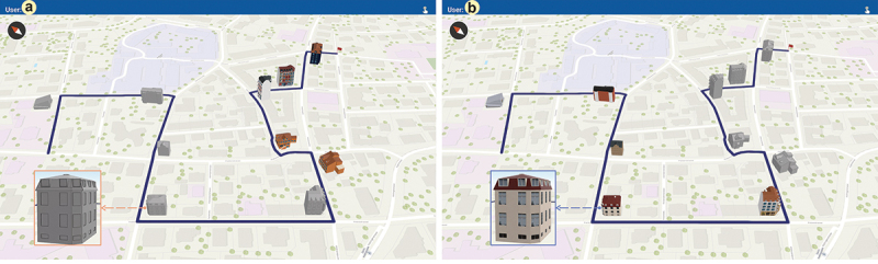
Depicting landmarks on mobile maps is an increasingly popular countermeasure to the negative effect that navigation aids have on spatial learning - landmarks guide visual attention and facilitate map-to-environment information matching. However, the most effective method to visualize landmarks on mobile map aids remains an open question. We conducted a real-world navigation study outdoors to evaluate the influence of realistic vs. abstract 3D landmark visualization styles on wayfinders' navigation performance, visual attention, and spatial learning. While navigating with realistic landmarks, low-spatial-ability wayfinders focused more on the landmarks in the environment and demonstrated improved knowledge of directions between landmarks. Our findings emphasize the importance of visual realism when enriching navigation aids with landmarks to guide attention and enhance spatial learning for low-spatial-ability wayfinders.
Overview
CoChat Summary
TL;DR
In a real-world navigation study, realistic versus abstract 3D landmarks on a mobile map did not change navigation performance, but realistic landmarks increased attention to landmarks and improved some spatial-learning measures for low-spatial-ability wayfinders. Spatial ability and environmental familiarity were consistent predictors, and longer attention to landmarks improved distance estimation regardless of landmark style.
Key findings
- Navigation performance was at ceiling: only 8 wrong turns across 460 navigated intersections and 2 landmark-identification failures; completion time did not differ significantly between realistic and abstract landmark conditions (t(45) = −0.09, p = .9).
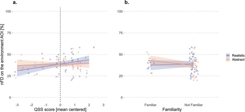
- Realistic landmarks did not significantly affect overall visual attention to the environment, mobile map, or landmarks, but interacted with spatial ability: environment fixation duration increased with QSS score in the realistic condition (emtrend = 2.60, p = .011) but not the abstract condition (emtrend = 0.41, p = .681); landmark fixation duration was higher for low-spatial-ability wayfinders with realistic landmarks (condition × QSS p = .054).
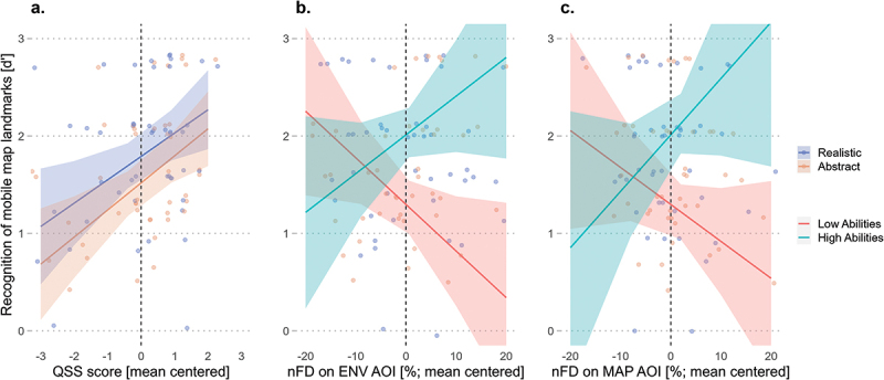
- Direction estimation error improved for low-spatial-ability wayfinders with realistic landmarks (condition × QSS β = 5.21, p = .001; slope contrast β = 10.4, p = .002), while distance estimation improved with longer landmark fixation regardless of visualization style (β = −4.51, p = .006).
- Recognition of environment landmarks was predicted by familiarity (β = 0.17, p = .029) and interacted with condition and fixation duration in the environment (p = .043) and on landmarks (p = .014); route direction recall was predicted by QSS score (β = 0.38, p = .003) and familiarity (β = 0.29, p = .027), not by landmark style. 82.6% of participants preferred the realistic depiction.
Methods
- Within-subject real-world route-following experiment in Zurich, Switzerland: 46 healthy adults (22 females, average age 27.3 years; 24 males, average age 27.8 years; 10 familiar with the area, 36 unfamiliar), navigating an approximately 1 km route with 10 landmarks at intersections, depicted as either abstract or realistic 3D buildings on a mobile map.
- Mobile eye-tracking (Pupil Invisible, 200 Hz) recorded gaze, categorized into environment, mobile map, and landmark areas of interest; spatial learning was assessed with landmark/route knowledge questionnaires, free reconstruction of landmark order, and direction/distance estimation tasks, alongside QSS spatial-ability and PTSOT measures.
- Analyses used linear mixed-effects and generalized linear mixed-effects models in R, signal detection theory d′ for recognition, and post-hoc emmeans tests; an a-priori power analysis indicated a minimum of 40 participants for 83% power.
Limitations
- The paper states that only two landmark depiction styles were tested, and their visual differences may have been too subtle; both may have provided sufficient visuospatial cues for successful navigation.
- The paper states that the study assessed intentional learning, since participants knew their environmental knowledge would be tested, which may have motivated attention and learning regardless of landmark style; future work should examine incidental learning.
- The paper states that environmental familiarity was unbalanced (10 familiar vs. 36 unfamiliar participants), limiting strong conclusions about familiarity effects; evident from the text, the sample was also mostly young adults (mean age about 27.5 years), which may limit generalizability.
Model-written summary. Check it against the paper before relying on it.
Integrity signals
Registry
Cites
Statistics
Figures





Verification
Claims the paper makes
19 Valid · 3 Not valid · 39 Not checked · 120 Own results and interpretations
At least one cited source doesn’t support this claim or points to a different paper, and none confirmed it — see the verdicts below.
In the paper
“and thus are more likely to be prone to negative effects on spatial learning, such as passive reliance on navigation aids and thus lesser engagement with the environment (Dahmani & Bohbot, 2020; Ishikawa, 2019; Ruginski et al., 2019).”
§ The influence of landmark visualization style on task performance, visual attention, and spatial learning in a real-world navigation task > Discussion > Visual attention
What the sources say
- Disputedcites Dahmani & Bohbot, 2020 sourceExperimental — accuracy not yet measured
The Discussion (page unavailable) says GPS use can reduce attention to the environment and impair spatial memory, but it argues against the claimed direction of the relationship. It reports no association between poorer subjective sense of direction and greater GPS use or reliance, and says it is unlikely that people with worse spatial memory used GPS more to compensate. (LLM, conf=0.88)
Checked by a reasoning model — may be wrong.
- Not checked — no full text of the sourcecites Ishikawa, 2019 source
- Not checked — no full text of the sourcecites Ruginski et al., 2019 source
hedgedstates an association- Asserted: passes — The authors put it forward as true.
- Checkable: passes — It can be checked against evidence.
- Load-bearing: unclear — It is unclear whether the paper’s conclusions depend on it.
- Based: passes — The paper gives a reason why it holds.
- Disputed
The cited sources support only part of this claim — read each source’s verdict below.
In the paper
“As attention is attracted by items that differ from their surroundings (Wolfe & Horowitz, 2017), depicting landmarks as realistic 3D building models on a 2D basemap serves as a bottom-up perceptual guidance by stimulus salience, guiding users’ attention to these features (Wolfe & Horowitz, 2017).”
§ The influence of landmark visualization style on task performance, visual attention, and spatial learning in a real-world navigation task > Introduction
What the sources say
- Partly supportedcites Wolfe & Horowitz, 2017 sourceExperimental — accuracy not yet measured
The “Bottom-up guidance by stimulus salience” section says attention can be attracted to items that differ sufficiently from their surroundings along attributes that guide attention. It does not address 3D building models on 2D basemaps or establish that this particular depiction draws users’ attention to landmarks. (LLM, conf=0.86)
plainstates a cause- Asserted: passes — The authors put it forward as true.
- Checkable: passes — It can be checked against evidence.
- Load-bearing: passes — The paper’s conclusions depend on it.
- Based: passes — The paper gives a reason why it holds.
- Partly supported
The cited sources support only part of this claim — read each source’s verdict below.
In the paper
“and thus, the lack of differences in navigation performance is likely because both the abstract and realistic 3D landmark visualization provided the necessary visual information to guide novice wayfinders in a mostly unfamiliar urban environment (Ramanoël et al., 2022).”
§ The influence of landmark visualization style on task performance, visual attention, and spatial learning in a real-world navigation task > Discussion > Navigation performance
What the sources say
- Partly supportedcites Ramanoël et al., 2022 sourceExperimental — accuracy not yet measured
The Results (Behavioral results; page unavailable) report equivalent success rates across three visual-cue conditions in a virtual maze, supporting the general point that different cues can guide navigation equally well by that measure. The study did not compare abstract with realistic 3D landmark visualizations or test novice wayfinders in an unfamiliar urban environment; it also found a navigation-time difference between conditions. (LLM, conf=0.85)
hedgedstates a possible cause- Asserted: passes — The authors put it forward as true.
- Checkable: passes — It can be checked against evidence.
- Load-bearing: passes — The paper’s conclusions depend on it.
- Based: passes — The paper gives a reason why it holds.
- Rests on an assumption not shown here.
- Partly supported
Every source the paper cites for this claim was checked and supports it.
In the paper
“These results indicate that successful navigation is predicted by the ability to attend to relevant landmarks (Chrastil & Warren, 2012; Hamid et al., 2010) and align with previous findings showing that visually salient features improve participants’ spatial memory (Denis et al., 2014; Fine & Minnery, 2009; Keil et al., 2020).”
§ The influence of landmark visualization style on task performance, visual attention, and spatial learning in a real-world navigation task > Discussion > Spatial learning
What the sources say
- Supportedcites Chrastil & Warren, 2012 source
In “Differential attention to environmental properties” (page not provided), the paper states that successful route navigation is related to attending to relevant landmarks rather than being distracted by salient but uninformative objects. This supports the cited paraphrase. (LLM, conf=0.92)
- Supportedcites Hamid et al., 2010 source
The Results report that participants spent the most gaze time on landmarks at corridor ends and junctions, and that removing those landmarks impaired navigation performance. The Discussion says subjects based their performance on the most-fixated landmarks, supporting the claim that attention to relevant landmarks predicts successful navigation. Page numbers were not supplied in the passages. (LLM, conf=0.90)
hedgedstates an association- Asserted: passes — The authors put it forward as true.
- Checkable: passes — It can be checked against evidence.
- Load-bearing: passes — The paper’s conclusions depend on it.
- Based: passes — The paper gives a reason why it holds.
- Supported
The cited sources support only part of this claim — read each source’s verdict below.
In the paper
“Consequently, the rate of spatial knowledge acquisition declines as the mobile map aid reduces the allocation of attentional resources to task-relevant environmental features that are important for spatial learning (Chrastil & Warren, 2012; Gardony et al., 2013, 2015; Hejtmánek et al., 2018; Willis et al., 2009).”
§ The influence of landmark visualization style on task performance, visual attention, and spatial learning in a real-world navigation task > Introduction
What the sources say
- Partly supportedcites Chrastil & Warren, 2012 sourceExperimental — accuracy not yet measured
The Conclusions and future directions section says that attention to relevant environmental properties contributes to route and survey knowledge. The paper does not establish that a mobile map aid reduces that attention or slows the rate of spatial knowledge acquisition. (LLM, conf=0.88)
- Not matchedcites Gardony et al., 2013, 2015
Couldn’t be matched to a paper in Crossref, so it can’t be checked.
- Not checked — no full text of the sourcecites Hejtmánek et al., 2018 source
plainstates a cause- Asserted: passes — The authors put it forward as true.
- Checkable: passes — It can be checked against evidence.
- Load-bearing: passes — The paper’s conclusions depend on it.
- Based: passes — The paper gives a reason why it holds.
- Partly supported
110 more claims · 3 with their cited sources checked
Create a free account to see all 181 claims and to verify the 12 references still open.
- It may state two separate claims as one. 45
- Probably not a substantial claim. 32
- The quote only partly states this claim. 3
Statistics recomputed
Every reported test result, recomputed from its test statistic and degrees of freedom. A result shows as not adding up only once an independent check has confirmed it.
- Consistentt(45) = -0.09reported p = .9 · recomputed p = .929
“t(45) = −0.09, p = .9”
- Consistentz = 1.23reported p = .219 · recomputed p = .219
“z = 1.23, p = .219”
- Consistentz = 2.99reported p = .003 · recomputed p = .003
“z = 2.99, p = .003”
- Consistentz = 2.22reported p = .027 · recomputed p = .026
“z = 2.22, p = .027”
- Consistentz = 0.68reported p = .498 · recomputed p = .497
“z = 0.68, p = .498”
4 more recomputed tests
Create a free account to see every test the Stats check recomputed.
Self-check
Percentages, sums and reported differences re-computed from the paper’s own numbers.
Each contradiction between two passages listed here was confirmed by an independent check.
Rated minor: it would not touch a result — a value no result rests on, a p-value that stays on the same side of the significance level, or a conflict that is clerical, resolved elsewhere in the paper, or outside its own findings.
In the paper
“realistic landmarks (emtrend = 2.60, SE = 0.10, t = 2.61, p = .011)”
§ The influence of landmark visualization style on task performance, visual attention, and spatial learning in a real-world navigation task > Results > Visual attention
Reported 2.61 · recomputed 26
Rated minor: it would not touch a result — a value no result rests on, a p-value that stays on the same side of the significance level, or a conflict that is clerical, resolved elsewhere in the paper, or outside its own findings.
In the paper
§ The influence of landmark visualization style on task performance, visual attention, and spatial learning in a real-world navigation task > Results > Spatial learning
“Table: Table 9. The distance estimation error is predicted by the nFD on the landmark AOI. | Predictors | Direction estimation error [angular degree] Estimate | Direction estimation error [angular degree] Std. Error | Direction estimation error [angular degree] t-value | Direction estimation error [angular degree] p-value |”
§ The influence of landmark visualization style on task performance, visual attention, and spatial learning in a real-world navigation task > Results > Spatial learning
“Distance estimation among REL landmarks was analyzed using an LME with the distance estimation error expressed in meters as the response variable”
Rated minor: it would not touch a result — a value no result rests on, a p-value that stays on the same side of the significance level, or a conflict that is clerical, resolved elsewhere in the paper, or outside its own findings.
In the paper
“| Familiarity [Familiar] | 0.54 | 0.26 | 2.21 | .034 |”
§ The influence of landmark visualization style on task performance, visual attention, and spatial learning in a real-world navigation task > Results > Spatial learning
Reported 2.21 · recomputed 2.076923
Rated minor: it would not touch a result — a value no result rests on, a p-value that stays on the same side of the significance level, or a conflict that is clerical, resolved elsewhere in the paper, or outside its own findings.
In the paper
§ The influence of landmark visualization style on task performance, visual attention, and spatial learning in a real-world navigation task > Results > Spatial learning
“the visualization condition and the recognition of landmarks sequence as seen during the wayfinding task (β = 0.17, SE = 0.25, z = 0.68, p = .498; Table 7)”
§ The influence of landmark visualization style on task performance, visual attention, and spatial learning in a real-world navigation task > Results > Spatial learning
“| Condition [Realistic] | 0.12 | 0.23 | 0.50 | .619 |”
Rated minor: it would not touch a result — a value no result rests on, a p-value that stays on the same side of the significance level, or a conflict that is clerical, resolved elsewhere in the paper, or outside its own findings.
In the paper
“abstract landmarks (emtrend = 0.41, SE = 0.10, t = 0.41, p = .681)”
§ The influence of landmark visualization style on task performance, visual attention, and spatial learning in a real-world navigation task > Results > Visual attention
Reported 0.41 · recomputed 4.1
Citations
Cites
Fitting Linear Mixed-Effects Models Using lme4
Bates, D., Mächler, M., Bolker, B., & Walker, S. (2015) · Journal of Statistical Software · doi:10.18637/jss.v067.i01 · Cited by 86,835 · cited 1×
“LME and GLME models were implemented in R (v.4.2.1) using the lme4 package (Bates et al., 2015).”
MethodInfluentialWickham, H. (2016) · Use R! · doi:10.1007/978-3-319-24277-4 · Cited by 33,115
Delorme, A., & Makeig, S. (2004) · Journal of Neuroscience Methods · doi:10.1016/j.jneumeth.2003.10.009 · Cited by 24,371 · cited 1×
“1; Delorme & Makeig, 2004), and these fixations received the AOI label of the underlying raw gaze samples.”
BackgroundlmerTest Package: Tests in Linear Mixed Effects Models
Kuznetsova, A., Brockhoff, P. B., & Christensen, R. H. B. (2017) · Journal of Statistical Software · doi:10.18637/jss.v082.i13 · Cited by 24,346 · cited 1×
“…for the models and the post-hoc analyses were calculated using the Satterthwaite approximation for degrees of freedom, as it produces acceptable levels of Type I error (Luke, 2017; Singmann & Kellen, 2019), implemented using the summary() function of the lmerTest package (Kuznetsova et al., 2017).”
MethodDevelopment of NASA-TLX (Task Load Index): Results of Empirical and Theoretical Research
(1988) · Advances in Psychology · doi:10.1016/s0166-4115(08)62386-9 · Cited by 15,003 · cited 1×
“Electroencephalography (EEG) and NASA Task Load Index (NASA TLX; Hart & Staveland, 1988) were recorded to address a different research question beyond the scope of the present study and thus will not be mentioned further.”
MethodRandom effects structure for confirmatory hypothesis testing: Keep it maximal
Barr, D. J., Levy, R., Scheepers, C., & Tily, H. J. (2013) · Journal of Memory and Language · doi:10.1016/j.jml.2012.11.001 · Cited by 10,328 · cited 1×
“To identify the statistical model that would converge for each dependent variable, we started with a model that includes the dependent variable as a response variable with no fixed effects and a maximal random effect structure imposed by the experimental design (Barr et al., 2013).”
MethodEye Tracking: A comprehensive guide to methods and measures
Holmqvist, K., Nyström, M., Andersson, R., Dewhurst, R. J., Jarodzka, H. M., & van de Weijer, J. (2015) · Lund University Publications (Lund University) · Cited by 2,919
SIMR : an R package for power analysis of generalized linear mixed models by simulation
Green, P., & MacLeod, C. J. (2016) · Methods in Ecology and Evolution · doi:10.1111/2041-210x.12504 · Cited by 2,467 · cited 1×
“We conducted an a-priori power analysis for a single-predictor multilevel linear regression model (DeBruine & Barr, 2021) using the simr package (Green et al., 2016) for data simulation in R (v.4.2.1).”
MethodInfluentialThe Development of Spatial Representations of Large-Scale Environments
Siegel, A. W., & White, S. H. (1975) · Advances in Child Development and Behavior · doi:10.1016/s0065-2407(08)60007-5 · Cited by 1,830 · cited 6×
“These findings are not surprising and align with previous work suggesting that wayfinders’ spatial knowledge formation increases with increased environmental exposure (Montello, 1998; Siegel & White, 1975).”
BackgroundMethodResultInfluentialEvaluating significance in linear mixed-effects models in R
Luke, S. G. (2017) · Behavior Research Methods · doi:10.3758/s13428-016-0809-y · Cited by 1,704 · cited 1×
“…for the models and the post-hoc analyses were calculated using the Satterthwaite approximation for degrees of freedom, as it produces acceptable levels of Type I error (Luke, 2017; Singmann & Kellen, 2019), implemented using the summary() function of the lmerTest package (Kuznetsova et al., 2017).”
Method
Cited by
Cognitive issues of mobile map design and use
Griffin, A. L., Reichenbacher, T., Liao, H., Wang, W., & Cao, Y. (2024) · Journal of Location Based Services · doi:10.1080/17489725.2024.2371288 · Cited by 27
Hilton, C. W., Kapaj, A., & Fabrikant, S. I. (2024) · Attention Perception & Psychophysics · doi:10.3758/s13414-024-02864-z · Cited by 17
“To further investigate this limitation, we analyzed the spatial knowledge of those participants and found no effects of familiarity on route knowledge (see companion article; Kapaj et al., 2023a).”
InfluentialSelf-citationFallibilism and Generative AI in Cartography: Some Fundamental Theoretical Thoughts
Edler, D., Drews, J., Berr, K., & Kühne, O. (2025) · KN - Journal of Cartography and Geographic Information · doi:10.1007/s42489-025-00186-0 · Cited by 13
“…experimental research in cartography, which often focuses on cognitive processes in the interpretation of maps (cf. Dickmann et al. 2024; Kapaj et al. 2024; Roth et al. 2017), needs to develop and establish methodological approaches that reconcile the fallibility of AI-based…”
Simplifying complex landmark models with holes for 3D maps: a topological perception-based approach
Ding, Y., Chen, D., Sisi Zlatanova, B., Wu, M., Cao, K., Song, Y., & Yang, Y. (2025) · International Journal of Geographical Information Systems · doi:10.1080/13658816.2025.2512222 · Cited by 3
“2023, Kapaj et al .”
Towards neuroadaptive navigation assistance to reduce spatial de-skilling
Fabrikant, S. I. (2024) · Cognitive Processing · doi:10.1007/s10339-024-01209-w · Cited by 3
“To empirically study this, we have begun to employ passive neurocognitive human in-situ sensing (mEEG) coupled with mET to assess users’ visual attention (Brügger et al. 2019) and cognitive load during mGID-assisted navigation outdoors (Hilton et al. 2024; Kapaj et al. 2024) (Fig.”
BackgroundMethodInfluentialSelf-citation
Metadata
- Authors
- Kapaj, A., Hilton, C., Lanini-Maggi, S., & Fabrikant, S. I.
- Affiliations
- University of Zurich (CH)
- Corresponding author
- Kapaj, Armand
- Venue
- Spatial Cognition & Computation
- Publisher
- Informa UK Limited
- Published
- 2024-03-13
- Volume
- 24
- Issue
- 4
- Pages
- 227-267
- ISSN
- 1387-5868 (ISSN-L)
- 1542-7633
- PMC
- PMC11537298
- OpenAlex
- W4392760837
- Cited by
- 20
- References
- 104
- Citations by year
- 2026: 11 · 2025: 6 · 2024: 3
- FWCI
- 2.15
- Type
- journal article
- Language
- en
- Open access
- hybrid
- doi.org
- Licence
- Locations
- Spatial Cognition and Computation (publishedVersion, cc-by)
- PubMed Central (publishedVersion, cc-by)
- PubMed (publishedVersion)
- Zurich Open Repository and Archive (University of Zurich) (submittedVersion, cc-by)
- Funders
- H2020 European Research Council (Advanced Grant GeoViSense)
- Topics
- Social Sciences › Psychology › Experimental and Cognitive Psychology › Spatial Cognition and Navigation
- Social Sciences › Geography, Planning and Development › Geography Education and Pedagogy
- Social Sciences › Geography, Planning and Development › Geographic Information Systems Studies
- Keywords
- mobile maps, wayfinding, spatial learning, visual attention, navigation aids, spatial ability, outdoor navigation
About these checks
Registry, retraction, Cites and statistics results are computed, not judged, with one exception: a printed reference that no index lists is read once by a model before it counts as a citation error. Claims are extracted by a model and kept only when their quote appears verbatim in the text; each cited source is then checked, with a model’s help, for whether it says what the claim relies on. Those verdicts can be wrong — read the claim’s quote and the cited source before relying on one.
The claim verdicts this report counts are experimental: their accuracy is not yet measured.
A language model drew the claims from the paper on 2026-10-10, under version 3 of the claim definition (model deepseek-v4.1-flash, prompt extract-v3).
A second model labelled each claim on 2026-10-10 (model jev-1.13-20260917, definition revision gold-guideline-v0.2).
Cited sources are checked with a language model’s help (gpt-6-sol).
Statistics and arithmetic are recomputed, not judged.
Confidence bands are shown only for fields calibrated on our annotated test set. None is calibrated yet, so no band is shown.
What counts as a claim ›How we measure confidence ›How we check this ›
Are you an author, or do you see a problem with this page? Request a review
How to cite
Cite CoChat for the checks on this page, and the paper for its own findings.
- This page
- CoChat. (2026). Citation check: The influence of landmark visualization style on task performance, visual attention, and spatial learning in a real-world navigation task. https://app.cochat.ai/papers/10.1080/13875868.2024.2328099
- The paper
- Kapaj, A., Hilton, C., Lanini-Maggi, S., & Fabrikant, S. I. (2024). The influence of landmark visualization style on task performance, visual attention, and spatial learning in a real-world navigation task. Spatial Cognition & Computation. https://doi.org/10.1080/13875868.2024.2328099
Data sources
Bibliographic data: Semantic Scholar, OpenAlex, Crossref.
Contains information from the Semantic Scholar Academic Graph Datasets, made available under the ODC Attribution License (ODC-BY 1.0).
Semantic Scholar’s data is described in: Kinney, R., et al. (2023). The Semantic Scholar Open Data Platform. arXiv:2301.10140.
