

SoilGrids250m: Global gridded soil information based on machine learning
Open accessThe DOI matches its Crossref record; 85 of the 89 references it cites were found in a registry or an index.
Abstract
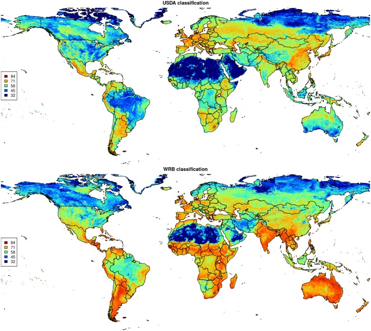
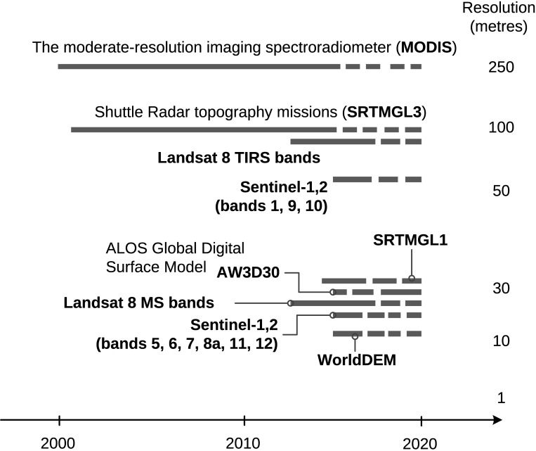
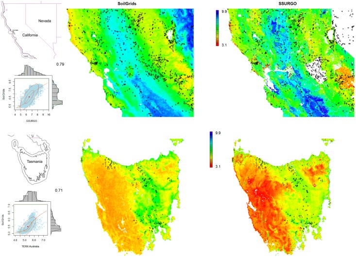
This paper describes the technical development and accuracy assessment of the most recent and improved version of the SoilGrids system at 250m resolution (June 2016 update). SoilGrids provides global predictions for standard numeric soil properties (organic carbon, bulk density, Cation Exchange Capacity (CEC), pH, soil texture fractions and coarse fragments) at seven standard depths (0, 5, 15, 30, 60, 100 and 200 cm), in addition to predictions of depth to bedrock and distribution of soil classes based on the World Reference Base (WRB) and USDA classification systems (ca. 280 raster layers in total). Predictions were based on ca. 150,000 soil profiles used for training and a stack of 158 remote sensing-based soil covariates (primarily derived from MODIS land products, SRTM DEM derivatives, climatic images and global landform and lithology maps), which were used to fit an ensemble of machine learning methods-random forest and gradient boosting and/or multinomial logistic regression-as implemented in the R packages ranger, xgboost, nnet and caret. The results of 10-fold cross-validation show that the ensemble models explain between 56% (coarse fragments) and 83% (pH) of variation with an overall average of 61%. Improvements in the relative accuracy considering the amount of variation explained, in comparison to the previous version of SoilGrids at 1 km spatial resolution, range from 60 to 230%. Improvements can be attributed to: (1) the use of machine learning instead of linear regression, (2) to considerable investments in preparing finer resolution covariate layers and (3) to insertion of additional soil profiles. Further development of SoilGrids could include refinement of methods to incorporate input uncertainties and derivation of posterior probability distributions (per pixel), and further automation of spatial modeling so that soil maps can be generated for potentially hundreds of soil variables. Another area of future research is the development of methods for multiscale merging of SoilGrids predictions with local and/or national gridded soil products (e.g. up to 50 m spatial resolution) so that increasingly more accurate, complete and consistent global soil information can be produced. SoilGrids are available under the Open Data Base License.
Overview
The claims and statistics of this paper haven’t been checked yet.
Free: it reads the open-access text and checks the first 5 claims that cite a source we can check. Create a free account to check every claim.
Integrity signals
Registry
Cites
Statistics
Figures






Verification
Claims the paper makes
The claims and statistics of this paper haven’t been checked yet.
Free: it reads the open-access text and checks the first 5 claims that cite a source we can check. Create a free account to check every claim.
Claims other papers make about this one
Each is checked against this paper’s own text: does it say what the citing paper says it does?
The source backs part of the claim, not all of it — or backs it for a different population, condition or comparison.
In the citing paper
“These uncertainties are mostly due to the uneven distribution and overall scarcity of field data for modelling and validating carbon stocks in the biomass and soil 27,64,65 .”
From Global priority areas for ecosystem restoration (2020) · cites this paper as [65]
Experimental — accuracy not yet measured
Self-check
Percentages, sums and reported differences re-computed from the paper’s own numbers.
The self-check needs the paper’s full text.
Citations
Cites
XGBoost: A Scalable Tree Boosting System
Chen, T., & Guestrin, C. (2016) · Proceedings of the 22nd ACM SIGKDD International Conference on Knowledge Discovery and Data Mining · doi:10.1145/2939672.2939785 · Cited by 54,569
Modern Applied Statistics with S
Venables, W. N., & Ripley, B. D. (2002) · Statistics and Computing · doi:10.1007/978-0-387-21706-2 · Cited by 24,305
Very high resolution interpolated climate surfaces for global land areas
Hijmans, R. J., Cameron, S. E., Parra, J. L., Jones, P. G., & Jarvis, A. (2005) · International Journal of Climatology · doi:10.1002/joc.1276 · Cited by 19,825
Total Carbon, Organic Carbon, and Organic Matter
Nelson, D. W., & Sommers, L. E. (1982) · Agronomy Monographs · doi:10.2134/agronmonogr9.2.2ed.c29 · Cited by 9,978
Building Predictive Models in R Using the caret Package
Kuhn, M. (2008) · Journal of Statistical Software · doi:10.18637/jss.v028.i05 · Cited by 8,863
Weighted kappa: nominal scale agreement provision for scaled disagreement or partial credit
Cohen, J. (1968) · Psychological Bulletin · doi:10.1037/h0026256 · Cited by 8,736
Kuhn, M., & Johnson, K. (2013) · doi:10.1007/978-1-4614-6849-3 · Cited by 6,788
Communication in the presence of noise
Shannon, C. E. (1949) · Proceedings of the IRE · doi:10.1109/jrproc.1949.232969 · Cited by 6,539
Anonim, A. (2010) · Cited by 4,945
Communication In The Presence Of Noise
Shannon, C. E. (1998) · Proceedings of the IEEE · doi:10.1109/jproc.1998.659497 · Cited by 4,804
ranger: A Fast Implementation of Random Forests for High Dimensional Data in C++ and R
Wright, M. N., & Ziegler, A. (2017) · Journal of Statistical Software · doi:10.18637/jss.v077.i01 · Cited by 3,340
Self-citationROCR: visualizing classifier performance in R
Sing, T., Sander, O., Beerenwinkel, N., & Lengauer, T. (2005) · Bioinformatics · doi:10.1093/bioinformatics/bti623 · Cited by 3,200
Status and distribution of mangrove forests of the world using earth observation satellite data
Giri, C., Ochieng, E., Tieszen, L. L., Zhu, Z., Singh, A., Loveland, T., Masek, J., & Duke, N. (2011) · Global Ecology and Biogeography · doi:10.1111/j.1466-8238.2010.00584.x · Cited by 3,171
raster: Geographic Data Analysis and Modeling
Hijmans, R. J. (2010) · CRAN: Contributed Packages · doi:10.32614/cran.package.raster · Cited by 2,907
System for Automated Geoscientific Analyses (SAGA) v. 2.1.4
Conrad, O., Bechtel, B., Bock, M., Dietrich, H., Fischer, E., Gerlitz, L., Wehberg, J., Wichmann, V., & Böhner, J. (2015) · Geoscientific Model Development · doi:10.5194/gmd-8-1991-2015 · Cited by 2,614
Global land cover mapping at 30 m resolution: A POK-based operational approach
Chen, J., Chen, J., Liao, A., Cao, X., Chen, L., Chen, X., He, C., Han, G., Peng, S., Lu, M., et al. (2015) · ISPRS Journal of Photogrammetry and Remote Sensing · doi:10.1016/j.isprsjprs.2014.09.002 · Cited by 2,049
Krämer, W. (2003) · Computational Statistics & Data Analysis · Cited by 1,858
Rabus, B., Eineder, M., Roth, A., & Bamler, R. (2003) · ISPRS Journal of Photogrammetry and Remote Sensing · doi:10.1016/s0924-2716(02)00124-7 · Cited by 1,820
Factors of Soil Formation: A System of Quantitative Pedology
Pendleton, R. L., & Jenny, H. (1945) · Geographical Review · doi:10.2307/211491 · Cited by 1,748
Global soil carbon: understanding and managing the largest terrestrial carbon pool
Scharlemann, J. P., Tanner, E. V., Hiederer, R., & Kapos, V. (2014) · Carbon Management · doi:10.4155/cmt.13.77 · Cited by 1,612
Meinshausen, N. (2006) · Cited by 1,521
Global Patterns of Groundwater Table Depth
Fan, Y., Li, H., & Miguez-Macho, G. (2013) · Science · doi:10.1126/science.1229881 · Cited by 1,312
Klein Goldewijk, K., Beusen, A., van Drecht, G., & de Vos, M. (2011) · Global Ecology and Biogeography · doi:10.1111/j.1466-8238.2010.00587.x · Cited by 1,270
SoilGrids1km — Global Soil Information Based on Automated Mapping
Hengl, T., de Jesus, J. M., MacMillan, R. A., Batjes, N. H., Heuvelink, G. B. M., Ribeiro, E., Samuel-Rosa, A., Kempen, B., Leenaars, J. G. B., Walsh, M. G., et al. (2014) · PLoS ONE · doi:10.1371/journal.pone.0105992 · Cited by 1,268
Self-citationGlobal multi-resolution terrain elevation data 2010 (GMTED2010)
Danielson, J. J., & Gesch, D. B. (2011) · Open-File Report · doi:10.3133/ofr20111073 · Cited by 1,181
Hartmann, J., & Moosdorf, N. (2012) · Geochemistry, Geophysics, Geosystems · doi:10.1029/2012gc004370 · Cited by 1,159
Harmonized World Soil Database version 2.0
(2023) · doi:10.4060/cc3823en · Cited by 1,064
A conditioned Latin hypercube method for sampling in the presence of ancillary information
Minasny, B., & McBratney, A. B. (2006) · Computers & Geosciences · doi:10.1016/j.cageo.2005.12.009 · Cited by 1,038
Hengl, T., Heuvelink, G. B. M., Kempen, B., Leenaars, J. G. B., Walsh, M. G., Shepherd, K. D., Sila, A., MacMillan, R. A., Mendes de Jesus, J., Tamene, L., et al. (2015) · PLOS ONE · doi:10.1371/journal.pone.0125814 · Cited by 935
Self-citationHarmonized World Soil Database (version 1.2)
Nachtergaele, F., van Velthuizen, H., Verelst, L., Wiberg, D. A., Batjes, N. H., Dijkshoorn, J. A., van Engelen, V. W. P., Fischer, G., Jones, A., Montanarella, L., et al. (2012) · Socio-Environmental Systems Modeling · Cited by 905
Self-citationAccuracy assessment of the MODIS snow products
Hall, D. K., & Riggs, G. A. (2007) · Hydrological Processes · doi:10.1002/hyp.6715 · Cited by 836
System for Automated Geoscientific Analyses (SAGA) v. 2.1.4Preprint
Conrad, O., Bechtel, B., Bock, M., et al. (2015) · doi:10.5194/gmdd-8-2271-2015 · Cited by 758
Classes and Methods for Spatial Data
Pebesma, E. J., & Bivand, R. (2015) · Cited by 719
A China data set of soil properties for land surface modeling
Shangguan, W., Dai, Y., Liu, B., Zhu, A., Duan, Q., Wu, L., Ji, D., Ye, A., Yuan, H., Zhang, Q., et al. (2013) · Journal of Advances in Modeling Earth Systems · doi:10.1002/jame.20026 · Cited by 688
Self-citationStatnikov, A., Wang, L., & Aliferis, C. F. (2008) · BMC Bioinformatics · doi:10.1186/1471-2105-9-319 · Cited by 686
Sanchez, P. A., Ahamed, S., Carré, F., Hartemink, A. E., Hempel, J., Huising, J., Lagacherie, P., McBratney, A. B., McKenzie, N. J., Mendonça-Santos, M. D. L., et al. (2009) · Science · doi:10.1126/science.1175084 · Cited by 643
The GLIMS geospatial glacier database: A new tool for studying glacier change
Raup, B., Racoviteanu, A., Khalsa, S. J. S., Helm, C., Armstrong, R., & Arnaud, Y. (2007) · Global and Planetary Change · doi:10.1016/j.gloplacha.2006.07.018 · Cited by 516
Guidelines for soil profile description.
Rome (1977) · Cited by 492
Sampling for validation of digital soil maps
Brus, D. J., Kempen, B., & Heuvelink, G. B. M. (2011) · European Journal of Soil Science · doi:10.1111/j.1365-2389.2011.01364.x · Cited by 415
Self-citationMapping the global depth to bedrock for land surface modeling
Shangguan, W., Hengl, T., Mendes de Jesus, J., Yuan, H., & Dai, Y. (2017) · Journal of Advances in Modeling Earth Systems · doi:10.1002/2016ms000686 · Cited by 412
Self-citationArrouays, D., Grundy, M. G., Hartemink, A. E., Hempel, J. W., Heuvelink, G. B. M., Hong, S. Y., Lagacherie, P., Lelyk, G., McBratney, A. B., McKenzie, N. J., et al. (2014) · Advances in Agronomy · doi:10.1016/b978-0-12-800137-0.00003-0 · Cited by 396
Self-citationA new global raster water mask at 250 m resolution
Carroll, M. L., Townshend, J. R., DiMiceli, C. M., Noojipady, P., & Sohlberg, R. A. (2009) · International Journal of Digital Earth · doi:10.1080/17538940902951401 · Cited by 368
Learning with Ensembles: How over-fitting can be useful
Peter Sollich, A., & Krogh, A. (1995) · Cited by 353
Hugelius, G., Tarnocai, C., Broll, G., Canadell, J. G., Kuhry, P., & Swanson, D. K. (2013) · Earth System Science Data · doi:10.5194/essd-5-3-2013 · Cited by 352
Pelletier, J. D., Broxton, P. D., Hazenberg, P., Zeng, X., Troch, P. A., Niu, G., Williams, Z., Brunke, M. A., & Gochis, D. (2016) · Journal of Advances in Modeling Earth Systems · doi:10.1002/2015ms000526 · Cited by 326
Global soil organic carbon assessment
Stockmann, U., Padarian, J., McBratney, A., Minasny, B., de Brogniez, D., Montanarella, L., Hong, S. Y., Rawlins, B. G., & Field, D. J. (2015) · Global Food Security · doi:10.1016/j.gfs.2015.07.001 · Cited by 321 · cited 2×
“f̄ (x) = ∑ M k=1 wk · fk(x) ∑k=1 wk , wk = 1 σ2 k,CV (2)”
BackgroundSoil mapping, classification, and pedologic modeling: History and future directions
Brevik, E. C., Calzolari, C., Miller, B. A., Pereira, P., Kabala, C., Baumgarten, A., & Jordán, A. (2016) · Geoderma · doi:10.1016/j.geoderma.2015.05.017 · Cited by 321
Digital Soil Mapping and Modeling at Continental Scales: Finding Solutions for Global Issues
Grunwald, S., Thompson, J. A., & Boettinger, J. L. (2011) · Soil Science Society of America Journal · doi:10.2136/sssaj2011.0025 · Cited by 309
Terra and Aqua MODIS products available from NASA GES DAAC
Savtchenko, A., Ouzounov, D., Ahmad, S., Acker, J., Leptoukh, G., Koziana, J., & Nickless, D. (2004) · Advances in Space Research · doi:10.1016/j.asr.2004.03.012 · Cited by 284
Batjes, N. H. (2009) · Soil Use and Management · doi:10.1111/j.1475-2743.2009.00202.x · Cited by 269
Self-citationCollection-5 MODIS Land Surface Temperature Products Users' Guide
Wan, Z. (2006) · Cited by 262
Spatio‐temporal interpolation of daily temperatures for global land areas at 1 km resolution
Kilibarda, M., Hengl, T., Heuvelink, G. B. M., Gräler, B., Pebesma, E., Perčec Tadić, M., & Bajat, B. (2014) · Journal of Geophysical Research: Atmospheres · doi:10.1002/2013jd020803 · Cited by 260
Self-citationUncertainty in soil data can outweigh climate impact signals in global crop yield simulations
Folberth, C., Skalský, R., Moltchanova, E., Balkovič, J., Azevedo, L. B., Obersteiner, M., & van der Velde, M. (2016) · Nature Communications · doi:10.1038/ncomms11872 · Cited by 246
Near-global freshwater-specific environmental variables for biodiversity analyses in 1 km resolution
Domisch, S., Amatulli, G., & Jetz, W. (2015) · Scientific Data · doi:10.1038/sdata.2015.73 · Cited by 214
National versus global modelling the 3D distribution of soil organic carbon in mainland France
Mulder, V. L., Lacoste, M., Richer-de-Forges, A. C., Martin, M. P., & Arrouays, D. (2016) · Geoderma · doi:10.1016/j.geoderma.2015.08.035 · Cited by 197
MaxEnt versus MaxLike: empirical comparisons with ant species distributions
Fitzpatrick, M. C., Gotelli, N. J., & Ellison, A. M. (2013) · Ecosphere · doi:10.1890/es13-00066.1 · Cited by 186
Fundamentals in Information Theory and Coding
Borda, M. (2011) · Springer eBooks · doi:10.1007/978-3-642-20347-3 · Cited by 161
Shani, U., Ben‐Gal, A., Tripler, E., & Dudley, L. M. (2007) · Water Resources Research · doi:10.1029/2006wr005313 · Cited by 159
A Handbook of Soil Terminology, Correlation and Classification
(2009) · Routledge eBooks · doi:10.4324/9781849774352 · Cited by 158
Using model averaging to combine soil property rasters from legacy soil maps and from point data
Malone, B., Minasny, B., Odgers, N. P., & McBratney, A. B. (2014) · Geoderma · doi:10.1016/j.geoderma.2014.04.033 · Cited by 154
Global governance of soil resources as a necessary condition for sustainable development
Montanarella, L., & Rojas, R. V. (2012) · Current Opinion in Environmental Sustainability · doi:10.1016/j.cosust.2012.06.007 · Cited by 123
A New Map of Global Ecological Land Units — An Ecophysiographic Stratification Approach.
Sayre, R. G., Dangermond, J., Frye, C., Vaughan, R., Aniello, P., Breyer, S., Cribbs, D., Hopkins, D., Nauman, R. S., Derrenbacher, B., et al. (2014) · Digital Access to Libraries · doi:10.13140/2.1.2167.8887 · Cited by 119
Gasch, C. K., Tomislav Hengl, A., Gräler, B., Meyer, H., Magney, T. S., & Brown, D. J. (2015) · Spatial Statistics · doi:10.1016/j.spasta.2015.04.001 · Cited by 116
LUCAS Topoil Survey - methodology, data and results
Tóth, G., Arwyn, J., Montanarella, L., Alewell, C., Ballabio, C., Carré, F., Delphine, D. B., Guicharnaud, R., Gardi, C., Hermann, T., et al. (2013) · Joint Research Centre (European Commission) · doi:10.2788/97922 · Cited by 115
ranger: A Fast Implementation of Random Forests
Wright, M. N. (2015) · CRAN: Contributed Packages · doi:10.32614/cran.package.ranger · Cited by 106
Self-citationOptimisation of global grids for high-resolution remote sensing data
Bauer-Marschallinger, B., Sabel, D., & Wagner, W. (2014) · Computers & Geosciences · doi:10.1016/j.cageo.2014.07.005 · Cited by 98
Self-citationGriffiths, R. I., Thomson, B. C., Plassart, P., Gweon, H. S., Stone, D., Creamer, R., Lemanceau, P., & Bailey, M. (2015) · Applied Soil Ecology · doi:10.1016/j.apsoil.2015.06.018 · Cited by 86
Mira, M., Weiss, M., Baret, F., Courault, D., Hagolle, O., Gallego-Elvira, B., & Olioso, A. (2015) · Remote Sensing of Environment · doi:10.1016/j.rse.2015.09.021 · Cited by 84
Land health surveillance and response: A framework for evidence-informed land management
Shepherd, K. D., Shepherd, G., & Walsh, M. (2014) · Agricultural Systems · doi:10.1016/j.agsy.2014.09.002 · Cited by 79
A National Soil Profile Database for Brazil Available to International Scientists
Cooper, M., Mendes, L. M. S., Silva, W. L. C., & Sparovek, G. (2005) · Soil Science Society of America Journal · doi:10.2136/sssaj2004.0140 · Cited by 75
Wiley, P., Doi, I., Kellner, E., Michael, S., Baird, A., Borlange, M. A., Leeds, L., WADDINGTON, J. M., & Of, S. (2007) · Springer eBooks · doi:10.1007/978-0-387-75510-6_5 · Cited by 70
Easier parallel computing in R with snowfall and sfCluster
Knaus, J., Porzelius, C., Binder, H., & Schwarzer, G. (2009) · The R Journal · doi:10.32614/rj-2009-004 · Cited by 61
Combining Soil Databases for Topsoil Organic Carbon Mapping in Europe
Aksoy, E., Yiğini, Y., & Montanarella, L. (2016) · PLoS ONE · doi:10.1371/journal.pone.0152098 · Cited by 54 · cited 2×
“Sandc[%] = Sand (Sand+Silt+Clay) ·100 (3)”
BackgroundLáng, V., Fuchs, M., Waltner, I., & Michéli, E. (2012) · Geoderma · doi:10.1016/j.geoderma.2012.07.023 · Cited by 52
Eighty-metre resolution 3D soil-attribute maps for Tasmania, Australia
Kidd, D. B., Webb, M., Malone, B., Minasny, B., & McBratney, A. B. (2015) · Soil Research · doi:10.1071/sr14268 · Cited by 47
Pogson, M., Hastings, A., & Smith, P. (2011) · Environmental Modelling & Software · doi:10.1016/j.envsoft.2011.10.008 · Cited by 41
The Australian site data collation to support the GlobalSoilMap
Searle, R. (2014) · CRC Press eBooks · doi:10.1201/b16500-26 · Cited by 29
Multiple Browsers Structure Tree Recruitment in Logged Temperate Forests
Faison, E. K., DeStefano, S., Foster, D. R., Rapp, J. M., & Compton, J. A. (2016) · PLoS ONE · doi:10.1371/journal.pone.0166783 · Cited by 20
Leenaars, J. G. B. (2013) · Socio-Environmental Systems Modeling · Cited by 20
Self-citationRibeiro, E., Batjes, N. H., Leenaars, J. G. B., van Oostrum, A. J. M., & de Jesus, J. S. M. (2015) · Cited by 20
Self-citationBiophysical Land Suitability for Oil Palm in Kalimantan, Indonesia
Mantel, S., Wösten, H., & Verhagen, A. (2007) · Socio-Environmental Systems Modeling · Cited by 15
Self-citationTowards the standardization and harmonization of world soil data
Ribeiro, E., Batjes, N. H., Leenaars, J. G. B., Oostrum, V. A. J. M., & de Jesus, J. S. M. (2015) · Cited by 14
Self-citationJagger, J., Perry, N., & Sestoft, P. (2007) · Elsevier eBooks · doi:10.1016/b978-012372511-0.50013-8 · Cited by 9
Brevik, E. C., Baumgarten, A., Calzolari, C., Jordán, A., Kabała, C., Miller, B. A., & Pereira, P. A. D. S. (2015) · Geoderma · doi:10.1016/j.geoderma.2015.09.022 · Cited by 8
Baade, J., & Schmullius, C. (2014) · IEEE International Geoscience and Remote Sensing Symposium (IGARSS) · doi:10.1109/igarss.2014.6947447 · Cited by 5
Research works printed but not linked: 5
- D Arrouays, 2014, Soil carbon. vol. 125 of Advances in Agronomy, 93
- SA Lei, 1998, Soil Properties of the Kelso Sand Dunes in the Mojave Desert, The Southwestern Naturalist, 43, 47
- Huffman GJ, Bolvin DT. GPCP version 2 combined precipitation data set documentation. vol. 1. Laboratory for Atmospheres, NASA Goddard Space Flight Center and Science Systems and Applications; 2009.
- Kempen B. Updating soil information with digital soil mapping [PhD thesis]. Wageningen University. Wageningen; 2011. Available from: http://edepot.wur.nl/187198.
- Eberhardt E. Deriving WRB soil types using National German Soil Survey Guidelines. In: NCSS National Conference. NCSS Standards. Asheville, NC: United States Department of Agriculture USDA-NRCS; 2011. p. 1–2.
Cited by
Deep learning and process understanding for data-driven Earth system science
Reichstein, M., Camps-Valls, G., Stevens, B., Jung, M., Denzler, J., Carvalhais, N., & Prabhat (2019) · Nature · doi:10.1038/s41586-019-0912-1 · Cited by 5,673
SoilGrids 2.0: producing soil information for the globe with quantified spatial uncertainty
Poggio, L., de Sousa, L. M., Batjes, N. H., Heuvelink, G. B. M., Kempen, B., Ribeiro, E., & Rossiter, D. (2021) · SOIL · doi:10.5194/soil-7-217-2021 · Cited by 2,333
Self-citationA global atlas of the dominant bacteria found in soil
Delgado-Baquerizo, M., Oliverio, A. M., Brewer, T. E., Benavent-González, A., Eldridge, D. J., Bardgett, R. D., Maestre, F. T., Singh, B. K., & Fierer, N. (2018) · Science · doi:10.1126/science.aap9516 · Cited by 2,301
The global tree restoration potential
Bastin, J.-F., Finegold, Y., Garcia, C., Mollicone, D., Rezende, M., Routh, D., Zohner, C. M., & Crowther, T. W. (2019) · Science · doi:10.1126/science.aax0848 · Cited by 2,197
Rainfall–runoff modelling using Long Short-Term Memory (LSTM) networks
(2018) · doi:10.5194/hess-22-6005-2018 · Cited by 2,114
“In their study, Hsu et al. (1997) compared a RNN to a traditional ANN. Even though the traditional ANN in general performed equally well, they found that the number of delayed inputs, which are provided as driving inputs to the ANN, is a critical hyperparameter. However, the RNN, due to its architecture, made the sear…”
MethodResult
Metadata
- Authors
- Hengl, T., Mendes de Jesus, J., Heuvelink, G. B. M., Ruiperez Gonzalez, M., Kilibarda, M., Blagotić, A., Shangguan, W., Wright, M. N., Geng, X., Bauer-Marschallinger, B., Guevara, M. A., Vargas, R., MacMillan, R. A., Batjes, N. H., Leenaars, J. G. B., Ribeiro, E., Wheeler, I., Mantel, S., & Kempen, B.
- Affiliations
- ISRIC - World Soil Information (NL)
- University of Belgrade (RS)
- Sun Yat-sen University (CN)
- University of Lübeck (DE)
- Agriculture and Agri-Food Canada (CA)
- TU Wien (AT)
- University of Delaware (US)
- ORCID
- Venue
- PLOS ONE
- Publisher
- Public Library of Science (PLoS)
- Published
- 2017-02-16
- Volume
- 12
- Issue
- 2
- Pages
- e0169748
- ISSN
- 1932-6203 (ISSN-L)
- PMC
- PMC5313206
- OpenAlex
- W2588003345
- Cited by
- 4,733
- References
- 89
- Citations by year
- 2026: 591 · 2025: 654 · 2024: 610 · 2023: 634 · 2022: 669 · 2021: 672 · 2020: 402 · 2019: 265 · 2018: 173 · 2017: 56
- FWCI
- 137.14
- Type
- journal article
- Language
- en
- Open access
- gold
- doi.org
- Licence
- Locations
- PLoS ONE (publishedVersion, cc-by)
- PubMed Central (publishedVersion, cc-by)
- PubMed (publishedVersion)
- RePEc: Research Papers in Economics (submittedVersion)
- DOAJ (DOAJ: Directory of Open Access Journals) (submittedVersion)
- GraFar (University of Belgrade, Faculty of Civil Engineering) (submittedVersion, cc-by)
- Socio-Environmental Systems Modeling (submittedVersion, cc-by)
- Data Archiving and Networked Services (DANS) (submittedVersion, other-oa)
- Topics
- Life Sciences › Agricultural and Biological Sciences › Soil Science › Soil Geostatistics and Mapping
- Physical Sciences › Environmental Science › Environmental Engineering › Soil Moisture and Remote Sensing
- Physical Sciences › Environmental Science › Management, Monitoring, Policy and Law › Soil and Land Suitability Analysis
- Keywords
- SoilGrids, soil properties, soil organic carbon, soil bulk density, cation exchange capacity, soil pH, soil texture, coarse fragments, bedrock depth, soil classification, USDA soil classification, MODIS, random forest, gradient boosting, multinomial logistic regression, ensemble learning, accuracy assessment, soil mapping
- MeSH terms
- Machine Learning, Algorithms, Conservation of Natural Resources, Environmental Monitoring, Humans, Models, Theoretical, Soil, Geographic Information Systems
About these checks
Registry, retraction, Cites and statistics results are computed, not judged, with one exception: a printed reference that no index lists is read once by a model before it counts as a citation error. Claims are extracted by a model and kept only when their quote appears verbatim in the text; each cited source is then checked, with a model’s help, for whether it says what the claim relies on. Those verdicts can be wrong — read the claim’s quote and the cited source before relying on one.
Statistics and arithmetic are recomputed, not judged.
Confidence bands are shown only for fields calibrated on our annotated test set. None is calibrated yet, so no band is shown.
What counts as a claim ›How we measure confidence ›How we check this ›
Are you an author, or do you see a problem with this page? Request a review
Data sources
Bibliographic data: Semantic Scholar, OpenAlex, Crossref.
Contains information from the Semantic Scholar Academic Graph Datasets, made available under the ODC Attribution License (ODC-BY 1.0).
Semantic Scholar’s data is described in: Kinney, R., et al. (2023). The Semantic Scholar Open Data Platform. arXiv:2301.10140.
