

The DOI matches its Crossref record; 133 of the 133 references it cites were found in a registry or an index; 11 of the 84 sources its claims cite were checked for support.
Pre‐contact and post‐colonial ecological legacies shape Surinamese rainforests
Open accessAbstract
Disturbances in tropical forests can have long-lasting ecological impacts, but their manifestations (ecological legacies) in modern forests are uncertain. Many Amazonian forests bear the mark of past soil modifications, species enrichments, and fire events, but the trajectories of ecological legacies from the pre-contact or post-colonial period remain relatively unexplored. We assessed the fire and vegetation history from 15 soil cores ranging from 0 to 10 km from a post-colonial Surinamese archaeological site. We show that (1) fires occurred from 96 bc to recent times and induced significant vegetation change, (2) persistent ecological legacies from pre-contact and post-colonial fire and deforestation practices were mainly within 1 km of the archaeological site, and (3) palm enrichment of Attalea, Oenocarpus and Astrocaryum occurred within 0, 1, and 8 km of the archaeological site, respectively. Our results challenge the notion of spatially extensive and persistent ecological legacies. Instead, our data indicate that the persistence and extent of ecological legacies are dependent on their timing, frequency, type, and intensity. Examining the mechanisms and manifestations of ecological legacies is crucial in assessing forest resilience and Indigenous and local land rights in the highly threatened Amazonian forests.
Overview
AI snapshot
Written from the paper’s full text.
TL;DR
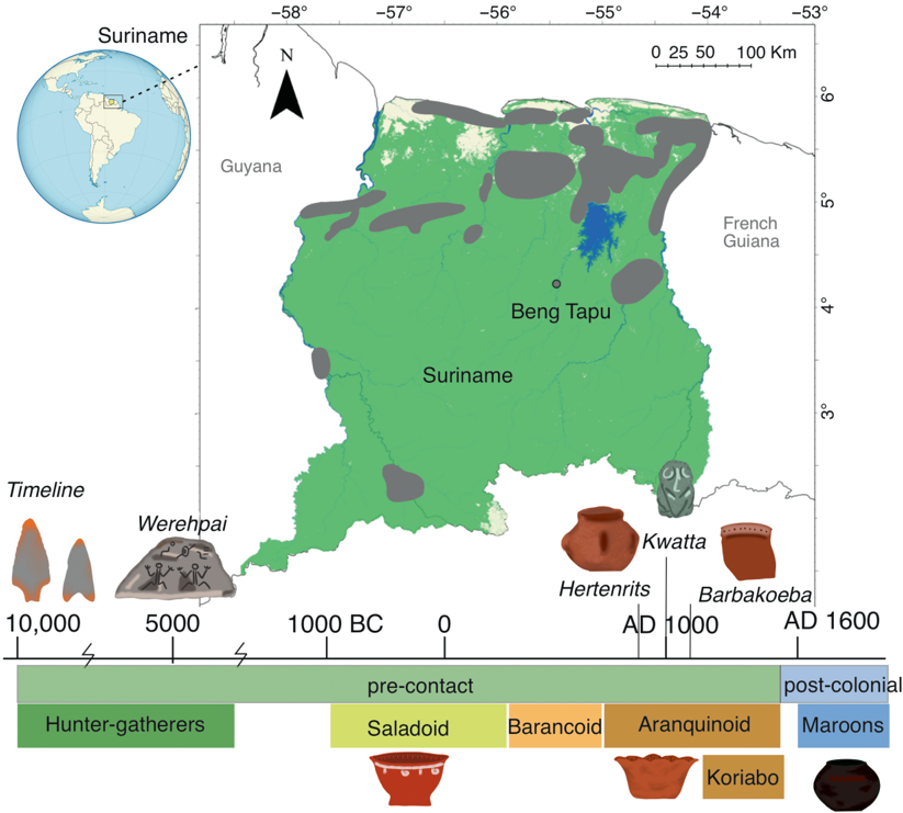
This study uses charcoal and phytolith records from 15 soil cores around the post-colonial Surinamese archaeological site Beng Tapu to test how far pre-contact and post-colonial ecological legacies extend. It finds that persistent legacies were mostly localized within 1 km, while some fire and vegetation changes occurred 6–8 km away, challenging assumptions of spatially extensive Amazonian legacies.
Key findings
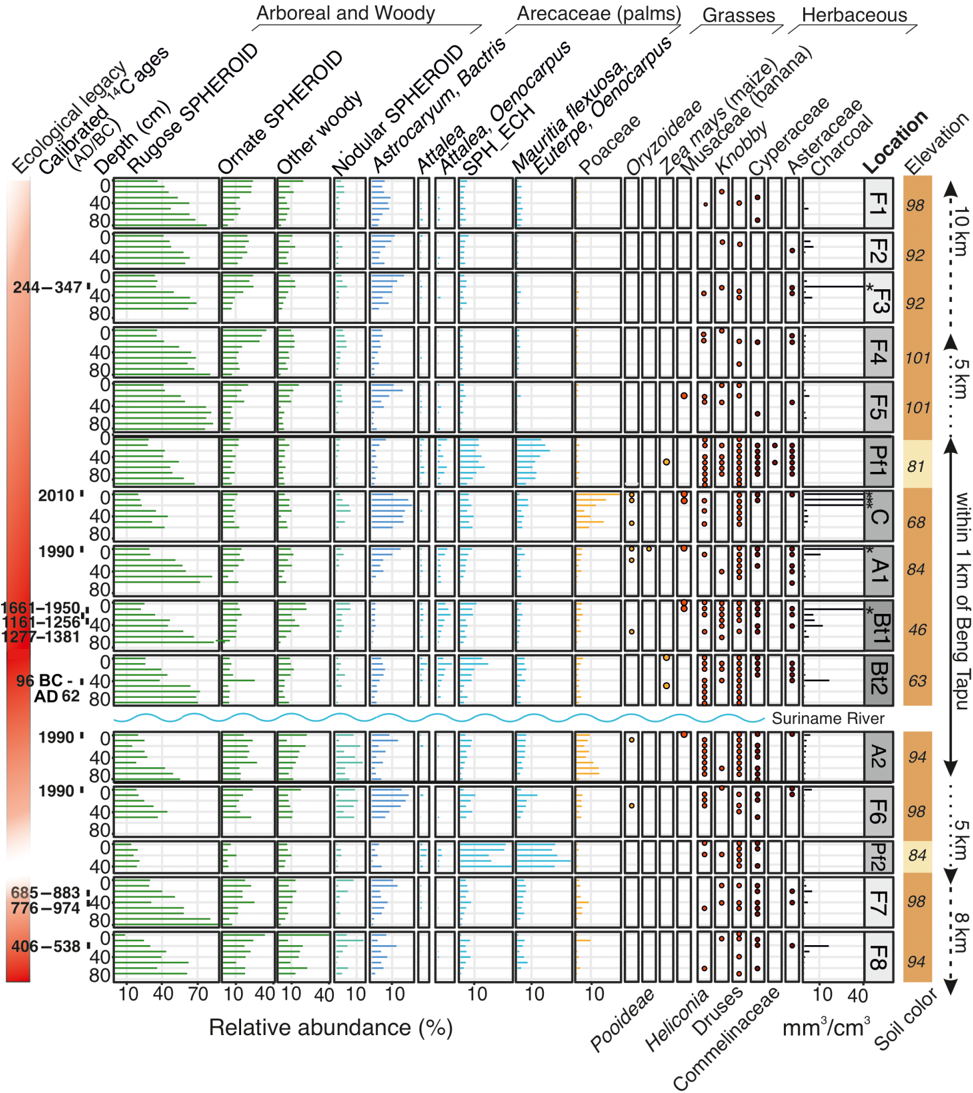
- Charcoal occurred in 84 of 117 samples and all 15 soil cores; 12 radiocarbon-dated fragments showed fires from 96 BC to modern times, with 7 pre-contact dates (96 BC–AD 1381) and 5 post-colonial dates (AD 1661–modern). Large charcoal volumes >10 mm³/cm³ were recovered within 1 km of Beng Tapu.
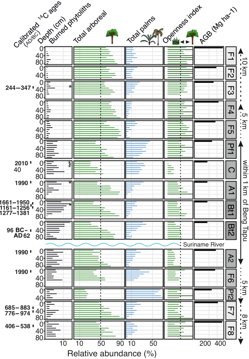
- Maize phytoliths occurred only within 1 km of Beng Tapu (soil cores BT2 and Pf1), while banana phytoliths occurred up to 5 km away (F5, C, A1, BT1, A2). Modern aboveground biomass was lowest (<200 Mg/ha) within 1 km, ranged 284–404 Mg/ha within 5 km, and 274–433 Mg/ha >5 km away.
- Palm enrichment was spatially structured: Attalea, Oenocarpus, and Astrocaryum increased within 0, 1, and 8 km of the archaeological site, respectively. SPH_ECH palm phytoliths increased within 1 km, and Astrocaryum/Bactris increased within 8 km in soil cores with charcoal.
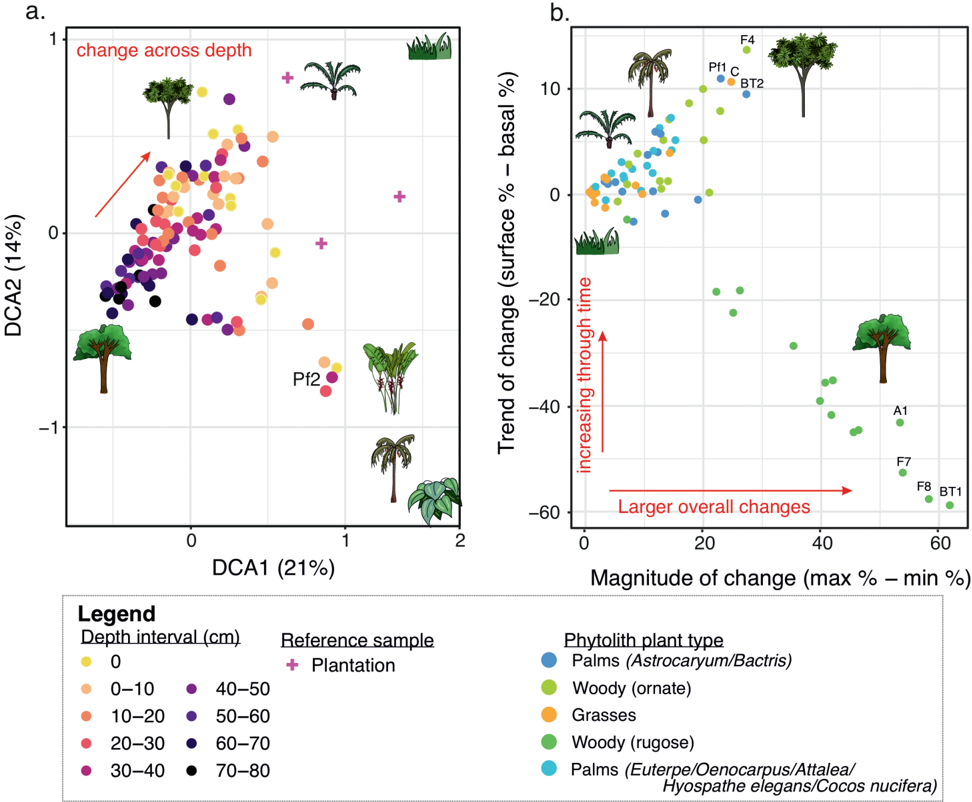
- Fire and forest opening were not restricted to the site vicinity: elevated grass abundances and charcoal occurred at F7 and F8 (6 and 8 km away), and high charcoal >10 mm³/cm³ occurred at F3 (6 km) without forest-opening evidence. The largest vegetation changes occurred at BT1, A1, F7, and F8, not simply by distance from Beng Tapu.
Methods
- Two 10-km transects radiated from the Beng Tapu archaeological site in Sipaliwini, Suriname; soil cores were collected at 250 m, 500 m, and 1, 2, 4, 8, and 10 km, with samples at 10-cm intervals to 80 cm depth. In total, 15 surface samples and 102 soil-core samples (N = 117) were analyzed for phytoliths and charcoal.
- Phytoliths were extracted using standard procedures, counted to a minimum of 200 arboreal and 400 total phytoliths, and assigned to 20 morphotype/taxonomic groups. Charcoal volume was calculated from photographed fragments using ImageJ.
- Twelve charcoal fragments were AMS radiocarbon dated and calibrated with IntCal20. Detrended correspondence analysis (DCA) assessed phytolith assemblage dissimilarity, and trend/magnitude of change was calculated for five common phytolith groups; openness index and modern aboveground biomass estimates were compared across sites.
Limitations
- The paper states that no pre-contact settlements have been investigated in the vicinity of the study region, limiting interpretation of the pre-contact period, and that archaeological studies in Suriname’s forested interior are scarce. It also notes that not all samples were dated, that modern deforestation and agricultural activities make past human impacts difficult to determine at soil cores C, A1, and A2, and that phytoliths can move downward in soils; soil core C may have been exposed to erosion or overturning from recent slash-and-burn.
- The paper states that the F7 and F8 sites may be close to a yet-undiscovered pre-contact occupation site, so those distant fire signals are interpreted indirectly rather than from known archaeological context.
- Evident from the text: the pre-contact and post-colonial interpretations rely on a relatively small number of dated charcoal fragments (N = 12) and on soil-core records without comprehensive independent archaeological dating at every sampled location.
Model-written summary. Check it against the paper before relying on it.
Integrity signals
Registry
Cites
Statistics
Figures
Verification
Claims the paper makes
32 Own result · 17 Sources not found · 16 Own interpretation · 14 Not checked yet · 6 No basis given · 5 No full text of the sources · 4 Partly supported · 3 Supported so far · 1 Couldn’t confirm · 1 Own method · accuracy not yet measured
The sources with a verdict support this claim; the rest weren’t checked yet, have no full text we could read, or their verdicts aren’t rated yet.
In the paper
“Fire can cause severe and persistent ecological consequences”
§ Pre-contact and post-colonial ecological legacies shape Surinamese rainforests > INTRODUCTION
What the sources say
- Not checked — no full text of the sourcecites Åkesson et al., 2023 source
- Supportedcites Barlow & Peres, 2008 source
The Conclusion reports that fires drastically alter Amazonian forest structure and composition and are likely to have long-term effects on tree species composition. The Discussion also describes severe changes after repeated fires. These passages support the broad claim that fire can have severe and persistent ecological consequences. (LLM, conf=0.94)
- Supportedcites Bodin et al., 2020 source
The section ‘Vegetation cover and wood selection and uses’ (page unavailable) describes liana forests as possible remnants of past fire disturbance and says lianas can prevent forest regeneration. The Conclusions (page unavailable) describe profound changes in vegetation and forest resilience at some formerly occupied sites. Together, these passages support the qualified claim that fire can have severe, persistent ecological consequences. (LLM, conf=0.84)
plaindirect- Asserted: passes — The authors put it forward as true.
- Checkable: passes — It can be checked against evidence.
- Load-bearing: passes — The paper’s conclusions depend on it.
- Based: passes — The paper gives a reason why it holds.
The cited sources support only part of this claim — read each source’s verdict below.
In the paper
“Direct species enrichment and depletion have also occurred for the last centuries to millennia”
§ Pre-contact and post-colonial ecological legacies shape Surinamese rainforests > INTRODUCTION
What the sources say
- Partly supportedcites Balée, 1993 sourceExperimental — accuracy not yet measured
The summary on p. 231 says indigenous agroforestry may have enhanced regional plant diversity, and p. 232 says plant management in Amazonia is probably more than five thousand years old. The cited passages do not establish direct species depletion over that period; the discussion of harmful effects on p. 232 presents and critiques another author's view. (LLM, conf=0.83)
- Not matchedcites Clement, 1988
Couldn’t be matched to a paper in Crossref, so it can’t be checked.
- Partly supportedcites Clement et al., 2015 sourceExperimental — accuracy not yet measured
Section 2, “Plant management and domestication” (page unavailable), says people promoted useful plants and animals, altered forest composition, and left effects visible at centennial and millennial scales. This supports species enrichment over the stated timescale, but the passages do not establish direct species depletion. (LLM, conf=0.84)
plaindirect- Asserted: passes — The authors put it forward as true.
- Checkable: passes — It can be checked against evidence.
- Load-bearing: passes — The paper’s conclusions depend on it.
- Based: passes — The paper gives a reason why it holds.
- Partly supported
The cited sources support only part of this claim — read each source’s verdict below.
In the paper
“These data highlight the significant impact that fire can have on vegetation turnover in tropical forests”
§ Pre-contact and post-colonial ecological legacies shape Surinamese rainforests > DISCUSSION
What the sources say
- Not matchedcites Barlow et al., 2003
Couldn’t be matched to a paper in Crossref, so it can’t be checked.
- Supportedcites Barlow & Peres, 2008 source
Section 6 (Evaluating the savannization paradigm) explicitly lists rapid compositional turnover among the changes brought about by fire. The Conclusion likewise reports that fires drastically alter forest composition in the Brazilian Amazon, supporting the claim that fire can significantly affect vegetation turnover in tropical forests. (LLM, conf=0.94)
plaindirect- Asserted: passes — The authors put it forward as true.
- Checkable: passes — It can be checked against evidence.
- Load-bearing: passes — The paper’s conclusions depend on it.
- Based: passes — The paper gives a reason why it holds.
- Not matched
The cited sources support only part of this claim — read each source’s verdict below.
In the paper
“Charcoal from pre-contact burning events that occurred centuries apart suggests there were multiple occupations within the region before European colonization, aligning with patterns seen in other Amazonian studies”
§ Pre-contact and post-colonial ecological legacies shape Surinamese rainforests > DISCUSSION
What the sources say
- Partly supportedcites Arroyo-Kalin, 2010 sourceExperimental — accuracy not yet measured
In the section discussing Amazonian dark earth chronology (Figures 1–2; page unavailable), the paper says charcoal dates indicate habitation-related soil enrichment over centuries, while stratified remains in thick soil horizons indicate two or more overlapping occupations. It does not specifically identify burning events centuries apart as the evidence for those separate occupations. (LLM, conf=0.82)
- Not matchedcites Arroyo-Kalin & Riris, 2021
Couldn’t be matched to a paper in Crossref, so it can’t be checked.
- Partly supportedcites Lins et al., 2015 sourceExperimental — accuracy not yet measured
The Material and Methods section (Design and archaeological context; page unavailable) describes at least two stratigraphically distinct pre-Columbian occupations at three sites, supporting the inference of multiple occupations. It identifies ceramic traditions and dating by radiocarbon or comparison with other sites, but does not describe charcoal from burning events centuries apart as the evidence for them. (LLM, conf=0.87)
hedgedcorrelationaln = 12- Asserted: passes — The authors put it forward as true.
- Checkable: passes — It can be checked against evidence.
- Load-bearing: passes — The paper’s conclusions depend on it.
- Based: passes — The paper gives a reason why it holds.
- Partly supported
The cited sources that could be checked couldn’t confirm or dispute this claim.
In the paper
“An explanation for the high abundance of Euterpe oleraceae may be local edaphic and hydrological conditions, as Euterpe oleraceae reportedly grows near creeks and in swampy areas”
§ Pre-contact and post-colonial ecological legacies shape Surinamese rainforests > DISCUSSION
What the sources say
- Not checked — no full text of the sourcecites Johnston, 1998 source
- Could not verifycites Ter Steege et al., 2013 sourceExperimental — accuracy not yet measured
Table 1 (Research Article; page not given) lists Euterpe oleracea as abundant in Amazonia, but does not describe where it grows. The forest-type discussion (page not given) also does not say it grows near creeks or in swampy areas. Searches for those habitats and for flooded forests found no passage supporting the habitat explanation attributed to this source. (LLM, conf=0.72)
- Not matchedcites van Andel, 2000
Couldn’t be matched to a paper in Crossref, so it can’t be checked.
hedgedconditional- Asserted: passes — The authors put it forward as true.
- Checkable: passes — It can be checked against evidence.
- Load-bearing: unclear — It is unclear whether the paper’s conclusions depend on it.
- Based: passes — The paper gives a reason why it holds.
A result the paper reports from its own data — it cites no other source for it, so there is none to check. The quote shows it is in the paper.
In the paper
“palm enrichment of Attalea, Oenocarpus and Astrocaryum occurred within 0, 1, and 8 km of the archaeological site, respectively”
- Also stated in: § RESULTS · plain
“Third, phytoliths from Astryocaryum or Bactris increased within 8 km of the archaeological site, in soil cores where charcoal occurred.”
§ Pre-contact and post-colonial ecological legacies shape Surinamese rainforests > Abstract
plaincorrelational- Asserted: passes — The authors put it forward as true.
- Checkable: passes — It can be checked against evidence.
- Load-bearing: passes — The paper’s conclusions depend on it.
- Based: passes — The paper gives a reason why it holds.
- Also stated in: § RESULTS · plain
A result the paper reports from its own data — it cites no other source for it, so there is none to check. The quote shows it is in the paper.
In the paper
“palm enrichment of Attalea, Oenocarpus and Astrocaryum occurred within 0, 1, and 8 km of the archaeological site, respectively”
- Also stated in: § RESULTS · plain
“Second, SPH_ECH phytoliths produced by Euterpe, Oenocarpus, Attalea, Hyospathe elegans or Cocos nucifera increased within 1 km of the archaeological site.”
§ Pre-contact and post-colonial ecological legacies shape Surinamese rainforests > Abstract
plaincorrelational- Asserted: passes — The authors put it forward as true.
- Checkable: passes — It can be checked against evidence.
- Load-bearing: passes — The paper’s conclusions depend on it.
- Based: passes — The paper gives a reason why it holds.
- Also stated in: § RESULTS · plain
A result the paper reports from its own data — it cites no other source for it, so there is none to check. The quote shows it is in the paper.
In the paper
“Radiocarbon-dated charcoal fragments (N = 12) from soil cores indicated that fires occurred between 96 BC and modern times”
- Also stated in: § Abstract · plain
“fires occurred from 96 BC to recent times”
§ Pre-contact and post-colonial ecological legacies shape Surinamese rainforests > RESULTS
plainn = 12- Asserted: passes — The authors put it forward as true.
- Checkable: passes — It can be checked against evidence.
- Load-bearing: passes — The paper’s conclusions depend on it.
- Based: passes — The paper gives a reason why it holds.
- Also stated in: § Abstract · plain
A result the paper reports from its own data — it cites no other source for it, so there is none to check. The quote shows it is in the paper.
In the paper
“palm enrichment of Attalea, Oenocarpus and Astrocaryum occurred within 0, 1, and 8 km of the archaeological site, respectively”
- Also stated in: § RESULTS · plain
“First, Attalea and Oenocarpus (specific) palm phytoliths increased at the archaeological site.”
§ Pre-contact and post-colonial ecological legacies shape Surinamese rainforests > Abstract
plaincorrelational- Asserted: passes — The authors put it forward as true.
- Checkable: passes — It can be checked against evidence.
- Load-bearing: unclear — It is unclear whether the paper’s conclusions depend on it.
- Based: passes — The paper gives a reason why it holds.
- Also stated in: § RESULTS · plain
A result the paper reports from its own data — it cites no other source for it, so there is none to check. The quote shows it is in the paper.
In the paper
“Banana phytoliths occurred within 5 km of the site at soil cores F5, C, A1, BT1, and A2.”
§ Pre-contact and post-colonial ecological legacies shape Surinamese rainforests > RESULTS
plain- Asserted: passes — The authors put it forward as true.
- Checkable: passes — It can be checked against evidence.
- Load-bearing: unclear — It is unclear whether the paper’s conclusions depend on it.
- Based: passes — The paper gives a reason why it holds.
- It may state two separate claims as one. 39
- Probably not a substantial claim. 14
The sources with a verdict support this claim; the rest weren’t checked yet, have no full text we could read, or their verdicts aren’t rated yet.
In the paper
“Fire in Amazonian forests (today and in the past) is mainly associated with human activities as many forests are too wet for natural ignitions to spread”
§ Pre-contact and post-colonial ecological legacies shape Surinamese rainforests > INTRODUCTION
What the sources say
- Supportedcites Bush et al., 2008 source
The Introduction (§1a) says the vast majority of Amazonian fires are sparked by humans and predicts that past fires were primarily associated with human disturbance. It also says natural fires are very rare in mesic forests and that, under normal moisture conditions, fires in moderately seasonal forests generally burn out rather than spreading. (LLM, conf=0.93)
- Not checked — no full text of the sourcecites Cochrane, 2003 source
- Not matchedcites Cochrane & Schulze, 1998
Couldn’t be matched to a paper in Crossref, so it can’t be checked.
plaincorrelational- Asserted: passes — The authors put it forward as true.
- Checkable: passes — It can be checked against evidence.
- Load-bearing: unclear — It is unclear whether the paper’s conclusions depend on it.
- Based: passes — The paper gives a reason why it holds.
It may state two separate claims as one.
- Supported
The cited sources support only part of this claim — read each source’s verdict below.
In the paper
“Previous studies have shown that the upper 20 cm of soil cores may encompass pre-contact and post-colonial periods”
§ Pre-contact and post-colonial ecological legacies shape Surinamese rainforests > DISCUSSION
What the sources say
- Not matchedcites Heijink et al., 2023
Couldn’t be matched to a paper in Crossref, so it can’t be checked.
- Partly supportedcites McMichael et al., 2022 sourceExperimental — accuracy not yet measured
The Fire history section reports pre-contact charcoal dates and one modern date, and says charcoal was most abundant in the upper 10 cm. The Vegetation change section discusses samples from 0–20 cm, but our copy does not establish that this depth interval contains material from both pre-contact and post-colonial periods. (LLM, conf=0.75)
- Not checked — no full text of the sourcecites Piperno et al., 2021 source
hedged- Asserted: passes — The authors put it forward as true.
- Checkable: passes — It can be checked against evidence.
- Load-bearing: passes — The paper’s conclusions depend on it.
- Based: passes — The paper gives a reason why it holds.
Probably not a substantial claim.
- Not matched
The sources with a verdict support this claim; the rest weren’t checked yet, have no full text we could read, or their verdicts aren’t rated yet.
In the paper
“Modern studies have shown that logging has impacted forest succession for decades”
§ Pre-contact and post-colonial ecological legacies shape Surinamese rainforests > DISCUSSION
What the sources say
- Not checked — no full text of the sourcecites De Graaf et al., 1999 source
- Not matchedcites Dekker & De Graaf, 2003
Couldn’t be matched to a paper in Crossref, so it can’t be checked.
- Supportedcites Landburg et al., 2021 source
The Management implications section reports that an influx of secondary species after logging was still evident approximately 30 years later. The Medium and long term effects section also describes logging-related changes in vegetation composition, supporting the claim about decades-long effects on forest succession. (LLM, conf=0.93)
plaindirect- Asserted: passes — The authors put it forward as true.
- Checkable: passes — It can be checked against evidence.
- Load-bearing: fails — The paper’s conclusions may not depend on it.
- Based: passes — The paper gives a reason why it holds.
Probably not a substantial claim. The paper’s conclusions may not depend on it.
A result the paper reports from its own data — it cites no other source for it, so there is none to check. The quote shows it is in the paper.
In the paper
“Seven dated fragments were obtained from within 1 km of the Beng Tapu archaeological site, where large charcoal volumes >10 mm 3 /cm 3 were recovered.”
§ Pre-contact and post-colonial ecological legacies shape Surinamese rainforests > RESULTS
plain- Asserted: passes — The authors put it forward as true.
- Checkable: passes — It can be checked against evidence.
- Load-bearing: unclear — It is unclear whether the paper’s conclusions depend on it.
- Based: passes — The paper gives a reason why it holds.
It may state two separate claims as one.
A result the paper reports from its own data — it cites no other source for it, so there is none to check. The quote shows it is in the paper.
In the paper
“Although phytoliths from Knobby, Heliconia, and Asteraceae were present across the transect, these morphotypes were identified in most samples from soil cores within 1 km of Beng Tapu, while occurring only once or twice in a soil core >1 km away from Beng Tapu”
§ Pre-contact and post-colonial ecological legacies shape Surinamese rainforests > RESULTS
plaincorrelational- Asserted: passes — The authors put it forward as true.
- Checkable: passes — It can be checked against evidence.
- Load-bearing: passes — The paper’s conclusions depend on it.
- Based: passes — The paper gives a reason why it holds.
It may state two separate claims as one.
A result the paper reports from its own data — it cites no other source for it, so there is none to check. The quote shows it is in the paper.
In the paper
“Within 1 km of Beng Tapu, arboreal abundances were <50% and openness values <10”
§ Pre-contact and post-colonial ecological legacies shape Surinamese rainforests > RESULTS
plainSingle case- Asserted: passes — The authors put it forward as true.
- Checkable: passes — It can be checked against evidence.
- Load-bearing: passes — The paper’s conclusions depend on it.
- Based: passes — The paper gives a reason why it holds.
It may state two separate claims as one.
A result the paper reports from its own data — it cites no other source for it, so there is none to check. The quote shows it is in the paper.
In the paper
“For other soil cores between 2 and 10 km of the archaeological site, openness values decreased from basal to top samples but ranged between 10 and 664 (values >10 indicate forested settings).”
§ Pre-contact and post-colonial ecological legacies shape Surinamese rainforests > RESULTS
plaincorrelational- Asserted: passes — The authors put it forward as true.
- Checkable: passes — It can be checked against evidence.
- Load-bearing: unclear — It is unclear whether the paper’s conclusions depend on it.
- Based: passes — The paper gives a reason why it holds.
It may state two separate claims as one.
In the paper
“Our results support this hypothesis and show that Astrocaryum palms increased in soil cores with past fire events and in the area where modern shifting cultivation occurs”
§ Pre-contact and post-colonial ecological legacies shape Surinamese rainforests > DISCUSSION
What the sources say
- Not matchedcites Appendix S1: Figure S1
Couldn’t be matched to a paper in Crossref, so it can’t be checked.
plaindirect- Asserted: passes — The authors put it forward as true.
- Checkable: passes — It can be checked against evidence.
- Load-bearing: passes — The paper’s conclusions depend on it.
- Based: passes — The paper gives a reason why it holds.
It may state two separate claims as one.
- Not matched
A result the paper reports from its own data — it cites no other source for it, so there is none to check. The quote shows it is in the paper.
In the paper
“Radiocarbon dating from excavations at Beng Tapu revealed that colonial metal, soft paste earthenware potsherds, and hard-paste ceramics recovered in a charcoal lens confirmed that Beng Tapu is the traditional territory of the Saamaka Maroons who settled in the late 17th century and remain so to this day”
§ Pre-contact and post-colonial ecological legacies shape Surinamese rainforests > DISCUSSION
plainSingle case- Asserted: passes — The authors put it forward as true.
- Checkable: passes — It can be checked against evidence.
- Load-bearing: passes — The paper’s conclusions depend on it.
- Based: passes — The paper gives a reason why it holds.
It may state two separate claims as one.
A result the paper reports from its own data — it cites no other source for it, so there is none to check. The quote shows it is in the paper.
In the paper
“Charcoal was present in 84 of the 117 samples, and in all 15 soil cores, however 52 samples contained minute amounts (<1 mm 3 /cm 3 ; Figure 2).”
§ Pre-contact and post-colonial ecological legacies shape Surinamese rainforests > RESULTS
plainn = 117- Asserted: passes — The authors put it forward as true.
- Checkable: passes — It can be checked against evidence.
- Load-bearing: passes — The paper’s conclusions depend on it.
- Based: passes — The paper gives a reason why it holds.
It may state two separate claims as one.
A result the paper reports from its own data — it cites no other source for it, so there is none to check. The quote shows it is in the paper.
In the paper
“Interestingly, both palm-dominated forests (Pf1, Pf2) contained soils that appeared white and sandy instead of orange and clay, suggesting higher sand concentrations than other locations”
§ Pre-contact and post-colonial ecological legacies shape Surinamese rainforests > DISCUSSION
hedgedcorrelational- Asserted: passes — The authors put it forward as true.
- Checkable: passes — It can be checked against evidence.
- Load-bearing: passes — The paper’s conclusions depend on it.
- Based: passes — The paper gives a reason why it holds.
It may state two separate claims as one.
In the paper
“This location was dominated by Euterpe oleraceae, a hyperdominant species widely used to build houses and fences, as food and juice (van Andel & Ruysschaert, 2014), and was located near a vegetation marker for archaeological sites (a Ceiba pentandra tree).”
§ Pre-contact and post-colonial ecological legacies shape Surinamese rainforests > DISCUSSION
What the sources say
- Not matchedcites van Andel & Ruysschaert, 2014
Couldn’t be matched to a paper in Crossref, so it can’t be checked.
plainSingle case- Asserted: passes — The authors put it forward as true.
- Checkable: passes — It can be checked against evidence.
- Load-bearing: unclear — It is unclear whether the paper’s conclusions depend on it.
- Based: passes — The paper gives a reason why it holds.
It may state two separate claims as one.
- Not matched
A result the paper reports from its own data — it cites no other source for it, so there is none to check. The quote shows it is in the paper.
In the paper
“Finally, ornate SPHEROID increased between 5 and 10 km of Beng Tapu and rugose SPHEROID decreased in all soil cores except Pf2”
§ Pre-contact and post-colonial ecological legacies shape Surinamese rainforests > RESULTS
plaindirect- Asserted: passes — The authors put it forward as true.
- Checkable: passes — It can be checked against evidence.
- Load-bearing: unclear — It is unclear whether the paper’s conclusions depend on it.
- Based: passes — The paper gives a reason why it holds.
It may state two separate claims as one.
The paper states this without a source or data behind it here, so there is nothing to check it against. The quote shows it is in the paper.
In the paper
“Burning events and forest openings were not restricted to areas close to Beng Tapu as hypothesized, but were also found at 6 and 8 km distance from the site”
§ Pre-contact and post-colonial ecological legacies shape Surinamese rainforests > DISCUSSION
plain- Asserted: passes — The authors put it forward as true.
- Checkable: passes — It can be checked against evidence.
- Load-bearing: passes — The paper’s conclusions depend on it.
- Based: passes — The paper gives a reason why it holds.
It may state two separate claims as one.
The paper states this without a source or data behind it here, so there is nothing to check it against. The quote shows it is in the paper.
In the paper
“In contrast, however, palm phytoliths did not increase at Pf2 but remained high at every depth.”
§ Pre-contact and post-colonial ecological legacies shape Surinamese rainforests > RESULTS
plainSingle case- Asserted: passes — The authors put it forward as true.
- Checkable: passes — It can be checked against evidence.
- Load-bearing: unclear — It is unclear whether the paper’s conclusions depend on it.
- Based: passes — The paper gives a reason why it holds.
It may state two separate claims as one.
None of the sources cited for this claim have been checked yet.
In the paper
“Within 5 km of Beng Tapu, where post-colonial cultivation practices have occurred, AGB estimates ranged between 284 and 404 Mg/ha and overlapped with AGB estimates >5 km away (274-433 Mg/ha), all values that fell within the range of biomass estimates for Amazonian forests”
§ Pre-contact and post-colonial ecological legacies shape Surinamese rainforests > DISCUSSION
What the sources say
plain- Asserted: passes — The authors put it forward as true.
- Checkable: passes — It can be checked against evidence.
- Load-bearing: passes — The paper’s conclusions depend on it.
- Based: passes — The paper gives a reason why it holds.
It may state two separate claims as one.
A result the paper reports from its own data — it cites no other source for it, so there is none to check. The quote shows it is in the paper.
In the paper
“The largest magnitude of vegetation change (Figure 4b) occurred in soil cores BT1, A1, F7, and F8, seen by the largest decrease in rugose SPHEROID that was paired with an increase in palms and ornate SPHEROID.”
§ Pre-contact and post-colonial ecological legacies shape Surinamese rainforests > RESULTS
plaincorrelational- Asserted: passes — The authors put it forward as true.
- Checkable: passes — It can be checked against evidence.
- Load-bearing: passes — The paper’s conclusions depend on it.
- Based: passes — The paper gives a reason why it holds.
It may state two separate claims as one.
A result the paper reports from its own data — it cites no other source for it, so there is none to check. The quote shows it is in the paper.
In the paper
“Phytoliths from samples within the upper 10 cm of soils were most similar to the phytoliths collected from modern cultivation sites, and phytoliths from basal (50-80 cm) parts were closest to rugose SPHEROID produced by arboreal and woody taxa.”
§ Pre-contact and post-colonial ecological legacies shape Surinamese rainforests > RESULTS
plaincorrelational- Asserted: passes — The authors put it forward as true.
- Checkable: passes — It can be checked against evidence.
- Load-bearing: passes — The paper’s conclusions depend on it.
- Based: passes — The paper gives a reason why it holds.
It may state two separate claims as one.
A result the paper reports from its own data — it cites no other source for it, so there is none to check. The quote shows it is in the paper.
In the paper
“DCA results indicated that the major differences in vegetation variation occurred from the bottom toward the top of the soil cores, highlighting the importance of trends of change through time shaping modern vegetation”
§ Pre-contact and post-colonial ecological legacies shape Surinamese rainforests > RESULTS
hedgeddirect- Asserted: passes — The authors put it forward as true.
- Checkable: passes — It can be checked against evidence.
- Load-bearing: passes — The paper’s conclusions depend on it.
- Based: passes — The paper gives a reason why it holds.
It may state two separate claims as one.
In the paper
“Several burned seeds of Attalea maripa were found during the archaeological excavation, which Saamaka Maroons use to produce oil”
§ Pre-contact and post-colonial ecological legacies shape Surinamese rainforests > DISCUSSION
What the sources say
- Not matchedcites van Andel & Ruysschaert, 2014
Couldn’t be matched to a paper in Crossref, so it can’t be checked.
plain- Asserted: passes — The authors put it forward as true.
- Checkable: passes — It can be checked against evidence.
- Load-bearing: passes — The paper’s conclusions depend on it.
- Based: passes — The paper gives a reason why it holds.
It may state two separate claims as one.
- Not matched
A result the paper reports from its own data — it cites no other source for it, so there is none to check. The quote shows it is in the paper.
In the paper
“Seven dated charcoal fragments were pre-contact in age (96 BC to AD 1381), and the other five were post-colonial in age (AD 1661 to modern).”
§ Pre-contact and post-colonial ecological legacies shape Surinamese rainforests > RESULTS
plainn = 12- Asserted: passes — The authors put it forward as true.
- Checkable: passes — It can be checked against evidence.
- Load-bearing: passes — The paper’s conclusions depend on it.
- Based: passes — The paper gives a reason why it holds.
It may state two separate claims as one.
The paper states this without a source or data behind it here, so there is nothing to check it against. The quote shows it is in the paper.
In the paper
“Beng Tapu is situated within 1 km of the Suriname River, making it easily accessible by boat and abundant in terrestrial and aquatic resources.”
§ Pre-contact and post-colonial ecological legacies shape Surinamese rainforests > DISCUSSION
plaindirect- Asserted: passes — The authors put it forward as true.
- Checkable: passes — It can be checked against evidence.
- Load-bearing: fails — The paper’s conclusions may not depend on it.
- Based: fails — The paper may give no reason why it holds.
Probably not a substantial claim. The paper’s conclusions may not depend on it. The paper may give no reason why it holds. It may state two separate claims as one.
A result the paper reports from its own data — it cites no other source for it, so there is none to check. The quote shows it is in the paper.
In the paper
“High charcoal abundances >10 mm 3 /cm 3 also occurred at F3 (6 km from Beng Tapu), but evidence of forest opening was absent”
§ Pre-contact and post-colonial ecological legacies shape Surinamese rainforests > RESULTS
plainSingle case- Asserted: passes — The authors put it forward as true.
- Checkable: passes — It can be checked against evidence.
- Load-bearing: unclear — It is unclear whether the paper’s conclusions depend on it.
- Based: passes — The paper gives a reason why it holds.
It may state two separate claims as one.
A result the paper reports from its own data — it cites no other source for it, so there is none to check. The quote shows it is in the paper.
In the paper
“Also, within 1 km of the site, charcoal volumes were highest and more phytoliths indicative of disturbances or forest opening were present, supporting our hypothesis that land use was most intensive within 1 km of Beng Tapu.”
§ Pre-contact and post-colonial ecological legacies shape Surinamese rainforests > DISCUSSION
plaincorrelational- Asserted: passes — The authors put it forward as true.
- Checkable: passes — It can be checked against evidence.
- Load-bearing: passes — The paper’s conclusions depend on it.
- Based: passes — The paper gives a reason why it holds.
It may state two separate claims as one.
The paper states this without a source or data behind it here, so there is nothing to check it against. The quote shows it is in the paper.
In the paper
“This is likely because the charcoal at F3, F7, and F8 were dated to the pre-contact period and Beng Tapu is a mid-18th century archaeological site.”
§ Pre-contact and post-colonial ecological legacies shape Surinamese rainforests > DISCUSSION
hedged- Asserted: passes — The authors put it forward as true.
- Checkable: passes — It can be checked against evidence.
- Load-bearing: passes — The paper’s conclusions depend on it.
- Based: passes — The paper gives a reason why it holds.
It may state two separate claims as one.
In the paper
“During the pre-contact period in Suriname, the Koriabo culture inhabited inland forests, but overall pre-contact settlements are understudied and hypothesized to be small”
§ Pre-contact and post-colonial ecological legacies shape Surinamese rainforests > INTRODUCTION
What the sources say
- Not matchedcites Versteeg, 2003
Couldn’t be matched to a paper in Crossref, so it can’t be checked.
hedged- Asserted: passes — The authors put it forward as true.
- Checkable: passes — It can be checked against evidence.
- Load-bearing: fails — The paper’s conclusions may not depend on it.
- Based: passes — The paper gives a reason why it holds.
Probably not a substantial claim. The paper’s conclusions may not depend on it. It may state two separate claims as one.
- Not matched
None of the sources cited for this claim have been checked yet.
In the paper
“Palms, one of the most useful and common plant groups in Amazonia have increased in abundance in recent millennia, but the role of humans remains unclear”
§ Pre-contact and post-colonial ecological legacies shape Surinamese rainforests > INTRODUCTION
What the sources say
- Not matchedcites Bush & McMichael, 2016
Couldn’t be matched to a paper in Crossref, so it can’t be checked.
- Not checked yetcites Clement et al., 2015 source
- Not matchedcites Heijink et al., 2020
Couldn’t be matched to a paper in Crossref, so it can’t be checked.
plain- Asserted: passes — The authors put it forward as true.
- Checkable: passes — It can be checked against evidence.
- Load-bearing: fails — The paper’s conclusions may not depend on it.
- Based: passes — The paper gives a reason why it holds.
Probably not a substantial claim. The paper’s conclusions may not depend on it. It may state two separate claims as one.
- Not matched
In the paper
“The modification of plant abundances, however, is not always persistent as many useful plant species are short lived”
§ Pre-contact and post-colonial ecological legacies shape Surinamese rainforests > INTRODUCTION
What the sources say
- Not matchedcites Åkesson et al., 2021
Couldn’t be matched to a paper in Crossref, so it can’t be checked.
plaindirect- Asserted: passes — The authors put it forward as true.
- Checkable: passes — It can be checked against evidence.
- Load-bearing: unclear — It is unclear whether the paper’s conclusions depend on it.
- Based: passes — The paper gives a reason why it holds.
It may state two separate claims as one.
- Not matched
A claim is checked only against the cited paper’s full text, never its abstract, and none is available for its sources.
In the paper
“Colonization also brought disease that resulted in widespread mortality of Indigenous people”
§ Pre-contact and post-colonial ecological legacies shape Surinamese rainforests > INTRODUCTION
What the sources say
plaindirect- Asserted: passes — The authors put it forward as true.
- Checkable: passes — It can be checked against evidence.
- Load-bearing: fails — The paper’s conclusions may not depend on it.
- Based: passes — The paper gives a reason why it holds.
Probably not a substantial claim. The paper’s conclusions may not depend on it.
None of the sources cited for this claim could be matched to a paper in Crossref, so there is nothing to check it against.
In the paper
“changed where the surviving Indigenous people lived and how they used the forest”
§ Pre-contact and post-colonial ecological legacies shape Surinamese rainforests > INTRODUCTION
What the sources say
- Not matchedcites Dobyns, 1983
Couldn’t be matched to a paper in Crossref, so it can’t be checked.
- Not matchedcites Urzedo & Chatterjee, 2022
Couldn’t be matched to a paper in Crossref, so it can’t be checked.
plaindirect- Asserted: passes — The authors put it forward as true.
- Checkable: passes — It can be checked against evidence.
- Load-bearing: passes — The paper’s conclusions depend on it.
- Based: passes — The paper gives a reason why it holds.
It may state two separate claims as one.
- Not matched
In the paper
“After European colonization, Maroons, descendants of enslaved Africans, escaped from coastal plantations and settled in the Surinamese rainforests where they still live today”
§ Pre-contact and post-colonial ecological legacies shape Surinamese rainforests > INTRODUCTION
What the sources say
- Not matchedcites Price, 1983
Couldn’t be matched to a paper in Crossref, so it can’t be checked.
plaindirect- Asserted: passes — The authors put it forward as true.
- Checkable: passes — It can be checked against evidence.
- Load-bearing: passes — The paper’s conclusions depend on it.
- Based: passes — The paper gives a reason why it holds.
It may state two separate claims as one.
- Not matched
None of the sources cited for this claim have been checked yet.
In the paper
“Similar riverine and lake areas in Amazonia have been occupied multiple times in the late Holocene”
§ Pre-contact and post-colonial ecological legacies shape Surinamese rainforests > DISCUSSION
What the sources say
- Not matchedcites Åkesson et al., 2021
Couldn’t be matched to a paper in Crossref, so it can’t be checked.
- Not checked — no full text of the sourcecites Åkesson et al., 2023 source
- Not matchedcites Maezumi et al., 2018
Couldn’t be matched to a paper in Crossref, so it can’t be checked.
plain- Asserted: passes — The authors put it forward as true.
- Checkable: passes — It can be checked against evidence.
- Load-bearing: fails — The paper’s conclusions may not depend on it.
- Based: passes — The paper gives a reason why it holds.
Probably not a substantial claim. The paper’s conclusions may not depend on it.
- Not matched
None of the sources cited for this claim have been checked yet.
In the paper
“Changes in forest composition that occurred in the absence of major fire or forest opening events may be a part of natural forest dynamics or an indirect effect of hunting activities”
§ Pre-contact and post-colonial ecological legacies shape Surinamese rainforests > DISCUSSION
What the sources say
- Not checked yetcites Antunes et al., 2016 source
Checked before — its earlier verdict is held back until a new check runs.
- Not checked yetcites Peres et al., 2016 source
Checked before — its earlier verdict is held back until a new check runs.
- Not checked — no full text of the sourcecites Peres & Lake, 2003 source
hedgedconditional- Asserted: passes — The authors put it forward as true.
- Checkable: passes — It can be checked against evidence.
- Load-bearing: fails — The paper’s conclusions may not depend on it.
- Based: passes — The paper gives a reason why it holds.
Probably not a substantial claim. The paper’s conclusions may not depend on it. It may state two separate claims as one.
- Not checked yet
A conclusion the paper draws from its own results — it cites no other source for it, so there is none to check. The quote shows it is in the paper.
In the paper
“Additionally, charcoal volumes were generally higher in the top 20 cm of a soil core, which could suggest an increased fire intensity in the post-colonial period”
§ Pre-contact and post-colonial ecological legacies shape Surinamese rainforests > DISCUSSION
hedgedconditional- Asserted: passes — The authors put it forward as true.
- Checkable: passes — It can be checked against evidence.
- Load-bearing: passes — The paper’s conclusions depend on it.
- Based: passes — The paper gives a reason why it holds.
It may state two separate claims as one.
A conclusion the paper draws from its own results — it cites no other source for it, so there is none to check. The quote shows it is in the paper.
In the paper
“Although not all samples were dated, five of these contained banana phytoliths, indicating that these changes occurred in the post-colonial rather than the pre-contact period.”
§ Pre-contact and post-colonial ecological legacies shape Surinamese rainforests > DISCUSSION
hedgeddirect- Asserted: passes — The authors put it forward as true.
- Checkable: passes — It can be checked against evidence.
- Load-bearing: passes — The paper’s conclusions depend on it.
- Based: passes — The paper gives a reason why it holds.
It may state two separate claims as one.
In the paper
“Openness values <10 and low arboreal abundances (<50%) were found in forest openings >0.5 ha”
§ Pre-contact and post-colonial ecological legacies shape Surinamese rainforests > Data analysis
What the sources say
- Not matchedcites Witteveen et al., 2023
Couldn’t be matched to a paper in Crossref, so it can’t be checked.
plaincorrelational- Asserted: passes — The authors put it forward as true.
- Checkable: passes — It can be checked against evidence.
- Load-bearing: passes — The paper’s conclusions depend on it.
- Based: passes — The paper gives a reason why it holds.
It may state two separate claims as one.
- Not matched
A conclusion the paper draws from its own results — it cites no other source for it, so there is none to check. The quote shows it is in the paper.
In the paper
“Maize was potentially grown during both the pre-contact and post-colonial periods, because it occurred in basal and top samples”
§ Pre-contact and post-colonial ecological legacies shape Surinamese rainforests > DISCUSSION
hedgedcorrelational- Asserted: passes — The authors put it forward as true.
- Checkable: passes — It can be checked against evidence.
- Load-bearing: passes — The paper’s conclusions depend on it.
- Based: passes — The paper gives a reason why it holds.
It may state two separate claims as one.
A conclusion the paper draws from its own results — it cites no other source for it, so there is none to check. The quote shows it is in the paper.
In the paper
“Collectively, our results suggest that evidence of both pre-contact and post-colonial cultivation practices within 1 km of Beng Tapu left persistent ecological legacies on modern biomass, but the post-colonial legacies that extended up to 5 km of the site did not.”
§ Pre-contact and post-colonial ecological legacies shape Surinamese rainforests > DISCUSSION
hedgeddirect- Asserted: passes — The authors put it forward as true.
- Checkable: passes — It can be checked against evidence.
- Load-bearing: passes — The paper’s conclusions depend on it.
- Based: passes — The paper gives a reason why it holds.
It may state two separate claims as one.
None of the sources cited for this claim have been checked yet.
In the paper
“The different palm increases within 0, 1, and 8 km of the archaeological site might reflect direct enrichment (Attalea) versus indirect enrichment (Astrocaryum) because both genera include palms that are adapted to fire and open habitats”
§ Pre-contact and post-colonial ecological legacies shape Surinamese rainforests > DISCUSSION
What the sources say
- Not checked — no full text of the sourcecites Henderson et al., 2019 source
- Not matchedcites Smith, 2014
Couldn’t be matched to a paper in Crossref, so it can’t be checked.
hedgedconditional- Asserted: passes — The authors put it forward as true.
- Checkable: passes — It can be checked against evidence.
- Load-bearing: passes — The paper’s conclusions depend on it.
- Based: passes — The paper gives a reason why it holds.
Probably not a substantial claim. It may state two separate claims as one.
None of the sources cited for this claim have been checked yet.
In the paper
“Changes in species composition and associated plant traits ultimately impact ecosystem processes and functioning (Bruelheide et al., 2018;Fortunel et al., 2016), and its resilience to withstand current anthropogenic or climatic pressures.”
§ Pre-contact and post-colonial ecological legacies shape Surinamese rainforests > DISCUSSION
What the sources say
plaindirect- Asserted: passes — The authors put it forward as true.
- Checkable: passes — It can be checked against evidence.
- Load-bearing: passes — The paper’s conclusions depend on it.
- Based: passes — The paper gives a reason why it holds.
Probably not a substantial claim. It may state two separate claims as one.
In the paper
“In central Amazonia, palm densities are higher on sandy soils compared with clay-rich soils”
§ Pre-contact and post-colonial ecological legacies shape Surinamese rainforests > DISCUSSION
What the sources say
- Not checked — no full text of the sourcecites de Castilho et al., 2006 source
plaincorrelational- Asserted: passes — The authors put it forward as true.
- Checkable: passes — It can be checked against evidence.
- Load-bearing: fails — The paper’s conclusions may not depend on it.
- Based: passes — The paper gives a reason why it holds.
Probably not a substantial claim. The paper’s conclusions may not depend on it.
None of the sources cited for this claim have been checked yet.
In the paper
“Because land tillage near Beng Tapu is done manually, disturbances >50 cm depth are not expected but soil core C may have been exposed to soil erosion or overturning from recent slash-and-burn activities”
§ Pre-contact and post-colonial ecological legacies shape Surinamese rainforests > DISCUSSION
What the sources say
- Not checked yetcites Fleskens & Jorritsma, 2010 source
Checked before — its earlier verdict is held back until a new check runs.
hedgedconditional- Asserted: passes — The authors put it forward as true.
- Checkable: passes — It can be checked against evidence.
- Load-bearing: passes — The paper’s conclusions depend on it.
- Based: passes — The paper gives a reason why it holds.
It may state two separate claims as one.
- Not checked yet
In the paper
“pre-historic occupation sites are more probable within 15 km of a river floodplain”
§ Pre-contact and post-colonial ecological legacies shape Surinamese rainforests > DISCUSSION
What the sources say
- Not checked — no full text of the sourcecites Bush et al., 2015 source
hedgedcorrelational- Asserted: passes — The authors put it forward as true.
- Checkable: passes — It can be checked against evidence.
- Load-bearing: fails — The paper’s conclusions may not depend on it.
- Based: passes — The paper gives a reason why it holds.
Probably not a substantial claim. The paper’s conclusions may not depend on it.
In the paper
“values below dashed lines suggest forest opening(Witteveen et al., 2023).”
§ Pre-contact and post-colonial ecological legacies shape Surinamese rainforests > DISCUSSION
What the sources say
- Not matchedcites Witteveen et al., 2023
Couldn’t be matched to a paper in Crossref, so it can’t be checked.
hedgedcorrelational- Asserted: passes — The authors put it forward as true.
- Checkable: passes — It can be checked against evidence.
- Load-bearing: passes — The paper’s conclusions depend on it.
- Based: passes — The paper gives a reason why it holds.
Probably not a substantial claim.
- Not matched
In the paper
“Within 1 km of the Beng Tapu archaeological site, modern above-ground biomass (AGB) estimates (Avitabile et al., 2016) were the lowest (<200 Mg/ha), suggesting persistent ecological legacies have occurred from pre-contact and post-colonial fire and cultivation practices”
§ Pre-contact and post-colonial ecological legacies shape Surinamese rainforests > DISCUSSION
What the sources say
- Not matchedcites Avitabile et al., 2016
Couldn’t be matched to a paper in Crossref, so it can’t be checked.
hedgeddirectSingle case- Asserted: passes — The authors put it forward as true.
- Checkable: passes — It can be checked against evidence.
- Load-bearing: passes — The paper’s conclusions depend on it.
- Based: passes — The paper gives a reason why it holds.
It may state two separate claims as one.
- Not matched
None of the sources cited for this claim have been checked yet.
In the paper
“Maroons practice shifting cultivation and depend on hunting for their protein sources”
§ Pre-contact and post-colonial ecological legacies shape Surinamese rainforests > INTRODUCTION
What the sources say
plain- Asserted: passes — The authors put it forward as true.
- Checkable: passes — It can be checked against evidence.
- Load-bearing: unclear — It is unclear whether the paper’s conclusions depend on it.
- Based: passes — The paper gives a reason why it holds.
It may state two separate claims as one.
A conclusion the paper draws from its own results — it cites no other source for it, so there is none to check. The quote shows it is in the paper.
In the paper
“The increases in Attalea and Oenocarpus (specific) phytoliths could be a direct enrichment due to culinary uses.”
§ Pre-contact and post-colonial ecological legacies shape Surinamese rainforests > DISCUSSION
hedgedconditional- Asserted: passes — The authors put it forward as true.
- Checkable: passes — It can be checked against evidence.
- Load-bearing: passes — The paper’s conclusions depend on it.
- Based: passes — The paper gives a reason why it holds.
Probably not a substantial claim.
Self-check
Percentages, sums and reported differences re-computed from the paper’s own numbers.
Each contradiction between two passages listed here was confirmed by an independent check.
Rated minor: it would not touch a result — a value no result rests on, a p-value that stays on the same side of the significance level, or a conflict that is clerical, resolved elsewhere in the paper, or outside its own findings.
In the paper
§ Pre-contact and post-colonial ecological legacies shape Surinamese rainforests > DISCUSSION
“Palm abundances increased across all soil cores in the transects, from basal to top samples, as indicated by the TOC analysis.”
§ Pre-contact and post-colonial ecological legacies shape Surinamese rainforests > RESULTS
“In contrast, however, palm phytoliths did not increase at Pf2 but remained high at every depth.”
Citations
Cites
Abràmoff, M. D., Magalhães, P. J., & Ram, S. J. (2004) · Utrecht University Repository (Utrecht University) · Cited by 11,816
The IntCal20 Northern Hemisphere Radiocarbon Age Calibration Curve (0–55 cal kBP)
Reimer, P. J., Austin, W. E. N., Bard, E., Bayliss, A., Blackwell, P. G., Bronk Ramsey, C., Butzin, M., Cheng, H., Edwards, R. L., Friedrich, M., et al. (2020) · Radiocarbon · doi:10.1017/rdc.2020.41 · Cited by 7,900
VEGAN, a package of R functions for community ecology
Dixon, P. M. (2003) · Journal of Vegetation Science · doi:10.1111/j.1654-1103.2003.tb02228.x · Cited by 7,052
Amazonia Through Time: Andean Uplift, Climate Change, Landscape Evolution, and Biodiversity
Hoorn, C., Wesselingh, F. P., ter Steege, H., Bermudez, M. A., Mora, A., Sevink, J., Sanmartín, I., Sanchez-Meseguer, A., Anderson, C. L., Figueiredo, J. P., et al. (2010) · Science · doi:10.1126/science.1194585 · Cited by 2,404
Global Biodiversity Conservation Priorities
Brooks, T. M., Mittermeier, R. A., da Fonseca, G. A. B., Gerlach, J., Hoffmann, M., Lamoreux, J. F., Mittermeier, C. G., Pilgrim, J. D., & Rodrigues, A. S. L. (2006) · Science · doi:10.1126/science.1127609 · Cited by 2,396
Methods and code for ‘classical’ age-modelling of radiocarbon sequences
Blaauw, M. (2010) · Quaternary Geochronology · doi:10.1016/j.quageo.2010.01.002 · Cited by 2,206
Evolution and the latitudinal diversity gradient: speciation, extinction and biogeography
Mittelbach, G. G., Schemske, D. W., Cornell, H. V., Allen, A. P., Brown, J. M., Bush, M. B., Harrison, S. P., Hurlbert, A. H., Knowlton, N., Lessios, H. A., et al. (2007) · Ecology Letters · doi:10.1111/j.1461-0248.2007.01020.x · Cited by 1,746
tidyverse: Easily Install and Load the 'Tidyverse'
Wickham, H. (2016) · doi:10.32614/cran.package.tidyverse · Cited by 1,520
Beta-Diversity in Tropical Forest Trees
Condit, R., Pitman, N. C. A., Leigh, E. G., Chave, J., Terborgh, J., Foster, R. B., Núñez, P., Aguilar, S., Valencia, R., Villa, G., et al. (2002) · Science · doi:10.1126/science.1066854 · Cited by 1,477
Hyperdominance in the Amazonian tree flora
ter Steege, H., Pitman, N. C. A., Sabatier, D., Baraloto, C., Salomão, R. P., Guevara, J. E., Phillips, O. L., Castilho, C. V., Magnusson, W. E., Molino, J.-F., et al. (2013) · Science · doi:10.1126/science.1243092 · Cited by 1,471
Research works printed but not linked: 12
- Boer J. G. W., 1965, The Indigenous Palms of Suriname
- Brown S., 1992, Aboveground Biomass Estimates for Tropical Moist Forests of the Brazilian Amazon, Interciencia. Caracas, 17, 8
- Clement C. R., 1988, Domestication of the Pejibaye Palm (Bactris Gasipaes): Past and Present, Advances in Economic Botany, 6, 155
- Funk V. A., 2007, Checklist of the Plants of the Guiana Shield (Venezuela: Amazonas, Bolivar, Delta Amacuro; Guyana, Surinam, French Guiana), 1
- Hijmans R. J., 2013, Raster Package in R
- Jagdew E. R., 2014, Vrede te midden van oorlog in Suriname: inheemsen, Europeanen, Marrons en vredesverdragen 1667–1863
- Lehmann J., 2007, Amazonian Dark Earths: Origin Properties Management
- Roosevelt A. C., 1999, Twelve Thousand Years of Human‐Environment Interaction in the Amazon Floodplain, Advances in Economic Botany, 13, 371
- SBB, 2017, Forest Cover Monitoring in Suriname Using Remote Sensing Techniques for the Period 2000–2015
- Andel T. R., 2014, Medicinale en rituele planten van Suriname
- Versteeg A., 2003, Suriname before Columbus
- Weinstein B., 1983, The Amazon Rubber Boom, 1850–1920
Cited by
Sorted by citations
Beyond hero and villain narratives in ecology and conservation science
Ferraro, K. M., & Meyer, G. A. (2025) · BioScience · doi:10.1093/biosci/biaf085 · Cited by 7
Centuries of compounding human influence on Amazonian forests
McMichael, C. N. H., Bush, M. B., ter Steege, H., Piperno, D. R., Gosling, W. D., Nascimento, M. N., Lombardo, U., Coêlho, L. D. S., do Amaral, I. L., Matos, F. D. D. A., et al. (2025) · Proceedings of the National Academy of Sciences · doi:10.1073/pnas.2514040122 · Cited by 7
Self-citationPast Fire and Vegetation Change in the Hyperdiverse Forests of the Ecuadorian Amazon
Heijink, B. M., Zwarts, A., Witteveen, N. H., Watson, J., Ebbenhorst, A., Veenman, F., Kessel, M., León‐Yánez, S., Guevara, J. E., Endara, M., et al. (2024) · Plants · doi:10.3390/plants13152048 · Cited by 5
Self-citationLate Holocene multiphasic use and occupation around a western Amazonian Lake
Gomes, B. T., McMichael, C. N. H., Witteveen, N. H., Martel, K., Kool, C., Canales-Aguilera, S. R., Peterson, L. C., León‐Yánez, S., & Bush, M. B. (2025) · Quaternary Science Reviews · doi:10.1016/j.quascirev.2025.109387 · Cited by 1
Self-citationSoil phytolith assemblages reflect palm community composition in western Amazonia
McMichael, C. N. H., Guerra, D., Witteveen, N. H., Heijink, B. M., Zwarts, A., Zuquim, G., Balslev, H., Ruokolainen, K., & Tuomisto, H. (2025) · Review of Palaeobotany and Palynology · doi:10.1016/j.revpalbo.2025.105443 · Cited by 1
Self-citationLong‐Term Fire and Vegetation Change at Cocha Cashu Biological Station, Peru
McMichael, C. N. H., Watson, J. A., & Bush, M. B. (2025) · Biotropica · doi:10.1111/btp.70010
Self-citationDaggers, L., & Plew, M. G. (2026) · Quaternary · doi:10.3390/quat9020024
The legacy of post-Columbian disturbance in shaping a northwestern Amazonian forest
Sáenz, L. C., McMichael, C. N. H., O’Connor, M. R., Witteveen, N. H., Gomes, B. T., Filjon, K., John, O., Tokarski, B., Peterson, L. C., Dibb, J. E., et al. (2026) · The Holocene · doi:10.1177/09596836261432449
Self-citationTwo millennia of human activities at the archaeological site Parwony in French GuianaPreprint
Witteveen, N. H., Shi, Y., Wang, C., Beemsterboer, K., McMichael, C. N. H., Gosling, W. D., Jansen, B., Iriarte, J., & van den Bel, M. M. (2026) · SSRN Electronic Journal · doi:10.2139/ssrn.7194031
Self-citationThe ecological impact of early human activity in Brownsberg Nature Park, Suriname
Witteveen, N. H., Peña‐Claros, M., Wang, C., Kadosoe, V. S., Ouboter, P., Kartosemito, F., & McMichael, C. N. H. (2026) · The Holocene · doi:10.1177/09596836261487405
Self-citation
Metadata
- Authors
- Witteveen, N. H., White, C., Sánchez‐Martínez, B. A., Philip, A., Boyd, F., Booij, R., Christ, R., Singh, S., Gosling, W. D., Piperno, D. R., & McMichael, C. N. H.
- Affiliations
- University of Amsterdam (NL)
- Anton de Kom University of Suriname (SR)
- Smithsonian Institution (US)
- Corresponding author
- Witteveen, Nina H.
- Venue
- Ecology
- Publisher
- Wiley
- Published
- 2024-04-08
- Volume
- 105
- Issue
- 5
- Pages
- e4272-e4272
- ISSN
- 0012-9658 (ISSN-L)
- 1939-9170
- OpenAlex
- W4394629555
- Semantic Scholar
- 12d29ddf02d14ab46a61333c5dd186a5633b2997
- Cited by
- 10
- References
- 131
- Citations by year
- 2026: 4 · 2025: 5 · 2024: 1
- FWCI
- 49.52
- Type
- journal article
- Language
- en
- Open access
- hybrid
- doi.org
- Licence
- Locations
- Ecology (publishedVersion, cc-by-nc-nd)
- PubMed (publishedVersion)
- Funders
- WGF
- European Research Council (ERC 2019 StG 853394)
- Topics
- Social Sciences › Arts and Humanities › History › Amazonian Archaeology and Ethnohistory
- Physical Sciences › Environmental Science › Global and Planetary Change › Fire effects on ecosystems
- Life Sciences › Agricultural and Biological Sciences › Soil Science › Soil and Environmental Studies
- Keywords
- ecological legacies, fire history, archaeological site, soil core, Attalea, Oenocarpus, Astrocaryum, vegetation change, Amazon rainforest, forest resilience, indigenous land rights, Suriname
- MeSH terms
- Archaeology, Conservation of Natural Resources, Fires, Suriname, Time Factors, Rainforest
About these checks
Registry, retraction, Cites and statistics results are computed, not judged, with one exception: a printed reference that no index lists is read once by a model before it counts as a citation error. Claims are extracted by a model and kept only when their quote appears verbatim in the text; each cited source is then checked, with a model’s help, for whether it says what the claim relies on. Those verdicts can be wrong — read the claim’s quote and the cited source before relying on one.
A language model drew the claims from the paper on 2026-11-10, under version 3 of the claim definition (model deepseek-v4.1-flash, prompt extract-v3).
A second model labelled each claim on 2026-11-10 (model jev-1.13-20260917, definition revision gold-guideline-v0.2).
Cited sources are checked with a language model’s help (gpt-6-sol).
Statistics and arithmetic are recomputed, not judged.
Confidence bands are shown only for fields calibrated on our annotated test set. None is calibrated yet, so no band is shown.
What counts as a claim ›How we measure confidence ›How we check this ›
Are you an author, or do you see a problem with this page? Request a review
