

SoilGrids250m: Global gridded soil information based on machine learning
Open accessThe DOI matches its Crossref record; 85 of the 89 references it cites were found in a registry or an index.
Abstract
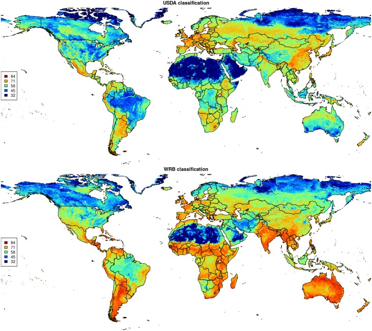
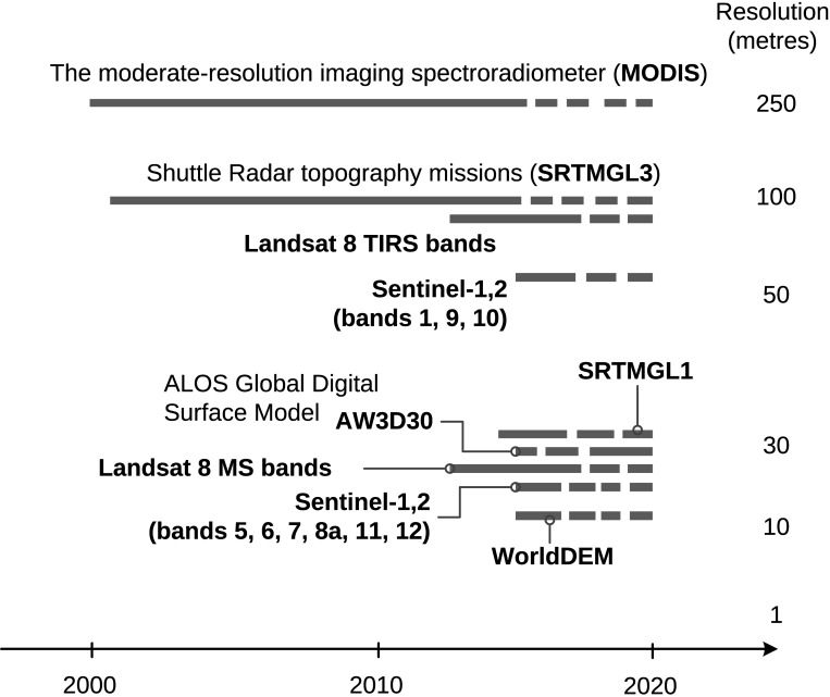
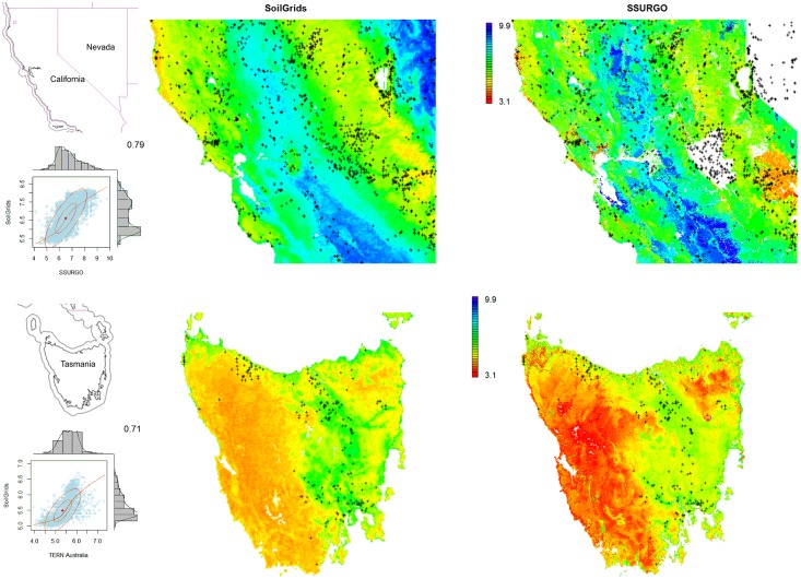
This paper describes the technical development and accuracy assessment of the most recent and improved version of the SoilGrids system at 250m resolution (June 2016 update). SoilGrids provides global predictions for standard numeric soil properties (organic carbon, bulk density, Cation Exchange Capacity (CEC), pH, soil texture fractions and coarse fragments) at seven standard depths (0, 5, 15, 30, 60, 100 and 200 cm), in addition to predictions of depth to bedrock and distribution of soil classes based on the World Reference Base (WRB) and USDA classification systems (ca. 280 raster layers in total). Predictions were based on ca. 150,000 soil profiles used for training and a stack of 158 remote sensing-based soil covariates (primarily derived from MODIS land products, SRTM DEM derivatives, climatic images and global landform and lithology maps), which were used to fit an ensemble of machine learning methods-random forest and gradient boosting and/or multinomial logistic regression-as implemented in the R packages ranger, xgboost, nnet and caret. The results of 10-fold cross-validation show that the ensemble models explain between 56% (coarse fragments) and 83% (pH) of variation with an overall average of 61%. Improvements in the relative accuracy considering the amount of variation explained, in comparison to the previous version of SoilGrids at 1 km spatial resolution, range from 60 to 230%. Improvements can be attributed to: (1) the use of machine learning instead of linear regression, (2) to considerable investments in preparing finer resolution covariate layers and (3) to insertion of additional soil profiles. Further development of SoilGrids could include refinement of methods to incorporate input uncertainties and derivation of posterior probability distributions (per pixel), and further automation of spatial modeling so that soil maps can be generated for potentially hundreds of soil variables. Another area of future research is the development of methods for multiscale merging of SoilGrids predictions with local and/or national gridded soil products (e.g. up to 50 m spatial resolution) so that increasingly more accurate, complete and consistent global soil information can be produced. SoilGrids are available under the Open Data Base License.
Overview
The claims and statistics of this paper haven’t been checked yet.
Free: it reads the open-access text and checks the first 5 claims that cite a source we can check. Create a free account to check every claim.
Integrity signals
Registry
Cites
Statistics
Figures






Verification
Claims the paper makes
The claims and statistics of this paper haven’t been checked yet.
Free: it reads the open-access text and checks the first 5 claims that cite a source we can check. Create a free account to check every claim.
Claims other papers make about this one
Each is checked against this paper’s own text: does it say what the citing paper says it does?
The source backs part of the claim, not all of it — or backs it for a different population, condition or comparison.
In the citing paper
“These uncertainties are mostly due to the uneven distribution and overall scarcity of field data for modelling and validating carbon stocks in the biomass and soil 27,64,65 .”
From Global priority areas for ecosystem restoration (2020) · cites this paper as [65]
Experimental — accuracy not yet measured
Self-check
Percentages, sums and reported differences re-computed from the paper’s own numbers.
The self-check needs the paper’s full text.
Citations
Cites
XGBoost: A Scalable Tree Boosting System
Chen, T., & Guestrin, C. (2016) · Proceedings of the 22nd ACM SIGKDD International Conference on Knowledge Discovery and Data Mining · doi:10.1145/2939672.2939785 · Cited by 54,569
Modern Applied Statistics with S
Venables, W. N., & Ripley, B. D. (2002) · Statistics and Computing · doi:10.1007/978-0-387-21706-2 · Cited by 24,305
Very high resolution interpolated climate surfaces for global land areas
Hijmans, R. J., Cameron, S. E., Parra, J. L., Jones, P. G., & Jarvis, A. (2005) · International Journal of Climatology · doi:10.1002/joc.1276 · Cited by 19,825
Total Carbon, Organic Carbon, and Organic Matter
Nelson, D. W., & Sommers, L. E. (1982) · Agronomy Monographs · doi:10.2134/agronmonogr9.2.2ed.c29 · Cited by 9,978
Building Predictive Models in R Using the caret Package
Kuhn, M. (2008) · Journal of Statistical Software · doi:10.18637/jss.v028.i05 · Cited by 8,863
Weighted kappa: nominal scale agreement provision for scaled disagreement or partial credit
Cohen, J. (1968) · Psychological Bulletin · doi:10.1037/h0026256 · Cited by 8,736
Kuhn, M., & Johnson, K. (2013) · doi:10.1007/978-1-4614-6849-3 · Cited by 6,788
Communication in the presence of noise
Shannon, C. E. (1949) · Proceedings of the IRE · doi:10.1109/jrproc.1949.232969 · Cited by 6,539
Anonim, A. (2010) · Cited by 4,945
Communication In The Presence Of Noise
Shannon, C. E. (1998) · Proceedings of the IEEE · doi:10.1109/jproc.1998.659497 · Cited by 4,804
Research works printed but not linked: 5
- D Arrouays, 2014, Soil carbon. vol. 125 of Advances in Agronomy, 93
- SA Lei, 1998, Soil Properties of the Kelso Sand Dunes in the Mojave Desert, The Southwestern Naturalist, 43, 47
- Huffman GJ, Bolvin DT. GPCP version 2 combined precipitation data set documentation. vol. 1. Laboratory for Atmospheres, NASA Goddard Space Flight Center and Science Systems and Applications; 2009.
- Kempen B. Updating soil information with digital soil mapping [PhD thesis]. Wageningen University. Wageningen; 2011. Available from: http://edepot.wur.nl/187198.
- Eberhardt E. Deriving WRB soil types using National German Soil Survey Guidelines. In: NCSS National Conference. NCSS Standards. Asheville, NC: United States Department of Agriculture USDA-NRCS; 2011. p. 1–2.
Cited by
Items 901–1,000 of 1,006
Soils in warmer and less developed countries have less micronutrients globally
Moreno‐Jiménez, E., Maestre, F. T., Flagmeier, M., Guirado, E., Berdugo, M., Bastida, F., Dacal, M., Díaz‐Martínez, P., Ochoa‐Hueso, R., Plaza, C., et al. (2022) · Global Change Biology · doi:10.1111/gcb.16478 · Cited by 47
Digital soil science and beyond
Wadoux, A. M. J. ‐., & McBratney, A. B. (2021) · Soil Science Society of America Journal · doi:10.1002/saj2.20296 · Cited by 45
Gebremicael, T. G., Deitch, M. J., Gancel, H. N., Croteau, A. C., Haile, G. G., Beyene, A. N., & Kumar, L. (2021) · Atmospheric Research · doi:10.1016/j.atmosres.2021.105939 · Cited by 42
He, Y. L., Ding, J., Dorji, T., Wang, T., Li, J., & Smith, P. (2022) · Global Change Biology · doi:10.1111/gcb.16286 · Cited by 45
Mapping soil erodibility over India
Raj, R., Saharia, M., & Chakma, S. (2023) · CATENA · doi:10.1016/j.catena.2023.107271 · Cited by 42
Quantitative Evaluation of Soil Water and Wind Erosion Rates in Pakistan
Yang, X., Yang, Q., Zhu, H., Wang, L., Wang, C., Pang, G., Du, C., Mubeen, M., Waleed, M., & Hussain, S. (2023) · Remote Sensing · doi:10.3390/rs15092404 · Cited by 42
Global patterns and environmental drivers of forest functional composition
Bouchard, É., Searle, E. B., Drapeau, P., Liang, J., Gamarra, J. G. P., Abegg, M., Alberti, G., Zambrano, A. M. A., Álvarez‐Dávila, E., Alves, L. F., et al. (2023) · Global Ecology and Biogeography · doi:10.1111/geb.13790 · Cited by 47
“We compiled seven soil variables from the SoilGrids database for a depth of 0 to 30 cm at a resolution of 250 m (Hengl et al., 2017).”
MethodForest aboveground biomass estimation by GEDI and multi-source EO data fusion over Indian forest
Mohite, J. D., Sawant, S. A., Pandit, A., Sakkan, M., Pappula, S., & Parmar, A. (2024) · International Journal of Remote Sensing · doi:10.1080/01431161.2024.2307944 · Cited by 44
“The SoilGrids is a system for global digital soil mapping that employs advanced machine learning techniques to predict and map soil property distributions worldwide (Hengl et al. 2017; Poggio et al. 2021).”
BackgroundZheng, Y., Coxon, G., Woods, R. A., Power, D., Rico‐Ramirez, M. A., McJannet, D., Rosolem, R., Li, J., & Feng, P. (2024) · Hydrology and earth system sciences · doi:10.5194/hess-28-1999-2024 · Cited by 44
Jin, C., Jian, J., Bourque, C. P. ‐., Zha, T., Dai, L., Yang, Y., Fu, R., Chen, Q., Liu, P., Li, X., et al. (2024) · CATENA · doi:10.1016/j.catena.2024.108118 · Cited by 45
Kearney, M., & Maino, J. L. (2018) · Journal of Hydrology · doi:10.1016/j.jhydrol.2018.04.040 · Cited by 44
Laborczi, A., Szatmári, G., Kaposi, A. D., & Pásztor, L. (2018) · Geoderma · doi:10.1016/j.geoderma.2018.01.020 · Cited by 44
Chemura, A., Yalew, A. W., & Gornott, C. (2021) · Frontiers in Agronomy · doi:10.3389/fagro.2021.609536 · Cited by 47
“Soil Data For soil profiles, we used the International Soil Reference and Information Center’s (ISRIC) gridded soil data (Han et al., 2015; Hengl et al., 2017).”
MethodJanssen, T., van der Velde, Y., Hofhansl, F., Luyssaert, S., Naudts, K., Driessen, B., Fleischer, K., & Dolman, A. J. (2021) · Biogeosciences · doi:10.5194/bg-18-4445-2021 · Cited by 53
Liu, D., Lei, X., Gao, W., Guo, H. M., Xie, Y., Fu, L., Lei, Y., Li, Y., Zhang, Z., & Tang, S. (2022) · Journal of Forestry Research · doi:10.1007/s11676-022-01459-4 · Cited by 45
Dangal, S. R. S., Schwalm, C. R., Cavigelli, M. A., Gollany, H. T., Jin, V. L., & Sanderman, J. (2022) · Journal of Advances in Modeling Earth Systems · doi:10.1029/2021ms002622 · Cited by 51
“Additionally, we compared simulated total SOC against two other SOC maps for the contemporary period (Hengl et al., 2017; Ramcharan et al., 2018).”
MethodZhan, C., Orth, R., Migliavacca, M., Zaehle, S., Reichstein, M., Engel, J., Rammig, A., & Winkler, A. J. (2022) · Global Change Biology · doi:10.1111/gcb.16397 · Cited by 47
“The texture data are taken from the nearest grid cell of SoilGrids dataset (Hengl et al., 2017).”
MethodNegi, H. S., Kumar, A., Rao, N. N., Thakur, N. K., Shekhar, M. S., & Snehmani (2019) · Journal of Earth System Science · doi:10.1007/s12040-019-1277-4 · Cited by 41
Maharjan, S. K., Sterck, F. J., Raes, N., & Poorter, L. (2021) · Journal of Tropical Ecology · doi:10.1017/s026646742100050x · Cited by 47
“As topsoil conditions determine whether a seedling can establish or not, the first four SoilGrids layers were used to compute the weighted average over a depth interval of 0 – 30 cm, that is topsoil, using trapezoidal rule for numerical integration (Hengl et al. 2017).”
Yu, P., Zhou, T., Luo, H., Liu, X., Shi, P., Zhang, Y., Zhang, J., Zhou, P., & Xu, Y. (2022) · Earth s Future · doi:10.1029/2022ef002703 · Cited by 44
“SOC is from the SoilGrids250 m data set (Hengl et al., 2017).”
MethodHorizontal and vertical variation of soil clay content and its controlling factors in China
Zhang, X., Zhang, W., Wu, W., & Liu, H. (2022) · The Science of The Total Environment · doi:10.1016/j.scitotenv.2022.161141 · Cited by 44
Satellites reveal Earth's seasonally shifting dust emission sources
Chappell, A., Webb, N. P., Hennen, M., Schepanski, K., Ciais, P., Balkanski, Y. J., Zender, C. S., Tegen, I., Zeng, Z., Tong, D., et al. (2023) · The Science of The Total Environment · doi:10.1016/j.scitotenv.2023.163452 · Cited by 41
“That new mean F cal is an order of magnitude smaller than the smallest dust cycle model estimates 2C) (Hengl et al., 2017).”
BackgroundMethodInfluentialSilva, . V., van Heerwaarden, J., Reidsma, P., Laborte, A. G., Tesfaye, K., & van Ittersum, M. K. (2023) · Field Crops Research · doi:10.1016/j.fcr.2023.109063 · Cited by 45
“, 2013), and inaccuracies in secondary data (Hengl et al., 2017) are known problems of on-farm production data, particularly in low-income countries.”
BackgroundThierfelder, C., Mhlanga, B., Nyagumbo, I., Kalala, K., Simutowe, E., Chiduwa, M. S., MacLaren, C., Silva, . V., & Ngoma, H. (2023) · Agriculture Ecosystems & Environment · doi:10.1016/j.agee.2023.108819 · Cited by 45
Manu, R., Iddris, N. A.-A., Corre, M. D., Aleeje, A., Mwanjalolo, M. J. G., van Straaten, O., & Veldkamp, E. (2024) · Nature Geoscience · doi:10.1038/s41561-024-01448-8 · Cited by 44
Kakhani, N., Rangzan, M., Jamali, A., Attarchi, S., Alavipanah, S. K., Mommert, M., Tziolas, N. V., & Scholten, T. (2024) · IEEE Transactions on Geoscience and Remote Sensing · doi:10.1109/tgrs.2024.3446042 · Cited by 52
“SOC prediction using DSM is an example of a regression problem that can be effectively addressed by an ML approach as proven by previous studies like [11] and [12].”
MethodDeep soil contributions to global nitrogen budgets
Almaraz, M., Wang, C., & Wong, M. Y. (2025) · Nature Communications · doi:10.1038/s41467-025-56132-1 · Cited by 48
Global variation in vegetation carbon use efficiency inferred from eddy covariance observations
Luo, X., Zhao, R., Chu, H., Collalti, A., Fatichi, S., Keenan, T. F., Lu, X., Nguyen, N., Prentice, I. C., Sun, W., et al. (2025) · Nature Ecology & Evolution · doi:10.1038/s41559-025-02753-0 · Cited by 51
Alabi, T., Adebola, P. O., Asfaw, A., Koeyer, D. L. D., Lopez‐Montes, A., & Asiedu, R. (2018) · International Journal of Applied Geospatial Research · doi:10.4018/ijagr.2019070104 · Cited by 47
“These layers were generated using an automated mapping framework based on random forests (Hengl et al., 2017).”
MethodCognitive Biases about Climate Variability in Smallholder Farming Systems in Zambia
Waldman, K. B., Vergopolan, N., Attari, S. Z., Sheffield, J., Estes, L. D., Caylor, K. K., & Evans, T. P. (2019) · Weather Climate and Society · doi:10.1175/wcas-d-18-0050.1 · Cited by 41
Csilléry, K., Ovaskainen, O., Sperisen, C., Buchmann, N., Widmer, A., & Gugerli, F. (2019) · Heredity · doi:10.1038/s41437-019-0240-0 · Cited by 41
Serna, A., Prates, L., Mange, E., Salazar‐García, D. C., & Bataille, C. P. (2020) · Journal of Archaeological Science · doi:10.1016/j.jas.2020.105198 · Cited by 46
Janzen, A., Bataille, C. P., Copeland, S. R., Quinn, R. L., Ambrose, S. H., Reed, D. N., Hamilton, M. I., Grimes, V., Richards, M. P., le Roux, P., et al. (2020) · Palaeogeography Palaeoclimatology Palaeoecology · doi:10.1016/j.palaeo.2020.109957 · Cited by 49
Trigoso, D. I., López, R. S., Briceño, N. B. R., Silva-López, J. O., Gómez-Fernández, D., Oliva, M., Huatangari, L. Q., Murga, R. E. T., Barboza, E., & Gurbillón, M. Á. B. (2020) · Agronomy · doi:10.3390/agronomy10121898 · Cited by 49
“Therefore, the silt layer was calculated by supplementing the Sand + Clay layer to 100, and N and SOM layers were obtained from SoilGrids.”
BackgroundMethodInfluentialPost‐glacial determinants of regional species pools in alpine grasslands
Jiménez‐Alfaro, B., Abdulhak, S., Attorre, F., Bergamini, A., Carranza, M. L., Chiarucci, A., Ćušterevska, R., Dullinger, S., Gavilán, R. G., del Galdo, G. G., et al. (2021) · Global Ecology and Biogeography · doi:10.1111/geb.13274 · Cited by 43
Addressing hydrological modeling in watersheds under land cover change with deep learning
Althoff, D., Rodrigues, L. N., & da Silva, D. D. (2021) · Advances in Water Resources · doi:10.1016/j.advwatres.2021.103965 · Cited by 44
Radočaj, D., Jurišić, M., Gašparović, M., Plašćak, I., & Antonić, O. (2021) · Agronomy · doi:10.3390/agronomy11081620 · Cited by 41
“250 SoilGrids [50] Soil organic carbon dg kg−1 pH / Cation exchange capacity mmol(c) kg−1 Clay content g kg−1 Silt content g kg−1 Sand content g kg−1 Bulk density cg cm−3”
BackgroundMethodInfluentialIdentifying opportunities to improve digital soil mapping in India: A systematic review
Dash, P. K., Panigrahi, N., & Mishra, A. (2021) · Geoderma Regional · doi:10.1016/j.geodrs.2021.e00478 · Cited by 44
Chang, C.-W., Fridman, E., Mascher, M., Himmelbach, A., & Schmid, K. (2022) · Heredity · doi:10.1038/s41437-021-00494-x · Cited by 45
“…data from the WorldClim2 database (Fick and Hijmans 2017) with a resolution of 30 arcseconds [~1 km], (2) soil data from the SoilGrids database (Hengl et al. 2017) with a resolution of 250m, (3) topographic variables based on elevation data from the SRTM database (https://srtm.csi.cgiar.org/)…”
MethodOlivera-Guerra, L., Laluet, P., Altés, V., Ollivier, C., Pageot, Y., Paolini, G., Chavanon, E., Rivalland, V., Boulet, G., Mir, J. M. V., et al. (2022) · Agricultural Water Management · doi:10.1016/j.agwat.2022.108119 · Cited by 44
Estimating Lime Requirements for Tropical Soils: Model Comparison and Development
Aramburu-Merlos, F., Silva, . V., Baudron, F., & Hijmans, R. J. (2022) · Geoderma · doi:10.1016/j.geoderma.2023.116421 · Cited by 40
“In these circumstances, models to estimate lime requirements from generally available soil property data (Hengl et al., 2017; Miller et al., 2021) could help better understand the potential benefits of liming.”
BackgroundBiogenic factors explain soil carbon in paired urban and natural ecosystems worldwide
Delgado‐Baquerizo, M., García‐Palacios, P., Bradford, M. A., Eldridge, D. J., Berdugo, M., Sáez‐Sandino, T., Liu, Y., Alfaro, F. D., Abades, S. R., Bamigboye, A. R., et al. (2023) · Nature Climate Change · doi:10.1038/s41558-023-01646-z · Cited by 45
Exploring the inter-decadal variability of soil organic carbon in China
Zhang, Z., Ding, J., Zhu, C., Wang, J., Li, X., Ge, X., Han, L., Chen, X., & Wang, J. (2023) · CATENA · doi:10.1016/j.catena.2023.107242 · Cited by 40
Howard, J. K., Dooley, K. E., Brauman, K. A., Klausmeyer, K. R., & Rohde, M. M. (2023) · Frontiers in Water · doi:10.3389/frwa.2023.1115416 · Cited by 42
“Soil carbon stocks were calculated using depth ranges in soil grids (Hengl et al., 2017).”
MethodImproving digital mapping of soil organic matter in cropland by incorporating crop rotation
Liu, Y., Chen, S., Yu, Q., Cai, Z., Zhou, Q., Bellingrath‐Kimura, S. D., & Wu, W. (2023) · Geoderma · doi:10.1016/j.geoderma.2023.116620 · Cited by 45
Soil moisture at 30 m from multiple satellite datasets fused by random forest
Ning, J., Yao, Y., Tang, Q., Li, Y., Fisher, J. B., Zhang, X., Jia, K., Xu, J., Shang, K., Yang, J., et al. (2023) · Journal of Hydrology · doi:10.1016/j.jhydrol.2023.130010 · Cited by 42
Yang, Y., Zhong, M., Bian, X., You, Y., & Li, F. (2023) · Biochar · doi:10.1007/s42773-023-00260-8 · Cited by 40
“Globally, the area covered by sandy soils reached 4.99 × 10 7 km 2 , accounting for 31% of the global total land area (Hengl et al. 2017).”
BackgroundInfluentialPeng, Z., Zhao, T., Shi, J., Hu, L., Rodríguez-Fernández, N. J., Wigneron, J., Jackson, T. J., Walker, J. P., Cosh, M. H., Yang, K., et al. (2023) · Remote Sensing of Environment · doi:10.1016/j.rse.2023.113970 · Cited by 40
On the challenges of global entity-aware deep learning models for groundwater level prediction
Heudorfer, B., Liesch, T., & Broda, S. (2024) · Hydrology and earth system sciences · doi:10.5194/hess-28-525-2024 · Cited by 47
“BGR (2018) Clay Clay content of the soil in weight fraction % Hengl et al. (2017) Sand Sand content of the soil in weight fraction % Hengl et al. (2017)”
Global, spatially explicit modelling of zenith wet delay with XGBoost
Crocetti, L., Schartner, M., Zus, F., Zhang, W., Möller, G., Navarro, V., See, L., Schindler, K., & Soja, B. S. (2024) · Journal of Geodesy · doi:10.1007/s00190-024-01829-2 · Cited by 46
“Based on that investigation, the XGBoost method was found to be the most promising candidate, in line with many other ML tasks based on relatively low-dimensional feature sets (Yan et al. 2020; Lundberg et al. 2018; Hengl et al. 2017; Xia et al. 2017; Zi¸eba et al. 2016).”
von Fromm, S. F., Hoyt, A. M., Sierra, C. A., Georgiou, K., Döetterl, S., & Trumbore, S. E. (2024) · Global Change Biology · doi:10.1111/gcb.17320 · Cited by 46
“…zones (Beck et al., 2018 ), mean annual precipitation (MAP; mm) and mean annual temperature (MAT;°C; WorldClim v2; Fick & Hijmans, 2017 ), potential evapotranspiration (PET; mm; Zomer et al., 2022 ), clay content (%; SoilGrids v1; Hengl et al., 2017 ), and soil order (USDA; Shi et al., 2020 ).”
BackgroundOpen Remote Sensing Data in Digital Soil Organic Carbon Mapping: A Review
Radočaj, D., Gašparović, M., & Jurišić, M. (2024) · Agriculture · doi:10.3390/agriculture14071005 · Cited by 47
Global Wind Erosion Reduction Driven by Changing Climate and Land Use
Sun, R., He, H., Jing, Y., Leng, S., Yang, G., Lü, Y., Pasquale, B., Chen, L., & Fu, B. (2024) · Earth s Future · doi:10.1029/2024ef004930 · Cited by 45
A Blockchain-Assisted Trusted Federated Learning for Smart Agriculture
Manoj, T., Makkithaya, K., & Narendra, V. G. (2025) · SN Computer Science · doi:10.1007/s42979-025-03672-4 · Cited by 57
“This results in 66 soil features (11 features × 6 depths), obtained from the SoilGrids250m database [64].”
The Significance of the Spatial Variability of Rainfall on the Numerical Simulation of Urban Floods
Courty, L. G., Rico‐Ramirez, M. A., & Pedrozo‐Acuña, A. (2018) · Water · doi:10.3390/w10020207 · Cited by 44
Habibie, M. I., Noguchi, R., Matsushita, S., & Ahamed, T. (2020) · Remote Sensing Applications Society and Environment · doi:10.1016/j.rsase.2020.100421 · Cited by 40
Monteleone, B., Borzì, I., Bonaccorso, B., & Martina, M. L. V. (2022) · Agricultural Water Management · doi:10.1016/j.agwat.2022.107713 · Cited by 45
Xie, J., Liu, X., Tian, W., Wang, K., Bai, P., & Liu, C. (2022) · Water Resources Research · doi:10.1029/2021wr031663 · Cited by 44
Towards species‐level forecasts of drought‐induced tree mortality risk
Kauwe, M. G. D., Sabot, M. E. B., Medlyn, B. E., Pitman, A. J., Meir, P., Cernusak, L. A., Gallagher, R. V., Ukkola, A., Rifai, S. W., & Choat, B. (2022) · New Phytologist · doi:10.1111/nph.18129 · Cited by 40
Pejak, B., Lugonja, P., Antić, A., Panić, M. N., Pandžić, M., Alexakis, E., Mavrepis, P., Zhou, N., Marko, O., & Crnojevic, V. S. (2022) · Remote Sensing · doi:10.3390/rs14092256 · Cited by 62
“Another set of inputs was the soil features retrieved via ISRIC’s (International Soil Reference and Information Centre) SoilGrids platform [67].”
MethodClimate legacies drive the distribution and future restoration potential of dryland forests
Guirado, E., Delgado‐Baquerizo, M., Martínez‐Valderrama, J., Tabik, S., Alcaraz‐Segura, D., & Maestre, F. T. (2022) · Nature Plants · doi:10.1038/s41477-022-01198-8 · Cited by 42
“…of data from Worldclim 23 and the Japanese 55-year Reanalysis (JRA55) 45 ; soil organic carbon stock, texture (sand content) and pH from Soilgrids 25 ; albedo from MODIS/ Terra MCD43A3 Version 6 at 500 m pixel resolution 46 ; elevation and slope from the Advanced Land Observation Satellite…”
InfluentialJiménez, J. C. M., Valdez‐Lazalde, J. R., Ángeles-Perez, G., Santos-Posadas, H. M. D. L., & Cruz-Cárdenas, G. (2022) · iForest - Biogeosciences and Forestry · doi:10.3832/ifor4084-015 · Cited by 44
Chomba, I. C., Banda, K. E., Winsemius, H., Eunice, M., Sichingabula, H. M., & Nyambe, I. A. (2022) · Journal of Human Earth and Future · doi:10.28991/hef-2022-03-02-09 · Cited by 40
“Globcover for landcover [28], SoilGrids [29] for soil parameters, we used MERIT Hydro; MERIT DEM for catchment delineation as well as Lake Hydro for lake data acquisition [30].”
MethodMOULATLET, G. M., Zuquim, G., Figueiredo, F. O. G., Lehtonen, S., Emilio, T., Ruokolainen, K., & Tuomisto, H. (2017) · Ecology and Evolution · doi:10.1002/ece3.3242 · Cited by 49
“In the newer version of SoilGrids at 250- m resolution (which was used in our analyses), the displacement of the floodplains has been corrected with the help of the SRTM digital elevation model (Hengl et al., 2017).”
BackgroundMethodInfluentialGlobal variability in belowground autotrophic respiration in terrestrial ecosystems
Tang, X., Fan, S., Zhang, W., Gao, S., Chen, G., & Shi, L. (2019) · Earth system science data · doi:10.5194/essd-11-1839-2019 · Cited by 45
Cotton Yield Estimate Using Sentinel-2 Data and an Ecosystem Model over the Southern US
He, L., & Mostovoy, G. V. (2019) · Remote Sensing · doi:10.3390/rs11172000 · Cited by 39
Integrating Agriculture and Ecosystems to Find Suitable Adaptations to Climate Change
Thayer, A. W., Vargas, A. M., Castellanos, A. A., Lafon, C. W., McCarl, B. A., Roelke, D. L., Winemiller, K. O., & Lacher, T. E. (2020) · Climate · doi:10.3390/cli8010010 · Cited by 51
Patterns and environmental controls of soil organic carbon density in Chinese shrublands
Ge, J., Xu, W., Liu, Q., Tang, Z., & Xie, Z. (2020) · Geoderma · doi:10.1016/j.geoderma.2019.114161 · Cited by 39
Humphreys, J. M., Ramey, A. M., Douglas, D. C., Mullinax, J. M., Soos, C., Link, P. T., Walther, P., & Prosser, D. J. (2020) · Scientific Reports · doi:10.1038/s41598-020-59077-1 · Cited by 44
Scaling Up Agricultural Research With Artificial Intelligence
Bestelmeyer, B. T., Marcillo, G. S., McCord, S. E., Mirsky, S. B., Moglen, G. E., Neven, L. G., Peters, D. P. C., Djebou, D. C. S., & Wakie, T. (2020) · IT Professional · doi:10.1109/mitp.2020.2986062 · Cited by 39
“A global product, SoilGrids, provides estimates of nine soil properties at standard depths at a 250-m resolution.(3) These products also represent the uncertainty of soil predictions.”
BackgroundKougioumoutzis, K., Kokkoris, I., Panitsa, M., Trigas, P., Strid, A., & Dimopoulos, P. (2020) · Biology · doi:10.3390/biology9080199 · Cited by 42
“Seven soil variables providing predicted values for the surface soil layer at varying depths, were obtained from the SoilGrids database [71].”
MethodSpectral signatures of soil horizons and soil orders – An exploratory study of 270 soil profiles
Zhang, Y., Hartemink, A. E., & Huang, J. (2021) · Geoderma · doi:10.1016/j.geoderma.2021.114961 · Cited by 41
McNellis, B. E., Smith, A. M. S., Hudak, A. T., & Strand, E. K. (2021) · Ecosphere · doi:10.1002/ecs2.3419 · Cited by 45
“Soil variables were taken from 250-m resolution SoilGrids maps and weighted pro fi le averages from 0 to 30 cm depth (Hengl et al. 2017).”
Machine learning techniques for acid sulfate soil mapping in southeastern Finland
Estévez, V., Beucher, A., Mattbäck, S., Boman, A., Auri, J., Björk, K.-M., & Österholm, P. (2021) · Geoderma · doi:10.1016/j.geoderma.2021.115446 · Cited by 46
Parameter uncertainty dominates C-cycle forecast errors over most of Brazil for the 21st century
Smallman, T. L., Milodowski, D. T., Neto, E. S., Koren, G., Ometto, J. P., & Williams, M. (2021) · Earth System Dynamics · doi:10.5194/esd-12-1191-2021 · Cited by 43
Najmuddin, O., Deng, X., & Bhattacharya, R. (2018) · Sustainability · doi:10.3390/su10020423 · Cited by 43
“The overall validation accuracy of the used models for soil properties mapping is 61% [44].”
MethodModelling Forest Ecosystems: a crossroad between scales, techniques and applications
Blanco, J. A., Améztegui, A., & Rodríguez, F. (2020) · Ecological Modelling · doi:10.1016/j.ecolmodel.2020.109030 · Cited by 39
“situation has significantly improved with the release of the SoilGrids250m database (Hengl et al. 2017).”
BackgroundA geospatial mapping pipeline for ecologistsPreprint
van den Hoogen, J., Robmann, N. M., Routh, D., Lauber, T. B., van Tiel, N., Danylo, O., & Crowther, T. W. (2021) · bioRxiv (Cold Spring Harbor Laboratory) · doi:10.1101/2021.07.07.451145 · Cited by 49
Campbell, P., Tang, Y., Lee, P., Baker, B., Tong, D., Saylor, R., Stein, A., Huang, J., Huang, H., Strobach, E., et al. (2022) · Geoscientific model development · doi:10.5194/gmd-15-3281-2022 · Cited by 45
Global and regional soil organic carbon estimates: Magnitudes and uncertainties
Lin, Z., Dai, Y., Mishra, U., Wang, G., Shangguan, W., Zhang, W., & Qin, Z. (2023) · Pedosphere · doi:10.1016/j.pedsph.2023.06.005 · Cited by 44
Self-citationLilburne, L., Helfenstein, A., Heuvelink, G. B. M., & Eger, A. (2024) · Geoderma · doi:10.1016/j.geoderma.2024.117052 · Cited by 43
Self-citationMeng, X., Bao, Y., Zhang, X., Luo, C., & Liu, H. (2024) · Remote Sensing of Environment · doi:10.1016/j.rse.2024.114592 · Cited by 42
Norouzi, S., Pesch, C., Arthur, E., Nørgaard, T., Møldrup, P., Greve, M. H., Beucher, A., Sadeghi, M., Zaresourmanabad, M., Tuller, M., et al. (2025) · Water Resources Research · doi:10.1029/2024wr038149 · Cited by 38
“Incorporating additional environmental covariates offers potential for improving the model's predictions, especially in digital soil mapping (Gupta et al., 2021; Hengl et al., 2017).”
Schürz, C., Hollósi, B., Matulla, C., Pressl, A., Ertl, T., Schulz, K., & Mehdi, B. (2019) · Hydrology and earth system sciences · doi:10.5194/hess-23-1211-2019 · Cited by 40
“The SoilGrids database (Hengl et al., 2017) is a consistent global soil information system that provides soil physical and chemical parameters at a 250 m grid resolution and seven soil depths.”
MethodUncertainties and policy challenges in implementing Land Degradation Neutrality in Russia
Kust, G. S., Andreeva, O., Lobkovskiy, V., & Telnova, N. (2018) · Environmental Science & Policy · doi:10.1016/j.envsci.2018.08.010 · Cited by 48
Kanda, T., Takata, Y., Kohyama, K., Ohkura, T., Maejima, Y., Wakabayashi, S., & Obara, H. (2018) · Japan Agricultural Research Quarterly JARQ · doi:10.6090/jarq.52.285 · Cited by 38
“Following the preparation of the Hokkaido map, Kanda et al. (2016b) created a similar CSCJ soil map for the Hokuriku and Chubu regions.”
BackgroundMethodInfluentialFit-for-purpose modelling of radiocaesium soil-to-plant transfer for nuclear emergencies: a review
Almahayni, T., Beresford, N. A., Crout, N. M. J., & Sweeck, L. (2019) · Journal of Environmental Radioactivity · doi:10.1016/j.jenvrad.2019.01.006 · Cited by 38
Xie, X., Li, A., Tan, J., Jin, H., Nan, X., Zhang, Z., Bian, J., & Lei, G. (2019) · Agricultural and Forest Meteorology · doi:10.1016/j.agrformet.2019.107771 · Cited by 38
Response to Comments on “The global tree restoration potential”
Bastin, J., Finegold, Y., García, C., Gellie, N., Lowe, A. J., Mollicone, D., Rezende, M., Routh, D., Sacandé, M., Sparrow, B. D., et al. (2019) · Science · doi:10.1126/science.aay8108 · Cited by 39
“We estimated the amount of carbon currently held in vegetation using the IPCC global biomass map (18) and the carbon held in soil using the soilgrid layers (19).”
MethodBiogeographic historical legacies in the net primary productivity of Northern Hemisphere forests
Conradi, T., Meerbeek, K. V., Ordóñez, A., & Svenning, J. (2020) · Ecology Letters · doi:10.1111/ele.13481 · Cited by 40
Holzmeyer, L., Hartig, A.-K., Franke, K., Brandt, W., Muellner-Riehl, A. N., Wessjohann, L. A., & Schnitzler, J. (2020) · Proceedings of the National Academy of Sciences · doi:10.1073/pnas.1915277117 · Cited by 39
Pang, S. E. H., Alban, J. D. T. D., & Webb, E. L. (2021) · Scientific Reports · doi:10.1038/s41598-020-79491-9 · Cited by 42
Joshi, J. R. (2021) · Atmospheric Environment · doi:10.1016/j.atmosenv.2021.118658 · Cited by 39
Rusli, S. R., Weerts, A. H., Taufiq, A., & Bense, V. F. (2021) · Journal of Hydrology: Regional Studies · doi:10.1016/j.ejrh.2021.100911 · Cited by 17
Qiu, T., Sharma, S., Woodall, C. W., & Clark, J. S. (2021) · Frontiers in Ecology and Evolution · doi:10.3389/fevo.2021.719141 · Cited by 44
Chen, Z., Wei, X., Ni, X., Wu, F., & Liao, S. (2022) · Geoderma · doi:10.1016/j.geoderma.2022.116279 · Cited by 41
Almamari, M., Kantoush, S. A., Alharrasi, T., Al-Maktoumi, A. K., Abdrabo, K. I., Saber, M., & Sumi, T. (2022) · Journal of Hydrology · doi:10.1016/j.jhydrol.2022.128982 · Cited by 37
Constructing soils for climate-smart mining
Ruíz, F., Safanelli, J. L., Perlatti, F., Cherubin, M. R., Demattê, J. A. M., Cerri, C. E. P., Otero, X. L., Rumpel, C., & Ferreira, T. O. (2023) · Communications Earth & Environment · doi:10.1038/s43247-023-00862-x · Cited by 37
Global predictions of topsoil organic carbon stocks under changing climate in the 21st century
Chen, B., Lu, Q., Wei, L., Fu, W., Wei, Z., & Tian, S. (2023) · The Science of The Total Environment · doi:10.1016/j.scitotenv.2023.168448 · Cited by 37
Benà, E., Ciotoli, G., Petermann, E., Bossew, P., Ruggiero, L., Verdi, L., Huber, P., Mori, F., Mazzoli, C., & Sassi, R. (2023) · The Science of The Total Environment · doi:10.1016/j.scitotenv.2023.169569 · Cited by 39
Metadata
- Authors
- Hengl, T., Mendes de Jesus, J., Heuvelink, G. B. M., Ruiperez Gonzalez, M., Kilibarda, M., Blagotić, A., Shangguan, W., Wright, M. N., Geng, X., Bauer-Marschallinger, B., Guevara, M. A., Vargas, R., MacMillan, R. A., Batjes, N. H., Leenaars, J. G. B., Ribeiro, E., Wheeler, I., Mantel, S., & Kempen, B.
- Affiliations
- ISRIC - World Soil Information (NL)
- University of Belgrade (RS)
- Sun Yat-sen University (CN)
- University of Lübeck (DE)
- Agriculture and Agri-Food Canada (CA)
- TU Wien (AT)
- University of Delaware (US)
- ORCID
- Venue
- PLOS ONE
- Publisher
- Public Library of Science (PLoS)
- Published
- 2017-02-16
- Volume
- 12
- Issue
- 2
- Pages
- e0169748
- ISSN
- 1932-6203 (ISSN-L)
- PMC
- PMC5313206
- OpenAlex
- W2588003345
- Cited by
- 4,733
- References
- 89
- Citations by year
- 2026: 591 · 2025: 654 · 2024: 610 · 2023: 634 · 2022: 669 · 2021: 672 · 2020: 402 · 2019: 265 · 2018: 173 · 2017: 56
- FWCI
- 137.14
- Type
- journal article
- Language
- en
- Open access
- gold
- doi.org
- Licence
- Locations
- PLoS ONE (publishedVersion, cc-by)
- PubMed Central (publishedVersion, cc-by)
- PubMed (publishedVersion)
- RePEc: Research Papers in Economics (submittedVersion)
- DOAJ (DOAJ: Directory of Open Access Journals) (submittedVersion)
- GraFar (University of Belgrade, Faculty of Civil Engineering) (submittedVersion, cc-by)
- Socio-Environmental Systems Modeling (submittedVersion, cc-by)
- Data Archiving and Networked Services (DANS) (submittedVersion, other-oa)
- Topics
- Life Sciences › Agricultural and Biological Sciences › Soil Science › Soil Geostatistics and Mapping
- Physical Sciences › Environmental Science › Environmental Engineering › Soil Moisture and Remote Sensing
- Physical Sciences › Environmental Science › Management, Monitoring, Policy and Law › Soil and Land Suitability Analysis
- Keywords
- SoilGrids, soil properties, soil organic carbon, soil bulk density, cation exchange capacity, soil pH, soil texture, coarse fragments, bedrock depth, soil classification, USDA soil classification, MODIS, random forest, gradient boosting, multinomial logistic regression, ensemble learning, accuracy assessment, soil mapping
- MeSH terms
- Machine Learning, Algorithms, Conservation of Natural Resources, Environmental Monitoring, Humans, Models, Theoretical, Soil, Geographic Information Systems
About these checks
Registry, retraction, Cites and statistics results are computed, not judged, with one exception: a printed reference that no index lists is read once by a model before it counts as a citation error. Claims are extracted by a model and kept only when their quote appears verbatim in the text; each cited source is then checked, with a model’s help, for whether it says what the claim relies on. Those verdicts can be wrong — read the claim’s quote and the cited source before relying on one.
Statistics and arithmetic are recomputed, not judged.
Confidence bands are shown only for fields calibrated on our annotated test set. None is calibrated yet, so no band is shown.
What counts as a claim ›How we measure confidence ›How we check this ›
Are you an author, or do you see a problem with this page? Request a review
Data sources
Bibliographic data: Semantic Scholar, OpenAlex, Crossref.
Contains information from the Semantic Scholar Academic Graph Datasets, made available under the ODC Attribution License (ODC-BY 1.0).
Semantic Scholar’s data is described in: Kinney, R., et al. (2023). The Semantic Scholar Open Data Platform. arXiv:2301.10140.
