

SoilGrids250m: Global gridded soil information based on machine learning
Open accessThe DOI matches its Crossref record; 85 of the 89 references it cites were found in a registry or an index.
Abstract
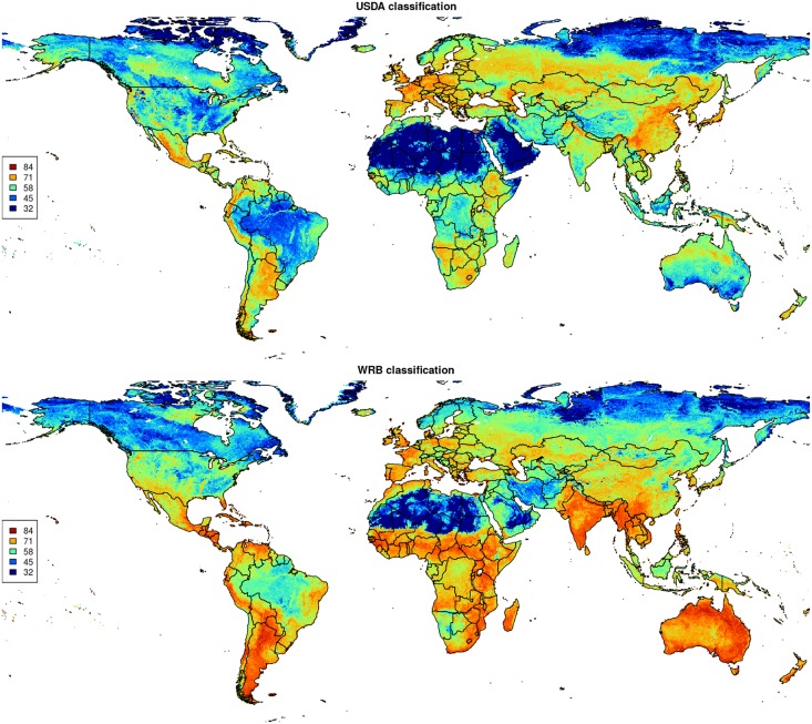
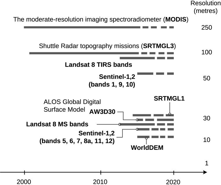
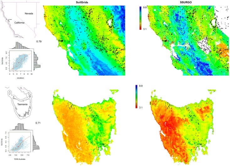
This paper describes the technical development and accuracy assessment of the most recent and improved version of the SoilGrids system at 250m resolution (June 2016 update). SoilGrids provides global predictions for standard numeric soil properties (organic carbon, bulk density, Cation Exchange Capacity (CEC), pH, soil texture fractions and coarse fragments) at seven standard depths (0, 5, 15, 30, 60, 100 and 200 cm), in addition to predictions of depth to bedrock and distribution of soil classes based on the World Reference Base (WRB) and USDA classification systems (ca. 280 raster layers in total). Predictions were based on ca. 150,000 soil profiles used for training and a stack of 158 remote sensing-based soil covariates (primarily derived from MODIS land products, SRTM DEM derivatives, climatic images and global landform and lithology maps), which were used to fit an ensemble of machine learning methods-random forest and gradient boosting and/or multinomial logistic regression-as implemented in the R packages ranger, xgboost, nnet and caret. The results of 10-fold cross-validation show that the ensemble models explain between 56% (coarse fragments) and 83% (pH) of variation with an overall average of 61%. Improvements in the relative accuracy considering the amount of variation explained, in comparison to the previous version of SoilGrids at 1 km spatial resolution, range from 60 to 230%. Improvements can be attributed to: (1) the use of machine learning instead of linear regression, (2) to considerable investments in preparing finer resolution covariate layers and (3) to insertion of additional soil profiles. Further development of SoilGrids could include refinement of methods to incorporate input uncertainties and derivation of posterior probability distributions (per pixel), and further automation of spatial modeling so that soil maps can be generated for potentially hundreds of soil variables. Another area of future research is the development of methods for multiscale merging of SoilGrids predictions with local and/or national gridded soil products (e.g. up to 50 m spatial resolution) so that increasingly more accurate, complete and consistent global soil information can be produced. SoilGrids are available under the Open Data Base License.
Overview
The claims and statistics of this paper haven’t been checked yet.
Free: it reads the open-access text and checks the first 5 claims that cite a source we can check. Create a free account to check every claim.
Integrity signals
Registry
Cites
Statistics
Figures

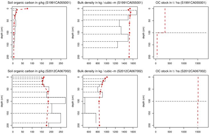
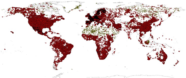
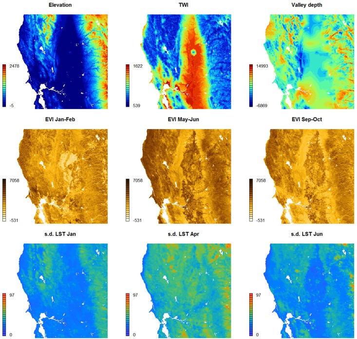


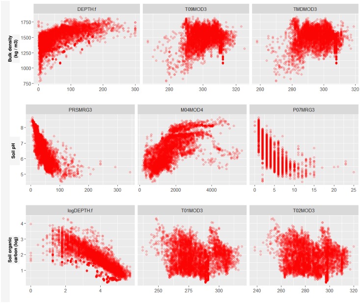



Verification
Claims the paper makes
The claims and statistics of this paper haven’t been checked yet.
Free: it reads the open-access text and checks the first 5 claims that cite a source we can check. Create a free account to check every claim.
Claims other papers make about this one
Each is checked against this paper’s own text: does it say what the citing paper says it does?
The source backs part of the claim, not all of it — or backs it for a different population, condition or comparison.
In the citing paper
“These uncertainties are mostly due to the uneven distribution and overall scarcity of field data for modelling and validating carbon stocks in the biomass and soil 27,64,65 .”
From Global priority areas for ecosystem restoration (2020) · cites this paper as [65]
Experimental — accuracy not yet measured
Self-check
Percentages, sums and reported differences re-computed from the paper’s own numbers.
The self-check needs the paper’s full text.
Citations
Cites
XGBoost: A Scalable Tree Boosting System
Chen, T., & Guestrin, C. (2016) · Proceedings of the 22nd ACM SIGKDD International Conference on Knowledge Discovery and Data Mining · doi:10.1145/2939672.2939785 · Cited by 54,569
Modern Applied Statistics with S
Venables, W. N., & Ripley, B. D. (2002) · Statistics and Computing · doi:10.1007/978-0-387-21706-2 · Cited by 24,305
Very high resolution interpolated climate surfaces for global land areas
Hijmans, R. J., Cameron, S. E., Parra, J. L., Jones, P. G., & Jarvis, A. (2005) · International Journal of Climatology · doi:10.1002/joc.1276 · Cited by 19,825
Total Carbon, Organic Carbon, and Organic Matter
Nelson, D. W., & Sommers, L. E. (1982) · Agronomy Monographs · doi:10.2134/agronmonogr9.2.2ed.c29 · Cited by 9,978
Building Predictive Models in R Using the caret Package
Kuhn, M. (2008) · Journal of Statistical Software · doi:10.18637/jss.v028.i05 · Cited by 8,863
Weighted kappa: nominal scale agreement provision for scaled disagreement or partial credit
Cohen, J. (1968) · Psychological Bulletin · doi:10.1037/h0026256 · Cited by 8,736
Kuhn, M., & Johnson, K. (2013) · doi:10.1007/978-1-4614-6849-3 · Cited by 6,788
Communication in the presence of noise
Shannon, C. E. (1949) · Proceedings of the IRE · doi:10.1109/jrproc.1949.232969 · Cited by 6,539
Anonim, A. (2010) · Cited by 4,945
Communication In The Presence Of Noise
Shannon, C. E. (1998) · Proceedings of the IEEE · doi:10.1109/jproc.1998.659497 · Cited by 4,804
Research works printed but not linked: 5
- D Arrouays, 2014, Soil carbon. vol. 125 of Advances in Agronomy, 93
- SA Lei, 1998, Soil Properties of the Kelso Sand Dunes in the Mojave Desert, The Southwestern Naturalist, 43, 47
- Huffman GJ, Bolvin DT. GPCP version 2 combined precipitation data set documentation. vol. 1. Laboratory for Atmospheres, NASA Goddard Space Flight Center and Science Systems and Applications; 2009.
- Kempen B. Updating soil information with digital soil mapping [PhD thesis]. Wageningen University. Wageningen; 2011. Available from: http://edepot.wur.nl/187198.
- Eberhardt E. Deriving WRB soil types using National German Soil Survey Guidelines. In: NCSS National Conference. NCSS Standards. Asheville, NC: United States Department of Agriculture USDA-NRCS; 2011. p. 1–2.
Cited by
Items 301–400 of 1,006
Priority areas to protect mangroves and maximise ecosystem services
Dabalà, A., Dahdouh‐Guebas, F., Dunn, D. C., Everett, J. D., Lovelock, C. E., Hanson, J. O., Buenafe, K. C. V., Neubert, S., & Richardson, A. J. (2023) · Nature Communications · doi:10.1038/s41467-023-41333-3 · Cited by 140
“…of depth, an initial estimate of the 0 – 200cm organic carbon stock from the global SoilGrids 250-m model down-sampled to 30 m resolution 88 , and a suite of spatially-explicit covariate layers (i.e., vegetation characteristics, digital elevation data, long-term mean monthly sea surface…”
BackgroundGuevara, M., Olmedo, G. F., Stell, E., Yiğini, Y., Aguilar, Y., Hernández, C. A., Arévalo, G. E., Arroyo-Cruz, C. E., Bolivar, A., Bunning, S., et al. (2018) · SOIL · doi:10.5194/soil-4-173-2018 · Cited by 134
Self-citationGibert, K., Horsburgh, J. S., Athanasiadis, I. N., & Holmes, G. (2018) · Environmental Modelling & Software · doi:10.1016/j.envsoft.2018.04.005 · Cited by 112
Mohamed, S. A., Metwaly, M. M., Metwalli, M. R., AbdelRahman, M. A. E., & Badreldin, N. (2023) · Remote Sensing · doi:10.3390/rs15071751 · Cited by 125
The global contribution of soil mosses to ecosystem services
Eldridge, D. J., Guirado, E., Reich, P. B., Ochoa‐Hueso, R., Berdugo, M., Sáez‐Sandino, T., Blanco‐Pastor, J. L., Tedersoo, L., Plaza, C., Ding, J., et al. (2023) · Nature Geoscience · doi:10.1038/s41561-023-01170-x · Cited by 138
Water management dilemma in the agricultural sector of Iran: A review focusing on water governance
Nouri, M., Homaee, M., Pereira, L. S., & Bybordi, M. (2023) · Agricultural Water Management · doi:10.1016/j.agwat.2023.108480 · Cited by 123
Liang, Z., Chen, S., Yang, Y., Zhou, Y., & Shi, Z. (2019) · The Science of The Total Environment · doi:10.1016/j.scitotenv.2019.05.332 · Cited by 116
Giuliani, G., Chatenoux, B., Benvenuti, A., Lacroix, P., Santoro, M., & Mazzetti, P. (2020) · Big Earth Data · doi:10.1080/20964471.2020.1711633 · Cited by 122
“To estimate changes in SOC, the proposed methodology by Trends.”
BackgroundMethodInfluentialEcological Niche Modeling: An Introduction for Veterinarians and Epidemiologists
Escobar, L. E. (2020) · Frontiers in Veterinary Science · doi:10.3389/fvets.2020.519059 · Cited by 123
“For example, many datasets of soil composition and structure (5), landscape composition and structure (6), and climate and geomorphology (7–9) are freely and openly available for mapping diseases in aquatic and terrestrial ecosystems globally.”
BackgroundEU-Trees4F, a dataset on the future distribution of European tree species
Mauri, A., Girardello, M., Strona, G., Beck, P. S. A., Forzieri, G., Caudullo, G., Manca, F., & Cescatti, A. (2022) · Scientific Data · doi:10.1038/s41597-022-01128-5 · Cited by 128
Modelling the water balance of Lake Victoria (East Africa) – Part 1: Observational analysis
Vanderkelen, I., van Lipzig, N. P. M., & Thiery, W. (2018) · Hydrology and earth system sciences · doi:10.5194/hess-22-5509-2018 · Cited by 114
Carbon sequestration potential of tree planting in China
Yao, L., Liu, T., Qin, J., Jiang, H., Yang, L., Smith, P., Chen, X., Zhou, C., & Piao, S. L. (2024) · Nature Communications · doi:10.1038/s41467-024-52785-6 · Cited by 135
“…51 , annual maximum land surface temperature 52 , annual minimum land surface temperature 52 , and annual snow cover index 53 ), nine soil variables 54 (bulk density, coarse fragments, organic carbon density, pH value, sand content, silt content, clay content, cation exchange capacity, and total…”
Landslide size matters: A new data-driven, spatial prototype
Lombardo, L., Tanyaş, H., Huser, R., Guzzetti, F., & Castro‐Camilo, D. (2021) · Engineering Geology · doi:10.1016/j.enggeo.2021.106288 · Cited by 115
Imhoff, R. O., van Verseveld, W. J., van Osnabrugge, B., & Weerts, A. (2020) · Water Resources Research · doi:10.1029/2019wr026807 · Cited by 115
“The question that then remains is whether point-scale PTFs can be used to obtain parameters at the current Level 0 scale (e.g., 250 m for SoilGrids Hengl et al., 2017), also with regard to the uncertainty of the chosen PTFs.”
BackgroundMethodInfluentialMountains, climate and niche heterogeneity explain global patterns of fern diversity
Suissa, J. S., Sundue, M., & Testo, W. (2021) · Journal of Biogeography · doi:10.1111/jbi.14076 · Cited by 127
“SoilGrids250m: Global gridded soil information based on machine learning.”
MethodChen, X., Huang, Y., Nie, C., Zhang, S., Wang, G., Chen, S., & Chen, Z. (2022) · Scientific Data · doi:10.1038/s41597-022-01520-1 · Cited by 119
“It constructs enhanced trees that can handle complex nonlinear relationships 59,60 .”
BackgroundGlobal patterns and drivers of alpine plant species richness
Testolin, R., Attorre, F., Borchardt, P., Brand, R. F., Bruelheide, H., Chytrý, M., Sanctis, M. D., Doležal, J., Finckh, M., Haider, S., et al. (2021) · Global Ecology and Biogeography · doi:10.1111/geb.13297 · Cited by 122
“We derived estimates of soil pH from the SoilGrids database, averaging the values estimated at 5 and 15 cm depths (Hengl et al., 2017).”
BackgroundMethodInfluentialAmazon forest biogeography predicts resilience and vulnerability to drought
Chen, S., Stark, S. C., Nobre, A. D., Cuartas, L. A., Amore, D. J., Restrepo‐Coupé, N., Smith, M. N., Chitra‐Tarak, R., Ko, H., Nelson, B., et al. (2024) · Nature · doi:10.1038/s41586-024-07568-w · Cited by 127
Thum, T., Caldararu, S., Engel, J., Kern, M., Pallandt, M., Schnur, R., Yu, L., & Zaehle, S. (2019) · Geoscientific model development · doi:10.5194/gmd-12-4781-2019 · Cited by 122
Yang, C., Fraga, H., van Ieperen, W., Trindade, H., & Santos, J. A. (2019) · Climatic Change · doi:10.1007/s10584-019-02419-4 · Cited by 117
Fersch, B., Francke, T., Heistermann, M., Schrön, M., Döpper, V., Jakobi, J. C., Baroni, G., Blume, T., Bogena, H., Budach, C., et al. (2020) · Earth system science data · doi:10.5194/essd-12-2289-2020 · Cited by 107
Jensen, J. L., Christensen, B. T., Schjønning, P., Watts, C. W., & Munkholm, L. J. (2018) · European Journal of Soil Science · doi:10.1111/ejss.12558 · Cited by 129
“Verification of changes in SOC stocks on global scales are not always well described in terms of sources of SOC content data and methods used for determination of SOC (Stockmann et al., 2015; Hengl et al., 2017).”
MethodSpatial and temporal patterns of global soil heterotrophic respiration in terrestrial ecosystems
Tang, X., Fan, S., Du, M., Zhang, W., Gao, S., Liu, S., Chen, G., Yu, Z., Yao, Y., & Yang, W. (2020) · Earth system science data · doi:10.5194/essd-12-1037-2020 · Cited by 118
Fremout, T., Thomas, E., Gaisberger, H., Meerbeek, K. V., Muenchow, J., Briers, S., Gutiérrez‐Miranda, C. E., Peña, J. L. M., Kindt, R., Atkinson, R., et al. (2020) · Global Change Biology · doi:10.1111/gcb.15028 · Cited by 118
“…edaphic and topographic variables as possible predictors for modelling (Table S1 in Supporting Information 1), consisting of 19 bioclimatic variables (Hijmans, Cameron, Parra, Jones, & Jarvis, 2005), annual aridity, 10 continuous soil variables (Hengl et al., 2017) and four topographic variables.”
MethodLei, F., Senyurek, V. Y., Kurum, M., Gürbüz, A. C., Boyd, D. R., Moorhead, R. J., II, Crow, W. T., & Eroglu, O. (2022) · Remote Sensing of Environment · doi:10.1016/j.rse.2022.113041 · Cited by 113
“Global soil texture data from the Global Gridded Soil Information (SoilGrids; Hengl et al., 2017) were used to characterize the spatial variations of soil type.”
MethodPenteriani, V., Zarzo‐Arias, A., Novo‐Fernández, A., Bombieri, G., & López-Sánchez, C. A. (2019) · Global Change Biology · doi:10.1111/gcb.14564 · Cited by 109
Condom, T., Martínez, R., Pabón, J. D., Costa, F., Pineda, L. E., Nieto, J. J., López, F., & Villacís, M. (2020) · Frontiers in Earth Science · doi:10.3389/feart.2020.00092 · Cited by 114
Höge, M., Kauzlaric, M., Siber, R., Schönenberger, U., Horton, P., Schwanbeck, J., Floriancic, M. G., Viviroli, D., Wilhelm, S., Sikorska‐Senoner, A. E., et al. (2023) · Earth system science data · doi:10.5194/essd-15-5755-2023 · Cited by 105
Discovering floristic and geoecological gradients across Amazonia
Tuomisto, H., doninck, J. V., Ruokolainen, K., MOULATLET, G. M., Figueiredo, F. O. G., Sirén, A. H., Cárdenas, G. G., Lehtonen, S., & Zuquim, G. (2019) · Journal of Biogeography · doi:10.1111/jbi.13627 · Cited by 120
“Although digital soil maps exist (Hengl et al., 2017), they do not provide layers of soil base cation concentration.”
BackgroundSoil erosion assessment in the Blue Nile Basin driven by a novel RUSLE-GEE framework
Elnashar, A., Zeng, H., Wu, B., Fenta, A. A., Nabil, M., & Duerler, R. S. (2021) · The Science of The Total Environment · doi:10.1016/j.scitotenv.2021.148466 · Cited by 108
Gashaw, T., Bantider, A., Zeleke, G., Alamirew, T., Jemberu, W., Worqlul, A. W., Dile, Y. T., Bewket, W., Meshesha, D. T., Adem, A. A., et al. (2021) · Environmental Challenges · doi:10.1016/j.envc.2021.100381 · Cited by 107
Re-thinking the environment in landscape genomics
Dauphin, B., Rellstab, C., Wüest, R. O., Karger, D. N., Holderegger, R., Gugerli, F., & Manel, S. (2022) · Trends in Ecology & Evolution · doi:10.1016/j.tree.2022.10.010 · Cited by 104
Yang, J., Jiang, L., Luojus, K., Pan, J., Lemmetyinen, J., Takala, M., & Wu, S. (2020) · The Cryosphere · doi:10.5194/tc-14-1763-2020 · Cited by 111
The influence of soil age on ecosystem structure and function across biomes
Delgado‐Baquerizo, M., Reich, P. B., Bardgett, R. D., Eldridge, D. J., Lambers, H., Wardle, D. A., Reed, S. C., Plaza, C., Png, G. K., Neuhauser, S., et al. (2020) · Nature Communications · doi:10.1038/s41467-020-18451-3 · Cited by 118
Predicting soil properties in 3D: Should depth be a covariate?
Ma, Y., Minasny, B., McBratney, A. B., Poggio, L., & Mario Fajardo, P. (2020) · Geoderma · doi:10.1016/j.geoderma.2020.114794 · Cited by 114
A 1 km resolution soil organic carbon dataset for frozen ground in the Third Pole
Wang, D., Wu, T., Zhao, L., Mu, C., Li, R., Wei, X., Hu, G., Zou, D., Zhu, X., Chen, J., et al. (2021) · Earth system science data · doi:10.5194/essd-13-3453-2021 · Cited by 109
Loozen, Y., Rebel, K. T., de Jong, S. M., Lü, M., Ollinger, S. V., Wassen, M. J., & Karssenberg, D. (2020) · Remote Sensing of Environment · doi:10.1016/j.rse.2020.111933 · Cited by 103
Groundwater Arsenic Distribution in India by Machine Learning Geospatial Modeling
Podgorski, J. E., Wu, R., Chakravorty, B., & Polya, D. A. (2020) · International Journal of Environmental Research and Public Health · doi:10.3390/ijerph17197119 · Cited by 110
“Clay, topsoil [54] Weight % of clay particles (<0.”
BackgroundInfluentialKalambukattu, J. G., Kumar, S., & Hole, R. M. (2021) · Environmental Advances · doi:10.1016/j.envadv.2021.100039 · Cited by 102
Yin, G., Luo, J., Niu, F., Lin, Z., & Liu, M. (2021) · Landslides · doi:10.1007/s10346-021-01669-7 · Cited by 102
“Averaged proportions of fine sediments (sum of clay and silt content) within 2.0 m from the surface are derived from the SoilGrids database (Hengl et al. 2017).”
MethodInfluentialMapping soil hydraulic properties using random-forest-based pedotransfer functions and geostatistics
Szabó, B., Szatmári, G., Takács, K., Laborczi, A., Makó, A., Rajkai, K., & Pásztor, L. (2019) · Hydrology and earth system sciences · doi:10.5194/hess-23-2615-2019 · Cited by 105
“In EU-SoilHydroGrids input information for mapping was SoilGrids 15 250 m (Hengl et al., 2017) on which EU-PTFs (Tóth et al., 2015) were applied, hence its resolution is 250 m.”
BackgroundMethodInfluentialMuller‐Landau, H. C., Cushman, K. C., Arroyo, E. E., Martínez, I., Anderson‐Teixeira, K. J., & Backiel, B. (2020) · New Phytologist · doi:10.1111/nph.17084 · Cited by 126
Improving model parsimony and accuracy by modified greedy feature selection in digital soil mapping
Zhang, X., Chen, S., Xue, J., Wang, N., Xiao, Y., Chen, Q., Hong, Y., Zhou, Y., Teng, H., Hu, B., et al. (2023) · Geoderma · doi:10.1016/j.geoderma.2023.116383 · Cited by 110
Species Distribution Modeling for Machine Learning Practitioners: A Review
Beery, S., Cole, E., Parker, J., Perona, P., & Winner, K. (2021) · ACM SIGCAS Conference on Computing and Sustainable Societies · doi:10.1145/3460112.3471966 · Cited by 100
“One example of a comprehensive pedologic dataset is SoilGrids250m [94], which consists of soil properties like pH, density, and organic carbon content at a 250m 2 resolution globally.”
BackgroundGlobal terrain classification using 280 m DEMs: segmentation, clustering, and reclassification
Iwahashi, J., Kamiya, I., Matsuoka, M., & Yamazaki, D. (2018) · Progress in Earth and Planetary Science · doi:10.1186/s40645-017-0157-2 · Cited by 100
Genomics of sorghum local adaptation to a parasitic plant
Bellis, E. S., Kelly, E. A., Lorts, C. M., Gao, H., DeLeo, V. L., Rouhan, G., Budden, A., Bhaskara, G. B., Hu, Z., Muscarella, R., et al. (2020) · Proceedings of the National Academy of Sciences · doi:10.1073/pnas.1908707117 · Cited by 105
“Soil variables (clay content, N, and P) were based on continental and global-scale soil-property maps (53, 54).”
BackgroundGashaw, T., Worqlul, A. W., Dile, Y. T., Addisu, S., Bantider, A., & Zeleke, G. (2020) · Heliyon · doi:10.1016/j.heliyon.2020.e04777 · Cited by 100
“Soil physical and chemical property data for the upper layer (0–30cm) such as clay, sand, silt and soil organic carbon contents at 250 m spatial resolution were obtained from the International Soil Reference Information Center (ISRIC) database (Hengl et al., 2017).”
MethodClimate and large-sized trees, but not diversity, drive above-ground biomass in subtropical forests
Bordin, K. M., Esquivel‐Muelbert, A., Bergamin, R. S., Klipel, J., Picolotto, R. C., Frangipani, M. A., Zanini, K. J., Cianciaruso, M. V., Jarenkow, J. A., Jurinitz, C. F., et al. (2021) · Forest Ecology and Management · doi:10.1016/j.foreco.2021.119126 · Cited by 107
“%) and cation exchange capacity (CEC, cmolc/kg, both at 15 cm depth), which were available at the global soil database SoilGrids (grid cells of 1 km resolution) (Hengl et al., 2017).”
BackgroundAbera, W., Tamene, L. D., Kassawmar, T., Mulatu, K. A., Kassa, H., Verchot, L. V., & Quintero, M. (2021) · Ecosystem Services · doi:10.1016/j.ecoser.2021.101338 · Cited by 106
Kasraei, B., Heung, B., Saurette, D. D., Schmidt, M., Bulmer, C., & Bethel, W. (2021) · Environmental Modelling & Software · doi:10.1016/j.envsoft.2021.105139 · Cited by 108
Hrachowitz, M., Stockinger, M., Coenders‐Gerrits, M., van der Ent, R., Bogena, H., Lücke, A., & Stumpp, C. (2021) · Hydrology and earth system sciences · doi:10.5194/hess-25-4887-2021 · Cited by 106
“While soil maps and the associated soil water retention curves have become globally available at resolutions < 1km (Arrouays et al., 2017; Hengl et al., 2017), they are characterized by considerable uncertainties.”
The validity of flow approximations when simulating catchment-integrated flash floods
van den Bout, B., & Jetten, V. G. (2017) · Journal of Hydrology · doi:10.1016/j.jhydrol.2017.11.033 · Cited by 102
“Soil information was collected from the ISRIC database, Wageningen (Hengl et al., 2017) and literature data from Saxton and Rawls (2006).”
MethodPedoclimatic zone-based three-dimensional soil organic carbon mapping in China
Song, X., Wu, H., Ju, B., Liu, F., Yang, F., Li, C., Zhao, Y.-G., Yang, J., & Zhang, G. (2019) · Geoderma · doi:10.1016/j.geoderma.2019.114145 · Cited by 102
Climate Change and Edaphic Specialists: Irresistible Force Meets Immovable Object?
Corlett, R. T., & Tomlinson, K. W. (2020) · Trends in Ecology & Evolution · doi:10.1016/j.tree.2019.12.007 · Cited by 99
Soil lifespans and how they can be extended by land use and management change
Evans, D., Quinton, J. N., Davies, J. A. C., Zhao, J., & Govers, G. (2020) · Environmental Research Letters · doi:10.1088/1748-9326/aba2fd · Cited by 112
“…of soil depth exist, such as the International Soil Reference Information Centre Global Soil Information System ‘SoilGrids’, however, the representativeness of these data products for the individual sites compiled in the erosion rate dataset is unknown (Hengl et al 2017; Shangguan et al 2017).”
BackgroundHerrera‐R, G. A., Oberdorff, T., Anderson, E. P., Brosse, S., Carvajal-Vallejos, F. M., Frederico, R. G., Hidalgo, M., Jezequel, C., Maldonado, M., Maldonado‐Ocampo, J. A., et al. (2020) · Global Change Biology · doi:10.1111/gcb.15285 · Cited by 113
“Nine soil variables at 0 cm depth from the SoilGrids database (Hengl et al., 2017) were summarized into a principal component analysis (PCA) and its two main axes (44.9% of variation explained) were retained as synthetic variables to represent stream substrate properties.”
MethodInfluentialMa, G., Ding, J., Han, L., Zhang, Z., & Ran, S. (2021) · Regional Sustainability · doi:10.1016/j.regsus.2021.06.001 · Cited by 123
Large Soil Carbon Storage in Terrestrial Ecosystems of Canada
Söthe, C., Gonsamo, A., Arabian, J., Kurz, W. A., Finkelstein, S. A., & Snider, J. (2022) · Global Biogeochemical Cycles · doi:10.1029/2021gb007213 · Cited by 118
“Most of these variables represent the average of 20 years of data collection (2000–2019 according to the data availability) to provide a better indication of soil characteristics by portraying the cumulative influence of living organisms on soil formation (Hengl et al., 2017).”
BackgroundMethodResultTang, G., Clark, M., Knoben, W. J. M., Liu, H., Gharari, S., Arnal, L., Beck, H. E., Wood, A. W., Newman, A. J., & Papalexiou, S. M. (2023) · Water Resources Research · doi:10.1029/2022wr033767 · Cited by 108
“The soil class data are from SoilGrids at 250-m resolution (Hengl et al., 2017).”
MethodIndicators and benchmarks for wind erosion monitoring, assessment and management
Webb, N. P., Kachergis, E., Miller, S. W., McCord, S. E., Bestelmeyer, B. T., Brown, J. R., Chappell, A., Edwards, B. L., Herrick, J. E., Karl, J. W., et al. (2019) · Ecological Indicators · doi:10.1016/j.ecolind.2019.105881 · Cited by 107
“While the classifications are often ascribed to soils based on surface texture and appear easy to apply to global texture maps (e.g., Hengl et al., 2017), the WEGs and “I” factor are broad groupings with limitations that make them inaccurate in N.P. Webb, et al. Ecological Indicators 110 (2020)…”
Environment-sensitivity functions for gross primary productivity in light use efficiency models
Bao, S., Wutzler, T., Koirala, S., Cuntz, M., Ibrom, A., Besnard, S., Walther, S., Šigut, L., Moreno‐Martínez, Á., Weber, U., et al. (2021) · Agricultural and Forest Meteorology · doi:10.1016/j.agrformet.2021.108708 · Cited by 105
Luo, Z., Rossel, R. A. V., & Qian, T. W. (2021) · Biogeosciences · doi:10.5194/bg-18-2063-2021 · Cited by 110
“The World Soil Information Service (WoSIS) collates and manages the largest database of explicit soil profile observations across the globe (Batjes et al., 2017) which forms the foundation of a series of digital soil mapping products such as the global SoilGrids (Hengl et al., 2017).”
BackgroundBao, Y., Ustin, S. L., Meng, X., Zhang, X., Guan, H., Qi, B., & Liu, H. (2021) · Geoderma · doi:10.1016/j.geoderma.2021.115263 · Cited by 104
High-resolution satellite products improve hydrological modeling in northern Italy
Alfieri, L., Avanzi, F., Delogu, F., Gabellani, S., Bruno, G., Campo, L., Libertino, A., Massari, C., Tarpanelli, A., Rains, D., et al. (2022) · Hydrology and earth system sciences · doi:10.5194/hess-26-3921-2022 · Cited by 109
Shapley values reveal the drivers of soil organic carbon stock prediction
Wadoux, A. M. J. ‐., Saby, N., & Martin, M. P. (2023) · SOIL · doi:10.5194/soil-9-21-2023 · Cited by 108
Lehner, B., Anand, M., Fluet‐Chouinard, E., Tan, F., Aires, F., Allen, G. H., Bousquet, P., Canadell, J. G., Davidson, N. C., Ding, M., et al. (2025) · Earth system science data · doi:10.5194/essd-17-2277-2025 · Cited by 136
Helfenstein, J., Pistocchi, C., Oberson, A., Tamburini, F., Goll, D. S., & Frossard, E. (2020) · Biogeosciences · doi:10.5194/bg-17-441-2020 · Cited by 96
“For two studies (Borda et al., 2014; Helfenstein et al., 2018a) soil texture was not reported and had to be estimated from global gridded (250 m resolution) soil information (Hengl et al., 2017) based on geographic information of the sample site.”
BackgroundTowards optimal use of phosphorus fertiliser
Ros, M. B. H., Koopmans, G. F., van Groenigen, K. J., Ábalos, D., Oenema, O., Vos, H. M. J., & van Groenigen, J. W. (2020) · Scientific Reports · doi:10.1038/s41598-020-74736-z · Cited by 118
Acharya, U., Daigh, A. L. M., & Oduor, P. G. (2021) · Soil Systems · doi:10.3390/soilsystems5040057 · Cited by 101
Fungal community composition predicts forest carbon storage at a continental scale
Anthony, M., Tedersoo, L., Vos, B. D., Croisé, L., Meesenburg, H., Wagner, M., Andreae, H., Jacob, F., Lech, P., Kowalska, A., et al. (2024) · Nature Communications · doi:10.1038/s41467-024-46792-w · Cited by 114
“Soil clay content was measured in situ and also estimated using SoilGrids at a 250m resolution 99 .”
Vergopolan, N., Xiong, S., Estes, L. D., Wanders, N., Chaney, N. W., Wood, E. F., Konar, M., Caylor, K. K., Beck, H. E., Gatti, N., et al. (2021) · Hydrology and earth system sciences · doi:10.5194/hess-25-1827-2021 · Cited by 97
Szatmári, G., Pásztor, L., & Heuvelink, G. B. M. (2021) · Geoderma · doi:10.1016/j.geoderma.2021.115356 · Cited by 106
“This increasing demand is explicitly demonstrated by a number of recent global and continental initiatives, e.g. SoilGrids (Hengl et al., 2017; Hengl et al., 2014; Poggio et al., 2021), GlobalSoilMap (Arrouays et al., 2014), 4 per mille Soils for Food Security and Climate (Minasny et al., 2017),…”
BackgroundSelf-citationSanderman, J., Baldock, J., Dangal, S. R. S., Ludwig, S., Potter, S., Rivard, C., & SAVAGE, K. E. (2021) · Biogeochemistry · doi:10.1007/s10533-021-00755-1 · Cited by 101
Water Resources Assessment of China's Transboundary River Basins Using a Machine Learning Approach
Yan, J., Jia, S., Lv, A., & Zhu, W. (2019) · Water Resources Research · doi:10.1029/2018wr023044 · Cited by 95
“GB has been applied in many studies (see, e.g., Erdal & Karakurt, 2013; Fabricius et al., 2016; Hengl et al., 2017).”
BackgroundMethodLemma, H., Frankl, A., van Griensven, A., Poesen, J., Adgo, E., & Nyssen, J. (2019) · Land Degradation and Development · doi:10.1002/ldr.3332 · Cited by 95
Meta‐analysis on the potential for increasing nitrogen losses from intensifying tropical agriculture
Huddell, A. M., Galford, G. L., Tully, K. L., Crowley, C. F., Palm, C. A., Neill, C., Hickman, J. E., & Menge, D. N. L. (2020) · Global Change Biology · doi:10.1111/gcb.14951 · Cited by 104
“If not reported quantitatively or qualitatively, we extracted percent sand soil texture from ISRIC’s Soil Grids (0.05 m; Hengl et al., 2017) and estimated mean annual precipitation (mm/year) based on a long-term mean from 1950 to 2000 (Fekete, Vörösmarty, & Grabs, 2002).”
MethodInfluentialDigital mapping of soil texture classes using Random Forest classification algorithm
Dharumarajan, S., & Hegde, R. (2020) · Soil Use and Management · doi:10.1111/sum.12668 · Cited by 102
“…exist for mapping of soil particle size for different depth intervals using regression algorithms (Akpa et al., 2014; Dharumarajan, et al., 2020; Hengl et al., 2017; Mehrabi-Gohari et al., 2019; PahlavanRad & Akbarimoghaddam, 2018; Poggio & Gimona., 2017; Taghizadeh-Mehrjardi et al., …”
MethodSoil organic carbon is a key determinant of CH4 sink in global forest soils
Lee, J., Oh, Y., Lee, S. T., Seo, Y. O., Yun, J., Yang, Y., Kim, J., Zhuang, Q., & Kang, H. (2023) · Nature Communications · doi:10.1038/s41467-023-38905-8 · Cited by 109
Assessing and improving the transferability of current global spatial prediction models
Ludwig, M., Moreno‐Martinez, A., Hölzel, N., Pebesma, E., & Meyer, H. (2023) · Global Ecology and Biogeography · doi:10.1111/geb.13635 · Cited by 92
Prăvălie, R., Niță, I.-A., Patriche, C. V., Niculiță, M., Birsan, M., Roșca, B., & Bandoc, G. (2021) · Environmental Research · doi:10.1016/j.envres.2021.111580 · Cited by 98
Joshi, A., Pradhan, B., Chakraborty, S., & Behera, M. D. (2023) · Ecological Informatics · doi:10.1016/j.ecoinf.2023.102194 · Cited by 102
Shirk, A. J., Cushman, S. A., Waring, K. M., Wehenkel, C., Leal‐Sàenz, A., Toney, C., & López-Sánchez, C. A. (2018) · Forest Ecology and Management · doi:10.1016/j.foreco.2018.01.025 · Cited by 93
“SoilGrids250m is derived from an ensemble of machine learning algorithms used to relate empirical soil profile data to remote sensing data.”
MethodEvaluation of Remotely Sensed Soil Moisture for Landslide Hazard Assessment
Zhuo, L., Dai, Q., Han, D., Chen, N., Zhao, B., & Berti, M. (2019) · IEEE Journal of Selected Topics in Applied Earth Observations and Remote Sensing · doi:10.1109/jstars.2018.2883361 · Cited by 91
“It provides a collection of updatable soil property and class maps of the world at 250-m spatial resolutions produced using the automated soil mapping based on machine learning algorithms [47].”
MethodCan timber provision from Amazonian production forests be sustainable?
Piponiot, C., Rödig, E., Putz, F. E., Rutishauser, E., Sist, P., Ascarrunz, N., Blanc, L., Derroire, G., Descroix, L., Guedes, M. C., et al. (2019) · Environmental Research Letters · doi:10.1088/1748-9326/ab195e · Cited by 89
Gupta, S., Lehmann, P., Bonetti, S., Papritz, A., & Or, D. (2021) · Journal of Advances in Modeling Earth Systems · doi:10.1029/2020ms002242 · Cited by 104
Global Flash Drought Monitoring Using Surface Soil Moisture
Sehgal, V., Gaur, N., & Mohanty, B. P. (2021) · Water Resources Research · doi:10.1029/2021wr029901 · Cited by 91
“We use the latest version of SMAP products (version 7, Chan & Dunbar, 2020), which employs a revised calibration methodology and uses high-resolution global estimates of clay and bulk density from SoiGrids250 (Hengl et al., 2017).”
MethodAnalysis of soil hydraulic and thermal properties for land surface modeling over the Tibetan Plateau
Zhao, H., Zeng, Y., Lv, S., & Su, Z. (2018) · Earth system science data · doi:10.5194/essd-10-1031-2018 · Cited by 92
Zhang, M., Shi, W., & Xu, Z. (2020) · Hydrology and earth system sciences · doi:10.5194/hess-24-2505-2020 · Cited by 98
Chaudhry, A. K., Kumar, K., & Alam, M. A. (2019) · Geocarto International · doi:10.1080/10106049.2019.1695959 · Cited by 95
“It provides global predictions and distribution of soil classes at 1km/250m spatial resolutions based on the World Reference Base and the United States Department of Agriculture (USDA) classification systems (Hengl et al. 2017).”
MethodSchulte‐Uebbing, L., Ros, G. H., & VRIES, W. D. (2021) · Global Change Biology · doi:10.1111/gcb.15960 · Cited by 95
“Soil properties (soil N content, organic C content, cation exchange capacity, clay content and soil pH) were retrieved at depth intervals of 0– 5 cm, 5– 15 cm and 15– 30 cm from ISRIC soil grids (Hengl et al., 2017).”
McNicol, G., Fluet‐Chouinard, E., Ouyang, Z., Knox, S., Zhang, Z., Aalto, T., Bansal, S., Chang, K., Chen, M., Delwiche, K., et al. (2023) · AGU Advances · doi:10.1029/2023av000956 · Cited by 112
“…land cover class and properties (e.g., vegetation class) (Tuanmu & Jetz, 2014, 2015), soil physical and chemical properties (e.g., clay content) (Hengl et al., 2017; Lamarque et al., 2013), topography (e.g., slope), and vegetation indices (e.g., vegetation greenness) (Gao, 1996; Hall & Riggs,…”
BackgroundSelf-citationBommer, P. L., Kretschmer, M., Hedström, A., Bareeva, D., & Höhne, M. (2024) · Artificial Intelligence for the Earth Systems · doi:10.1175/aies-d-23-0074.1 · Cited by 138
Digital soil mapping of arable land in Sweden – Validation of performance at multiple scales
Piikki, K., & Söderström, M. (2017) · Geoderma · doi:10.1016/j.geoderma.2017.10.049 · Cited by 88
de Miranda, P. L. S., de Oliveira‐Filho, A. T., Pennington, R. T., Neves, D. M., Baker, T. R., & Dexter, K. G. (2018) · Global Ecology and Biogeography · doi:10.1111/geb.12749 · Cited by 105
“The mapping of biomes based on floristic information also offers the possibility of synergies 117 with conservation (Whittaker et al., 2005). Bioregionalisation schemes that partition space 118 into geographic units based on species composition and environmental data, such as the 119 global ecoregions proposed by Olso…”
BackgroundMethodInfluentialDevelopment of a 10-km resolution global soil profile dataset for crop modeling applications
Han, E., Ines, A. V. M., & Koo, J. (2019) · Environmental Modelling & Software · doi:10.1016/j.envsoft.2019.05.012 · Cited by 95
“Future work will be done on quantifying the impacts of selected pedo-transfer functions, type of input soil database (SoilGrids250m rather than SoilGrids1km), and sensitivities of the estimated soil parameters on the crop yield predictions.”
BackgroundMethodInfluentialGuevara, M., Tena, C., Porquet, M., Jorba, O., & García‐Pando, C. P. (2020) · Geoscientific model development · doi:10.5194/gmd-13-873-2020 · Cited by 95
Self-citationPantropical modelling of canopy functional traits using Sentinel-2 remote sensing data
Aguirre‐Gutiérrez, J., Rifai, S. W., Shenkin, A. F., Menor, I. O., Bentley, L. P., Svátek, M., Girardin, C. A. J., Both, S., Riutta, T., Berenguer, É., et al. (2020) · Remote Sensing of Environment · doi:10.1016/j.rse.2020.112122 · Cited by 107
Venturas, M. D., Todd, H. N., Trugman, A. T., & Anderegg, W. R. L. (2020) · New Phytologist · doi:10.1111/nph.17043 · Cited by 95
Bouras, E. H., Jarlan, L., Er‐Raki, S., Balaghi, R., Amazirh, A., Richard, B., & Khabba, S. (2021) · Remote Sensing · doi:10.3390/rs13163101 · Cited by 103
“While information on management practices is difficult to consider because of a strong variability from one farm to another (apart from the planting date, see below), large scale spatial patterns of soil type could be extracted from global soil maps such as soil grid [89].”
BackgroundDeep learning-based national scale soil organic carbon mapping with Sentinel-3 data
Odebiri, O., Mutanga, O., & Odindi, J. (2022) · Geoderma · doi:10.1016/j.geoderma.2022.115695 · Cited by 98
Metadata
- Authors
- Hengl, T., Mendes de Jesus, J., Heuvelink, G. B. M., Ruiperez Gonzalez, M., Kilibarda, M., Blagotić, A., Shangguan, W., Wright, M. N., Geng, X., Bauer-Marschallinger, B., Guevara, M. A., Vargas, R., MacMillan, R. A., Batjes, N. H., Leenaars, J. G. B., Ribeiro, E., Wheeler, I., Mantel, S., & Kempen, B.
- Affiliations
- ISRIC - World Soil Information (NL)
- University of Belgrade (RS)
- Sun Yat-sen University (CN)
- University of Lübeck (DE)
- Agriculture and Agri-Food Canada (CA)
- TU Wien (AT)
- University of Delaware (US)
- ORCID
- Venue
- PLOS ONE
- Publisher
- Public Library of Science (PLoS)
- Published
- 2017-02-16
- Volume
- 12
- Issue
- 2
- Pages
- e0169748
- ISSN
- 1932-6203 (ISSN-L)
- PMC
- PMC5313206
- OpenAlex
- W2588003345
- Cited by
- 4,733
- References
- 89
- Citations by year
- 2026: 591 · 2025: 654 · 2024: 610 · 2023: 634 · 2022: 669 · 2021: 672 · 2020: 402 · 2019: 265 · 2018: 173 · 2017: 56
- FWCI
- 137.14
- Type
- journal article
- Language
- en
- Open access
- gold
- doi.org
- Licence
- Locations
- PLoS ONE (publishedVersion, cc-by)
- PubMed Central (publishedVersion, cc-by)
- PubMed (publishedVersion)
- RePEc: Research Papers in Economics (submittedVersion)
- DOAJ (DOAJ: Directory of Open Access Journals) (submittedVersion)
- GraFar (University of Belgrade, Faculty of Civil Engineering) (submittedVersion, cc-by)
- Socio-Environmental Systems Modeling (submittedVersion, cc-by)
- Data Archiving and Networked Services (DANS) (submittedVersion, other-oa)
- Topics
- Life Sciences › Agricultural and Biological Sciences › Soil Science › Soil Geostatistics and Mapping
- Physical Sciences › Environmental Science › Environmental Engineering › Soil Moisture and Remote Sensing
- Physical Sciences › Environmental Science › Management, Monitoring, Policy and Law › Soil and Land Suitability Analysis
- Keywords
- SoilGrids, soil properties, soil organic carbon, soil bulk density, cation exchange capacity, soil pH, soil texture, coarse fragments, bedrock depth, soil classification, USDA soil classification, MODIS, random forest, gradient boosting, multinomial logistic regression, ensemble learning, accuracy assessment, soil mapping
- MeSH terms
- Machine Learning, Algorithms, Conservation of Natural Resources, Environmental Monitoring, Humans, Models, Theoretical, Soil, Geographic Information Systems
About these checks
Registry, retraction, Cites and statistics results are computed, not judged, with one exception: a printed reference that no index lists is read once by a model before it counts as a citation error. Claims are extracted by a model and kept only when their quote appears verbatim in the text; each cited source is then checked, with a model’s help, for whether it says what the claim relies on. Those verdicts can be wrong — read the claim’s quote and the cited source before relying on one.
Statistics and arithmetic are recomputed, not judged.
Confidence bands are shown only for fields calibrated on our annotated test set. None is calibrated yet, so no band is shown.
What counts as a claim ›How we measure confidence ›How we check this ›
Are you an author, or do you see a problem with this page? Request a review
Data sources
Bibliographic data: Semantic Scholar, OpenAlex, Crossref.
Contains information from the Semantic Scholar Academic Graph Datasets, made available under the ODC Attribution License (ODC-BY 1.0).
Semantic Scholar’s data is described in: Kinney, R., et al. (2023). The Semantic Scholar Open Data Platform. arXiv:2301.10140.
