

SoilGrids250m: Global gridded soil information based on machine learning
Open accessThe DOI matches its Crossref record; 85 of the 89 references it cites were found in a registry or an index.
Abstract
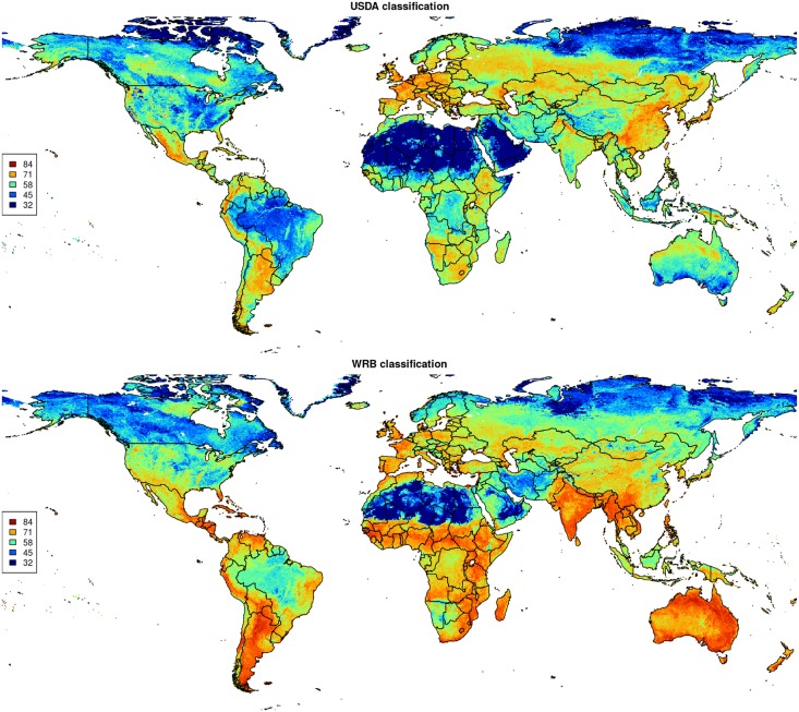
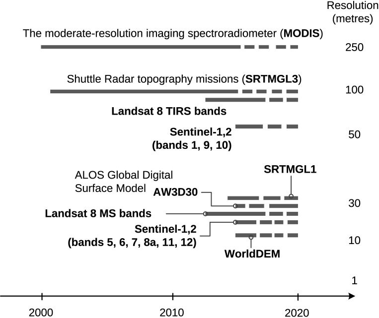
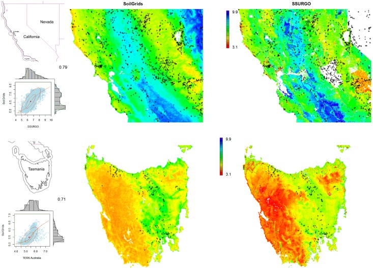
This paper describes the technical development and accuracy assessment of the most recent and improved version of the SoilGrids system at 250m resolution (June 2016 update). SoilGrids provides global predictions for standard numeric soil properties (organic carbon, bulk density, Cation Exchange Capacity (CEC), pH, soil texture fractions and coarse fragments) at seven standard depths (0, 5, 15, 30, 60, 100 and 200 cm), in addition to predictions of depth to bedrock and distribution of soil classes based on the World Reference Base (WRB) and USDA classification systems (ca. 280 raster layers in total). Predictions were based on ca. 150,000 soil profiles used for training and a stack of 158 remote sensing-based soil covariates (primarily derived from MODIS land products, SRTM DEM derivatives, climatic images and global landform and lithology maps), which were used to fit an ensemble of machine learning methods-random forest and gradient boosting and/or multinomial logistic regression-as implemented in the R packages ranger, xgboost, nnet and caret. The results of 10-fold cross-validation show that the ensemble models explain between 56% (coarse fragments) and 83% (pH) of variation with an overall average of 61%. Improvements in the relative accuracy considering the amount of variation explained, in comparison to the previous version of SoilGrids at 1 km spatial resolution, range from 60 to 230%. Improvements can be attributed to: (1) the use of machine learning instead of linear regression, (2) to considerable investments in preparing finer resolution covariate layers and (3) to insertion of additional soil profiles. Further development of SoilGrids could include refinement of methods to incorporate input uncertainties and derivation of posterior probability distributions (per pixel), and further automation of spatial modeling so that soil maps can be generated for potentially hundreds of soil variables. Another area of future research is the development of methods for multiscale merging of SoilGrids predictions with local and/or national gridded soil products (e.g. up to 50 m spatial resolution) so that increasingly more accurate, complete and consistent global soil information can be produced. SoilGrids are available under the Open Data Base License.
Overview
The claims and statistics of this paper haven’t been checked yet.
Free: it reads the open-access text and checks the first 5 claims that cite a source we can check. Create a free account to check every claim.
Integrity signals
Registry
Cites
Statistics
Figures






Verification
Claims the paper makes
The claims and statistics of this paper haven’t been checked yet.
Free: it reads the open-access text and checks the first 5 claims that cite a source we can check. Create a free account to check every claim.
Claims other papers make about this one
Each is checked against this paper’s own text: does it say what the citing paper says it does?
The source backs part of the claim, not all of it — or backs it for a different population, condition or comparison.
In the citing paper
“These uncertainties are mostly due to the uneven distribution and overall scarcity of field data for modelling and validating carbon stocks in the biomass and soil 27,64,65 .”
From Global priority areas for ecosystem restoration (2020) · cites this paper as [65]
Experimental — accuracy not yet measured
Self-check
Percentages, sums and reported differences re-computed from the paper’s own numbers.
The self-check needs the paper’s full text.
Citations
Cites
XGBoost: A Scalable Tree Boosting System
Chen, T., & Guestrin, C. (2016) · Proceedings of the 22nd ACM SIGKDD International Conference on Knowledge Discovery and Data Mining · doi:10.1145/2939672.2939785 · Cited by 54,569
Modern Applied Statistics with S
Venables, W. N., & Ripley, B. D. (2002) · Statistics and Computing · doi:10.1007/978-0-387-21706-2 · Cited by 24,305
Very high resolution interpolated climate surfaces for global land areas
Hijmans, R. J., Cameron, S. E., Parra, J. L., Jones, P. G., & Jarvis, A. (2005) · International Journal of Climatology · doi:10.1002/joc.1276 · Cited by 19,825
Total Carbon, Organic Carbon, and Organic Matter
Nelson, D. W., & Sommers, L. E. (1982) · Agronomy Monographs · doi:10.2134/agronmonogr9.2.2ed.c29 · Cited by 9,978
Building Predictive Models in R Using the caret Package
Kuhn, M. (2008) · Journal of Statistical Software · doi:10.18637/jss.v028.i05 · Cited by 8,863
Weighted kappa: nominal scale agreement provision for scaled disagreement or partial credit
Cohen, J. (1968) · Psychological Bulletin · doi:10.1037/h0026256 · Cited by 8,736
Kuhn, M., & Johnson, K. (2013) · doi:10.1007/978-1-4614-6849-3 · Cited by 6,788
Communication in the presence of noise
Shannon, C. E. (1949) · Proceedings of the IRE · doi:10.1109/jrproc.1949.232969 · Cited by 6,539
Anonim, A. (2010) · Cited by 4,945
Communication In The Presence Of Noise
Shannon, C. E. (1998) · Proceedings of the IEEE · doi:10.1109/jproc.1998.659497 · Cited by 4,804
Research works printed but not linked: 5
- D Arrouays, 2014, Soil carbon. vol. 125 of Advances in Agronomy, 93
- SA Lei, 1998, Soil Properties of the Kelso Sand Dunes in the Mojave Desert, The Southwestern Naturalist, 43, 47
- Huffman GJ, Bolvin DT. GPCP version 2 combined precipitation data set documentation. vol. 1. Laboratory for Atmospheres, NASA Goddard Space Flight Center and Science Systems and Applications; 2009.
- Kempen B. Updating soil information with digital soil mapping [PhD thesis]. Wageningen University. Wageningen; 2011. Available from: http://edepot.wur.nl/187198.
- Eberhardt E. Deriving WRB soil types using National German Soil Survey Guidelines. In: NCSS National Conference. NCSS Standards. Asheville, NC: United States Department of Agriculture USDA-NRCS; 2011. p. 1–2.
Cited by
Items 101–200 of 1,006
HYSOGs250m, global gridded hydrologic soil groups for curve-number-based runoff modeling
Ross, C. W., Prihodko, L., Anchang, J., Kumar, S., Ji, W., & Hanan, N. P. (2018) · Scientific Data · doi:10.1038/sdata.2018.91 · Cited by 271
Soil Property and Class Maps of the Conterminous United States at 100‐Meter Spatial Resolution
Ramcharan, A., Hengl, T., Nauman, T., Brungard, C., Waltman, S., Wills, S., & Thompson, J. (2018) · Soil Science Society of America Journal · doi:10.2136/sssaj2017.04.0122 · Cited by 269
“…selected for predictive modeling because (i) they have high prediction accuracies when modeling complex interactions among predictor variables (Cutler et al., 2007; Hengl et al., 2017) and (ii) they can be im- plemented in parallel, so that predictions can be generated for large volumes of pixels.”
BackgroundInfluentialGlobal biogeography and projection of soil antibiotic resistance genes
Zheng, D., Yin, G., Liu, M., Hou, L., Yang, Y., Van Boeckel, T. P., Zheng, Y., & Li, Y. (2022) · Science Advances · doi:10.1126/sciadv.abq8015 · Cited by 266
“Soils in these regions are characterized by relatively abundant organic carbon, phosphorus, and nitrogen contents (36).”
BackgroundDembélé, M., Hrachowitz, M., Savenije, H. H. G., Mariéthoz, G., & Schaefli, B. (2020) · Water Resources Research · doi:10.1029/2019wr026085 · Cited by 253
Uniting remote sensing, crop modelling and economics for agricultural risk management
Benami, E., Jin, Z., Carter, M. R., Ghosh, A., Hijmans, R. J., Hobbs, A., Kenduiywo, B., & Lobell, D. B. (2021) · Nature Reviews Earth & Environment · doi:10.1038/s43017-020-00122-y · Cited by 249
Global variation in soil carbon sequestration potential through improved cropland management
Lessmann, M., Ros, G. H., Young, M. D., & de Vries, W. (2022) · Global Change Biology · doi:10.1111/gcb.15954 · Cited by 257
Artificial intelligence in environmental monitoring: in-depth analysis
Alotaibi, E., & Nassif, N. (2024) · Discover Artificial Intelligence · doi:10.1007/s44163-024-00198-1 · Cited by 212
“This study highlighted the potential for AI to enhance soil and land management practices by improving the resolution and accuracy of soil maps, which are critical for sustainable agriculture and land use planning [18].”
Amatulli, G., McInerney, D., Sethi, T., Strobl, P., & Domisch, S. (2020) · Scientific Data · doi:10.1038/s41597-020-0479-6 · Cited by 247
GIFT – A Global Inventory of Floras and Traits for macroecology and biogeography
Weigelt, P., König, C., & Kreft, H. (2020) · Journal of Biogeography · doi:10.1111/jbi.13623 · Cited by 268
Species distribution modelling to support forest management. A literature review
Pecchi, M., Marchi, M., Burton, V., Giannetti, F., Moriondo, M., Bernetti, I., Bindi, M., & Chirici, G. (2019) · Ecological Modelling · doi:10.1016/j.ecolmodel.2019.108817 · Cited by 243
Land susceptibility to water and wind erosion risks in the East Africa region
Fenta, A. A., Tsunekawa, A., Haregeweyn, N., Poesen, J., Tsubo, M., Borrelli, P., Panagos, P., Vanmaercke, M., Broeckx, J., Yasuda, H., et al. (2020) · Science of The Total Environment · doi:10.1016/j.scitotenv.2019.135016 · Cited by 245
Large-sample hydrology: recent progress, guidelines for new datasets and grand challenges
Addor, N., Do, H. X., Alvarez-Garreton, C., Coxon, G., Fowler, K., & Mendoza, P. A. (2020) · Hydrological Sciences Journal · doi:10.1080/02626667.2019.1683182 · Cited by 234
“…uncertainties using the spread among products, several products now provide uncertainty estimates for their own data (e.g. Newman et al. 2015b, Hengl et al. 2017, Cornes et al. 2018, Chaney et al. 2019), and recent coordinated efforts provide guidance on how to conduct streamflow uncertainty…”
BackgroundKang, Y., Ozdogan, M., Zhu, X., Ye, Z., Hain, C., & Anderson, M. (2020) · Environmental Research Letters · doi:10.1088/1748-9326/ab7df9 · Cited by 238
“Random forest and XGBoost are the most widely used machine learning algorithms in Geoscience and other areas (Anderson and Lucas 2018, Fern ´ andez-Delgado et al 2019, Hengl et al 2017; Shangguan et al 2017).”
BackgroundMethodDigital mapping of peatlands – A critical review
Minasny, B., Berglund, Ö., Connolly, J., Hedley, C., de Vries, F., Gimona, A., Kempen, B., Kidd, D., Lilja, H., Malone, B., et al. (2019) · Earth-Science Reviews · doi:10.1016/j.earscirev.2019.05.014 · Cited by 233
Self-citationA Global High‐Resolution Data Set of Soil Hydraulic and Thermal Properties for Land Surface Modeling
Dai, Y., Xin, Q., Wei, N., Zhang, Y., Shangguan, W., Yuan, H., Zhang, S., Liu, S., & Lu, X. (2019) · Journal of Advances in Modeling Earth Systems · doi:10.1029/2019ms001784 · Cited by 240
“21; FAO/IIASA/ISRIC/ISS‐ CAS/JRC, 2012), Global Soil Dataset for Earth System Models (GSDE; Shangguan et al., 2014), SoilGrids (Hengl et al., 2014, 2017), POLARIS (Chaney et al., 2016, 2019), and USA48 SoilGrids100m+ (Ramcharan et al., 2018).”
BackgroundSelf-citationMapping Geospatial Processes Affecting the Environmental Fate of Agricultural Pesticides in Africa
Hendriks, C. M. J., Gibson, H. S., Trett, A., Python, A., Weiss, D. J., Vrieling, A., Coleman, M., Gething, P. W., Hancock, P. A., & Moyes, C. L. (2019) · International Journal of Environmental Research and Public Health · doi:10.3390/ijerph16193523 · Cited by 238
“Leaching Soil drainage rate Soil drainage class [44] Groundwater depth Groundwater depth [45] Depth to bedrock Depth to bedrock [46] Type of bedrock Soil drainage class [46] Slope Slope [47] Soil moisture Soil moisture [48]”
BackgroundInfluentialThe global potential for increased storage of carbon on land
Walker, W. S., Gorelik, S. R., Cook-Patton, S. C., Baccini, A., Farina, M. K., Solvik, K. K., Ellis, P. W., Sanderman, J., Houghton, R. A., Leavitt, S. M., et al. (2022) · Proceedings of the National Academy of Sciences · doi:10.1073/pnas.2111312119 · Cited by 237
Luo, Z., Wang, G., & Wang, E. (2019) · Nature Communications · doi:10.1038/s41467-019-11597-9 · Cited by 229
Mapping co-benefits for carbon storage and biodiversity to inform conservation policy and action
Soto-Navarro, C., Ravilious, C., Arnell, A., de Lamo, X., Harfoot, M., Hill, S. L. L., Wearn, O. R., Santoro, M., Bouvet, A., Mermoz, S., et al. (2020) · Philosophical Transactions of the Royal Society B: Biological Sciences · doi:10.1098/rstb.2019.0128 · Cited by 228
Agricultural pesticide land budget and river discharge to oceans
Maggi, F., Tang, F. H. M., & Tubiello, F. N. (2023) · Nature · doi:10.1038/s41586-023-06296-x · Cited by 224
Global influence of soil texture on ecosystem water limitation
Wankmüller, F. J. P., Delval, L., Lehmann, P., Baur, M. J., Cecere, A., Wolf, S., Or, D., Javaux, M., & Carminati, A. (2024) · Nature · doi:10.1038/s41586-024-08089-2 · Cited by 197
“Next, the global map of Δ θ crit resulting from changing climate ( T pot ) was calculated as follows: in a first step, global maps of sand and clay content from SoilGrids 83 were used to determine a global map of soil textural classes (Extended Data Fig.”
Solly, E. F., Weber, V., Zimmermann, S., Walthert, L., Hagedorn, F., & Schmidt, M. W. I. (2020) · Frontiers in Forests and Global Change · doi:10.3389/ffgc.2020.00098 · Cited by 203
Nouri, H., Stokvis, B., Galindo, A., Blatchford, M., & Hoekstra, A. Y. (2019) · Science of The Total Environment · doi:10.1016/j.scitotenv.2018.10.311 · Cited by 227
Nelson, J. A., Pérez‐Priego, O., Zhou, S., Poyatos, R., Zhang, Y., Blanken, P. D., Gimeno, T. E., Wohlfahrt, G., Desai, A. R., Gioli, B., et al. (2020) · Global Change Biology · doi:10.1111/gcb.15314 · Cited by 225
“Soil data were derived from the SOILGRIDS dataset (Hengl et al., 2017) 6926 | NELSON Et aL. the peak growing season have the highest impact on estimated T.”
MethodTaghizadeh-Mehrjardi, R., Schmidt, K., Amirian-Chakan, A., Rentschler, T., Zeraatpisheh, M., Sarmadian, F., Valavi, R., Davatgar, N., Behrens, T., & Scholten, T. (2020) · Remote Sensing · doi:10.3390/rs12071095 · Cited by 223
“in Sub-Saharan Africa [105], soil properties in the United States [106], soil pH in China [107], soil properties at the global scale [108], and the depth to bedrock at the global scale [109].”
BackgroundMapping the permafrost stability on the Tibetan Plateau for 2005–2015
Ran, Y., Li, X., Cheng, G., Nan, Z., Che, J., Sheng, Y., Wu, Q., Jin, H., Luo, D., Tang, Z., et al. (2021) · Science China Earth Sciences · doi:10.1007/s11430-020-9685-3 · Cited by 223
“It was developed by the International Soil Reference and Information Center (ISRIC) as part of the World Soil Information (WSI) within the Global Soil Information Facilities (GSIF) framework as a result of broad international collaboration (Hengl et al., 2017).”
BackgroundPoorter, L., Rozendaal, D. M. A., Bongers, F., de Almeida-Cortez, J. S., Almeyda Zambrano, A. M., Álvarez, F. S., Andrade, J. L., Villa, L. F. A., Balvanera, P., Becknell, J. M., et al. (2019) · Nature Ecology & Evolution · doi:10.1038/s41559-019-0882-6 · Cited by 224
Machine learning in space and time for modelling soil organic carbon change
Heuvelink, G. B. M., Angelini, M. E., Poggio, L., Bai, Z., Batjes, N. H., van den Bosch, R., Bossio, D., Estella, S., Lehmann, J., Olmedo, G. F., et al. (2021) · European Journal of Soil Science · doi:10.1111/ejss.12998 · Cited by 224
Self-citationEuropean Soil Data Centre 2.0: Soil data and knowledge in support of the EU policies
Panagos, P., Van Liedekerke, M., Borrelli, P., Köninger, J., Ballabio, C., Orgiazzi, A., Lugato, E., Liakos, L., Hervas, J., Jones, A., et al. (2022) · European Journal of Soil Science · doi:10.1111/ejss.13315 · Cited by 215
“LUCAS topsoil database have also contributed to the development of other global maps of soil properties such as SoilGrids (Hengl et al., 2017; Poggio et al., 2021).”
MethodMachine Learning to Estimate Surface Soil Moisture from Remote Sensing Data
Adab, H., Morbidelli, R., Saltalippi, C., Moradian, M., & Ghalhari, G. A. F. (2020) · Water · doi:10.3390/w12113223 · Cited by 222
“Sampling points were also determined based on a map of World Reference Base (2006) Soil Groups produced by SoilGrids project [48].”
MethodA bioavailable strontium isoscape for Western Europe: A machine learning approach
Bataille, C. P., von Holstein, I. C. C., Laffoon, J. E., Willmes, M., Liu, X.-M., & Davies, G. R. (2018) · PLOS ONE · doi:10.1371/journal.pone.0197386 · Cited by 203
“orc Soil organic carbon (weight %) 250 m C [44] r.”
BackgroundInfluentialTifafi, M., Guenet, B., & Hatté, C. (2018) · Global Biogeochemical Cycles · doi:10.1002/2017gb005678 · Cited by 214
“%)) for each standard layer (0–5 cm, 5–15 cm, 15–30 cm, 30–60 cm, and 60–100 cm) as below, according to Hengl et al. (2017): OCCa b ¼ 12 1 b a X b að Þ OCCa þ OCCbð Þ (1) BDa b ¼ 12 1 b a X b að Þ BDa þ BDbð Þ (2) Ga b ¼ 12 1 b a X b að Þ Ga þ Gbð Þ (3) where a and b are the lower and upper limits,…”
BackgroundMethodVelazco, S. J. E., Villalobos, F., Galvão, F., & De Marco Júnior, P. (2019) · Diversity and Distributions · doi:10.1111/ddi.12886 · Cited by 204
“We used six soil variables re‐ lated to physical soil properties provided by the SoilGrids (Hengl et al., 2017) with 0.75 arc‐seconds resolution (c. 250 m), which were upscaled to 5 arc‐min (c. 10 km) by taking the average value of higher resolution cells into lower resolution cells.”
MethodInfluentialThe Importance of Consistent Global Forest Aboveground Biomass Product Validation
Duncanson, L., Armston, J., Disney, M., Avitabile, V., Barbier, N., Calders, K., Carter, S., Chave, J., Herold, M., Crowther, T. W., et al. (2019) · Surveys in Geophysics · doi:10.1007/s10712-019-09538-8 · Cited by 213
Recent progress and future prospect of digital soil mapping: A review
ZHANG, G.-L., LIU, F., & SONG, X.-D. (2017) · Journal of Integrative Agriculture · doi:10.1016/s2095-3119(17)61762-3 · Cited by 206
Chaney, N. W., Minasny, B., Herman, J. D., Nauman, T. W., Brungard, C. W., Morgan, C. L. S., McBratney, A. B., Wood, E. F., & Yimam, Y. (2019) · Water Resources Research · doi:10.1029/2018wr022797 · Cited by 209
“These DSM efforts are leading to the emergence of multiple continental and global data sets at spatial resolutions between 30 m and 1 km (Arrouays et al., 2014; Chaney et al., 2016; Hengl et al., 2017; Ramcharan et al., 2017; Sanchez et al., 2009).”
BackgroundPhylogenomic and ecological analyses reveal the spatiotemporal evolution of global pines
Jin, W.-T., Gernandt, D. S., Wehenkel, C., Xia, X.-M., Wei, X.-X., & Wang, X.-Q. (2021) · Proceedings of the National Academy of Sciences · doi:10.1073/pnas.2022302118 · Cited by 205
“org/landcover) (87) as well as annual potential evapotranspiration and aridity index (https:// cgiarcsi.”
BackgroundWoSIS: providing standardised soil profile data for the world
Batjes, N. H., Ribeiro, E., van Oostrum, A., Leenaars, J., Hengl, T., & Mendes de Jesus, J. (2017) · Earth System Science Data · doi:10.5194/essd-9-1-2017 · Cited by 206
Self-citationApplication of machine-learning methods in forest ecology: recent progress and future challenges
Liu, Z., Peng, C., Work, T., Candau, J.-N., DesRochers, A., & Kneeshaw, D. (2018) · Environmental Reviews · doi:10.1139/er-2018-0034 · Cited by 201
“(mostly after ecology and ML methods were also used in hazard assessment and forest management (Rogan et al. 2008; Hlásny et al. 2011; Hlásny and Turčáni 2013; Fassnacht et al. 2014; Bai et al. 2014; Satir et al. 2016; Vahedi 2016; Hengl et al. 2017).”
MethodWhy increased extreme precipitation under climate change negatively affects water security
Eekhout, J. P. C., Hunink, J. E., Terink, W., & de Vente, J. (2018) · Hydrology and Earth System Sciences · doi:10.5194/hess-22-5935-2018 · Cited by 199
Size, distribution, and vulnerability of the global soil inorganic carbon
Huang, Y., Song, X., Wang, Y.-P., Canadell, J. G., Luo, Y., Ciais, P., Chen, A., Hong, S., Wang, Y., Tao, F., et al. (2024) · Science · doi:10.1126/science.adi7918 · Cited by 198
Global patterns and drivers of soil total phosphorus concentration
He, X., Augusto, L., Goll, D. S., Ringeval, B., Wang, Y., Helfenstein, J., Huang, Y., Yu, K., Wang, Z., Yang, Y., et al. (2021) · Earth System Science Data · doi:10.5194/essd-13-5831-2021 · Cited by 197
Chen, S., Liang, Z., Webster, R., Zhang, G., Zhou, Y., Teng, H., Hu, B., Arrouays, D., & Shi, Z. (2019) · Science of The Total Environment · doi:10.1016/j.scitotenv.2018.11.230 · Cited by 201
Doubling of annual forest carbon loss over the tropics during the early twenty-first century
Feng, Y., Zeng, Z., Searchinger, T. D., Ziegler, A. D., Wu, J., Wang, D., He, X., Elsen, P. R., Ciais, P., Xu, R., et al. (2022) · Nature Sustainability · doi:10.1038/s41893-022-00854-3 · Cited by 197
Global patterns of vascular plant alpha diversity
Sabatini, F. M., Jiménez-Alfaro, B., Jandt, U., Chytrý, M., Field, R., Kessler, M., Lenoir, J., Schrodt, F., Wiser, S. K., Arfin Khan, M. A. S., et al. (2022) · Nature Communications · doi:10.1038/s41467-022-32063-z · Cited by 192
Rewetting global wetlands effectively reduces major greenhouse gas emissions
Zou, J., Ziegler, A. D., Chen, D., McNicol, G., Ciais, P., Jiang, X., Zheng, C., Wu, J., Wu, J., Lin, Z., et al. (2022) · Nature Geoscience · doi:10.1038/s41561-022-00989-0 · Cited by 194
3D soil hydraulic database of Europe at 250 m resolution
Tóth, B., Weynants, M., Pásztor, L., & Hengl, T. (2017) · Hydrological Processes · doi:10.1002/hyp.11203 · Cited by 185
A review of the global soil property maps for Earth system models
Dai, Y., Shangguan, W., Wei, N., Xin, Q., Yuan, H., Zhang, S., Liu, S., Lu, X., Wang, D., & Yan, F. (2019) · SOIL · doi:10.5194/soil-5-137-2019 · Cited by 193
Self-citationPrevalence and drivers of abrupt vegetation shifts in global drylands
Berdugo, M., Gaitán, J. J., Delgado-Baquerizo, M., Crowther, T. W., & Dakos, V. (2022) · Proceedings of the National Academy of Sciences · doi:10.1073/pnas.2123393119 · Cited by 192
Managed aquifer recharge implementation criteria to achieve water sustainability
Alam, S., Borthakur, A., Ravi, S., Gebremichael, M., & Mohanty, S. K. (2021) · Science of The Total Environment · doi:10.1016/j.scitotenv.2021.144992 · Cited by 193
Schillaci, C., Acutis, M., Lombardo, L., Lipani, A., Fantappiè, M., Märker, M., & Saia, S. (2017) · Science of The Total Environment · doi:10.1016/j.scitotenv.2017.05.239 · Cited by 197
Zhang, Y., Schaap, M. G., & Zha, Y. (2018) · Water Resources Research · doi:10.1029/2018wr023539 · Cited by 191
“Similar to Hengl et al. (2014), these maps have a 1-km resolution, but coarser (Montzka et al., 2017) or finer (250-m resolution, see Hengl et al., 2017) resolutions can also be generated.”
BackgroundImportant role of Fe oxides in global soil carbon stabilization and stocks
Jia, N., Li, L., Guo, H., & Xie, M. (2024) · Nature Communications · doi:10.1038/s41467-024-54832-8 · Cited by 175
“However, only global data on the soil clay content 25 and mineral composition 26,27 are currently available, and information on the global distribution of Fe-Al oxides is lacking.”
Decipher soil organic carbon dynamics and driving forces across China using machine learning
Li, H., Wu, Y., Liu, S., Xiao, J., Zhao, W., Chen, J., Alexandrov, G., & Cao, Y. (2022) · Global Change Biology · doi:10.1111/gcb.16154 · Cited by 189
Global variation in the fraction of leaf nitrogen allocated to photosynthesis
Luo, X., Keenan, T. F., Chen, J. M., Croft, H., Colin Prentice, I., Smith, N. G., Walker, A. P., Wang, H., Wang, R., Xu, C., et al. (2021) · Nature Communications · doi:10.1038/s41467-021-25163-9 · Cited by 186
LamaH-CE: LArge-SaMple DAta for Hydrology and Environmental Sciences for Central Europe
Klingler, C., Schulz, K., & Herrnegger, M. (2021) · Earth System Science Data · doi:10.5194/essd-13-4529-2021 · Cited by 168
“Data from soil profiles are integrated into 3DSHD (Hengl et al., 2017; Toth et al., 2017) and the dataset of Pelletier et al. (2016) as well but are rather used for calibration and validation.”
MethodA deep learning-based hybrid model of global terrestrial evaporation
Koppa, A., Rains, D., Hulsman, P., Poyatos, R., & Miralles, D. G. (2022) · Nature Communications · doi:10.1038/s41467-022-29543-7 · Cited by 181
Toward seamless hydrologic predictions across spatial scales
Samaniego, L., Kumar, R., Thober, S., Rakovec, O., Zink, M., Wanders, N., Eisner, S., Müller Schmied, H., Sutanudjaja, E. H., Warrach-Sagi, K., et al. (2017) · Hydrology and Earth System Sciences · doi:10.5194/hess-21-4323-2017 · Cited by 178
Global models and predictions of plant diversity based on advanced machine learning techniques
Cai, L., Kreft, H., Taylor, A., Denelle, P., Schrader, J., Essl, F., van Kleunen, M., Pergl, J., Pyšek, P., Stein, A., et al. (2023) · New Phytologist · doi:10.1111/nph.18533 · Cited by 184
Accurate and Precise Prediction of Soil Properties from a Large Mid-Infrared Spectral Library
Dangal, S. R. S., Sanderman, J., Wills, S., & Ramirez-Lopez, L. (2019) · Soil Systems · doi:10.3390/soilsystems3010011 · Cited by 179
“[65] indicated that 150 trees are optimal to achieve a stable random forest model, beyond which a trade-off between the computation time and model accuracy offers no additional benefits.”
BackgroundAraya, S. N., & Ghezzehei, T. A. (2019) · Water Resources Research · doi:10.1029/2018wr024357 · Cited by 180
“Hengl et al. (2017), for example, used RF and BRT among an ensemble of other models to Indicates the size distribution of pores.”
MethodObserved and projected changes in global climate zones based on Köppen climate classification
Cui, D., Liang, S., & Wang, D. (2021) · WIREs Climate Change · doi:10.1002/wcc.701 · Cited by 166
Towards globally customizable ecosystem service models
Martínez-López, J., Bagstad, K. J., Balbi, S., Magrach, A., Voigt, B., Athanasiadis, I., Pascual, M., Willcock, S., & Villa, F. (2019) · Science of The Total Environment · doi:10.1016/j.scitotenv.2018.09.371 · Cited by 180
Satellite observations document trends consistent with a boreal forest biome shift
Berner, L. T., & Goetz, S. J. (2022) · Global Change Biology · doi:10.1111/gcb.16121 · Cited by 182
“Additional predictors included mean annual surface soil temperature from 2000 to 2016 (Obu et al., 2018) and soil nitrogen content at standard depths (0– 5 cm, 5– 15 cm, 15– 30 cm) (Hengl et al., 2017).”
BackgroundSampling design optimization for soil mapping with random forest
Wadoux, A. M. J.-C., Brus, D. J., & Heuvelink, G. B. M. (2019) · Geoderma · doi:10.1016/j.geoderma.2019.113913 · Cited by 179
Self-citationZhou, T., Geng, Y., Ji, C., Xu, X., Wang, H., Pan, J., Bumberger, J., Haase, D., & Lausch, A. (2021) · Science of The Total Environment · doi:10.1016/j.scitotenv.2020.142661 · Cited by 180
Biodiversity loss reduces global terrestrial carbon storage
Weiskopf, S. R., Isbell, F., Arce-Plata, M. I., Di Marco, M., Harfoot, M., Johnson, J., Lerman, S. B., Miller, B. W., Morelli, T. L., Mori, A. S., et al. (2024) · Nature Communications · doi:10.1038/s41467-024-47872-7 · Cited by 181
“…2006 subgroup soil classi fi cation (ISRIC, https://data.isric.org/geonetwork/srv/eng/catalog.search#/metadata/ 5c301e97-9662-4f77-aa2d-48facd3c9e14 83 ); to the same resolution as the cSoil raster layer using the nearest neighbor method in the R software program terra package 84 , and then masked…”
Spatial prediction of soil organic carbon using machine learning techniques in western Iran
Mahmoudzadeh, H., Matinfar, H. R., Taghizadeh-Mehrjardi, R., & Kerry, R. (2020) · Geoderma Regional · doi:10.1016/j.geodrs.2020.e00260 · Cited by 182
Direct and lagged climate change effects intensified the 2022 European drought
Bevacqua, E., Rakovec, O., Schumacher, D. L., Kumar, R., Thober, S., Samaniego, L., Seneviratne, S. I., & Jakob Zscheischler, A. (2024) · Nature Geoscience · doi:10.1038/s41561-024-01559-2 · Cited by 179
Diversity-dependent temporal divergence of ecosystem functioning in experimental ecosystems
Guerrero-Ramírez, N. R., Craven, D., Reich, P. B., Ewel, J. J., Isbell, F., Koricheva, J., Parrotta, J. A., Auge, H., Erickson, H. E., Forrester, D. I., et al. (2017) · Nature Ecology & Evolution · doi:10.1038/s41559-017-0325-1 · Cited by 178
Infiltration from the Pedon to Global Grid Scales: An Overview and Outlook for Land Surface Modeling
Vereecken, H., Weihermüller, L., Assouline, S., Šimůnek, J., Verhoef, A., Herbst, M., Archer, N., Mohanty, B., Montzka, C., Vanderborght, J., et al. (2019) · Vadose Zone Journal · doi:10.2136/vzj2018.10.0191 · Cited by 170
“OLAMSOIL uses the SoilGrids data published by Hengl et al. (2014, 2017).”
MethodFine resolution map of top- and subsoil carbon sequestration potential in France
Chen, S., Martin, M. P., Saby, N. P. A., Walter, C., Angers, D. A., & Arrouays, D. (2018) · Science of The Total Environment · doi:10.1016/j.scitotenv.2018.02.209 · Cited by 174
Towards hybrid modeling of the global hydrological cycle
Kraft, B., Jung, M., Körner, M., Koirala, S., & Reichstein, M. (2022) · Hydrology and Earth System Sciences · doi:10.5194/hess-26-1579-2022 · Cited by 173
Impressions of digital soil maps: The good, the not so good, and making them ever better
Arrouays, D., McBratney, A., Bouma, J., Libohova, Z., Richer-de-Forges, A. C., Morgan, C. L. S., Roudier, P., Poggio, L., & Mulder, V. L. (2020) · Geoderma Regional · doi:10.1016/j.geodrs.2020.e00255 · Cited by 173
Xing, Z., Fan, L., Zhao, L., De Lannoy, G., Frappart, F., Peng, J., Li, X., Zeng, J., Al-Yaari, A., Yang, K., et al. (2021) · Remote Sensing of Environment · doi:10.1016/j.rse.2021.112666 · Cited by 173
Multi-algorithm comparison for predicting soil salinity
Wang, F., Shi, Z., Biswas, A., Yang, S., & Ding, J. (2020) · Geoderma · doi:10.1016/j.geoderma.2020.114211 · Cited by 169
Effect of climate warming on the timing of autumn leaf senescence reverses after the summer solstice
Zohner, C. M., Mirzagholi, L., Renner, S. S., Mo, L., Rebindaine, D., Bucher, R., Palouš, D., Vitasse, Y., Fu, Y. H., Stocker, B. D., et al. (2023) · Science · doi:10.1126/science.adf5098 · Cited by 165
Soil legacy data rescue via GlobalSoilMap and other international and national initiatives
Arrouays, D., Leenaars, J. G. B., Richer-de-Forges, A. C., Adhikari, K., Ballabio, C., Greve, M., Grundy, M., Guerrero, E., Hempel, J., Hengl, T., et al. (2017) · GeoResJ · doi:10.1016/j.grj.2017.06.001 · Cited by 169
Self-citationGiuliani, G., Mazzetti, P., Santoro, M., Nativi, S., Van Bemmelen, J., Colangeli, G., & Lehmann, A. (2020) · International Journal of Applied Earth Observation and Geoinformation · doi:10.1016/j.jag.2020.102068 · Cited by 163
Development and analysis of the Soil Water Infiltration Global database
Rahmati, M., Weihermüller, L., Vanderborght, J., Pachepsky, Y. A., Mao, L., Sadeghi, S. H., Moosavi, N., Kheirfam, H., Montzka, C., Van Looy, K., et al. (2018) · Earth System Science Data · doi:10.5194/essd-10-1237-2018 · Cited by 169
Minimising soil organic carbon erosion by wind is critical for land degradation neutrality
Chappell, A., Webb, N. P., Leys, J. F., Waters, C. M., Orgill, S., & Eyres, M. J. (2019) · Environmental Science & Policy · doi:10.1016/j.envsci.2018.12.020 · Cited by 163
“) from the SoilGrids dataset (Hengl et al., 2017).”
MethodSapkota, T. B., Jat, M. L., Rana, D. S., Khatri‐Chhetri, A., Jat, H. S., Bijarniya, D., Sutaliya, J. M., Kumar, M., Singh, L. K., Jat, R. K., et al. (2021) · Scientific Reports · doi:10.1038/s41598-020-79883-x · Cited by 170
High aboveground carbon stock of African tropical montane forests
Cuní‐Sanchez, A., Sullivan, M. J. P., Platts, P. J., Lewis, S. L., Marchant, R., Imani, G., Hubau, W., Abiem, I., Adhikari, H., Albrecht, T., et al. (2021) · Nature · doi:10.1038/s41586-021-03728-4 · Cited by 181
NeuralHydrology – Interpreting LSTMs in Hydrology
Kratzert, F., Herrnegger, M., Klotz, D., Hochreiter, S., & Klambauer, G. (2019) · Lecture Notes in Computer Science · doi:10.1007/978-3-030-28954-6_19 · Cited by 129
30% land conservation and climate action reduces tropical extinction risk by more than 50%
Hannah, L., Roehrdanz, P. R., Marquet, P. A., Enquist, B. J., Midgley, G., Foden, W., Lovett, J. C., Corlett, R. T., Corcoran, D., Butchart, S. H. M., et al. (2020) · Ecography · doi:10.1111/ecog.05166 · Cited by 164
Beck, H. E., Pan, M., Lin, P., Seibert, J., van Dijk, A. I. J. M., & Wood, E. F. (2020) · Journal of Geophysical Research: Atmospheres · doi:10.1029/2019jd031485 · Cited by 109
“jp/~yamadai/ MERIT_DEM/) Sand Soil sand content (%), average over all layers 250m SoilGrids250m (Hengl et al., 2017) (https://soilgrids.”
BackgroundPervasive changes in stream intermittency across the United States
Zipper, S. C., Hammond, J. C., Shanafield, M., Zimmer, M., Datry, T., Jones, C. N., Kaiser, K. E., Godsey, S. E., Burrows, R. M., Blaszczak, J. R., et al. (2021) · Environmental Research Letters · doi:10.1088/1748-9326/ac14ec · Cited by 159
Machine Learning-Based CYGNSS Soil Moisture Estimates over ISMN sites in CONUS
Senyurek, V., Lei, F., Boyd, D., Kurum, M., Gurbuz, A. C., & Moorhead, R. (2020) · Remote Sensing · doi:10.3390/rs12071168 · Cited by 161
“The Global Gridded Soil Information (SoilGrids) [31] is used to represent soil texture that controls hydraulic properties such as water retention and capillary action within the profile.”
MethodImproved global-scale predictions of soil carbon stocks with Millennial Version 2
Abramoff, R., Guenet, B., Zhang, H., Georgiou, K., Xu, X., Rossel, R. A. V., Yuan, W., & Ciais, P. (2021) · Soil Biology and Biochemistry · doi:10.1016/j.soilbio.2021.108466 · Cited by 175
Majority of global river flow sustained by groundwater
Xie, J., Liu, X., Jasechko, S., Berghuijs, W. R., Wang, K., Liu, C., Reichstein, M., Jung, M., & Koirala, S. (2024) · Nature Geoscience · doi:10.1038/s41561-024-01483-5 · Cited by 199
Soil bulk density assessment in Europe
Panagos, P., Rosa, D. D., Liakos, L., Labouyrie, M., Borrelli, P., & Ballabio, C. (2024) · Agriculture Ecosystems & Environment · doi:10.1016/j.agee.2024.108907 · Cited by 192
Spatio-temporal downscaling of gridded crop model yield estimates based on machine learning
Folberth, C., Baklanov, A., Balkovič, J., Skalský, R., Khabarov, N., & Obersteiner, M. (2019) · Agricultural and Forest Meteorology · doi:10.1016/j.agrformet.2018.09.021 · Cited by 161
Yunus, A. P., Fan, X., Tang, X., Jie, D., Xu, Q., & Huang, R. (2019) · Remote Sensing of Environment · doi:10.1016/j.rse.2019.111476 · Cited by 160
A restructured and updated global soil respiration database (SRDB-V5)
Jian, J., Vargas, R., Anderson‐Teixeira, K. J., Stell, E., Herrmann, V., Horn, M., Kholod, N., Manzon, J., Marchesi, R., Paredes, D., et al. (2021) · Earth system science data · doi:10.5194/essd-13-255-2021 · Cited by 177
Self-citationGlobal patterns of geo-ecological controls on the response of soil respiration to warming
Haaf, D., Six, J., & Doetterl, S. (2021) · Nature Climate Change · doi:10.1038/s41558-021-01068-9 · Cited by 158
Chen, J., Wu, T., Zou, D., Liu, L., Wu, X., Gong, W., Zhu, X., Li, R., Hao, J., Hu, G., et al. (2021) · Remote Sensing of Environment · doi:10.1016/j.rse.2021.112778 · Cited by 160
Mapping safe drinking water use in low- and middle-income countries
Greenwood, E. E., Lauber, T., van den Hoogen, J., Donmez, A., Bain, R., Johnston, R., Crowther, T. W., & Julian, T. R. (2024) · Science · doi:10.1126/science.adh9578 · Cited by 190
Liu, L., Zhu, K., Wurzburger, N., & Zhang, J. (2020) · Ecosphere · doi:10.1002/ecs2.2999 · Cited by 172
Drivers and trends of global soil microbial carbon over two decades
Patoine, G., Eisenhauer, N., Cesarz, S., Phillips, H. R. P., Xu, X., Zhang, L., & Guerra, C. A. (2022) · Nature Communications · doi:10.1038/s41467-022-31833-z · Cited by 183
“Soil property layers for organic carbon, total nitrogen, pH, sand proportion, and clay proportion were from the SoilGrids 250 m resolution data set 48 .”
Identifying areas at risk of drought‐induced tree mortality across South‐Eastern Australia
Kauwe, M. G. D., Medlyn, B. E., Ukkola, A., Mu, M., Sabot, M. E. B., Pitman, A. J., Meir, P., Cernusak, L. A., Rifai, S. W., Choat, B., et al. (2020) · Global Change Biology · doi:10.1111/gcb.15215 · Cited by 172
“As is standard in CABLE, we assumed vertically uniform soil texture based on the weighted average of the 2 m SoilGrids data.”
Method
Metadata
- Authors
- Hengl, T., Mendes de Jesus, J., Heuvelink, G. B. M., Ruiperez Gonzalez, M., Kilibarda, M., Blagotić, A., Shangguan, W., Wright, M. N., Geng, X., Bauer-Marschallinger, B., Guevara, M. A., Vargas, R., MacMillan, R. A., Batjes, N. H., Leenaars, J. G. B., Ribeiro, E., Wheeler, I., Mantel, S., & Kempen, B.
- Affiliations
- ISRIC - World Soil Information (NL)
- University of Belgrade (RS)
- Sun Yat-sen University (CN)
- University of Lübeck (DE)
- Agriculture and Agri-Food Canada (CA)
- TU Wien (AT)
- University of Delaware (US)
- ORCID
- Venue
- PLOS ONE
- Publisher
- Public Library of Science (PLoS)
- Published
- 2017-02-16
- Volume
- 12
- Issue
- 2
- Pages
- e0169748
- ISSN
- 1932-6203 (ISSN-L)
- PMC
- PMC5313206
- OpenAlex
- W2588003345
- Cited by
- 4,733
- References
- 89
- Citations by year
- 2026: 591 · 2025: 654 · 2024: 610 · 2023: 634 · 2022: 669 · 2021: 672 · 2020: 402 · 2019: 265 · 2018: 173 · 2017: 56
- FWCI
- 137.14
- Type
- journal article
- Language
- en
- Open access
- gold
- doi.org
- Licence
- Locations
- PLoS ONE (publishedVersion, cc-by)
- PubMed Central (publishedVersion, cc-by)
- PubMed (publishedVersion)
- RePEc: Research Papers in Economics (submittedVersion)
- DOAJ (DOAJ: Directory of Open Access Journals) (submittedVersion)
- GraFar (University of Belgrade, Faculty of Civil Engineering) (submittedVersion, cc-by)
- Socio-Environmental Systems Modeling (submittedVersion, cc-by)
- Data Archiving and Networked Services (DANS) (submittedVersion, other-oa)
- Topics
- Life Sciences › Agricultural and Biological Sciences › Soil Science › Soil Geostatistics and Mapping
- Physical Sciences › Environmental Science › Environmental Engineering › Soil Moisture and Remote Sensing
- Physical Sciences › Environmental Science › Management, Monitoring, Policy and Law › Soil and Land Suitability Analysis
- Keywords
- SoilGrids, soil properties, soil organic carbon, soil bulk density, cation exchange capacity, soil pH, soil texture, coarse fragments, bedrock depth, soil classification, USDA soil classification, MODIS, random forest, gradient boosting, multinomial logistic regression, ensemble learning, accuracy assessment, soil mapping
- MeSH terms
- Machine Learning, Algorithms, Conservation of Natural Resources, Environmental Monitoring, Humans, Models, Theoretical, Soil, Geographic Information Systems
About these checks
Registry, retraction, Cites and statistics results are computed, not judged, with one exception: a printed reference that no index lists is read once by a model before it counts as a citation error. Claims are extracted by a model and kept only when their quote appears verbatim in the text; each cited source is then checked, with a model’s help, for whether it says what the claim relies on. Those verdicts can be wrong — read the claim’s quote and the cited source before relying on one.
Statistics and arithmetic are recomputed, not judged.
Confidence bands are shown only for fields calibrated on our annotated test set. None is calibrated yet, so no band is shown.
What counts as a claim ›How we measure confidence ›How we check this ›
Are you an author, or do you see a problem with this page? Request a review
Data sources
Bibliographic data: Semantic Scholar, OpenAlex, Crossref.
Contains information from the Semantic Scholar Academic Graph Datasets, made available under the ODC Attribution License (ODC-BY 1.0).
Semantic Scholar’s data is described in: Kinney, R., et al. (2023). The Semantic Scholar Open Data Platform. arXiv:2301.10140.
