

SoilGrids250m: Global gridded soil information based on machine learning
Open accessThe DOI matches its Crossref record; 85 of the 89 references it cites were found in a registry or an index.
Abstract
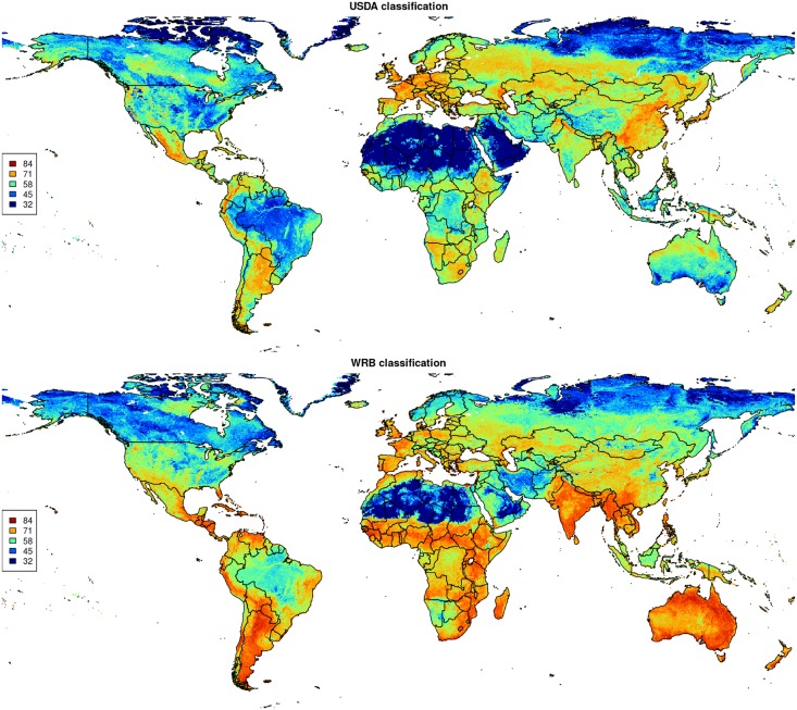
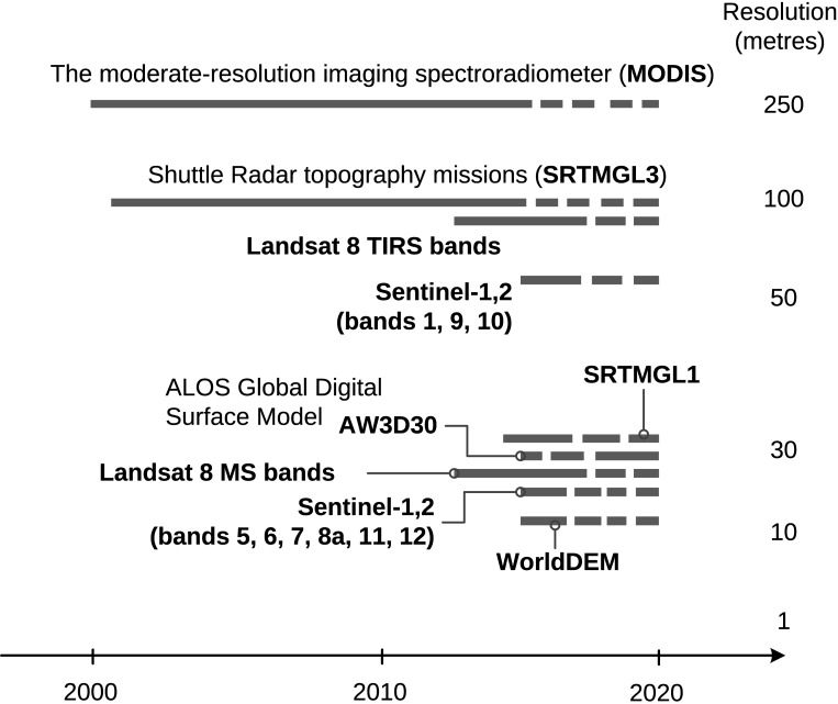
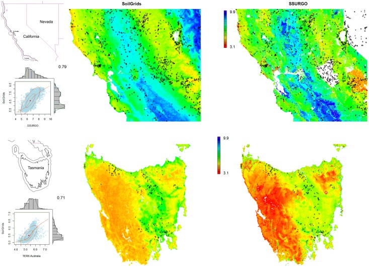
This paper describes the technical development and accuracy assessment of the most recent and improved version of the SoilGrids system at 250m resolution (June 2016 update). SoilGrids provides global predictions for standard numeric soil properties (organic carbon, bulk density, Cation Exchange Capacity (CEC), pH, soil texture fractions and coarse fragments) at seven standard depths (0, 5, 15, 30, 60, 100 and 200 cm), in addition to predictions of depth to bedrock and distribution of soil classes based on the World Reference Base (WRB) and USDA classification systems (ca. 280 raster layers in total). Predictions were based on ca. 150,000 soil profiles used for training and a stack of 158 remote sensing-based soil covariates (primarily derived from MODIS land products, SRTM DEM derivatives, climatic images and global landform and lithology maps), which were used to fit an ensemble of machine learning methods-random forest and gradient boosting and/or multinomial logistic regression-as implemented in the R packages ranger, xgboost, nnet and caret. The results of 10-fold cross-validation show that the ensemble models explain between 56% (coarse fragments) and 83% (pH) of variation with an overall average of 61%. Improvements in the relative accuracy considering the amount of variation explained, in comparison to the previous version of SoilGrids at 1 km spatial resolution, range from 60 to 230%. Improvements can be attributed to: (1) the use of machine learning instead of linear regression, (2) to considerable investments in preparing finer resolution covariate layers and (3) to insertion of additional soil profiles. Further development of SoilGrids could include refinement of methods to incorporate input uncertainties and derivation of posterior probability distributions (per pixel), and further automation of spatial modeling so that soil maps can be generated for potentially hundreds of soil variables. Another area of future research is the development of methods for multiscale merging of SoilGrids predictions with local and/or national gridded soil products (e.g. up to 50 m spatial resolution) so that increasingly more accurate, complete and consistent global soil information can be produced. SoilGrids are available under the Open Data Base License.
Overview
The claims and statistics of this paper haven’t been checked yet.
Free: it reads the open-access text and checks the first 5 claims that cite a source we can check. Create a free account to check every claim.
Integrity signals
Registry
Cites
Statistics
Figures






Verification
Claims the paper makes
The claims and statistics of this paper haven’t been checked yet.
Free: it reads the open-access text and checks the first 5 claims that cite a source we can check. Create a free account to check every claim.
Claims other papers make about this one
Each is checked against this paper’s own text: does it say what the citing paper says it does?
The source backs part of the claim, not all of it — or backs it for a different population, condition or comparison.
In the citing paper
“These uncertainties are mostly due to the uneven distribution and overall scarcity of field data for modelling and validating carbon stocks in the biomass and soil 27,64,65 .”
From Global priority areas for ecosystem restoration (2020) · cites this paper as [65]
Experimental — accuracy not yet measured
Self-check
Percentages, sums and reported differences re-computed from the paper’s own numbers.
The self-check needs the paper’s full text.
Citations
Cites
XGBoost: A Scalable Tree Boosting System
Chen, T., & Guestrin, C. (2016) · Proceedings of the 22nd ACM SIGKDD International Conference on Knowledge Discovery and Data Mining · doi:10.1145/2939672.2939785 · Cited by 54,569
Modern Applied Statistics with S
Venables, W. N., & Ripley, B. D. (2002) · Statistics and Computing · doi:10.1007/978-0-387-21706-2 · Cited by 24,305
Very high resolution interpolated climate surfaces for global land areas
Hijmans, R. J., Cameron, S. E., Parra, J. L., Jones, P. G., & Jarvis, A. (2005) · International Journal of Climatology · doi:10.1002/joc.1276 · Cited by 19,825
Total Carbon, Organic Carbon, and Organic Matter
Nelson, D. W., & Sommers, L. E. (1982) · Agronomy Monographs · doi:10.2134/agronmonogr9.2.2ed.c29 · Cited by 9,978
Building Predictive Models in R Using the caret Package
Kuhn, M. (2008) · Journal of Statistical Software · doi:10.18637/jss.v028.i05 · Cited by 8,863
Weighted kappa: nominal scale agreement provision for scaled disagreement or partial credit
Cohen, J. (1968) · Psychological Bulletin · doi:10.1037/h0026256 · Cited by 8,736
Kuhn, M., & Johnson, K. (2013) · doi:10.1007/978-1-4614-6849-3 · Cited by 6,788
Communication in the presence of noise
Shannon, C. E. (1949) · Proceedings of the IRE · doi:10.1109/jrproc.1949.232969 · Cited by 6,539
Anonim, A. (2010) · Cited by 4,945
Communication In The Presence Of Noise
Shannon, C. E. (1998) · Proceedings of the IEEE · doi:10.1109/jproc.1998.659497 · Cited by 4,804
Research works printed but not linked: 5
- D Arrouays, 2014, Soil carbon. vol. 125 of Advances in Agronomy, 93
- SA Lei, 1998, Soil Properties of the Kelso Sand Dunes in the Mojave Desert, The Southwestern Naturalist, 43, 47
- Huffman GJ, Bolvin DT. GPCP version 2 combined precipitation data set documentation. vol. 1. Laboratory for Atmospheres, NASA Goddard Space Flight Center and Science Systems and Applications; 2009.
- Kempen B. Updating soil information with digital soil mapping [PhD thesis]. Wageningen University. Wageningen; 2011. Available from: http://edepot.wur.nl/187198.
- Eberhardt E. Deriving WRB soil types using National German Soil Survey Guidelines. In: NCSS National Conference. NCSS Standards. Asheville, NC: United States Department of Agriculture USDA-NRCS; 2011. p. 1–2.
Cited by
Items 201–300 of 1,006
Elrys, A. S., Uwiragiye, Y., Zhang, Y., Abdel-Fattah, M. K., Chen, Z.-X., Zhang, H., Meng, L., Wang, J., Zhu, T., Cheng, Y., et al. (2022) · Nature Food · doi:10.1038/s43016-022-00657-x · Cited by 165
Denitrification in wetlands: A review towards a quantification at global scale
Martínez-Espinosa, C., Sauvage, S., Bitar, A. A., Green, P., Vörösmarty, C. J., & Sánchez-Pérez, J. M. (2020) · The Science of The Total Environment · doi:10.1016/j.scitotenv.2020.142398 · Cited by 174
Shen, L. Q., Amatulli, G., Sethi, T., Raymond, P. A., & Domisch, S. (2020) · Scientific Data · doi:10.1038/s41597-020-0478-7 · Cited by 170
Rates of niche and phenotype evolution lag behind diversification in a temperate radiation
Folk, R. A., Stubbs, R. L., Mort, M. E., Cellinese, N., Allen, J. M., Soltis, P. S., Soltis, D. E., & Guralnick, R. P. (2019) · Proceedings of the National Academy of Sciences · doi:10.1073/pnas.1817999116 · Cited by 159
Multilevel Deep Learning Network for County-Level Corn Yield Estimation in the U.S. Corn Belt
Sun, J., Lai, Z., Di, L., Sun, Z., Tao, J., & Shen, Y. (2020) · IEEE Journal of Selected Topics in Applied Earth Observations and Remote Sensing · doi:10.1109/jstars.2020.3019046 · Cited by 172
“The predictions were based on ca. 150 000 soil profiles used for training and a stack of 158 remote sensing-based soil covariates (primarily derived from MODIS land products, SRTM DEM derivatives, climatic images, and global landform and lithology maps) [39].”
MethodPoeplau, C., Jacobs, A., Don, A., Vos, C., Schneider, F., Wittnebel, M., Tiemeyer, B., Heidkamp, A., Prietz, R., & Flessa, H. (2020) · Journal of Plant Nutrition and Soil Science · doi:10.1002/jpln.202000113 · Cited by 173
“A harmonized methodological approach to assess SOC stocks is thus required (Hengl et al., 2017), as highlighted also by the FAO Global Soil Partnership (Pillar 5).”
MethodTemporal changes in global soil respiration since 1987
Lei, J., Guo, X. Y., Zeng, Y., Zhou, J. Z., Gao, Q., & Yang, Y. (2021) · Nature Communications · doi:10.1038/s41467-020-20616-z · Cited by 174
High fire frequency and the impact of the 2019–2020 megafires on Australian plant diversity
Gallagher, R. V., Allen, S. P., Mackenzie, B. D. E., Yates, C. J., Gosper, C. R., Keith, D. A., Merow, C., White, M., Wenk, E. H., Maitner, B., et al. (2021) · Diversity and Distributions · doi:10.1111/ddi.13265 · Cited by 164
“Climate and soil data were accessed from WorldClim2 (Fick & Hijmans, 2017), the Global Aridity and PET database (Trabucco & Zomer, 2018), CliMond (Kriticos et al., 2012) and the International Soil Reference and Information Centre (Hengl et al., 2017).”
MethodSentinel-1 soil moisture at 1 km resolution: a validation study
Balenzano, A., Mattia, F., Satalino, G., Lovergine, F., Palmisano, D., Peng, J. X., Marzahn, P., Wegmüller, U., Cartus, O., Dąbrowska‐Zielińska, K., et al. (2021) · Remote Sensing of Environment · doi:10.1016/j.rse.2021.112554 · Cited by 169
Wang, X., Ran, Y., Pang, G., Chen, D., Su, B., Chen, R., Li, X., Chen, H. W., Yang, M., Gou, X., et al. (2022) · Earth-Science Reviews · doi:10.1016/j.earscirev.2022.104042 · Cited by 158
Sims, N. C., England, J. R., Newnham, G. J., Alexander, S., Green, C., Minelli, S., & Held, A. A. (2018) · Environmental Science & Policy · doi:10.1016/j.envsci.2018.10.014 · Cited by 167
Towards mapping the diversity of canopy structure from space with GEDI
Schneider, F., Ferraz, A., Hancock, S., Duncanson, L. I., Dubayah, R., Pavlick, R., & SCHIMEL, D. S. (2020) · Environmental Research Letters · doi:10.1088/1748-9326/ab9e99 · Cited by 176
Trepel, J., le Roux, E., Abraham, A. J., Buitenwerf, R., Kamp, J., Kristensen, J. A., Tietje, M., Lundgren, E. J., & Svenning, J. (2024) · Nature Ecology & Evolution · doi:10.1038/s41559-024-02327-6 · Cited by 189
“74,75,76,77), which may have caused a scale mismatch and thus influenced effect size and significance.”
Leenaars, J. G. B., Claessens, L., Heuvelink, G. B. M., Hengl, T., González, M. R., van Bussel, L. G. J., Guilpart, N., Yang, H. S., & Cassman, K. G. (2018) · Geoderma · doi:10.1016/j.geoderma.2018.02.046 · Cited by 162
Self-citationHe, X., Wang, D., Jiang, Y., Li, M., Delgado‐Baquerizo, M., McLaughlin, C. M., Marcon, C., Guo, L., Baer, M., Moya, Y. A. T., et al. (2024) · Nature Plants · doi:10.1038/s41477-024-01654-7 · Cited by 168
“Data were collected from WorldClim 47 , the NCEP/NCAR reanalysis project (https://psl.noaa.gov/data/reanalysis/ reanalysis.shtml) 48 , NASA SRB (https://asdc.larc.nasa.gov/project/ SRB), Climate Research Unit 49 , SoilGrids 50 and the Global Soil Data-set 51 .”
Soil bacterial diversity mediated by microscale aqueous-phase processes across biomes
Bickel, S., & Or, D. (2020) · Nature Communications · doi:10.1038/s41467-019-13966-w · Cited by 150
Global assessment of mountain ecosystem services using earth observation data
Grêt‐Regamey, A., & Weibel, B. (2020) · Ecosystem Services · doi:10.1016/j.ecoser.2020.101213 · Cited by 164
Global relationships in tree functional traits
Maynard, D. S., Bialic‐Murphy, L., Zohner, C. M., Averill, C., van den Hoogen, J., Ma, H., Mo, L., Smith, G. R., Acosta, A. T. R., Aubin, I., et al. (2022) · Nature Communications · doi:10.1038/s41467-022-30888-2 · Cited by 181
Are Terrestrial Biosphere Models Fit for Simulating the Global Land Carbon Sink?
Seiler, C., Melton, J. R., Arora, V. K., Sitch, S. A., Friedlingstein, P., Arneth, A., Goll, D. S., Jain, A. K., Joetzjer, É., Lienert, S., et al. (2022) · Journal of Advances in Modeling Earth Systems · doi:10.1029/2021ms002946 · Cited by 162
“Reference data for soil organic carbon in the top 100 cm were obtained from the Harmonized World Soil Database (HWSD) (Wieder, 2014) and from SoilGrids250m (SG250m) (Hengl et al., 2017).”
MethodGonzález‐Roglich, M., Zvoleff, A., Noon, M. L., Liniger, H., Fleiner, R., Harari, N., & García, C. L. (2018) · Environmental Science & Policy · doi:10.1016/j.envsci.2018.12.019 · Cited by 158
Dembélé, M., Schaefli, B., van de Giesen, N., & Mariethoz, G. (2020) · Hydrology and earth system sciences · doi:10.5194/hess-24-5379-2020 · Cited by 153
Adaptation and coordinated evolution of plant hydraulic traits
Sanchez‐Martinez, P., Martínez‐Vilalta, J., Dexter, K. G., Segovia, R. A., & Mencuccini, M. (2020) · Ecology Letters · doi:10.1111/ele.13584 · Cited by 160
Estimating crop biomass using leaf area index derived from Landsat 8 and Sentinel-2 data
Dong, T., Liu, J., Qian, B., He, L., Liu, J. J., Wang, R., Jing, Q., Champagne, C. M., McNairn, H. E., Powers, J., et al. (2020) · ISPRS Journal of Photogrammetry and Remote Sensing · doi:10.1016/j.isprsjprs.2020.08.003 · Cited by 156
Gao, D., Bai, E., Wang, S., Zong, S., Liu, Z., Fan, X., Zhao, C., & Hagedorn, F. (2022) · Global Change Biology · doi:10.1111/gcb.16374 · Cited by 157
Soil variability and quantification based on Sentinel-2 and Landsat-8 bare soil images: A comparison
Silvero, N. E. Q., Demattê, J. A. M., Amorim, M. T. A., dos Santos, N. V., Rizzo, R., Safanelli, J. L., Poppiel, R. R., Mendes, W. D. S., & Bonfatti, B. R. (2020) · Remote Sensing of Environment · doi:10.1016/j.rse.2020.112117 · Cited by 159
Expected global suitability of coffee, cashew and avocado due to climate change
Grüter, R., Trachsel, T., Laube, P., & Jaisli, I. (2022) · PLoS ONE · doi:10.1371/journal.pone.0261976 · Cited by 125
Soil Moisture from Fusion of Scatterometer and SAR: Closing the Scale Gap with Temporal Filtering
Bauer-Marschallinger, B., Paulik, C., Hochstöger, S., Mistelbauer, T., Modanesi, S., Ciabatta, L., Massari, C., Brocca, L., & Wagner, W. (2018) · Remote Sensing · doi:10.3390/rs10071030 · Cited by 160
“Figure 5d adds the porosity of the soil layer at 0–5 cm depth from ISRIC SoilGrids [63] to the comparison.”
BackgroundSelf-citationPermafrost degradation increases risk and large future costs of infrastructure on the Third Pole
Ran, Y., Cheng, G., Dong, Y., Hjort, J., Lovecraft, A. L., Kang, S., Tan, M., & Li, X. (2022) · Communications Earth & Environment · doi:10.1038/s43247-022-00568-6 · Cited by 145
Globally invariant metabolism but density-diversity mismatch in springtails
Potapov, A., Guerra, C. A., van den Hoogen, J., Бабенко, А. Б., Bellini, B. C., Berg, M. P., Chown, S. L., Deharveng, L., Kováč, Ľ., Kuznetsova, N. A., et al. (2023) · Nature Communications · doi:10.1038/s41467-023-36216-6 · Cited by 167
Qu, L., Chen, Z., Li, M., Zhi, J., & Wang, H. (2021) · Remote Sensing · doi:10.3390/rs13030453 · Cited by 162
“[47], we utilized the numerical integration to average the soil features of the topsoil (0–15 cm) and subsoil (15–60 cm).”
MethodGerber, J., Ray, D. K., Makowski, D., Butler, E. E., Mueller, N. D., West, P. C., Johnson, J. A., Polasky, S., Samberg, L., Siebert, S., et al. (2024) · Nature Food · doi:10.1038/s43016-023-00913-8 · Cited by 172
“We obtained 30 arcsec grids of available water capacity, pH (PH) and soil organic carbon at various soil depths from the SoilGrid-s1km project 65,66 (downloaded from www.isric.org on 27 June 2017).”
Science-based decision support for formulating crop fertilizer recommendations in sub-Saharan Africa
Rurinda, J., Zingore, S., Jibrin, J. M., Balemi, T., Masuki, K., Andersson, J., Pampolino, M. F., Mohammed, I., Mutegi, J., Kamara, A. Y., et al. (2020) · Agricultural Systems · doi:10.1016/j.agsy.2020.102790 · Cited by 165
Bare Earth’s Surface Spectra as a Proxy for Soil Resource Monitoring
Demattê, J. A. M., Safanelli, J. L., Poppiel, R. R., Rizzo, R., Silvero, N. E. Q., Mendes, W. D. S., Bonfatti, B. R., Dotto, A. C., Salazar, D. F. U., Mello, F. A. D. O., et al. (2020) · Scientific Reports · doi:10.1038/s41598-020-61408-1 · Cited by 165
Future global streamflow declines are probably more severe than previously estimated
Zhang, Y., Zheng, H., Zhang, X., Leung, L.-Y. R., Liu, C., Zheng, C., Guo, Y., Chiew, F. H. S., Post, D. A., Kong, D., et al. (2023) · Nature Water · doi:10.1038/s44221-023-00030-7 · Cited by 158
Necromass-derived soil organic carbon and its drivers at the global scale
Cao, Y., Ding, J., Li, J., Xin, Z., Ren, S., & Wang, T. (2023) · Soil Biology and Biochemistry · doi:10.1016/j.soilbio.2023.109025 · Cited by 153
Dembélé, M., Ceperley, N., Zwart, S. J., Salvadore, E., Mariethoz, G., & Schaefli, B. (2020) · Advances in Water Resources · doi:10.1016/j.advwatres.2020.103667 · Cited by 148
Breinl, K., Lun, D., Müller‐Thomy, H., & Blöschl, G. (2021) · Journal of Hydrology · doi:10.1016/j.jhydrol.2021.126759 · Cited by 159
Controls of soil organic matter on soil thermal dynamics in the northern high latitudes
Zhu, D., Ciais, P., Krinner, G., Maignan, F., Jornet‐Puig, A., & Hugelius, G. (2019) · Nature Communications · doi:10.1038/s41467-019-11103-1 · Cited by 152
Functional Redundancy in Soil Microbial Community Based on Metagenomics Across the Globe
Chen, H., Ma, K., Lu, C., Fu, Q., Qiu, Y., Zhao, J., Huang, Y., Yang, Y., Schadt, C. W., & Chen, H. (2022) · Frontiers in Microbiology · doi:10.3389/fmicb.2022.878978 · Cited by 162
Species distribution modelling tools and databases to assist managing forests under climate change
Booth, T. H. (2018) · Forest Ecology and Management · doi:10.1016/j.foreco.2018.08.019 · Cited by 152
Longo, M., Knox, R., Medvigy, D., Levine, N. M., Dietze, M. C., Kim, Y., Swann, A. L. S., Zhang, K., Rollinson, C. R., Bras, R. L., et al. (2019) · Geoscientific model development · doi:10.5194/gmd-12-4309-2019 · Cited by 154
Landscape changes and their hydrologic effects: Interactions and feedbacks across scales
Stephens, C. M., Lall, U., Johnson, F. M., & Marshall, L. A. (2020) · Earth-Science Reviews · doi:10.1016/j.earscirev.2020.103466 · Cited by 154
Emergent temperature sensitivity of soil organic carbon driven by mineral associations
Georgiou, K., Koven, C. D., Wieder, W. R., Hartman, M. D., Riley, W. J., Pett‐Ridge, J., Bouskill, N., Abramoff, R., Slessarev, E. W., Ahlström, A., et al. (2024) · Nature Geoscience · doi:10.1038/s41561-024-01384-7 · Cited by 156
“Following Shi et al. 41 , soil organic C stocks to 1 m depth were estimated as the mean of Harmonized World Soil Database 59 and SoilGrids 60 maps to reflect a best estimate and uncertainty across data products.”
Influence of climate, soil, and land cover on plant species distribution in the European Alps
Chauvier, Y., Thuiller, W., Brun, P., Lavergne, S., Descombes, P., Karger, D. N., Renaud, J., & Zimmermann, N. E. (2020) · Ecological Monographs · doi:10.1002/ecm.1433 · Cited by 147
Giuliani, G., Rosina, M., & Reggio, A. (2021) · FEBS Journal · doi:10.1111/febs.16080 · Cited by 159
COSMOS-Europe: a European network of cosmic-ray neutron soil moisture sensors
Bogena, H., Schrön, M., Jakobi, J. C., Ney, P., Zacharias, S., Andreasen, M., Baatz, R., Boorman, D. B., Duygu, M. B., Eguibar, M. Á., et al. (2022) · Earth system science data · doi:10.5194/essd-14-1125-2022 · Cited by 152
Catchment properties and the photosynthetic trait composition of freshwater plant communities
Iversen, L. L., Winkel, A., Baastrup‐Spohr, L., Hinke, A. B., Alahuhta, J., Baattrup‐Pedersen, A., Birk, S., Brodersen, P., Chambers, P. A., Ecke, F., et al. (2019) · Science · doi:10.1126/science.aay5945 · Cited by 142
Agroecology-based soil erosion assessment for better conservation planning in Ethiopian river basins
Fenta, A. A., Tsunekawa, A., Haregeweyn, N., Tsubo, M., Yasuda, H., Kawai, T., Ebabu, K., Berihun, M. L., Belay, A. S., & Sultan, D. (2021) · Environmental Research · doi:10.1016/j.envres.2021.110786 · Cited by 140
Origins of global mountain plant biodiversity: Testing the ‘mountain‐geobiodiversity hypothesis’
Muellner-Riehl, A. N., Schnitzler, J., Kissling, W. D., Mosbrugger, V., Rijsdijk, K. F., Seijmonsbergen, A. C., Versteegh, H., & Favre, A. (2019) · Journal of Biogeography · doi:10.1111/jbi.13715 · Cited by 145
“We de‐ rived a soil index for each grid cell based on the number of soil types from the SoilGrids repository (Hengl et al., 2017) which is based on the World Reference Base for Soils system (IUSS Working Group WRB, 2015).”
MethodsPlotOpen – An environmentally balanced, open‐access, global dataset of vegetation plots
Sabatini, F. M., Lenoir, J., Hattab, T., Arnst, E., Chytrý, M., Dengler, J., de Ruffray, P., Hennekens, S. M., Jandt, U., Jansen, F., et al. (2021) · Global Ecology and Biogeography · doi:10.1111/geb.13346 · Cited by 160
Fan, X., Gao, D., Zhao, C., Wang, C., Qu, Y., Zhang, J., & Bai, E. (2021) · The ISME Journal · doi:10.1038/s41396-021-00914-0 · Cited by 143
Li, B., Ryu, Y., Jiang, C., Dechant, B., Liu, J., Yan, Y., & Li, X. (2023) · Remote Sensing of Environment · doi:10.1016/j.rse.2023.113696 · Cited by 147
Wang, F., Yang, S., Wei, Y., Shi, Q., & Ding, J. (2020) · The Science of The Total Environment · doi:10.1016/j.scitotenv.2020.142030 · Cited by 145
Söthe, C., Gonsamo, A., Arabian, J., & Snider, J. (2021) · Geoderma · doi:10.1016/j.geoderma.2021.115402 · Cited by 146
van den Bout, B., Lombardo, L., van Westen, C. J., & Jetten, V. G. (2018) · Environmental Modelling & Software · doi:10.1016/j.envsoft.2018.03.017 · Cited by 133
Sensitivity of global soil carbon stocks to combined nutrient enrichment
Crowther, T. W., Riggs, C., Lind, E. M., Borer, E. T., Seabloom, E. W., Hobbie, S. E., Wubs, E. R. J., Adler, P. B., Firn, J. L., Gherardi, L., et al. (2019) · Ecology Letters · doi:10.1111/ele.13258 · Cited by 143
“…these linear models across the Northern Hemisphere (where the vast majority of our data originate from), using global models of soil texture, carbon content (Hengl et al. 2017) and precipitation (Fick & Hijmans 2017), we are able to visualize the general trends in these relationships across space.”
BackgroundThe environmental consequences of climate-driven agricultural frontiers
Hannah, L., Roehrdanz, P. R., Krishna Bahadur, K. C., Fraser, E., Donatti, C. I., Sáenz, L., Wright, T. M., Hijmans, R. J., Mulligan, M. P., van den Berg, A. A., et al. (2020) · PLoS ONE · doi:10.1371/journal.pone.0228305 · Cited by 156
“To account for soil organic carbon stocks in agricultural frontiers, we obtained a gridded global dataset of estimated soil organic carbon (tonnes ha) in the top 100 cm [35].”
MethodThe global distribution of plants used by humans
Pironon, S., Ondo, I., Diazgranados, M., Allkinꝉ, R., Baquero, A. C., Cámara‐Leret, R., Canteiro, C., Dennehy-Carr, Z., Govaerts, R., Hargreaves, S., et al. (2024) · Science · doi:10.1126/science.adg8028 · Cited by 149
Hurskainen, P., Adhikari, H., Siljander, M., Pellikka, P., & Hemp, A. (2019) · Remote Sensing of Environment · doi:10.1016/j.rse.2019.111354 · Cited by 141
Climatic limit for agriculture in Brazil
Rattis, L., Brando, P. M., Macedo, M. N., Spera, S. A., Castanho, A. D. D. A., Marques, E. Q., Costa, N. D. Q., Silvério, D. V., & Coe, M. T. (2021) · Nature Climate Change · doi:10.1038/s41558-021-01214-3 · Cited by 182
Zhang, L., Cai, Y., Huang, H., Li, A., Yang, L., & Zhou, C. (2022) · Remote Sensing · doi:10.3390/rs14184441 · Cited by 142
World reference base for soil resources (WRB)
Mantel, S., Dondeyne, S., & Deckers, S. (2023) · Elsevier eBooks · doi:10.1016/b978-0-12-822974-3.00161-0 · Cited by 131
Self-citationTziachris, P., Aschonitis, V. G., Chatzistathis, T., & Papadopoulou, M. P. (2018) · CATENA · doi:10.1016/j.catena.2018.11.010 · Cited by 132
Soil moisture content retrieval from Landsat 8 data using ensemble learning
Zhang, Y., Liang, S., Zhu, Z., Ma, H., & He, T. (2022) · ISPRS Journal of Photogrammetry and Remote Sensing · doi:10.1016/j.isprsjprs.2022.01.005 · Cited by 136
A China dataset of soil properties for land surface modelling (version 2, CSDLv2)
Shi, G., Sun, W., Shangguan, W., Wei, Z., Yuan, H., Lü, L., Sun, X., Zhang, Y., Liang, H., Li, D., et al. (2025) · Earth system science data · doi:10.5194/essd-17-517-2025 · Cited by 158
Self-citationLoche, M., Alvioli, M., Marchesini, I., Bakka, H. C., & Lombardo, L. (2022) · Earth-Science Reviews · doi:10.1016/j.earscirev.2022.104125 · Cited by 141
Global potential for natural regeneration in deforested tropical regions
Williams, B. A., Beyer, H. L., Fagan, M. E., Chazdon, R. L., Schmoeller, M., Sprenkle-Hyppolite, S., Griscom, B. W., Watson, J. E. M., Tedesco, A. M., González‐Roglich, M., et al. (2024) · Nature · doi:10.1038/s41586-024-08106-4 · Cited by 162
“Thus, 12 soil properties mapped at a 250-m resolution 74 were evaluated for use in the modelling, including: (1) total profile depth (cm); (2) plant exploitable (effective) soil depth (cm); (3) organic carbon (g per kg); (4) pH (×10); (5) sand (g per kg); (6) silt (g per kg); (7) clay (g per kg);…”
Landmeyer, N. C., Bürkner, P., Wiendl, H., Ruck, T., Hartung, H., Holling, H., Meuth, S. G., & Johnen, A. (2020) · Neurology · doi:10.1212/wnl.0000000000009522 · Cited by 135
Exploring Machine Learning Models for Soil Nutrient Properties Prediction: A Systematic Review
Folorunso, O. O., Ojo, O. E., Busari, M. A., Adebayo, M., Joshua, A., Folorunso, D. A., Ugwunna, C. O., Olabanjo, O., & Olabanjo, O. A. (2023) · Big Data and Cognitive Computing · doi:10.3390/bdcc7020113 · Cited by 149
“Soil organic carbon (g kg1), soil pH, sand, silt, and clay fractions (%), bulk density (kg m3), cation-exchange capacity (cmol+/kg), coarse fragments (%), soil organic carbon stock (t ha1), and depth to bedrock are just a few of the local soil properties that [93] takes into account using tree-based models (random for…”
BackgroundAqueduct 4.0: Updated Decision-Relevant Global Water Risk Indicators
Kuzma, S., Bierkens, M. F. P., Lakshman, S., Luo, T., Saccoccia, L., Sutanudjaja, E. H., & van Beek, R. (2023) · doi:10.46830/writn.23.00061 · Cited by 187
“SoilGrids250 was used to replace the Digital Soil Map of the World (Nachtergaele et al. 2009) because of its finer resolution.”
MethodA global atlas of soil viruses reveals unexplored biodiversity and potential biogeochemical impacts
Graham, E. B., Camargo, A. P., Wu, R., NECHES, R. Y., Nolan, M., Páez-Espino, D., Kyrpides, N. C., Jansson, J. K., McDermott, J., Hofmockel, K., et al. (2024) · Nature Microbiology · doi:10.1038/s41564-024-01686-x · Cited by 156
“33).”
Anees, S. A., Mehmood, K., Khan, W. R., Sajjad, M. U., Alahmadi, T. A., Alharbi, S. A., & Luo, M. (2024) · Ecological Informatics · doi:10.1016/j.ecoinf.2024.102732 · Cited by 135
Radočaj, D., Jurišić, M., & Gašparović, M. (2022) · Remote Sensing · doi:10.3390/rs14030778 · Cited by 150
“SOC, pH, sand, silt, clay, bulk density, CEC, coarse fragments random forest, gradient boosting, neural networks MODIS SRTM [66]”
MethodOr, D., & Lehmann, P. (2019) · Water Resources Research · doi:10.1029/2018wr024050 · Cited by 128
“The hydraulic properties (represented by the van Genuchten parameters: n, α, θres, θsat, and Ks) were computed using the pedotransfer functions of Tóth et al. (2015) and soil textural information from the SoilGrids database (Hengl et al., 2017) available at a resolution of 0.25 km.”
MethodInfluentialA note on knowledge discovery and machine learning in digital soil mapping
Wadoux, A. M. J. ‐., Samuel‐Rosa, A., Poggio, L., & Mulder, V. L. (2019) · European Journal of Soil Science · doi:10.1111/ejss.12909 · Cited by 124
“The first PCs of all pictures were geo-referenced, cropped to the extent of the Pangaea and resampled to match the resolution of the SoilGrids tile.”
BackgroundMethodMonitoring changes in global soil organic carbon stocks from space
Padarian, J., Stockmann, U., Minasny, B., & McBratney, A. B. (2022) · Remote Sensing of Environment · doi:10.1016/j.rse.2022.113260 · Cited by 139
Quantifying direct yield benefits of soil carbon increases from cover cropping
Vendig, I., Guzman, A., Cerda, G. D. L., Esquivel, K., Mayer, A. C., Ponisio, L. C., & Bowles, T. M. (2023) · Nature Sustainability · doi:10.1038/s41893-023-01131-7 · Cited by 145
Historical impacts of grazing on carbon stocks and climate mitigation opportunities
Ren, S., Terrer, C., Li, J., Cao, Y., Yang, S., & Liu, D. (2024) · Nature Climate Change · doi:10.1038/s41558-024-01957-9 · Cited by 151
Digital soil mapping across the globe
Arrouays, D., Lagacherie, P., & Hartemink, A. E. (2017) · Geoderma Regional · doi:10.1016/j.geodrs.2017.03.002 · Cited by 123
Blanco, C. M. G., Gómez, V. M. B., Crespo, P., & Ließ, M. (2017) · Geoderma · doi:10.1016/j.geoderma.2017.12.002 · Cited by 134
“A similar pattern of residuals is reported in other studies concerning the regionalization of soil properties with random forest (Hengl et al., 2017; Mulder et al., 2016; Shangguan et al., 2016; Xu et al., 2016) and has been attributed to small datasets and underrepresented values of the target…”
MethodResultGebremicael, T. G., Mohamed, Y. A., & van der Zaag, P. (2019) · The Science of The Total Environment · doi:10.1016/j.scitotenv.2019.01.085 · Cited by 127
“The initial soil map, available online from the International Soil Reference and Information Centre (ISRIC) SoilsGrid250 (Hengl et al., 2017), was modified based on the study area characteristics.”
MethodSatellite data integration for soil clay content modelling at a national scale
Loiseau, T., Chen, S., Mulder, V. L., Dobarco, M. R., Richer-De-Forges, A. C., Lehmann, S., Bourennane, H., Saby, N., Martin, M. P., Vaudour, E., et al. (2019) · International Journal of Applied Earth Observation and Geoinformation · doi:10.1016/j.jag.2019.101905 · Cited by 137
Spatial Patterns and Drivers of Nonperennial Flow Regimes in the Contiguous United States
Hammond, J. C., Zimmer, M. A., Shanafield, M. A., Kaiser, K. E., Godsey, S. E., Mims, M. C., Zipper, S. C., Burrows, R. M., Kampf, S. K., Dodds, W. K., et al. (2021) · Geophysical Research Letters · doi:10.1029/2020gl090794 · Cited by 133
“Physiographic characteristics included drainage area and watershed mean values of elevation, slope, permeability, soil available water capacity, topographic wetness index, depth to bedrock, porosity, and total subsurface storage (Falcone, 2011; Gleeson et al., 2014; Hengl et al., 2017).”
BackgroundTowards a global synthesis of Collembola knowledge – challenges and potential solutions
Potapov, A., Bellini, B. C., Chown, S. L., Deharveng, L., Janssens, F., Kováč, Ľ., Kuznetsova, N. A., Ponge, J., Potapov, M. B., Querner, P., et al. (2020) · Soil Organisms · doi:10.25674/so92iss3pp161 · Cited by 175
Venter, Z. S., Hawkins, H., Cramer, M. D., & Mills, A. (2021) · The Science of The Total Environment · doi:10.1016/j.scitotenv.2021.145384 · Cited by 137
Farm vehicles approaching weights of sauropods exceed safe mechanical limits for soil functioning
Keller, T., & Or, D. (2022) · Proceedings of the National Academy of Sciences · doi:10.1073/pnas.2117699119 · Cited by 137
Trends and Challenges in Irrigation Scheduling in the Semi-Arid Area of Spain
García, I. F., Lecina, S., Ruiz-Sánchez, M. C., Vera, J., Conejero, W., Conesa, M. R., Domínguez, A., Pardo, J. J. S., Lellis, B., & Montesinos, P. (2020) · Water · doi:10.3390/w12030785 · Cited by 127
“Standard numerical soil properties at a spatial resolution of 250 m and at a global scale can be obtained from systems such as SoilGridsTM [55].”
MethodSilva, A. C., & de Souza, A. F. (2018) · PLoS ONE · doi:10.1371/journal.pone.0196130 · Cited by 151
Global hydro-environmental lake characteristics at high spatial resolution
Lehner, B., Messager, M., Korver, M. C., & Linke, S. (2022) · Scientific Data · doi:10.1038/s41597-022-01425-z · Cited by 135
Evaluation of Soil Thermal Conductivity Schemes for Use in Land Surface Modeling
Dai, Y., Wei, N., Yuan, H., Zhang, S., Shangguan, W., Liu, S., Lu, X., & Xin, Y. (2019) · Journal of Advances in Modeling Earth Systems · doi:10.1029/2019ms001723 · Cited by 127
“The Johansen [1975] scheme and Côté and Konrad [2005] scheme also provide satisfactory estimates, whose biases are 0.”
BackgroundMethodSelf-citationVelazco, S. J. E., Ribeiro, B. R., Laureto, L. M. O., & Júnior, P. D. M. (2020) · Biological Conservation · doi:10.1016/j.biocon.2020.108822 · Cited by 137
Annual precipitation explains variability in dryland vegetation greenness globally but not locally
Ukkola, A., Kauwe, M. G. D., Roderick, M. L., Burrell, A. L., Lehmann, P., & Pitman, A. J. (2021) · Global Change Biology · doi:10.1111/gcb.15729 · Cited by 124
The Influence of Topography on the Global Terrestrial Water Cycle
Gnann, S. J., Baldwin, J. W., Cuthbert, M. O., Gleeson, T., Schwanghart, W., & Wagener, T. (2025) · Reviews of Geophysics · doi:10.1029/2023rg000810 · Cited by 138
“Hengl et al. (2017) produced global soil maps (e.g., including soil texture) using an ensemble of machine learning methods, which also include topographic attributes and landforms as predictor variables.”
A Global Database of Soil Plant Available Phosphorus
McDowell, R. W., Noble, A. D. L., Pletnyakov, P., & Haygarth, P. M. (2023) · Scientific Data · doi:10.1038/s41597-023-02022-4 · Cited by 141
Leveraging Modern Artificial Intelligence for Remote Sensing and NWP: Benefits and Challenges
Boukabara, S., Krasnopolsky, V. M., Stewart, J. Q., Maddy, E. S., Shahroudi, N., & Hoffman, R. N. (2019) · Bulletin of the American Meteorological Society · doi:10.1175/bams-d-18-0324.1 · Cited by 126
Taghizadeh‐Mehrjardi, R., Mahdianpari, M., Mohammadimanesh, F., Behrens, T., Toomanian, N., Scholten, T., & Schmidt, K. (2020) · Geoderma · doi:10.1016/j.geoderma.2020.114552 · Cited by 124
A global database of soil nematode abundance and functional group composition
van den Hoogen, J., Geisen, S., Wall, D. H., Wardle, D. A., Traunspurger, W., de Goede, R. G. M., Adams, B. J., Ahmad, W., Ferris, H., Bardgett, R. D., et al. (2020) · Scientific Data · doi:10.1038/s41597-020-0437-3 · Cited by 117
“In short, information about soil texture and physiochemical properties was obtained from SoilGrids 18 , limited to the upper soil layer (top 15 cm).”
Critical Soil Moisture Derived From Satellite Observations Over Europe
Denissen, J., Teuling, A. J., Reichstein, M., & Orth, R. (2020) · Journal of Geophysical Research Atmospheres · doi:10.1029/2019jd031672 · Cited by 116
“…scale, moving average lines based on subselections of data representing particular soil, climate, and vegetation types are shown in Figure 3: (a) soil types have been determined using depth‐weighted average soil texture fractions of the top meter from the SoilGrids data set (Hengl et al., 2017).”
MethodThe role of soil in the contribution of food and feed
Silver, W. L., Pérez, T., Mayer, A. C., & Jones, A. R. (2021) · Philosophical Transactions of the Royal Society B Biological Sciences · doi:10.1098/rstb.2020.0181 · Cited by 141
Native diversity buffers against severity of non-native tree invasions
Delavaux, C. S., Crowther, T. W., Zohner, C. M., Robmann, N. M., Lauber, T., van den Hoogen, J., Kuebbing, S. E., Liang, J., de‐Miguel, S., Nabuurs, G. J., et al. (2023) · Nature · doi:10.1038/s41586-023-06440-7 · Cited by 136
Metadata
- Authors
- Hengl, T., Mendes de Jesus, J., Heuvelink, G. B. M., Ruiperez Gonzalez, M., Kilibarda, M., Blagotić, A., Shangguan, W., Wright, M. N., Geng, X., Bauer-Marschallinger, B., Guevara, M. A., Vargas, R., MacMillan, R. A., Batjes, N. H., Leenaars, J. G. B., Ribeiro, E., Wheeler, I., Mantel, S., & Kempen, B.
- Affiliations
- ISRIC - World Soil Information (NL)
- University of Belgrade (RS)
- Sun Yat-sen University (CN)
- University of Lübeck (DE)
- Agriculture and Agri-Food Canada (CA)
- TU Wien (AT)
- University of Delaware (US)
- ORCID
- Venue
- PLOS ONE
- Publisher
- Public Library of Science (PLoS)
- Published
- 2017-02-16
- Volume
- 12
- Issue
- 2
- Pages
- e0169748
- ISSN
- 1932-6203 (ISSN-L)
- PMC
- PMC5313206
- OpenAlex
- W2588003345
- Cited by
- 4,733
- References
- 89
- Citations by year
- 2026: 591 · 2025: 654 · 2024: 610 · 2023: 634 · 2022: 669 · 2021: 672 · 2020: 402 · 2019: 265 · 2018: 173 · 2017: 56
- FWCI
- 137.14
- Type
- journal article
- Language
- en
- Open access
- gold
- doi.org
- Licence
- Locations
- PLoS ONE (publishedVersion, cc-by)
- PubMed Central (publishedVersion, cc-by)
- PubMed (publishedVersion)
- RePEc: Research Papers in Economics (submittedVersion)
- DOAJ (DOAJ: Directory of Open Access Journals) (submittedVersion)
- GraFar (University of Belgrade, Faculty of Civil Engineering) (submittedVersion, cc-by)
- Socio-Environmental Systems Modeling (submittedVersion, cc-by)
- Data Archiving and Networked Services (DANS) (submittedVersion, other-oa)
- Topics
- Life Sciences › Agricultural and Biological Sciences › Soil Science › Soil Geostatistics and Mapping
- Physical Sciences › Environmental Science › Environmental Engineering › Soil Moisture and Remote Sensing
- Physical Sciences › Environmental Science › Management, Monitoring, Policy and Law › Soil and Land Suitability Analysis
- Keywords
- SoilGrids, soil properties, soil organic carbon, soil bulk density, cation exchange capacity, soil pH, soil texture, coarse fragments, bedrock depth, soil classification, USDA soil classification, MODIS, random forest, gradient boosting, multinomial logistic regression, ensemble learning, accuracy assessment, soil mapping
- MeSH terms
- Machine Learning, Algorithms, Conservation of Natural Resources, Environmental Monitoring, Humans, Models, Theoretical, Soil, Geographic Information Systems
About these checks
Registry, retraction, Cites and statistics results are computed, not judged, with one exception: a printed reference that no index lists is read once by a model before it counts as a citation error. Claims are extracted by a model and kept only when their quote appears verbatim in the text; each cited source is then checked, with a model’s help, for whether it says what the claim relies on. Those verdicts can be wrong — read the claim’s quote and the cited source before relying on one.
Statistics and arithmetic are recomputed, not judged.
Confidence bands are shown only for fields calibrated on our annotated test set. None is calibrated yet, so no band is shown.
What counts as a claim ›How we measure confidence ›How we check this ›
Are you an author, or do you see a problem with this page? Request a review
Data sources
Bibliographic data: Semantic Scholar, OpenAlex, Crossref.
Contains information from the Semantic Scholar Academic Graph Datasets, made available under the ODC Attribution License (ODC-BY 1.0).
Semantic Scholar’s data is described in: Kinney, R., et al. (2023). The Semantic Scholar Open Data Platform. arXiv:2301.10140.
