

The DOI matches its Crossref record; 161 of the 162 references it cites were found in a registry or an index; 5 of the 101 sources its claims cite were checked for support.
Perspectives in machine learning for wildlife conservation
Open accessAbstract
Inexpensive and accessible sensors are accelerating data acquisition in animal ecology. These technologies hold great potential for large-scale ecological understanding, but are limited by current processing approaches which inefficiently distill data into relevant information. We argue that animal ecologists can capitalize on large datasets generated by modern sensors by combining machine learning approaches with domain knowledge. Incorporating machine learning into ecological workflows could improve inputs for ecological models and lead to integrated hybrid modeling tools. This approach will require close interdisciplinary collaboration to ensure the quality of novel approaches and train a new generation of data scientists in ecology and conservation.
Overview
AI snapshot
Written from the paper’s full text.
TL;DR
This Perspective argues that animal ecology and conservation can exploit modern sensor data by integrating machine learning with ecological domain knowledge, rather than applying off-the-shelf ML. It reviews success stories across detection, re-identification, pose estimation, environmental reconstruction, and biodiversity modeling, and outlines attention points for responsible, interdisciplinary use.
Key findings
- Sensor expansion creates a data deluge: Agouti hosted 31 million images in August 2021 with only 1.5 million annotated, while Wildlife Insights was automatically processing 17 million camera trap images in August 2021; ML analysis cost reductions are estimated between 2 and 10×.
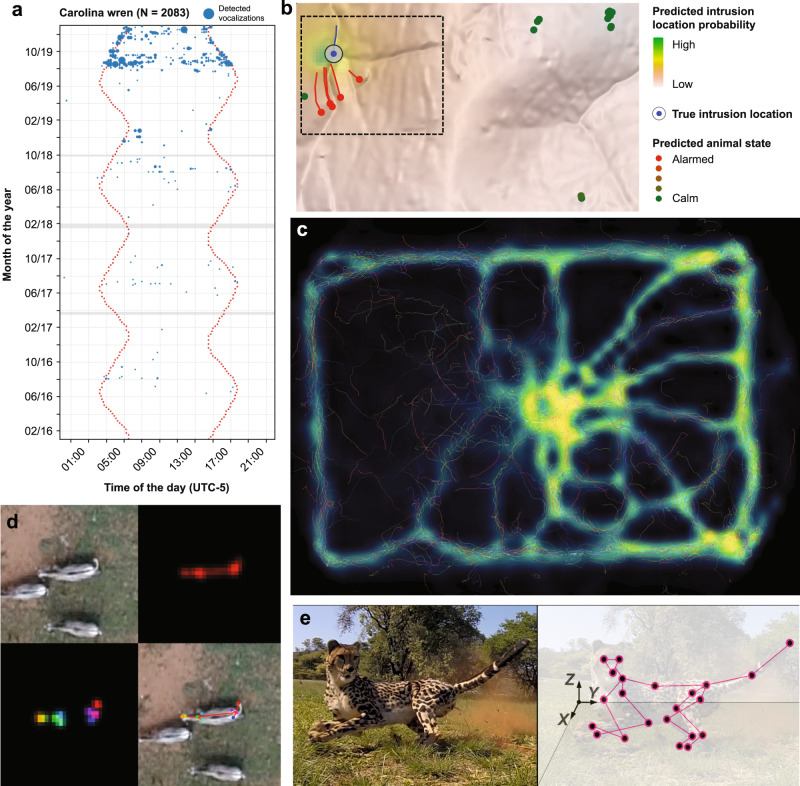
- ML/DL improve detection and identification: large mammal detection in Kuzikus improved from 20% to 80% recall at 75% precision; chimpanzee face recognition on 23 individuals and 1 million images achieved >90% accuracy (DL 84% vs. human novices 20% and experts 42%); tiger re-identification exceeded 90% across 92 tigers and 8,000 video clips.
- Domain-informed/hybrid models improve performance: Context R-CNN increased mean species identification precision on Snapshot Serengeti by 17.9%; taxonomic and locational priors improved plant classification by about 5%; distribution and photographer-bias priors improved iNaturalist accuracy by up to 12%; expert ranger knowledge improved poaching predictions.
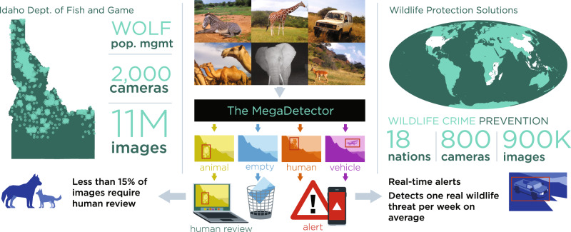
- Operational examples show scale: MegaDetector was used by Wildlife Protection Solutions across over 400 connected cameras in 18 countries, analyzing over 900K images in a year and detecting at least one real threat per week; Idaho Department of Fish and Game automated 9.5 million of 11 million camera trap images, halved labeling costs, and reduced a ~5-year labeling lag.
Methods
- Perspective/narrative review, not a primary empirical study; it synthesizes literature and case studies at the interface of machine learning, animal ecology, and wildlife conservation.
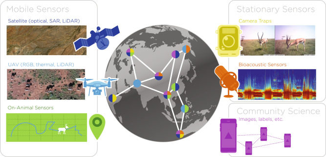
- Covers sensor types including camera traps, bioacoustic sensors, on-animal bio-loggers, UAVs, satellites, and community science, and ML tasks including detection/classification, individual re-identification, pose/3D reconstruction, environmental reconstruction, and species richness/interaction modeling.
- Main analysis is qualitative synthesis with cited performance examples; no systematic search strategy, meta-analysis, or new dataset is described.
Limitations
- Stated by the paper: geographic, sensor, and species biases can limit model generalization; quality control and uncertainty estimation are urgently needed; open data sharing carries ethical/privacy risks such as poacher access; and ML has environmental and financial costs.
- Stated by the paper: community science labels can be noisy or erroneous; drone flights below 150 m can significantly affect mammal behavior; passive acoustic monitoring and camera traps face data-scale, domain-shift, and labeled-data scarcity challenges.
- Evident from the text: as a Perspective, it is not a systematic review and reports selected examples rather than exhaustive evidence; it presents no primary data collection or formal quantitative synthesis.
Model-written summary. Check it against the paper before relying on it.
Integrity signals
Registry
Cites
Statistics
Figures

Verification
Claims the paper makes
67 Not checked yet · 62 No basis given · 23 Own interpretation · 2 Supported · 1 Partly supported · accuracy not yet measured
Every source the paper cites for this claim was checked and supports it.
In the paper
“Animal diversity is declining at an unprecedented rate1.”
§ Perspectives in machine learning for wildlife conservation > Technology to accelerate ecology and conservation research
What the sources say
- Supportedcites [1] Ceballos, G., Ehrlich, P. R. & Raven, P. H. Vertebrates on the brink as indicators of biological annihilation and the sixth mass extinction. Proc. Natl Acad. Sci. USA 117, 13596–13602 (2020). source
The paper’s Abstract states that current species extinction rates are hundreds or thousands of times faster than background rates. It also describes severe recent losses among vertebrates and invertebrates, supporting the broad paraphrase about rapidly declining animal diversity. (LLM, conf=0.92)
plain- Asserted: passes — The authors put it forward as true.
- Checkable: passes — It can be checked against evidence.
- Load-bearing: passes — The paper’s conclusions depend on it.
- Based: passes — The paper gives a reason why it holds.
- Supported
The cited sources support only part of this claim — read each source’s verdict below.
In the paper
“For these reasons, detecting and classifying animal species with DL for the purpose of population estimates is becoming increasingly popular for images52,53, acoustic spectrograms95, and videos96.”
§ Perspectives in machine learning for wildlife conservation > Machine learning to scale-up and automate animal ecology and conservation research > Wildlife detection and species-level classification
What the sources say
- Supportedcites [52] Beery, S., Wu, G., Rathod, V., Votel, R. & Huang, J. Context R-CNN: long term temporal context for per-camera object detection. in 2020 IEEE Conference on Computer Vision and Pattern Recognition (CVPR), 13075–13085 (2020). source
The citation is attached to the images portion of the sentence, not to acoustic spectrograms or videos. In the “Camera traps and other visual monitoring systems” passage (page not provided), the paper says image classification and object detection are increasingly explored to classify and count animal species in camera-trap data. (LLM, conf=0.92)
- Supportedcites [53] Norouzzadeh, M. S. et al. Automatically identifying, counting, and describing wild animals in camera-trap images with deep learning. Proc. Natl Acad. Sci. USA 115, E5716–E5725 (2018). source
For this source, the citation is attached to the image-based part of the sentence, not to acoustic spectrograms or videos. The Abstract describes deep-learning identification and counting of animals in camera-trap images as relevant to population estimation, and Related Work describes several recent deep-learning studies of camera-trap images. Page numbers are not supplied in our copy. (LLM, conf=0.91)
- Partly supportedcites [95] Mac Aodha, O. et al. Bat detective–deep learning tools for bat acoustic signal detection. PLoS Computat. Biol. 14, e1005995 (2018). sourceExperimental — accuracy not yet measured
The Methods (Acoustic detection pipeline) describe a deep-learning model that detects bat calls in spectrograms, and the Discussion links those detections to bat-population monitoring. The Discussion says adapting the detector for species classification is a future possibility; this study does not itself classify species or produce population estimates. (LLM, conf=0.86)
plain- Asserted: passes — The authors put it forward as true.
- Checkable: passes — It can be checked against evidence.
- Load-bearing: unclear — It is unclear whether the paper’s conclusions depend on it.
- Based: passes — The paper gives a reason why it holds.
- Supported
The paper states this without a source or data behind it here, so there is nothing to check it against. The quote shows it is in the paper.
In the paper
“We observe that skillful applications of state-of-the-art ML concepts for animal ecology now exist, thanks to corporate (e.g., Wildlife Insights) and research (AIDE, MegaDetector, DeepLabCut) efforts, but that there is still much room (and need) for genuinely new concepts pushed by interdisciplinary research, in particular towards hybrid models and new habitat distribution models at scale.”
§ Perspectives in machine learning for wildlife conservation > Conclusions
plaindirect- Asserted: passes — The authors put it forward as true.
- Checkable: passes — It can be checked against evidence.
- Load-bearing: passes — The paper’s conclusions depend on it.
- Based: passes — The paper gives a reason why it holds.
In the paper
“ML has emerged as a promising means of connecting the dots between big data and actionable ecological insights29”
§ Perspectives in machine learning for wildlife conservation > Technology to accelerate ecology and conservation research
What the sources say
- Not checked yetcites [29] Christin, S., Hervet, É. & Lecomte, N. Applications for deep learning in ecology. Methods Ecol. Evolution 10, 1632–1644 (2019). source
plaincorrelational- Asserted: passes — The authors put it forward as true.
- Checkable: passes — It can be checked against evidence.
- Load-bearing: passes — The paper’s conclusions depend on it.
- Based: passes — The paper gives a reason why it holds.
None of the sources cited for this claim have been checked yet.
In the paper
“There is a mismatch between the ever-growing volume of raw measures (videos, images, audio recordings) acquired for ecological studies and our ability to process and analyze this multi-source data to derive conclusive ecological insights rapidly and at scale.”
§ Perspectives in machine learning for wildlife conservation > Technology to accelerate ecology and conservation research
plaincorrelational- Asserted: passes — The authors put it forward as true.
- Checkable: passes — It can be checked against evidence.
- Load-bearing: passes — The paper’s conclusions depend on it.
- Based: passes — The paper gives a reason why it holds.
In the paper
“use of ML also massively reduces analysis costs, with reduction factors estimated between 2 and 1042.”
§ Perspectives in machine learning for wildlife conservation > Technology to accelerate ecology and conservation research
What the sources say
- Not checked yetcites [42] Eikelboom, J. A. J. et al. Improving the precision and accuracy of animal population estimates with aerial image object detection. Methods Ecol. Evolution 10, 1875–1887 (2019). source
hedgeddirect- Asserted: passes — The authors put it forward as true.
- Checkable: passes — It can be checked against evidence.
- Load-bearing: unclear — It is unclear whether the paper’s conclusions depend on it.
- Based: passes — The paper gives a reason why it holds.
None of the sources cited for this claim have been checked yet.
In the paper
“large mammal detection in the Kuzikus reserve in 2014 was improved significantly by improving the detection methodologies, from a recall rate of 20%35 to 80%37 (for a common 75% precision rate).”
§ Perspectives in machine learning for wildlife conservation > Technology to accelerate ecology and conservation research
What the sources say
- Not checked yetcites [35] Rey, N., Volpi, M., Joost, S. & Tuia, D. Detecting animals in African savanna with UAVs and the crowds. Remote Sens. Environ. 200, 341–351 (2017). source
- Not checked yetcites [37] Kellenberger, B., Marcos, D. & Tuia, D. When a few clicks make all the difference: improving weakly-supervised wildlife detection in UAV images. in Proceedings of the IEEE/CVF Conference on Computer Vision and Pattern Recognition Workshops (2019). source
plaindirectSingle case- Asserted: passes — The authors put it forward as true.
- Checkable: passes — It can be checked against evidence.
- Load-bearing: unclear — It is unclear whether the paper’s conclusions depend on it.
- Based: passes — The paper gives a reason why it holds.
None of the sources cited for this claim have been checked yet.
In the paper
“Significant error reduction of ML and DL with respect to traditional generalized regression models has been reported routinely for species richness and diversity estimation33,34.”
§ Perspectives in machine learning for wildlife conservation > Technology to accelerate ecology and conservation research
What the sources say
- Not checked yetcites [33] Pichler, M., Boreux, V., Klein, A.-M., Schleuning, M. & Hartig, F. Machine learning algorithms to infer trait-matching and predict species interactions in ecological networks. Methods Ecol. Evolution 11, 281–293 (2020). source
- Not checked yetcites [34] Knudby, A., LeDrew, E. & Brenning, A. Predictive mapping of reef fish species richness, diversity and biomass in Zanzibar using IKONOS imagery and machine-learning techniques. Remote Sens. Environ. 114, 1230–1241 (2010). source
boosteddirect- Asserted: passes — The authors put it forward as true.
- Checkable: passes — It can be checked against evidence.
- Load-bearing: unclear — It is unclear whether the paper’s conclusions depend on it.
- Based: passes — The paper gives a reason why it holds.
In the paper
“many animals are highly habitual and territorial, leading to very strong correlations between data taken days or even weeks apart from a single sensor52.”
§ Perspectives in machine learning for wildlife conservation > New sensors expand available data types for animal ecology > Stationary sensors
What the sources say
- Not checked yetcites [52] Beery, S., Wu, G., Rathod, V., Votel, R. & Huang, J. Context R-CNN: long term temporal context for per-camera object detection. in 2020 IEEE Conference on Computer Vision and Pattern Recognition (CVPR), 13075–13085 (2020). source
boosteddirect- Asserted: passes — The authors put it forward as true.
- Checkable: passes — It can be checked against evidence.
- Load-bearing: unclear — It is unclear whether the paper’s conclusions depend on it.
- Based: passes — The paper gives a reason why it holds.
In the paper
“problems related to lack of generality across geographies, day/night acquisition, or sensors are still major obstacles to production-ready accurate systems55.”
§ Perspectives in machine learning for wildlife conservation > New sensors expand available data types for animal ecology > Stationary sensors
What the sources say
- Not checked yetcites [55] Beery, S., Van Horn, G. & Perona, P. Recognition in terra incognita. in 2018 European Conference on Computer Vision (ECCV), 456–473 (2018). source
plaindirect- Asserted: passes — The authors put it forward as true.
- Checkable: passes — It can be checked against evidence.
- Load-bearing: passes — The paper’s conclusions depend on it.
- Based: passes — The paper gives a reason why it holds.
- It may state two separate claims as one. 60
- Probably not a substantial claim. 74
Every source the paper cites for this claim was checked and supports it.
In the paper
“Similarly ref. 139, incorporate knowledge about the distribution of species as well as photographer biases into a DL model for species classification in images and report accuracy improvements of up to 12% in iNaturalist over a baseline without such priors.”
§ Perspectives in machine learning for wildlife conservation > Attention points and opportunities > What’s new: vast scientific opportunities lie ahead
What the sources say
- Supportedcites [139] Mac Aodha, O., Cole, E. & Perona, P. Presence-only geographical priors for fine-grained image classification. in Proceedings of the IEEE/CVF International Conference on Computer Vision, 9596–9606 (2019). source
Split into 2 atoms — 2 confirmed, 0 partially supported, 0 disputed, 0 misattributed, 0 unverifiable. Expand the claim to see per-atom verdicts.
plaindirect- Asserted: passes — The authors put it forward as true.
- Checkable: passes — It can be checked against evidence.
- Load-bearing: unclear — It is unclear whether the paper’s conclusions depend on it.
- Based: passes — The paper gives a reason why it holds.
It may state two separate claims as one.
- Supported
The paper states this without a source or data behind it here, so there is nothing to check it against. The quote shows it is in the paper.
In the paper
“However, an interdisciplinary community of computer scientists and ecologists is emerging, which we hope will tackle this technological and societal challenge together.”
§ Perspectives in machine learning for wildlife conservation > Conclusions
plain- Asserted: passes — The authors put it forward as true.
- Checkable: fails — It may be too vague to check against evidence.
- Load-bearing: passes — The paper’s conclusions depend on it.
- Based: fails — The paper may give no reason why it holds.
Probably not a substantial claim. It may be too vague to check against evidence. The paper may give no reason why it holds.
In the paper
“Central challenges to efficient data analysis are the sheer volume of data generated by modern collection methods and the heterogeneous nature of many ecological datasets, which preclude the use of simple automated analysis techniques26.”
§ Perspectives in machine learning for wildlife conservation > Technology to accelerate ecology and conservation research
What the sources say
- Not checked yetcites [26] Farley, S. S., Dawson, A., Goring, S. J. & Williams, J. W. Situating ecology as a big-data science: current advances, challenges, and solutions. BioScience 68, 563–576 (2018). source
plaindirect- Asserted: passes — The authors put it forward as true.
- Checkable: passes — It can be checked against evidence.
- Load-bearing: passes — The paper’s conclusions depend on it.
- Based: passes — The paper gives a reason why it holds.
It may state two separate claims as one.
The paper states this without a source or data behind it here, so there is nothing to check it against. The quote shows it is in the paper.
In the paper
“but are limited by current processing approaches which inefficiently distill data into relevant information”
§ Perspectives in machine learning for wildlife conservation > Abstract
plaindirect- Asserted: passes — The authors put it forward as true.
- Checkable: fails — It may be too vague to check against evidence.
- Load-bearing: passes — The paper’s conclusions depend on it.
- Based: fails — The paper may give no reason why it holds.
Probably not a substantial claim. It may be too vague to check against evidence. The paper may give no reason why it holds.
The paper states this without a source or data behind it here, so there is nothing to check it against. The quote shows it is in the paper.
In the paper
“Inexpensive and accessible sensors are accelerating data acquisition in animal ecology.”
§ Perspectives in machine learning for wildlife conservation > Abstract
plaindirect- Asserted: passes — The authors put it forward as true.
- Checkable: passes — It can be checked against evidence.
- Load-bearing: passes — The paper’s conclusions depend on it.
- Based: fails — The paper may give no reason why it holds.
Probably not a substantial claim. The paper may give no reason why it holds.
In the paper
“a family of highly versatile ML models based on artificial neural networks that have shown superior performance across the majority of ML use cases”
§ Perspectives in machine learning for wildlife conservation > Technology to accelerate ecology and conservation research
What the sources say
- Not checked yetcites [32] LeCun, Y., Bengio, Y. & Hinton, G. Deep learning. Nature 521, 436–444 (2015). source
boostedcorrelational- Asserted: passes — The authors put it forward as true.
- Checkable: passes — It can be checked against evidence.
- Load-bearing: fails — The paper’s conclusions may not depend on it.
- Based: passes — The paper gives a reason why it holds.
Probably not a substantial claim. The paper’s conclusions may not depend on it.
None of the sources cited for this claim have been checked yet.
In the paper
“such hybrid models tend to be less data-intensive, avoid incoherent predictions, and are generally more interpretable than purely data-driven models.”
§ Perspectives in machine learning for wildlife conservation > Technology to accelerate ecology and conservation research
What the sources say
- Not checked yetcites [48] Reichstein, M. et al. Deep learning and process understanding for data-driven Earth system science. Nature 566, 195–204 (2019). source
- Not checked yetcites [49] Camps-Valls, G., Tuia, D., Zhu, X. X. & Reichstein, M. Deep Learning for the Earth Sciences: A Comprehensive Approach to Remote Sensing, Climate Science and Geosciences (Wiley & Sons, 2021). source
- Not checked yetcites [50] Karpatne, A. et al. Theory-guided data science: A new paradigm for scientific discovery from data. IEEE Trans. Knowl. Data Eng. 29, 2318–2331 (2017). source
plaindirect- Asserted: passes — The authors put it forward as true.
- Checkable: passes — It can be checked against evidence.
- Load-bearing: passes — The paper’s conclusions depend on it.
- Based: passes — The paper gives a reason why it holds.
It may state two separate claims as one.
In the paper
“Compared to camera traps, PAM is mostly unaffected by light and weather conditions (some factors like wind still play a role), senses the environment omnidirectionally, and tends to be cost-effective when data needs to be collected at large spatiotemporal scales with high resolution60.”
§ Perspectives in machine learning for wildlife conservation > New sensors expand available data types for animal ecology > Stationary sensors
What the sources say
- Not checked yetcites [60] Wood, C. M. et al. Detecting small changes in populations at landscape scales: a bioacoustic site-occupancy framework. Ecol. Indic. 98, 492–507 (2019). source
plain- Asserted: passes — The authors put it forward as true.
- Checkable: passes — It can be checked against evidence.
- Load-bearing: unclear — It is unclear whether the paper’s conclusions depend on it.
- Based: passes — The paper gives a reason why it holds.
It may state two separate claims as one.
The paper states this without a source or data behind it here, so there is nothing to check it against. The quote shows it is in the paper.
In the paper
“However, it is prudent to note that the viability of community science services may be limited depending on the task and that oftentimes substantial efforts are required to verify volunteer-annotated data.”
§ Perspectives in machine learning for wildlife conservation > New sensors expand available data types for animal ecology > Community science for crowd-sourcing data
hedgedconditional- Asserted: passes — The authors put it forward as true.
- Checkable: passes — It can be checked against evidence.
- Load-bearing: fails — The paper’s conclusions may not depend on it.
- Based: passes — The paper gives a reason why it holds.
Probably not a substantial claim. The paper’s conclusions may not depend on it. It may state two separate claims as one.
None of the sources cited for this claim have been checked yet.
In the paper
“Various supervised ML methods have shown their potential in automating behavior analysis from accelerometer data68,69, identifying behavioral state from trajectories70, and predicting animal movement71.”
§ Perspectives in machine learning for wildlife conservation > New sensors expand available data types for animal ecology > Remote sensing
What the sources say
- Not checked yetcites [68] Browning, E. et al. Predicting animal behaviour using deep learning: GPS data alone accurately predict diving in seabirds. Methods Ecol. Evolution 9, 681–692 (2018). source
- Not checked yetcites [69] Liu, Z. Y.-C. et al. Deep learning accurately predicts white shark locomotor activity from depth data. Anim. Biotelemetry 7, 1–13 (2019). source
- Not checked yetcites [70] Wang, G. Machine learning for inferring animal behavior from location and movement data. Ecol. Inform. 49, 69–76 (2019). source
plainconditional- Asserted: passes — The authors put it forward as true.
- Checkable: passes — It can be checked against evidence.
- Load-bearing: unclear — It is unclear whether the paper’s conclusions depend on it.
- Based: passes — The paper gives a reason why it holds.
It may state two separate claims as one.
In the paper
“While ML has been extensively applied to camera trap images, its application to long-term PAM datasets is still in its infancy and the first DL-based studies are only starting to appear”
§ Perspectives in machine learning for wildlife conservation > New sensors expand available data types for animal ecology > Stationary sensors
What the sources say
- Not checked yetcites [61] Kahl, S., Wood, C. M., Eibl, M. & Klinck, H. Birdnet: a deep learning solution for avian diversity monitoring. Ecol. Inform. 61, 101236 (2021). source
plain- Asserted: passes — The authors put it forward as true.
- Checkable: passes — It can be checked against evidence.
- Load-bearing: unclear — It is unclear whether the paper’s conclusions depend on it.
- Based: passes — The paper gives a reason why it holds.
It may state two separate claims as one.
None of the sources cited for this claim have been checked yet.
In the paper
“A recent study80 showed that flying at lower altitudes (e.g., lower than 150 m) can have a significant impact on group and individual behavior of mammals, although the severity of wildlife disturbance from drone deployments will depend heavily on the focal species, the equipment used, and characteristics of the drone flight (such as approach speed and altitude)81”
§ Perspectives in machine learning for wildlife conservation > New sensors expand available data types for animal ecology > Remote sensing
What the sources say
- Not checked yetcites [80] Schroeder, N. M., Panebianco, A., Gonzalez Musso, R. & Carmanchahi, P. An experimental approach to evaluate the potential of drones in terrestrial mammal research: a gregarious ungulate as a study model. R. Soc. open Sci. 7, 191482 (2020). source
- Not checked yetcites [81] Bennitt, E., Bartlam-Brooks, H. L. A., Hubel, T. Y. & Wilson, A. M. Terrestrial mammalian wildlife responses to Unmanned Aerial Systems approaches. Sci. Rep. 9, 1–10 (2019). source
plainconditional- Asserted: passes — The authors put it forward as true.
- Checkable: passes — It can be checked against evidence.
- Load-bearing: unclear — It is unclear whether the paper’s conclusions depend on it.
- Based: passes — The paper gives a reason why it holds.
It may state two separate claims as one.
In the paper
“On-animal sensors are the most common remote sensing devices deployed in animal ecology10.”
§ Perspectives in machine learning for wildlife conservation > New sensors expand available data types for animal ecology > Remote sensing
What the sources say
- Not checked yetcites [10] Kays, R., Crofoot, M. C., Jetz, W. & Wikelski, M. Terrestrial animal tracking as an eye on life and planet. Science 348, aaa2478 (2015). source
plain- Asserted: passes — The authors put it forward as true.
- Checkable: passes — It can be checked against evidence.
- Load-bearing: fails — The paper’s conclusions may not depend on it.
- Based: passes — The paper gives a reason why it holds.
Probably not a substantial claim. The paper’s conclusions may not depend on it.
In the paper
“Second, the inherent complexity of soundscapes requires noise-robust algorithms that generalize well and can separate and identify many animal sounds of interest from confounding natural and anthropogenic signals in a wide variety of acoustic environments62.”
§ Perspectives in machine learning for wildlife conservation > New sensors expand available data types for animal ecology > Stationary sensors
What the sources say
- Not checked yetcites [62] Stowell, D., Wood, M. D., Pamuła, H., Stylianou, Y. & Glotin, H. Automatic acoustic detection of birds through deep learning: the first bird audio detection challenge. Methods Ecol. Evolution 10, 368–380 (2019). source
plaindirect- Asserted: passes — The authors put it forward as true.
- Checkable: passes — It can be checked against evidence.
- Load-bearing: passes — The paper’s conclusions depend on it.
- Based: passes — The paper gives a reason why it holds.
It may state two separate claims as one.
A conclusion the paper draws from its own results — it cites no other source for it, so there is none to check. The quote shows it is in the paper.
In the paper
“integrating ecological domain knowledge into ML methods is essential to designing models that are accurate in the way they describe animal life.”
§ Perspectives in machine learning for wildlife conservation > Technology to accelerate ecology and conservation research
boosteddirect- Asserted: passes — The authors put it forward as true.
- Checkable: fails — It may be too vague to check against evidence.
- Load-bearing: passes — The paper’s conclusions depend on it.
- Based: passes — The paper gives a reason why it holds.
Probably not a substantial claim. It may be too vague to check against evidence.
A conclusion the paper draws from its own results — it cites no other source for it, so there is none to check. The quote shows it is in the paper.
In the paper
“We believe that the challenging nature of ecological data, compounded by the size of the datasets generated by novel sensors and the ever-increasing complexity of state-of-the-art ML methods, favor a collaborative approach that harnesses the expertise of both the ML and animal ecology communities, rather than an application of off-the-shelf ML methodologies to ecological challenges.”
§ Perspectives in machine learning for wildlife conservation > Technology to accelerate ecology and conservation research
plaindirect- Asserted: passes — The authors put it forward as true.
- Checkable: fails — It may be too vague to check against evidence.
- Load-bearing: passes — The paper’s conclusions depend on it.
- Based: passes — The paper gives a reason why it holds.
Probably not a substantial claim. It may be too vague to check against evidence.
A conclusion the paper draws from its own results — it cites no other source for it, so there is none to check. The quote shows it is in the paper.
In the paper
“The increased scale of available data due to de-siloing efforts from organizations like Wildlife Insights (www.wildlifeinsights.org) and LILA.science (www.lila.science) will help increase ML accuracy and robustness across regions and taxa.”
§ Perspectives in machine learning for wildlife conservation > New sensors expand available data types for animal ecology > Stationary sensors
plaindirect- Asserted: passes — The authors put it forward as true.
- Checkable: passes — It can be checked against evidence.
- Load-bearing: fails — The paper’s conclusions may not depend on it.
- Based: fails — The paper may give no reason why it holds.
Probably not a substantial claim. The paper’s conclusions may not depend on it. The paper may give no reason why it holds.
The paper states this without a source or data behind it here, so there is nothing to check it against. The quote shows it is in the paper.
In the paper
“Hosted for the first time in January 2016, it has become a regular event, held every other year.”
§ Perspectives in machine learning for wildlife conservation > New sensors expand available data types for animal ecology > Community science for crowd-sourcing data
plain- Asserted: passes — The authors put it forward as true.
- Checkable: passes — It can be checked against evidence.
- Load-bearing: fails — The paper’s conclusions may not depend on it.
- Based: passes — The paper gives a reason why it holds.
Probably not a substantial claim. The paper’s conclusions may not depend on it. It may state two separate claims as one.
A conclusion the paper draws from its own results — it cites no other source for it, so there is none to check. The quote shows it is in the paper.
In the paper
“The sensor data described in the previous section has the potential to unlock ecological understanding on a scale difficult to imagine in the recent past.”
§ Perspectives in machine learning for wildlife conservation > Machine learning to scale-up and automate animal ecology and conservation research
plainconditional- Asserted: passes — The authors put it forward as true.
- Checkable: fails — It may be too vague to check against evidence.
- Load-bearing: fails — The paper’s conclusions may not depend on it.
- Based: fails — The paper may give no reason why it holds.
Probably not a substantial claim. It may be too vague to check against evidence. The paper’s conclusions may not depend on it. The paper may give no reason why it holds.
The paper states this without a source or data behind it here, so there is nothing to check it against. The quote shows it is in the paper.
In the paper
“Hundreds of people, from school children and park rangers, to Nairobi families and international tourists, embark on a mission to photograph Grevy’s zebras across its range in Kenya, capturing ~50,000 images over the 2-day event.”
§ Perspectives in machine learning for wildlife conservation > New sensors expand available data types for animal ecology > Community science for crowd-sourcing data
plain- Asserted: passes — The authors put it forward as true.
- Checkable: passes — It can be checked against evidence.
- Load-bearing: fails — The paper’s conclusions may not depend on it.
- Based: passes — The paper gives a reason why it holds.
Probably not a substantial claim. The paper’s conclusions may not depend on it.
The paper states this without a source or data behind it here, so there is nothing to check it against. The quote shows it is in the paper.
In the paper
“Wildbook data has become the basis for the IUCN Red List global population numbers for several species”
§ Perspectives in machine learning for wildlife conservation > New sensors expand available data types for animal ecology > Community science for crowd-sourcing data
plaindirect- Asserted: passes — The authors put it forward as true.
- Checkable: passes — It can be checked against evidence.
- Load-bearing: fails — The paper’s conclusions may not depend on it.
- Based: passes — The paper gives a reason why it holds.
Probably not a substantial claim. The paper’s conclusions may not depend on it.
The paper states this without a source or data behind it here, so there is nothing to check it against. The quote shows it is in the paper.
In the paper
“it provides a substantial increase in the number of images and the chances of photographing species or single individuals in different regions, poses, and viewing angles.”
§ Perspectives in machine learning for wildlife conservation > New sensors expand available data types for animal ecology > Community science for crowd-sourcing data
plaindirect- Asserted: passes — The authors put it forward as true.
- Checkable: passes — It can be checked against evidence.
- Load-bearing: passes — The paper’s conclusions depend on it.
- Based: passes — The paper gives a reason why it holds.
It may state two separate claims as one.
In the paper
“The Great Grevy’s Rally, a community science-based wildlife census effort occurring every 2 years in Kenya92, is a successful demonstration of the power of community science-based wildlife monitoring.”
§ Perspectives in machine learning for wildlife conservation > New sensors expand available data types for animal ecology > Community science for crowd-sourcing data
What the sources say
- Not checked yetcites [92] Parham, J., Crall, J., Stewart, C., Berger-Wolf, T. & Rubenstein, D. I. Animal population censusing at scale with citizen science and photographic identification. in AAAI Spring Symposium-Technical Report (2017).
boosteddirectSingle case- Asserted: passes — The authors put it forward as true.
- Checkable: passes — It can be checked against evidence.
- Load-bearing: fails — The paper’s conclusions may not depend on it.
- Based: passes — The paper gives a reason why it holds.
Probably not a substantial claim. The paper’s conclusions may not depend on it.
The paper states this without a source or data behind it here, so there is nothing to check it against. The quote shows it is in the paper.
In the paper
“Wildbook supports collaborative mark-recapture, molecular ecology, and social ecology studies, especially where community science and artificial intelligence can help scale-up projects.”
§ Perspectives in machine learning for wildlife conservation > New sensors expand available data types for animal ecology > Community science for crowd-sourcing data
plaindirect- Asserted: passes — The authors put it forward as true.
- Checkable: passes — It can be checked against evidence.
- Load-bearing: unclear — It is unclear whether the paper’s conclusions depend on it.
- Based: passes — The paper gives a reason why it holds.
It may state two separate claims as one.
The paper states this without a source or data behind it here, so there is nothing to check it against. The quote shows it is in the paper.
In the paper
“The Great Grevy’s Rally has become the foundation of the Kenya Wildlife Service’s Grevy’s zebra endangered species management policy and generates the official IUCN Red List population numbers for the species.”
§ Perspectives in machine learning for wildlife conservation > New sensors expand available data types for animal ecology > Community science for crowd-sourcing data
plaindirect- Asserted: passes — The authors put it forward as true.
- Checkable: passes — It can be checked against evidence.
- Load-bearing: fails — The paper’s conclusions may not depend on it.
- Based: fails — The paper may give no reason why it holds.
Probably not a substantial claim. The paper’s conclusions may not depend on it. The paper may give no reason why it holds. It may state two separate claims as one.
The paper states this without a source or data behind it here, so there is nothing to check it against. The quote shows it is in the paper.
In the paper
“This is due to annotator errors, including misdetected or mislabeled animals due to annotator fatigue or insufficient knowledge about the annotation task, as well as systematic errors from adversarial annotators.”
§ Perspectives in machine learning for wildlife conservation > New sensors expand available data types for animal ecology > Community science for crowd-sourcing data
plaindirect- Asserted: passes — The authors put it forward as true.
- Checkable: passes — It can be checked against evidence.
- Load-bearing: fails — The paper’s conclusions may not depend on it.
- Based: passes — The paper gives a reason why it holds.
Probably not a substantial claim. The paper’s conclusions may not depend on it. It may state two separate claims as one.
The paper states this without a source or data behind it here, so there is nothing to check it against. The quote shows it is in the paper.
In the paper
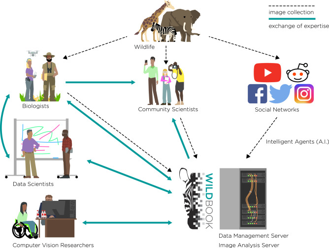
“Wildbook, a project of the non-profit Wild Me, is an open-source software platform that blends structured wildlife research with artificial intelligence, community science, and computer vision to speed population analysis and develop new insights to help conservation”
§ Perspectives in machine learning for wildlife conservation > New sensors expand available data types for animal ecology > Community science for crowd-sourcing data
plaindirect- Asserted: passes — The authors put it forward as true.
- Checkable: passes — It can be checked against evidence.
- Load-bearing: fails — The paper’s conclusions may not depend on it.
- Based: passes — The paper gives a reason why it holds.
Probably not a substantial claim. The paper’s conclusions may not depend on it.
The paper states this without a source or data behind it here, so there is nothing to check it against. The quote shows it is in the paper.
In the paper
“For simple tasks like animal detection, community science effort can be open to the public, while for more complex ones such as identifying bird species with subtle appearance differences (“fine-grained classification”, also see the glossary), communities of experts are needed to provide accurate labels.”
§ Perspectives in machine learning for wildlife conservation > New sensors expand available data types for animal ecology > Community science for crowd-sourcing data
plainconditional- Asserted: passes — The authors put it forward as true.
- Checkable: passes — It can be checked against evidence.
- Load-bearing: unclear — It is unclear whether the paper’s conclusions depend on it.
- Based: passes — The paper gives a reason why it holds.
It may state two separate claims as one.
In the paper
“out of more than 120,000 species monitored by the IUCN Red List of Threatened Species, up to 17,000 have a ‘Data deficient’ status2.”
§ Perspectives in machine learning for wildlife conservation > Technology to accelerate ecology and conservation research
What the sources say
- Not checked yetcites [2] Committee, T. I. R. L. The IUCN Red List of Threatened Species - Strategic Plan 2017-2020. Tech. Rep., IUCN (2017).
hedged- Asserted: passes — The authors put it forward as true.
- Checkable: passes — It can be checked against evidence.
- Load-bearing: fails — The paper’s conclusions may not depend on it.
- Based: passes — The paper gives a reason why it holds.
Probably not a substantial claim. The paper’s conclusions may not depend on it.
The paper states this without a source or data behind it here, so there is nothing to check it against. The quote shows it is in the paper.
In the paper
“services may be limited depending on the task and that oftentimes substantial efforts are required to verify volunteer-annotated data.”
§ Perspectives in machine learning for wildlife conservation > New sensors expand available data types for animal ecology > Community science for crowd-sourcing data
hedgedconditional- Asserted: passes — The authors put it forward as true.
- Checkable: passes — It can be checked against evidence.
- Load-bearing: unclear — It is unclear whether the paper’s conclusions depend on it.
- Based: passes — The paper gives a reason why it holds.
It may state two separate claims as one.
A conclusion the paper draws from its own results — it cites no other source for it, so there is none to check. The quote shows it is in the paper.
In the paper
“With the ability to identify individual animals in those images, Wildbook can enable an accurate population census and track population trends over time.”
§ Perspectives in machine learning for wildlife conservation > New sensors expand available data types for animal ecology > Community science for crowd-sourcing data
plaindirect- Asserted: passes — The authors put it forward as true.
- Checkable: passes — It can be checked against evidence.
- Load-bearing: passes — The paper’s conclusions depend on it.
- Based: passes — The paper gives a reason why it holds.
It may state two separate claims as one.
The paper states this without a source or data behind it here, so there is nothing to check it against. The quote shows it is in the paper.
In the paper
“Although this approach sacrifices control over image acquisitions and is likewise prone to inducing significant noise to datasets, for example through low-quality imagery”
§ Perspectives in machine learning for wildlife conservation > New sensors expand available data types for animal ecology > Community science for crowd-sourcing data
plaindirect- Asserted: passes — The authors put it forward as true.
- Checkable: passes — It can be checked against evidence.
- Load-bearing: unclear — It is unclear whether the paper’s conclusions depend on it.
- Based: passes — The paper gives a reason why it holds.
It may state two separate claims as one.
The paper states this without a source or data behind it here, so there is nothing to check it against. The quote shows it is in the paper.
In the paper
“There are currently Wildbooks for over 50 species, from sea dragons to zebras, spanning the entire planet.”
§ Perspectives in machine learning for wildlife conservation > New sensors expand available data types for animal ecology > Community science for crowd-sourcing data
plain- Asserted: passes — The authors put it forward as true.
- Checkable: passes — It can be checked against evidence.
- Load-bearing: fails — The paper’s conclusions may not depend on it.
- Based: passes — The paper gives a reason why it holds.
Probably not a substantial claim. The paper’s conclusions may not depend on it.
The paper states this without a source or data behind it here, so there is nothing to check it against. The quote shows it is in the paper.
In the paper
“More than 80 scientific publications have been enabled by Wildbook.”
§ Perspectives in machine learning for wildlife conservation > New sensors expand available data types for animal ecology > Community science for crowd-sourcing data
plaindirect- Asserted: passes — The authors put it forward as true.
- Checkable: passes — It can be checked against evidence.
- Load-bearing: fails — The paper’s conclusions may not depend on it.
- Based: fails — The paper may give no reason why it holds.
Probably not a substantial claim. The paper’s conclusions may not depend on it. The paper may give no reason why it holds.
The paper states this without a source or data behind it here, so there is nothing to check it against. The quote shows it is in the paper.
In the paper
“supported the change in conservation status for whale sharks from “vulnerable” to “endangered”.”
§ Perspectives in machine learning for wildlife conservation > New sensors expand available data types for animal ecology > Community science for crowd-sourcing data
plaindirect- Asserted: passes — The authors put it forward as true.
- Checkable: passes — It can be checked against evidence.
- Load-bearing: fails — The paper’s conclusions may not depend on it.
- Based: passes — The paper gives a reason why it holds.
Probably not a substantial claim. The paper’s conclusions may not depend on it.
None of the sources cited for this claim have been checked yet.
In the paper
“The image analysis of Wildbook can start with images from any source—scientists, camera traps, drones, community scientists, or social media—and use ML and computer vision to detect multiple animals in the images100 to not only classify their species, but identify individual animals applying a suite of different algorithms101,147.”
§ Perspectives in machine learning for wildlife conservation > New sensors expand available data types for animal ecology > Community science for crowd-sourcing data
What the sources say
- Not checked yetcites [100] Parham, J. et al. An animal detection pipeline for identification. in IEEE Winter Conference on Applications of Computer Vision (WACV), 1075–1083 (IEEE, 2018). source
- Not checked yetcites [101] Weideman, H. et al. Extracting identifying contours for African elephants and humpback whales using a learned appearance model. in Proceedings of the IEEE/CVF Winter Conference on Applications of Computer Vision (WACV) (2020). source
- Not checked yetcites [147] Arzoumanian, Z., Holmberg, J. & Norman, B. An astronomical pattern-matching algorithm for computer-aided identification of whale sharks Rhincodon typus. J. Appl. Ecol. 42, 999–1011 (2005). source
plaindirect- Asserted: passes — The authors put it forward as true.
- Checkable: passes — It can be checked against evidence.
- Load-bearing: unclear — It is unclear whether the paper’s conclusions depend on it.
- Based: passes — The paper gives a reason why it holds.
It may state two separate claims as one.
A conclusion the paper draws from its own results — it cites no other source for it, so there is none to check. The quote shows it is in the paper.
In the paper
“But to do so, it must be interpreted and converted to usable information for ecological research.”
§ Perspectives in machine learning for wildlife conservation > Machine learning to scale-up and automate animal ecology and conservation research
plaindirect- Asserted: passes — The authors put it forward as true.
- Checkable: fails — It may be too vague to check against evidence.
- Load-bearing: passes — The paper’s conclusions depend on it.
- Based: passes — The paper gives a reason why it holds.
Probably not a substantial claim. It may be too vague to check against evidence.
In the paper
“The measures yielded by this conversion, reviewed in this section, are also sometimes referred to as animal biometrics93.”
§ Perspectives in machine learning for wildlife conservation > Machine learning to scale-up and automate animal ecology and conservation research
What the sources say
- Not checked yetcites [93] Kühl, H. S. & Burghardt, T. Animal biometrics: quantifying and detecting phenotypic appearance. Trends Ecol. Evolution 28, 432–441 (2013). source
hedged- Asserted: passes — The authors put it forward as true.
- Checkable: passes — It can be checked against evidence.
- Load-bearing: fails — The paper’s conclusions may not depend on it.
- Based: passes — The paper gives a reason why it holds.
Probably not a substantial claim. The paper’s conclusions may not depend on it.
The paper states this without a source or data behind it here, so there is nothing to check it against. The quote shows it is in the paper.
In the paper
“Second, computational restrictions in these models limit the number of training examples, which is likely to have detrimental effects on variations in data (temporal, seasonal, etc.), thus reducing the generalization capabilities to new sensor deployments or regions.”
§ Perspectives in machine learning for wildlife conservation > Machine learning to scale-up and automate animal ecology and conservation research > Wildlife detection and species-level classification
hedgedconditional- Asserted: passes — The authors put it forward as true.
- Checkable: passes — It can be checked against evidence.
- Load-bearing: passes — The paper’s conclusions depend on it.
- Based: passes — The paper gives a reason why it holds.
It may state two separate claims as one.
The paper states this without a source or data behind it here, so there is nothing to check it against. The quote shows it is in the paper.
In the paper
“WPS used the MegaDetector to analyze over 900K images last year alone, which comes out to 2.5K images per day.”
§ Perspectives in machine learning for wildlife conservation > Machine learning to scale-up and automate animal ecology and conservation research > Wildlife detection and species-level classification
plain- Asserted: passes — The authors put it forward as true.
- Checkable: passes — It can be checked against evidence.
- Load-bearing: fails — The paper’s conclusions may not depend on it.
- Based: passes — The paper gives a reason why it holds.
Probably not a substantial claim. The paper’s conclusions may not depend on it. It may state two separate claims as one.
The paper states this without a source or data behind it here, so there is nothing to check it against. The quote shows it is in the paper.
In the paper
“Conservation efforts of endangered species require knowledge on how many individuals of the species in question are present in a study area.”
§ Perspectives in machine learning for wildlife conservation > Machine learning to scale-up and automate animal ecology and conservation research > Wildlife detection and species-level classification
plaindirect- Asserted: passes — The authors put it forward as true.
- Checkable: passes — It can be checked against evidence.
- Load-bearing: passes — The paper’s conclusions depend on it.
- Based: fails — The paper may give no reason why it holds.
Probably not a substantial claim. The paper may give no reason why it holds.
The paper states this without a source or data behind it here, so there is nothing to check it against. The quote shows it is in the paper.
In the paper
“They have over 400 connected cameras deployed in 18 different countries, and that number is growing rapidly.”
§ Perspectives in machine learning for wildlife conservation > Machine learning to scale-up and automate animal ecology and conservation research > Wildlife detection and species-level classification
plain- Asserted: passes — The authors put it forward as true.
- Checkable: passes — It can be checked against evidence.
- Load-bearing: fails — The paper’s conclusions may not depend on it.
- Based: passes — The paper gives a reason why it holds.
Probably not a substantial claim. The paper’s conclusions may not depend on it. It may state two separate claims as one.
A conclusion the paper draws from its own results — it cites no other source for it, so there is none to check. The quote shows it is in the paper.
In the paper
“It is these observations where imaging sensors (camera traps, UAVs, etc.), paired with ML models that detect and count individuals in the imagery, can provide the most significant input.”
§ Perspectives in machine learning for wildlife conservation > Machine learning to scale-up and automate animal ecology and conservation research > Wildlife detection and species-level classification
plaindirect- Asserted: passes — The authors put it forward as true.
- Checkable: passes — It can be checked against evidence.
- Load-bearing: passes — The paper’s conclusions depend on it.
- Based: fails — The paper may give no reason why it holds.
Probably not a substantial claim. The paper may give no reason why it holds.
In the paper
“This generic, global-scale human, animal, and vehicle detection model works off-the-shelf for most camera trap data”
§ Perspectives in machine learning for wildlife conservation > Machine learning to scale-up and automate animal ecology and conservation research > Wildlife detection and species-level classification
What the sources say
- Not checked yetcites [36] Beery, S., Morris, D. & Yang, S. Efficient pipeline for camera trap image review. in Proceedings of the Workshop Data Mining and AI for Conservation, Conference for Knowledge Discovery and Data Mining (2019).
plainn = 2- Asserted: passes — The authors put it forward as true.
- Checkable: passes — It can be checked against evidence.
- Load-bearing: unclear — It is unclear whether the paper’s conclusions depend on it.
- Based: passes — The paper gives a reason why it holds.
It may state two separate claims as one.
The paper states this without a source or data behind it here, so there is nothing to check it against. The quote shows it is in the paper.
In the paper
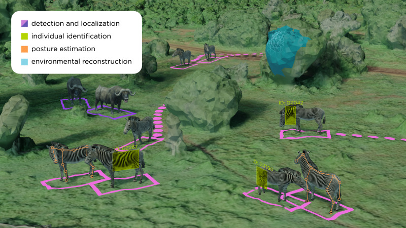
“Interestingly, the tasks involved in the different approaches show similarities with traditional tasks in ML and computer vision (e.g., detection, localization, identification, pose estimation), for which we provide a matching example in animal ecology in Fig. 5.”
§ Perspectives in machine learning for wildlife conservation > Machine learning to scale-up and automate animal ecology and conservation research
plaincorrelational- Asserted: passes — The authors put it forward as true.
- Checkable: passes — It can be checked against evidence.
- Load-bearing: fails — The paper’s conclusions may not depend on it.
- Based: passes — The paper gives a reason why it holds.
Probably not a substantial claim. The paper’s conclusions may not depend on it.
The paper states this without a source or data behind it here, so there is nothing to check it against. The quote shows it is in the paper.
In the paper
“Such estimations are conventionally realized with statistical occurrence models that are informed by sample-based species observations.”
§ Perspectives in machine learning for wildlife conservation > Machine learning to scale-up and automate animal ecology and conservation research > Wildlife detection and species-level classification
plain- Asserted: passes — The authors put it forward as true.
- Checkable: passes — It can be checked against evidence.
- Load-bearing: fails — The paper’s conclusions may not depend on it.
- Based: fails — The paper may give no reason why it holds.
Probably not a substantial claim. The paper’s conclusions may not depend on it. The paper may give no reason why it holds.
The paper states this without a source or data behind it here, so there is nothing to check it against. The quote shows it is in the paper.
In the paper
“allowed IDFG to label all data before the start of the next monitoring season, whereas manual labeling previously resulted in a lag of ~5 years from image collection to completion of labeling.”
§ Perspectives in machine learning for wildlife conservation > Machine learning to scale-up and automate animal ecology and conservation research > Wildlife detection and species-level classification
plaindirectSingle case- Asserted: passes — The authors put it forward as true.
- Checkable: passes — It can be checked against evidence.
- Load-bearing: passes — The paper’s conclusions depend on it.
- Based: passes — The paper gives a reason why it holds.
It may state two separate claims as one.
The paper states this without a source or data behind it here, so there is nothing to check it against. The quote shows it is in the paper.
In the paper
“IDFG relies heavily on camera traps to estimate and monitor this wolf population, and needs to process the data collected each year before the start of the next season in order to make informed policy changes or conservation interventions.”
§ Perspectives in machine learning for wildlife conservation > Machine learning to scale-up and automate animal ecology and conservation research > Wildlife detection and species-level classification
plain- Asserted: passes — The authors put it forward as true.
- Checkable: passes — It can be checked against evidence.
- Load-bearing: passes — The paper’s conclusions depend on it.
- Based: passes — The paper gives a reason why it holds.
It may state two separate claims as one.
None of the sources cited for this claim have been checked yet.
In the paper
“The standard for identification of animal species and identity is DNA profiling97, which can be difficult to scale to large, distributed populations54,93.”
§ Perspectives in machine learning for wildlife conservation > Machine learning to scale-up and automate animal ecology and conservation research > Individual re-identification
What the sources say
- Not checked yetcites [97] Avise, J. C. Molecular Markers, Natural History and Evolution (Springer Science & Business Media, 2012).
- Not checked yetcites [54] Schneider, S., Taylor, G. W., Linquist, S. & Kremer, S. C. Past, present and future approaches using computer vision for animal re-identification from camera trap data. Methods Ecol. Evolution 10, 461–470 (2019). source
- Not checked yetcites [93] Kühl, H. S. & Burghardt, T. Animal biometrics: quantifying and detecting phenotypic appearance. Trends Ecol. Evolution 28, 432–441 (2013). source
plain- Asserted: passes — The authors put it forward as true.
- Checkable: passes — It can be checked against evidence.
- Load-bearing: passes — The paper’s conclusions depend on it.
- Based: passes — The paper gives a reason why it holds.
It may state two separate claims as one.
The paper states this without a source or data behind it here, so there is nothing to check it against. The quote shows it is in the paper.
In the paper
“For example, such conversion can take the form of abundance mapping, individual animal re-identification, herd tracking, or digital reconstruction (three-dimensional, phenotypical) of the environment the animals live in.”
§ Perspectives in machine learning for wildlife conservation > Machine learning to scale-up and automate animal ecology and conservation research
plain- Asserted: passes — The authors put it forward as true.
- Checkable: passes — It can be checked against evidence.
- Load-bearing: fails — The paper’s conclusions may not depend on it.
- Based: passes — The paper gives a reason why it holds.
Probably not a substantial claim. The paper’s conclusions may not depend on it. It may state two separate claims as one.
The paper states this without a source or data behind it here, so there is nothing to check it against. The quote shows it is in the paper.
In the paper
“the publicly-hosted MegaDetector API has been integrated into the wildlife monitoring workflows of over 30 organizations worldwide, including the Wildlife Conservation Society, San Diego Zoo Global, and Island Conservation.”
§ Perspectives in machine learning for wildlife conservation > Machine learning to scale-up and automate animal ecology and conservation research > Wildlife detection and species-level classification
plain- Asserted: passes — The authors put it forward as true.
- Checkable: passes — It can be checked against evidence.
- Load-bearing: fails — The paper’s conclusions may not depend on it.
- Based: fails — The paper may give no reason why it holds.
Probably not a substantial claim. The paper’s conclusions may not depend on it. The paper may give no reason why it holds.
In the paper
“where humans achieved identification accuracy between 20% (novices) and 42% (experts) with an annotation time between 1 and 2 h, the DL model achieved an identification accuracy of 84% in a matter of seconds.”
§ Perspectives in machine learning for wildlife conservation > Machine learning to scale-up and automate animal ecology and conservation research > Individual re-identification
What the sources say
- Not checked yetcites [38] Schofield, D. et al. Chimpanzee face recognition from videos in the wild using deep learning. Sci. Adv. 5, eaaw0736 (2019). source
plain- Asserted: passes — The authors put it forward as true.
- Checkable: passes — It can be checked against evidence.
- Load-bearing: passes — The paper’s conclusions depend on it.
- Based: passes — The paper gives a reason why it holds.
It may state two separate claims as one.
In the paper
“a study of a small group of 23 chimpanzees in Guinea applied facial recognition techniques to a multi-year dataset comprising 1 million images and achieved >90% accuracy38.”
§ Perspectives in machine learning for wildlife conservation > Machine learning to scale-up and automate animal ecology and conservation research > Individual re-identification
What the sources say
- Not checked yetcites [38] Schofield, D. et al. Chimpanzee face recognition from videos in the wild using deep learning. Sci. Adv. 5, eaaw0736 (2019). source
plain- Asserted: passes — The authors put it forward as true.
- Checkable: passes — It can be checked against evidence.
- Load-bearing: unclear — It is unclear whether the paper’s conclusions depend on it.
- Based: passes — The paper gives a reason why it holds.
It may state two separate claims as one.
The paper states this without a source or data behind it here, so there is nothing to check it against. The quote shows it is in the paper.
In the paper
“The 3D shape of an individual can be related to its health, age, or reproductive status”
§ Perspectives in machine learning for wildlife conservation > Machine learning to scale-up and automate animal ecology and conservation research > Animal synthesis and reconstruction
plaincorrelational- Asserted: passes — The authors put it forward as true.
- Checkable: passes — It can be checked against evidence.
- Load-bearing: passes — The paper’s conclusions depend on it.
- Based: fails — The paper may give no reason why it holds.
Probably not a substantial claim. The paper may give no reason why it holds.
None of the sources cited for this claim have been checked yet.
In the paper
“As an alternative to gene-based identification, manual tagging can be used to keep track of individual animals10,93.”
§ Perspectives in machine learning for wildlife conservation > Machine learning to scale-up and automate animal ecology and conservation research > Individual re-identification
What the sources say
- Not checked yetcites [10] Kays, R., Crofoot, M. C., Jetz, W. & Wikelski, M. Terrestrial animal tracking as an eye on life and planet. Science 348, aaa2478 (2015). source
- Not checked yetcites [93] Kühl, H. S. & Burghardt, T. Animal biometrics: quantifying and detecting phenotypic appearance. Trends Ecol. Evolution 28, 432–441 (2013). source
plaindirect- Asserted: passes — The authors put it forward as true.
- Checkable: passes — It can be checked against evidence.
- Load-bearing: fails — The paper’s conclusions may not depend on it.
- Based: passes — The paper gives a reason why it holds.
Probably not a substantial claim. The paper’s conclusions may not depend on it.
In the paper
“The particular challenges for animal (re-)identification in wild populations are related to the difficulty of manual curation, larger populations, changes in appearance (e.g., due to scars, growth), few sightings per individual, and the frequent addition of new individuals that may enter the system due to birth or immigration, therefore creating an “open-set” problem104 wherein the model must deal”
§ Perspectives in machine learning for wildlife conservation > Machine learning to scale-up and automate animal ecology and conservation research > Individual re-identification
What the sources say
- Not checked yetcites [104] Bendale, A. & Boult, T. E. Towards open set deep networks. in 2016 IEEE Conference on Computer Vision and Pattern Recognition (CVPR), 1563–1572 (2016). source
plaindirect- Asserted: passes — The authors put it forward as true.
- Checkable: passes — It can be checked against evidence.
- Load-bearing: passes — The paper’s conclusions depend on it.
- Based: passes — The paper gives a reason why it holds.
It may state two separate claims as one.
In the paper
“Recent work defines the SMAL (Skinned Multi-Animal Linear) model, a 3D articulated shape model for a set of quadruped families107.”
§ Perspectives in machine learning for wildlife conservation > Machine learning to scale-up and automate animal ecology and conservation research > Animal synthesis and reconstruction
What the sources say
- Not checked yetcites [107] Zuffi, S., Kanazawa, A., Jacobs, D. W. & Black, M. J. 3D menagerie: modeling the 3D shape and pose of animals. in 2017 IEEE Conference on Computer Vision and Pattern Recognition (CVPR), 6365–6373 (2017). source
plain- Asserted: passes — The authors put it forward as true.
- Checkable: passes — It can be checked against evidence.
- Load-bearing: fails — The paper’s conclusions may not depend on it.
- Based: passes — The paper gives a reason why it holds.
Probably not a substantial claim. The paper’s conclusions may not depend on it.
In the paper
“3D shape models have been recently defined also for birds111.”
§ Perspectives in machine learning for wildlife conservation > Machine learning to scale-up and automate animal ecology and conservation research > Animal synthesis and reconstruction
What the sources say
- Not checked yetcites [111] Wang, Y., Kolotouros, N., Daniilidis, K. & Badger, M. Birds of a feather: capturing avian shape models from images. in 2021 IEEE Conference on Computer Vision and Pattern Recognition (CVPR), 14739–14749 (2021). source
plain- Asserted: passes — The authors put it forward as true.
- Checkable: passes — It can be checked against evidence.
- Load-bearing: fails — The paper’s conclusions may not depend on it.
- Based: passes — The paper gives a reason why it holds.
Probably not a substantial claim. The paper’s conclusions may not depend on it.
In the paper
“3D reconstructions of kill sites for lions in South Africa revealed novel insights into the predator-prey relationships and their connection to ecosystem stability and functioning114”
§ Perspectives in machine learning for wildlife conservation > Machine learning to scale-up and automate animal ecology and conservation research > Reconstructing the environment
What the sources say
- Not checked yetcites [114] Davies, A. B., Tambling, C. J., Kerley, G. I. H. & Asner, G. P. Effects of vegetation structure on the location of lion kill sites in African thicket. PLoS ONE 11, e0149098 (2016). source
plaincorrelational- Asserted: passes — The authors put it forward as true.
- Checkable: passes — It can be checked against evidence.
- Load-bearing: fails — The paper’s conclusions may not depend on it.
- Based: passes — The paper gives a reason why it holds.
Probably not a substantial claim. The paper’s conclusions may not depend on it.
In the paper
“In ref. 110, the SMAL model has been used in a DL approach to predict 3D shape and pose of the Grevy’s zebra from images.”
§ Perspectives in machine learning for wildlife conservation > Machine learning to scale-up and automate animal ecology and conservation research > Animal synthesis and reconstruction
What the sources say
- Not checked yetcites [110] Zuffi, S., Kanazawa, A., Berger-Wolf, T. & Black, M. J. Three-D safari: learning to estimate zebra pose, shape, and texture from images" in the wild". in 2019 IEEE International Conference on Computer Vision (ICCV), 5359–5368 (2019). source
plain- Asserted: passes — The authors put it forward as true.
- Checkable: passes — It can be checked against evidence.
- Load-bearing: fails — The paper’s conclusions may not depend on it.
- Based: passes — The paper gives a reason why it holds.
Probably not a substantial claim. The paper’s conclusions may not depend on it.
None of the sources cited for this claim have been checked yet.
In the paper
“Such spatial reconstructions of the environment can either be extracted by using dedicated sensors such as LiDAR116 or can be reconstructed from multiple images, either by stitching the images into a unified two-dimensional panorama (e.g., mosaicking117) or by computing the three-dimensional environment from partially overlapping images (e.g., structure from motion118 or simultaneous localization”
§ Perspectives in machine learning for wildlife conservation > Machine learning to scale-up and automate animal ecology and conservation research > Reconstructing the environment
What the sources say
- Not checked yetcites [116] Risse, B., Mangan, M., Stürzl, W. & Webb, B. Software to convert terrestrial LiDAR scans of natural environments into photorealistic meshes. Environ. Model. Softw. 99, 88–100 (2018). source
- Not checked yetcites [117] Haalck, L. & Risse, B. Embedded dense camera trajectories in multi-video image mosaics by geodesic interpolation-based reintegration. in 2021 IEEE Winter Conference on Applications of Computer Vision (WACV), 1849–1858 (2021). source
- Not checked yetcites [118] Schonberger, J. L. & Frahm, J.-M. Structure-from-motion revisited. in 2016 IEEE Conference on Computer Vision and Pattern Recognition (CVPR), 4104–4113 (2016). source
plaindirect- Asserted: passes — The authors put it forward as true.
- Checkable: passes — It can be checked against evidence.
- Load-bearing: unclear — It is unclear whether the paper’s conclusions depend on it.
- Based: passes — The paper gives a reason why it holds.
It may state two separate claims as one.
The paper states this without a source or data behind it here, so there is nothing to check it against. The quote shows it is in the paper.
In the paper
“the 3D pose of the body can provide finer information with respect to posture attributes and allows, for instance, kinematic as well as behavioral analyses.”
§ Perspectives in machine learning for wildlife conservation > Machine learning to scale-up and automate animal ecology and conservation research > Animal synthesis and reconstruction
plaindirect- Asserted: passes — The authors put it forward as true.
- Checkable: passes — It can be checked against evidence.
- Load-bearing: unclear — It is unclear whether the paper’s conclusions depend on it.
- Based: passes — The paper gives a reason why it holds.
It may state two separate claims as one.
In the paper
“Satellite remote sensing has become an integral part to study animal habitats, biological diversity, and spatiotemporal changes of abiotic conditions113, since it allows to map quantities like land cover, soil moisture, or temperature at scale.”
§ Perspectives in machine learning for wildlife conservation > Machine learning to scale-up and automate animal ecology and conservation research > Reconstructing the environment
What the sources say
- Not checked yetcites [113] Pettorelli, N. et al. Satellite remote sensing for applied ecologists: opportunities and challenges. J. Appl. Ecol. 51, 839–848 (2014). source
plaindirect- Asserted: passes — The authors put it forward as true.
- Checkable: passes — It can be checked against evidence.
- Load-bearing: unclear — It is unclear whether the paper’s conclusions depend on it.
- Based: passes — The paper gives a reason why it holds.
It may state two separate claims as one.
The paper states this without a source or data behind it here, so there is nothing to check it against. The quote shows it is in the paper.
In the paper
“Image-based 3D pose and shape estimation methods provide rich information about individuals but require, in addition to accurate shape models, prior knowledge about the animal’s 3D motion.”
§ Perspectives in machine learning for wildlife conservation > Machine learning to scale-up and automate animal ecology and conservation research > Animal synthesis and reconstruction
plaindirect- Asserted: passes — The authors put it forward as true.
- Checkable: passes — It can be checked against evidence.
- Load-bearing: unclear — It is unclear whether the paper’s conclusions depend on it.
- Based: passes — The paper gives a reason why it holds.
It may state two separate claims as one.
None of the sources cited for this claim have been checked yet.
In the paper
“Biggs et al. built on this work for 3D shape and motion of dogs from video108 and for recovery of dog shape and pose across many different breeds109.”
§ Perspectives in machine learning for wildlife conservation > Machine learning to scale-up and automate animal ecology and conservation research > Animal synthesis and reconstruction
What the sources say
- Not checked yetcites [108] Biggs, B., Roddick, T., Fitzgibbon, A. & Cipolla, R. Creatures great and smal: recovering the shape and motion of animals from video. in 2018 Asian Conference on Computer Vision (ACCV), 3–19 (Springer, 2018). source
- Not checked yetcites [109] Biggs, B., Boyne, O., Charles, J., Fitzgibbon, A. & Cipolla, R. Who left the dogs out? 3D animal reconstruction with expectation maximization in the loop. in 2020 European Conference on Computer Vision (ECCV), 195–211 (Springer, 2020). source
plaindirect- Asserted: passes — The authors put it forward as true.
- Checkable: passes — It can be checked against evidence.
- Load-bearing: fails — The paper’s conclusions may not depend on it.
- Based: passes — The paper gives a reason why it holds.
Probably not a substantial claim. The paper’s conclusions may not depend on it. It may state two separate claims as one.
The paper states this without a source or data behind it here, so there is nothing to check it against. The quote shows it is in the paper.
In the paper
“Wildlife behavior and conservation cannot be dissociated from the environment animals evolve and live in.”
§ Perspectives in machine learning for wildlife conservation > Machine learning to scale-up and automate animal ecology and conservation research > Reconstructing the environment
plaincorrelational- Asserted: passes — The authors put it forward as true.
- Checkable: fails — It may be too vague to check against evidence.
- Load-bearing: passes — The paper’s conclusions depend on it.
- Based: fails — The paper may give no reason why it holds.
Probably not a substantial claim. It may be too vague to check against evidence. The paper may give no reason why it holds.
In the paper
“Various user-friendly toolboxes are available to extract the 2D posture of animals from videos (Fig. 1d, e), while the user can define which body parts should be estimated (reviewed in ref. 76).”
§ Perspectives in machine learning for wildlife conservation > Machine learning to scale-up and automate animal ecology and conservation research > Animal synthesis and reconstruction
What the sources say
- Not checked yetcites [76] Mathis, A., Schneider, S., Lauer, J. & Mathis, M. W. A primer on motion capture with deep learning: principles, pitfalls, and perspectives. Neuron 108, 44–65 (2020). source
plain- Asserted: passes — The authors put it forward as true.
- Checkable: passes — It can be checked against evidence.
- Load-bearing: fails — The paper’s conclusions may not depend on it.
- Based: passes — The paper gives a reason why it holds.
Probably not a substantial claim. The paper’s conclusions may not depend on it. It may state two separate claims as one.
In the paper
“For pose estimation, marker-less methods based on DL have tremendously improved over the last years and already impacted biology105.”
§ Perspectives in machine learning for wildlife conservation > Machine learning to scale-up and automate animal ecology and conservation research > Animal synthesis and reconstruction
What the sources say
- Not checked yetcites [105] Mathis, M. W. & Mathis, A. Deep learning tools for the measurement of animal behavior in neuroscience. Curr. Opin. Neurobiol. 60, 1–11 (2020). source
boosteddirect- Asserted: passes — The authors put it forward as true.
- Checkable: passes — It can be checked against evidence.
- Load-bearing: unclear — It is unclear whether the paper’s conclusions depend on it.
- Based: passes — The paper gives a reason why it holds.
It may state two separate claims as one.
In the paper
“More recently, graph regression techniques were deployed to reconstruct species interaction networks in a community of European birds with promising results, including better causality estimates of the relations in the graph131.”
§ Perspectives in machine learning for wildlife conservation > Machine learning to scale-up and automate animal ecology and conservation research > Modeling species diversity, richness, and interactions
What the sources say
- Not checked yetcites [131] Faisal, A., Dondelinger, F., Husmeier, D. & Beale, C. M. Inferring species interaction networks from species abundance data: a comparative evaluation of various statistical and machine learning methods. Ecol. Inform. 5, 451–464 (2010). source
plaindirect- Asserted: passes — The authors put it forward as true.
- Checkable: passes — It can be checked against evidence.
- Load-bearing: unclear — It is unclear whether the paper’s conclusions depend on it.
- Based: passes — The paper gives a reason why it holds.
It may state two separate claims as one.
None of the sources cited for this claim have been checked yet.
In the paper
“Non-parametric ML techniques like Random Forest126 have been successfully used to predict species richness and have shown significant error reduction with respect to the traditional counterparts used in ecology, for example in the estimation of richness distributions of fishes127,128, spiders 129, and small mammals130.”
§ Perspectives in machine learning for wildlife conservation > Machine learning to scale-up and automate animal ecology and conservation research > Modeling species diversity, richness, and interactions
What the sources say
- Not checked yetcites [126] Breiman, L. Random forests. Mach. Learn. 45, 5–32 (2001). source
- Not checked yetcites [127] Parravicini, V. et al. Global patterns and predictors of tropical reef fish species richness. Ecography 36, 1254–1262 (2013). source
- Not checked yetcites [128] Smoliński, S. & Radtke, K. Spatial prediction of demersal fish diversity in the baltic sea: comparison of machine learning and regression-based techniques. ICES J. Mar. Sci. 74, 102–111 (2017). source
boosteddirect- Asserted: passes — The authors put it forward as true.
- Checkable: passes — It can be checked against evidence.
- Load-bearing: unclear — It is unclear whether the paper’s conclusions depend on it.
- Based: passes — The paper gives a reason why it holds.
It may state two separate claims as one.
None of the sources cited for this claim have been checked yet.
In the paper
“Spatially explicit linear regression models have been conventionally used to predict species and community distribution based on explanatory variables such as climate and topography124,125.”
§ Perspectives in machine learning for wildlife conservation > Machine learning to scale-up and automate animal ecology and conservation research > Modeling species diversity, richness, and interactions
What the sources say
- Not checked yetcites [124] Guisan, A. & Zimmermann, N. E. Predictive habitat distribution models in ecology. Ecol. Model. 135, 147–186 (2000). source
- Not checked yetcites [125] Lehmann, A., Overton, J. M. & Austin, M. P. Regression models for spatial prediction: their role for biodiversity and conservation. Biodivers. Conserv. 11, 2085–2092 (2002). source
plaincorrelational- Asserted: passes — The authors put it forward as true.
- Checkable: passes — It can be checked against evidence.
- Load-bearing: fails — The paper’s conclusions may not depend on it.
- Based: passes — The paper gives a reason why it holds.
Probably not a substantial claim. The paper’s conclusions may not depend on it.
The paper states this without a source or data behind it here, so there is nothing to check it against. The quote shows it is in the paper.
In the paper
“Analyses of biodiversity, represented by such measures as species abundance and richness, are foundational to much ecological research and many conservation initiatives.”
§ Perspectives in machine learning for wildlife conservation > Machine learning to scale-up and automate animal ecology and conservation research > Modeling species diversity, richness, and interactions
plain- Asserted: passes — The authors put it forward as true.
- Checkable: passes — It can be checked against evidence.
- Load-bearing: fails — The paper’s conclusions may not depend on it.
- Based: fails — The paper may give no reason why it holds.
Probably not a substantial claim. The paper’s conclusions may not depend on it. The paper may give no reason why it holds.
The paper states this without a source or data behind it here, so there is nothing to check it against. The quote shows it is in the paper.
In the paper
“Tree-based methods are well-suited to these tasks because they perform explicit feature ranking (and thus feature selection) and are able to model nonlinear relationships between covariates and species distribution.”
§ Perspectives in machine learning for wildlife conservation > Machine learning to scale-up and automate animal ecology and conservation research > Modeling species diversity, richness, and interactions
boosteddirect- Asserted: passes — The authors put it forward as true.
- Checkable: passes — It can be checked against evidence.
- Load-bearing: unclear — It is unclear whether the paper’s conclusions depend on it.
- Based: passes — The paper gives a reason why it holds.
It may state two separate claims as one.
The paper states this without a source or data behind it here, so there is nothing to check it against. The quote shows it is in the paper.
In the paper
“Security of rangers themselves is also at stake; for example, the flight path of drones might be backtracked to reveal their location.”
§ Perspectives in machine learning for wildlife conservation > Attention points and opportunities > What can we focus on now?
hedgedconditional- Asserted: passes — The authors put it forward as true.
- Checkable: passes — It can be checked against evidence.
- Load-bearing: fails — The paper’s conclusions may not depend on it.
- Based: fails — The paper may give no reason why it holds.
Probably not a substantial claim. The paper’s conclusions may not depend on it. The paper may give no reason why it holds. It may state two separate claims as one.
A conclusion the paper draws from its own results — it cites no other source for it, so there is none to check. The quote shows it is in the paper.
In the paper
“population counts without uncertainty estimation can lead to erroneous and potentially devastating conclusions.”
§ Perspectives in machine learning for wildlife conservation > Attention points and opportunities > What can we focus on now?
plaindirect- Asserted: passes — The authors put it forward as true.
- Checkable: fails — It may be too vague to check against evidence.
- Load-bearing: passes — The paper’s conclusions depend on it.
- Based: fails — The paper may give no reason why it holds.
Probably not a substantial claim. It may be too vague to check against evidence. The paper may give no reason why it holds.
None of the sources cited for this claim have been checked yet.
In the paper
“Biases are not limited to the geographical provenance of images: the type of sensors used (RGB vs. infrared or thermal), the species they depict, and the imbalance in the number of individuals observed per species55,132 must also be considered when training or using models to avoid potentially catastrophic drop-offs in accuracy”
§ Perspectives in machine learning for wildlife conservation > Attention points and opportunities > What can we focus on now?
What the sources say
- Not checked yetcites [55] Beery, S., Van Horn, G. & Perona, P. Recognition in terra incognita. in 2018 European Conference on Computer Vision (ECCV), 456–473 (2018). source
- Not checked yetcites [132] Van Horn, G. et al. The inaturalist species classification and detection dataset. in 2018 IEEE Conference on Computer Vision and Pattern Recognition (CVPR), 8769–8778 (2018). source
plainconditional- Asserted: passes — The authors put it forward as true.
- Checkable: passes — It can be checked against evidence.
- Load-bearing: passes — The paper’s conclusions depend on it.
- Based: passes — The paper gives a reason why it holds.
It may state two separate claims as one.
The paper states this without a source or data behind it here, so there is nothing to check it against. The quote shows it is in the paper.
In the paper
“Such universality of ML is now strongly questioned and the inductive bias of traditional DL models is challenged by new approaches that bridge domain knowledge, fundamental laws, and data science.”
§ Perspectives in machine learning for wildlife conservation > Attention points and opportunities > What’s new: vast scientific opportunities lie ahead
boosteddirect- Asserted: passes — The authors put it forward as true.
- Checkable: fails — It may be too vague to check against evidence.
- Load-bearing: passes — The paper’s conclusions depend on it.
- Based: fails — The paper may give no reason why it holds.
Probably not a substantial claim. It may be too vague to check against evidence. The paper may give no reason why it holds. It may state two separate claims as one.
A conclusion the paper draws from its own results — it cites no other source for it, so there is none to check. The quote shows it is in the paper.
In the paper
“Machine and deep learning are becoming necessary accelerators for wildlife research and conservation actions in natural reserves.”
§ Perspectives in machine learning for wildlife conservation > Attention points and opportunities
plaindirect- Asserted: passes — The authors put it forward as true.
- Checkable: fails — It may be too vague to check against evidence.
- Load-bearing: passes — The paper’s conclusions depend on it.
- Based: fails — The paper may give no reason why it holds.
Probably not a substantial claim. It may be too vague to check against evidence. The paper may give no reason why it holds.
A conclusion the paper draws from its own results — it cites no other source for it, so there is none to check. The quote shows it is in the paper.
In the paper
“Without such quality control measures, relying on model-based results is risky and could have difficult-to-evaluate impacts on research in animal ecology, as incorrect results hidden in a suboptimally trained model will become more and more difficult to detect.”
§ Perspectives in machine learning for wildlife conservation > Attention points and opportunities > What can we focus on now?
hedgeddirect- Asserted: passes — The authors put it forward as true.
- Checkable: fails — It may be too vague to check against evidence.
- Load-bearing: passes — The paper’s conclusions depend on it.
- Based: passes — The paper gives a reason why it holds.
Probably not a substantial claim. It may be too vague to check against evidence.
A conclusion the paper draws from its own results — it cites no other source for it, so there is none to check. The quote shows it is in the paper.
In the paper
“Computer scientists must be aware that errors by their models can lead to erroneous decisions on site that can be catastrophic for the population they are trying to preserve or for the populations that live at the border of human/wildlife conflicts.”
§ Perspectives in machine learning for wildlife conservation > Attention points and opportunities > What can we focus on now?
plaindirect- Asserted: passes — The authors put it forward as true.
- Checkable: fails — It may be too vague to check against evidence.
- Load-bearing: passes — The paper’s conclusions depend on it.
- Based: fails — The paper may give no reason why it holds.
Probably not a substantial claim. It may be too vague to check against evidence. The paper may give no reason why it holds.
The paper states this without a source or data behind it here, so there is nothing to check it against. The quote shows it is in the paper.
In the paper
“Although cloud computing services exist that forgo the need of hardware management, they likewise pose per-resource costs that quickly scale to several thousands of dollars per month for a single virtual machine.”
§ Perspectives in machine learning for wildlife conservation > Attention points and opportunities > What can we focus on now?
plaindirect- Asserted: passes — The authors put it forward as true.
- Checkable: passes — It can be checked against evidence.
- Load-bearing: passes — The paper’s conclusions depend on it.
- Based: fails — The paper may give no reason why it holds.
Probably not a substantial claim. The paper may give no reason why it holds. It may state two separate claims as one.
The paper states this without a source or data behind it here, so there is nothing to check it against. The quote shows it is in the paper.
In the paper
“Even though the models currently used in animal ecology are far from such a carbon footprint”
§ Perspectives in machine learning for wildlife conservation > Attention points and opportunities > What can we focus on now?
plain- Asserted: passes — The authors put it forward as true.
- Checkable: passes — It can be checked against evidence.
- Load-bearing: fails — The paper’s conclusions may not depend on it.
- Based: fails — The paper may give no reason why it holds.
Probably not a substantial claim. The paper’s conclusions may not depend on it. The paper may give no reason why it holds.
In the paper
“recently, it has been estimated that large, state-of-the-art models for understanding natural language emit as much carbon as several cars in their entire lifetime135.”
§ Perspectives in machine learning for wildlife conservation > Attention points and opportunities > What can we focus on now?
What the sources say
- Not checked yetcites [135] Strubell, E., Ganesh, A. & McCallum, A. Energy and policy considerations for deep learning in NLP. in Proceedings of the 57th Annual Meeting of the Association for Computational Linguistics, 3645–3650 (2019). source
hedgeddirect- Asserted: passes — The authors put it forward as true.
- Checkable: passes — It can be checked against evidence.
- Load-bearing: fails — The paper’s conclusions may not depend on it.
- Based: passes — The paper gives a reason why it holds.
Probably not a substantial claim. The paper’s conclusions may not depend on it.
In the paper
“However, opening up existing datasets (and especially when using private-owned images acquired by non-professionals as in ref. 92) is both a necessary and difficult challenge for the near future.”
§ Perspectives in machine learning for wildlife conservation > Attention points and opportunities > What can we focus on now?
What the sources say
- Not checked yetcites [92] Parham, J., Crall, J., Stewart, C., Berger-Wolf, T. & Rubenstein, D. I. Animal population censusing at scale with citizen science and photographic identification. in AAAI Spring Symposium-Technical Report (2017).
plain- Asserted: passes — The authors put it forward as true.
- Checkable: fails — It may be too vague to check against evidence.
- Load-bearing: passes — The paper’s conclusions depend on it.
- Based: passes — The paper gives a reason why it holds.
Probably not a substantial claim. It may be too vague to check against evidence. It may state two separate claims as one.
In the paper
“In some cases, it is imperative that the privacy of the data be preserved, for instance to avoid giving poachers access to locations of animals in near-real-time134.”
§ Perspectives in machine learning for wildlife conservation > Attention points and opportunities > What can we focus on now?
What the sources say
- Not checked yetcites [134] Lennox, R. J. et al. A novel framework to protect animal data in a world of ecosurveillance. BioScience 70, 468–476 (2020). source
plaindirect- Asserted: passes — The authors put it forward as true.
- Checkable: fails — It may be too vague to check against evidence.
- Load-bearing: fails — The paper’s conclusions may not depend on it.
- Based: passes — The paper gives a reason why it holds.
Probably not a substantial claim. It may be too vague to check against evidence. The paper’s conclusions may not depend on it.
The paper states this without a source or data behind it here, so there is nothing to check it against. The quote shows it is in the paper.
In the paper
“Purchasing prices of such machines alone are often prohibitively high especially for budget-constrained conservation organizations; programming, running, and maintenance costs further add to the bill.”
§ Perspectives in machine learning for wildlife conservation > Attention points and opportunities > What can we focus on now?
plaindirect- Asserted: passes — The authors put it forward as true.
- Checkable: passes — It can be checked against evidence.
- Load-bearing: fails — The paper’s conclusions may not depend on it.
- Based: fails — The paper may give no reason why it holds.
Probably not a substantial claim. The paper’s conclusions may not depend on it. The paper may give no reason why it holds. It may state two separate claims as one.
A conclusion the paper draws from its own results — it cites no other source for it, so there is none to check. The quote shows it is in the paper.
In the paper
“Smaller models are not only less expensive to train and use, their lighter computational costs allow them to be run on smaller devices, opening opportunities for real-time ML “on the edge”—i.e., within the sensors themselves.”
§ Perspectives in machine learning for wildlife conservation > Attention points and opportunities > What can we focus on now?
plaindirect- Asserted: passes — The authors put it forward as true.
- Checkable: passes — It can be checked against evidence.
- Load-bearing: passes — The paper’s conclusions depend on it.
- Based: passes — The paper gives a reason why it holds.
Probably not a substantial claim. It may state two separate claims as one.
A conclusion the paper draws from its own results — it cites no other source for it, so there is none to check. The quote shows it is in the paper.
In the paper
“Fostering a culture of individual and cross-institutional data sharing in ecology will allow ML approaches to improve in robustness and accuracy.”
§ Perspectives in machine learning for wildlife conservation > Attention points and opportunities > What can we focus on now?
plaindirect- Asserted: passes — The authors put it forward as true.
- Checkable: fails — It may be too vague to check against evidence.
- Load-bearing: passes — The paper’s conclusions depend on it.
- Based: fails — The paper may give no reason why it holds.
Probably not a substantial claim. It may be too vague to check against evidence. The paper may give no reason why it holds.
The paper states this without a source or data behind it here, so there is nothing to check it against. The quote shows it is in the paper.
In the paper
“The estimations of models remain approximations and need to be treated as such”
§ Perspectives in machine learning for wildlife conservation > Attention points and opportunities > What can we focus on now?
plain- Asserted: passes — The authors put it forward as true.
- Checkable: fails — It may be too vague to check against evidence.
- Load-bearing: fails — The paper’s conclusions may not depend on it.
- Based: fails — The paper may give no reason why it holds.
Probably not a substantial claim. It may be too vague to check against evidence. The paper’s conclusions may not depend on it. The paper may give no reason why it holds. It may state two separate claims as one.
In the paper
“transparency around the training data and the intended model usage is a necessity133.”
§ Perspectives in machine learning for wildlife conservation > Attention points and opportunities > What can we focus on now?
What the sources say
- Not checked yetcites [133] Copas, K. et al. Training machines to improve species identification using GBIF-mediated datasets. in AGU Fall Meeting Abstracts, Vol. 2019, IN53C–0758 (2019).
plain- Asserted: passes — The authors put it forward as true.
- Checkable: fails — It may be too vague to check against evidence.
- Load-bearing: passes — The paper’s conclusions depend on it.
- Based: passes — The paper gives a reason why it holds.
Probably not a substantial claim. It may be too vague to check against evidence.
The paper states this without a source or data behind it here, so there is nothing to check it against. The quote shows it is in the paper.
In the paper
“State-of-the-art ML models are now being applied to many tasks in animal ecology and wildlife conservation.”
§ Perspectives in machine learning for wildlife conservation > Attention points and opportunities > What can we focus on now?
plain- Asserted: passes — The authors put it forward as true.
- Checkable: passes — It can be checked against evidence.
- Load-bearing: fails — The paper’s conclusions may not depend on it.
- Based: fails — The paper may give no reason why it holds.
Probably not a substantial claim. The paper’s conclusions may not depend on it. The paper may give no reason why it holds.
The paper states this without a source or data behind it here, so there is nothing to check it against. The quote shows it is in the paper.
In the paper
“environmental costs of AI are often disregarded, as energy consumption of large calculations is still considered an endless resource (assuming that the money to pay for it is available).”
§ Perspectives in machine learning for wildlife conservation > Attention points and opportunities > What can we focus on now?
plaindirect- Asserted: passes — The authors put it forward as true.
- Checkable: passes — It can be checked against evidence.
- Load-bearing: passes — The paper’s conclusions depend on it.
- Based: fails — The paper may give no reason why it holds.
Probably not a substantial claim. The paper may give no reason why it holds. It may state two separate claims as one.
The paper states this without a source or data behind it here, so there is nothing to check it against. The quote shows it is in the paper.
In the paper
“Training and running models with millions of parameters on large volumes of data requires powerful, somewhat specialized hardware.”
§ Perspectives in machine learning for wildlife conservation > Attention points and opportunities > What can we focus on now?
plaindirect- Asserted: passes — The authors put it forward as true.
- Checkable: passes — It can be checked against evidence.
- Load-bearing: fails — The paper’s conclusions may not depend on it.
- Based: fails — The paper may give no reason why it holds.
Probably not a substantial claim. The paper’s conclusions may not depend on it. The paper may give no reason why it holds.
The paper states this without a source or data behind it here, so there is nothing to check it against. The quote shows it is in the paper.
In the paper
“The ML and DL fields have focused mainly on black box models that learn correlations from data directly, and domain knowledge has been repeatedly ignored in favor of generic approaches that could fit to any kind of dataset.”
§ Perspectives in machine learning for wildlife conservation > Attention points and opportunities > What’s new: vast scientific opportunities lie ahead
plaindirect- Asserted: passes — The authors put it forward as true.
- Checkable: fails — It may be too vague to check against evidence.
- Load-bearing: passes — The paper’s conclusions depend on it.
- Based: fails — The paper may give no reason why it holds.
Probably not a substantial claim. It may be too vague to check against evidence. The paper may give no reason why it holds. It may state two separate claims as one.
In the paper
“For example, many open imagery repositories such as Artportalen.se, Naturgucker.de, and Waarneming.nl collect images from specific regions, and most contributions on iNaturalist132 (see Table 2) come from the Northern hemisphere.”
§ Perspectives in machine learning for wildlife conservation > Attention points and opportunities > What can we focus on now?
What the sources say
- Not checked yetcites [132] Van Horn, G. et al. The inaturalist species classification and detection dataset. in 2018 IEEE Conference on Computer Vision and Pattern Recognition (CVPR), 8769–8778 (2018). source
plain- Asserted: passes — The authors put it forward as true.
- Checkable: passes — It can be checked against evidence.
- Load-bearing: unclear — It is unclear whether the paper’s conclusions depend on it.
- Based: passes — The paper gives a reason why it holds.
It may state two separate claims as one.
A conclusion the paper draws from its own results — it cites no other source for it, so there is none to check. The quote shows it is in the paper.
In the paper
“Thus, laboratories rightly serve as the ultimate development space for such in-the-wild applications.”
§ Perspectives in machine learning for wildlife conservation > Attention points and opportunities > What’s new: vast scientific opportunities lie ahead
boosted- Asserted: passes — The authors put it forward as true.
- Checkable: fails — It may be too vague to check against evidence.
- Load-bearing: fails — The paper’s conclusions may not depend on it.
- Based: passes — The paper gives a reason why it holds.
Probably not a substantial claim. It may be too vague to check against evidence. The paper’s conclusions may not depend on it.
The paper states this without a source or data behind it here, so there is nothing to check it against. The quote shows it is in the paper.
In the paper
“This line of interdisciplinary research is small but growing, with several studies published in recent years.”
§ Perspectives in machine learning for wildlife conservation > Attention points and opportunities > What’s new: vast scientific opportunities lie ahead
plain- Asserted: passes — The authors put it forward as true.
- Checkable: passes — It can be checked against evidence.
- Load-bearing: fails — The paper’s conclusions may not depend on it.
- Based: fails — The paper may give no reason why it holds.
Probably not a substantial claim. The paper’s conclusions may not depend on it. The paper may give no reason why it holds. It may state two separate claims as one.
None of the sources cited for this claim have been checked yet.
In the paper
“This “hybrid models” paradigm48,50 is one of the most exciting avenues in modern ML and promises real collaboration between domains of application and ML, especially when coupled with algorithmic designs that allow interpretation and understanding of the visual cues that are being used136.”
§ Perspectives in machine learning for wildlife conservation > Attention points and opportunities > What’s new: vast scientific opportunities lie ahead
What the sources say
- Not checked yetcites [48] Reichstein, M. et al. Deep learning and process understanding for data-driven Earth system science. Nature 566, 195–204 (2019). source
- Not checked yetcites [50] Karpatne, A. et al. Theory-guided data science: A new paradigm for scientific discovery from data. IEEE Trans. Knowl. Data Eng. 29, 2318–2331 (2017). source
- Not checked yetcites [136] Samek, W., Montavon, G., Vedaldi, A., Hansen, L. K. & Müller, K.-R. Explainable AI: Interpreting, Explaining and Visualizing Deep Learning, Vol. 11700 (Springer Nature, 2019). source
boostedconditional- Asserted: passes — The authors put it forward as true.
- Checkable: fails — It may be too vague to check against evidence.
- Load-bearing: fails — The paper’s conclusions may not depend on it.
- Based: passes — The paper gives a reason why it holds.
Probably not a substantial claim. It may be too vague to check against evidence. The paper’s conclusions may not depend on it. It may state two separate claims as one.
None of the sources cited for this claim have been checked yet.
In the paper
“The high level of control (e.g., of lighting conditions, sensor calibration, and environment) afforded by laboratory settings facilitated the rapid development of such tools, many of which are now being adopted for use in field studies of free-moving animals in complex natural environments75,142.”
§ Perspectives in machine learning for wildlife conservation > Attention points and opportunities > What’s new: vast scientific opportunities lie ahead
What the sources say
- Not checked yetcites [75] Graving, J. M. et al. DeepPoseKit, a software toolkit for fast and robust animal pose estimation using deep learning. Elife 8, e47994 (2019). source
- Not checked yetcites [142] Joska, D. et al. AcinoSet: a 3D pose estimation dataset and baseline models for Cheetahs in the wild. 2021 IEEE International Conference on Robotics and Automation (ICRA) Preprint at https://arxiv.org/abs/2103.13282 (IEEE, Xi’an, China, 2021). source
plaindirect- Asserted: passes — The authors put it forward as true.
- Checkable: passes — It can be checked against evidence.
- Load-bearing: unclear — It is unclear whether the paper’s conclusions depend on it.
- Based: passes — The paper gives a reason why it holds.
It may state two separate claims as one.
In the paper
“Finally ref. 140, used expert knowledge of park rangers to augment sparse and noisy records of poaching activity, thereby improving predictions of poaching occurrence and enabling more efficient use of limited patrol resources in a Chinese nature reserve.”
§ Perspectives in machine learning for wildlife conservation > Attention points and opportunities > What’s new: vast scientific opportunities lie ahead
What the sources say
- Not checked yetcites [140] Gurumurthy, S. et al. Exploiting Data and Human Knowledge for Predicting Wildlife Poaching. in Proceedings of the 1st ACM SIGCAS Conference on Computing and Sustainable Societies, 1–8, https://doi.org/10.1145/3209811.3209879 (ACM, 2018). source
plaindirect- Asserted: passes — The authors put it forward as true.
- Checkable: passes — It can be checked against evidence.
- Load-bearing: unclear — It is unclear whether the paper’s conclusions depend on it.
- Based: passes — The paper gives a reason why it holds.
It may state two separate claims as one.
The paper states this without a source or data behind it here, so there is nothing to check it against. The quote shows it is in the paper.
In the paper
“Statistical models for species richness and diversity are routinely used to estimate abundances and study species co-occurrence and interactions.”
§ Perspectives in machine learning for wildlife conservation > Attention points and opportunities > What’s new: vast scientific opportunities lie ahead
plain- Asserted: passes — The authors put it forward as true.
- Checkable: passes — It can be checked against evidence.
- Load-bearing: fails — The paper’s conclusions may not depend on it.
- Based: fails — The paper may give no reason why it holds.
Probably not a substantial claim. The paper’s conclusions may not depend on it. The paper may give no reason why it holds. It may state two separate claims as one.
A conclusion the paper draws from its own results — it cites no other source for it, so there is none to check. The quote shows it is in the paper.
In the paper
“In addition, algorithmic insights gained in the lab can be transferred back into the wild—studies on short videos or camera traps can leverage lab-generated data that is arguably less diverse, but easier to control.”
§ Perspectives in machine learning for wildlife conservation > Attention points and opportunities > What’s new: vast scientific opportunities lie ahead
plaindirect- Asserted: passes — The authors put it forward as true.
- Checkable: passes — It can be checked against evidence.
- Load-bearing: fails — The paper’s conclusions may not depend on it.
- Based: passes — The paper gives a reason why it holds.
Probably not a substantial claim. The paper’s conclusions may not depend on it. It may state two separate claims as one.
None of the sources cited for this claim have been checked yet.
In the paper
“This opens interesting research opportunities for the adaptation of lab-generated simulation to real-world conditions, similar to what has been observed in the field of image synthesis for self driving143 and robotics144 in the last decade.”
§ Perspectives in machine learning for wildlife conservation > Attention points and opportunities > What’s new: vast scientific opportunities lie ahead
What the sources say
- Not checked yetcites [143] Chen, Q. & Koltun, V. Photographic image synthesis with cascaded refinement networks. in 2019 IEEE Conference on Computer Vision and Pattern Recognition (CVPR), 1511–1520 (2017). source
- Not checked yetcites [144] Lee, J., Hwangbo, J., Wellhausen, L., Koltun, V. & Hutter, M. Learning quadrupedal locomotion over challenging terrain. Sci. Robot. 5, eabc5986 (2020). source
plaincorrelational- Asserted: passes — The authors put it forward as true.
- Checkable: passes — It can be checked against evidence.
- Load-bearing: fails — The paper’s conclusions may not depend on it.
- Based: passes — The paper gives a reason why it holds.
Probably not a substantial claim. The paper’s conclusions may not depend on it.
A conclusion the paper draws from its own results — it cites no other source for it, so there is none to check. The quote shows it is in the paper.
In the paper
“These approaches challenge the dogma of ML models learning exclusively from data and achieve more efficient model learning (since base knowledge is available from the start and does not have to be re-learnt) and enhanced plausibility of the solutions (because the solution space can be constrained to a range of ecologically plausible outcomes).”
§ Perspectives in machine learning for wildlife conservation > Attention points and opportunities > What’s new: vast scientific opportunities lie ahead
plaindirect- Asserted: passes — The authors put it forward as true.
- Checkable: passes — It can be checked against evidence.
- Load-bearing: passes — The paper’s conclusions depend on it.
- Based: passes — The paper gives a reason why it holds.
It may state two separate claims as one.
The paper states this without a source or data behind it here, so there is nothing to check it against. The quote shows it is in the paper.
In the paper
“Computer scientists have yet to integrate ecological knowledge such as underlying biological processes into ML models, and the lack of transparency of current DL models has so far been a major obstacle to incorporating ML into ecological research.”
§ Perspectives in machine learning for wildlife conservation > Conclusions
plain- Asserted: passes — The authors put it forward as true.
- Checkable: passes — It can be checked against evidence.
- Load-bearing: passes — The paper’s conclusions depend on it.
- Based: fails — The paper may give no reason why it holds.
Probably not a substantial claim. The paper may give no reason why it holds.
In the paper
“Open challenges include increasing the scale of joint models geospatially, temporally, and taxonomically, building methods that can leverage multiple data types despite bias from non-uniform sampling strategies, incorporating ecological knowledge such as species dispersal and community composition, and expanding methods for the evaluation of these models.”
§ Perspectives in machine learning for wildlife conservation > Attention points and opportunities > What’s new: vast scientific opportunities lie ahead
What the sources say
- Not checked yetcites [146] Beery, S., Cole, E., Parker, J., Perona, P. & Winner, K. Species distribution modeling for machine learning practitioners: a review. in Proceedings of the 4th ACM SIGCAS Conference on Computing and Sustainable Societies (2021). source
plain- Asserted: passes — The authors put it forward as true.
- Checkable: passes — It can be checked against evidence.
- Load-bearing: fails — The paper’s conclusions may not depend on it.
- Based: passes — The paper gives a reason why it holds.
Probably not a substantial claim. The paper’s conclusions may not depend on it. It may state two separate claims as one.
A conclusion the paper draws from its own results — it cites no other source for it, so there is none to check. The quote shows it is in the paper.
In the paper
“Finally, we wish to re-emphasize that the vision described here cannot be achieved without interdisciplinary thinking: for all these exciting opportunities, processing big ecological data is necessitating analytical techniques of such complexity that no single ecologist can be expected to have all the technical expertise (plus domain knowledge) required to carry out groundbreaking studies65.”
§ Perspectives in machine learning for wildlife conservation > Attention points and opportunities > What’s new: vast scientific opportunities lie ahead
plaindirect- Asserted: passes — The authors put it forward as true.
- Checkable: passes — It can be checked against evidence.
- Load-bearing: passes — The paper’s conclusions depend on it.
- Based: passes — The paper gives a reason why it holds.
Probably not a substantial claim.
The paper states this without a source or data behind it here, so there is nothing to check it against. The quote shows it is in the paper.
In the paper
“The task is complex: only positive counts are provided, no absence data are available, and predictions are counted as correct if the ground truth species is among the 30 predicted with highest confidence.”
§ Perspectives in machine learning for wildlife conservation > Attention points and opportunities > What’s new: vast scientific opportunities lie ahead
plaindirect- Asserted: passes — The authors put it forward as true.
- Checkable: passes — It can be checked against evidence.
- Load-bearing: fails — The paper’s conclusions may not depend on it.
- Based: passes — The paper gives a reason why it holds.
Probably not a substantial claim. The paper’s conclusions may not depend on it. It may state two separate claims as one.
A conclusion the paper draws from its own results — it cites no other source for it, so there is none to check. The quote shows it is in the paper.
In the paper
“Although often spectacular, such improvements require ever-closer cooperation between ecologists and ML specialists, since recent approaches are more complex than ever and require strict quality control and detailed design knowledge.”
§ Perspectives in machine learning for wildlife conservation > Conclusions
plaindirect- Asserted: passes — The authors put it forward as true.
- Checkable: fails — It may be too vague to check against evidence.
- Load-bearing: passes — The paper’s conclusions depend on it.
- Based: passes — The paper gives a reason why it holds.
Probably not a substantial claim. It may be too vague to check against evidence.
A conclusion the paper draws from its own results — it cites no other source for it, so there is none to check. The quote shows it is in the paper.
In the paper
“Computer scientists have yet to integrate ecological knowledge such as underlying biological processes into ML models, and the lack of transparency of current DL models has so far been a major obstacle to incorporating ML into ecological research.”
§ Perspectives in machine learning for wildlife conservation > Conclusions
plaindirect- Asserted: passes — The authors put it forward as true.
- Checkable: fails — It may be too vague to check against evidence.
- Load-bearing: passes — The paper’s conclusions depend on it.
- Based: fails — The paper may give no reason why it holds.
Probably not a substantial claim. It may be too vague to check against evidence. The paper may give no reason why it holds.
The paper relies on this without support.
Community science efforts increase public engagement in science and conservation.
“Community science efforts also increase public engagement in science and conservation.”
The paper relies on this without support.
Machine and deep learning are necessary accelerators for wildlife research and conservation actions in natural reserves.
“Machine and deep learning are becoming necessary accelerators for wildlife research and conservation actions in natural reserves.”
The paper relies on this without support.
Environmental costs of AI are often disregarded because energy consumption of large calculations is still considered an endless resource.
“environmental costs of AI are often disregarded, as energy consumption of large calculations is still considered an endless resource (assuming that the money to pay for it is available).”
The paper relies on this without support.
GeoLifeCLEF curated a dataset of 1.9 million iNaturalist observations from North America and France depicting over 31,000 species, together with environmental predictors, and asked users to predict a ranked list of likely species per geospatial grid cell.
“GeoLifeCLEF curated a dataset of 1.9 million iNaturalist observations from North America and France depicting over 31,000 species, together with environmental predictors (land cover, altitude, climatic data, etc.), and asked users to predict a ranked list of likely species per geospatial grid cell.”
The paper relies on this without support.
The winners of the 2021 GeoLifeCLEF edition achieved only an approximate 26% top-30 accuracy.
“This challenging task remains an open challenge—the winners of the 2021 edition achieved only an approximate 26% top-30 accuracy.”
The paper relies on this without support.
Animal ecology and wildlife conservation need to make sense of large and ever-increasing streams of data to provide accurate estimations of populations, understand animal behavior and fight against poaching and loss of biodiversity.
“Animal ecology and wildlife conservation need to make sense of large and ever-increasing streams of data to provide accurate estimations of populations, understand animal behavior and fight against poaching and loss of biodiversity.”
Claims other papers make about this one
Each is checked against this paper’s own text: does it say what the citing paper says it does?
The check wasn’t confident either way, so it gives no verdict — never disputed.
In the citing paper
“This decreases the need for data transfer between the image sensor and the accelerator for Convolutional Neural Networks (CNN) processing, resulting in lower energy and bandwidth requirements.”
From A Comprehensive Survey on TinyML (2023) · cites this paper as [87]
Experimental — accuracy not yet measuredThe check wasn’t confident either way, so it gives no verdict — never disputed.
In the citing paper
“The authors in [87] also offer two CNN models that are implemented using PIP (pixel-in-pixel), which yields considerable compression while reducing data rates and power consumption.”
From A Comprehensive Survey on TinyML (2023) · cites this paper as [87]
Experimental — accuracy not yet measured
Self-check
Percentages, sums and reported differences re-computed from the paper’s own numbers.
Each contradiction between two passages listed here was confirmed by an independent check.
Rated minor: it would not touch a result — a value no result rests on, a p-value that stays on the same side of the significance level, or a conflict that is clerical, resolved elsewhere in the paper, or outside its own findings.
In the paper
§ Perspectives in machine learning for wildlife conservation > Technology to accelerate ecology and conservation research
“humans conducting counts of seabird colonies12 and bats emerging from cave roosts13 tend to significantly underestimate the number of individuals present.”
§ Perspectives in machine learning for wildlife conservation > References
“Thermal imaging reveals significantly smaller Brazilian free-tailed bat colonies than previously estimated”
Citations
Cites
Breiman, L. (2001) · Machine Learning · doi:10.1023/a:1010933404324 · Cited by 133,538
LeCun, Y., Bengio, Y., & Hinton, G. (2015) · Nature · doi:10.1038/nature14539 · Cited by 84,126
Cortes, C., & Vapnik, V. (1995) · Machine Learning · doi:10.1007/bf00994018 · Cited by 59,421
An Image is Worth 16x16 Words: Transformers for Image Recognition at Scale
Dosovitskiy, A., Beyer, L., Kolesnikov, A., Weissenborn, D., Zhai, X., Unterthiner, T., Dehghani, M., Minderer, M., Heigold, G., Gelly, S., et al. (2020) · arXiv · doi:10.48550/arxiv.2010.11929 · Cited by 47,472
The Elements of Statistical Learning
Hastie, T., Friedman, J., & Tibshirani, R. (2001) · Springer Series in Statistics · doi:10.1007/978-0-387-21606-5 · Cited by 24,162
Ror2 signaling regulates Golgi structure and transport through IFT20 for tumor invasiveness
Nishita, M., Park, S.-Y., Nishio, T., Kamizaki, K., Wang, Z., Tamada, K., Takumi, T., Hashimoto, R., Otani, H., Pazour, G. J., et al. (2017) · Scientific Reports · doi:10.1038/s41598-016-0028-x · Cited by 15,947
Observational study of behavior: sampling methods
Altmann, J. (1974) · Behaviour · doi:10.1163/156853974x00534 · Cited by 13,891
The Elements of Statistical Learning: Data Mining, Inference, and Prediction
Lu, Z. Q. J. (2010) · Journal of the Royal Statistical Society Series A (Statistics in Society) · doi:10.1111/j.1467-985x.2010.00646_6.x · Cited by 12,916
Predictive habitat distribution models in ecology
Guisan, A., & Zimmermann, N. E. (2000) · Ecological Modelling · doi:10.1016/s0304-3800(00)00354-9 · Cited by 7,359
ORB-SLAM2: An Open-Source SLAM System for Monocular, Stereo, and RGB-D Cameras
Mur-Artal, R., & Tardos, J. D. (2017) · IEEE Transactions on Robotics · doi:10.1109/tro.2017.2705103 · Cited by 6,898 · cited 2×
“Such spatial reconstructions of the environment can either be extracted by using dedicated sensors such as LiDAR (120) or can be reconstructed from multiple images, either by stitching the images into a unified two-dimensional panorama (e.g., mosaicking (121)) or by computing the three-dimensional environment from par…”
Background
Research works printed but not linked: 2
- Sugai, L. S. M., Silva, T. S. F., Ribeiro Jr, J. W. & Llusia, D. Terrestrial passive acoustic monitoring: review and perspectives. BioScience 69, 15–25 (2019). · DOI
- Kellenberger, B., Veen., T., Folmer, E. & Tuia, D. 21,000 birds in 4.5 hours: efficient large-scale seabird detection with machine learning. Remote Sens. Ecol. Conserv. https://doi.org/10.1002/rse2.200 (2021). · DOI
Cited by
Sorted by citations
Items 701–762 of 762
Deep Learning-Powered Animal Detection for Highway Safety Enhancement
Guruprasath, S., Raja Guru, S., K, S. A., & Sudharsan, R. (2026) · International Conference on Sustainable Computing and Smart Systems (ICSCSS) · doi:10.1109/icscss69635.2026.11645660
Sánchez, L. C., Brarda, C. A., & Manzano, A. S. (2026) · Bioacoustics · doi:10.1080/09524622.2026.2715623
SongMAE: A bioacoustic encoder for birdsongPreprint
Vengrovski, G., & Gardner, T. J. (2026) · bioRxiv (Cold Spring Harbor Laboratory) · doi:10.64898/2026.08.17.745361
Cross-Modalities Contrastive Learning for UAV-based Waterfowl Monitoring
Truong, N. X., Nguyen, M.-A., Anh, N. D. Q., Thang, V. X., Thang, N. V., Tran, D.-T., & Nguyen, K. D. (2026) · International Conference on Communications and Electronics (ICCE) · doi:10.1109/icce70609.2026.11658507
Zhao, Z., Kissling, W. D., Hengeveld, G., Athanasiadis, I. N., Soetaert, K., Hof, A. F., & Visser, M. E. (2026) · IEEE International Conference on Joint Cloud Computing (JCC) · doi:10.1109/jcc72984.2026.00011
Das, J., Sharma, U., Sharma, S., Bussmann, R. W., Sankhyan, N., Bhol, N., Parida, S., Mallick, P., & Singh, K. (2026) · Ethnobotany Research and Applications · doi:10.32859/era.35.36.1-28
Bakış, Y. (2026) · Frontiers in Conservation Science · doi:10.3389/fcosc.2026.1920667
Acoustic remote sensing with deep learning enables non-invasive estimation of seabird nest density
Terranova, F., Todaro, L., Forte, X., Ludynia, K., Geldenhuys, D., Mathevon, N., Reby, D., & Favaro, L. (2026) · Ecological Informatics · doi:10.1016/j.ecoinf.2026.104017
Reconstruction of interpretable causal network dynamics from time series data
Gao, X., Sun, X., Wu, T., An, S., An, F., Leng, S., Wei, H., Zhang, Y., Marwan, N., & Kurths, J. (2026) · Physics Reports · doi:10.1016/j.physrep.2026.07.004 · Cited by 1
Barboza, F. R., Nurkse, K., Betancourtt, C., & Kotta, J. (2026) · Advances in marine biology · doi:10.1016/bs.amb.2026.08.005
Liang, T., Du, L., & Lan, G. (2026) · Ad Hoc Networks · doi:10.1016/j.adhoc.2026.104406
Using semi-supervised learning to detect beluga whales from aerial image sequences
Al-Jassani, M. G., Bang, C., O'Corry-Crowe, G., Watt, C. A., Gillespie, M., & Zhuang, H. (2026) · Frontiers in Marine Science · doi:10.3389/fmars.2026.1913328
Kurkela, A. H., Stenkamp, J., Scharf, P., Bartoschek, T., & Gieseke, F. C. (2026) · Lecture notes in computer science · doi:10.1007/978-3-032-37685-5_7
Arman, M., Kotwal, A., Ali, M., & Manhas, J. (2026) · Lecture notes in networks and systems · doi:10.1007/978-3-032-28206-4_13
Pujar, B. B., Seetharaman, K., Kumar, P., Kumar, C., Singh, A., Gnanaolivu, S. D., & Gupta, B. K. (2026) · Research Square · doi:10.21203/rs.3.rs-10882389/v1
AI Actors in the International Political Ecology
Sachan, S., & Shukla, D. (2026) · Advances in computational intelligence and robotics book series · doi:10.4018/979-8-2600-1413-4.ch009
From Equations to Geospatial Foundation models. What comes next for forest prediction?Preprint
Boukhris, I., Bouriaud, O., Sanchez, A., Torresani, M., Valentini, R., & Nakhle, F. (2026) · doi:10.31223/x5z80v
From pixels to conservation: Deep learning for automated monitoring of rare and endangered wildlife
Xuan, D., Cai, Y., Xu, M., Long, C., & Cai, N. (2026) · iScience · doi:10.1016/j.isci.2026.116669
Dai, J., & Sun, P. (2026) · International Conference on Image Processing, Multimedia Technology and Machine Learning (IPMML) · doi:10.1109/ipmml71439.2026.11682078
Freeland‐Haynes, L., Weldy, M. J., Navine, A. K., Hart, P. J., Denton, T., & Kitzes, J. A. (2026) · bioRxiv (Cold Spring Harbor Laboratory) · doi:10.64898/2026.09.08.747031
Hu, G. (2026) · International Conference on Digital Society and Artificial Intelligence (DSAI) · doi:10.1145/3833541.3833553
Rimmer, T., Bates, C., McIntosh, D., Zhang, T., Albu, A. B., & Juanes, F. (2026) · Sensors · doi:10.3390/s26185869
Kataria, R. C. (2026) · International Journal of Advanced Academic Studies · doi:10.33545/27068919.2026.v8.i4b.2169
Lightweight RT-DETR for Robust Wildlife Detection in UAV Infrared ImageryPreprint
kang, J., Ju, H., Xie, Z., Ding, J., Song, P., Tuerxun, P., Wang, L., Xu, P., & yuan, L. (2026) · SSRN Electronic Journal · doi:10.2139/ssrn.7467620
Beyond accuracy: AI-based bird behavior automated recognition toward ecological understanding
Zhao, X., Shen, C., Xie, J., & Li, J. (2026) · Avian Research · doi:10.1016/j.avrs.2026.100435
Damarjati, D. P., Setiawan, I., & Nurhayati, O. D. (2026) · International Conference on Smart Data, Intelligence, and Analytics (ICoSDIA) · doi:10.1109/icosdia70683.2026.11690428
WildDepth: A Multimodal Dataset for 3D Wildlife Perception and Depth Estimation
Aamir, M., Muramatsu, N., Shin, S., Wijers, M., Zhong, J.-X., Hou, X., Patel, A., Loveridge, A. J., & Markham, A. (2026) · Lecture notes in computer science · doi:10.1007/978-3-032-37422-6_3
AI-Based Smart Multi-Sensor IoT System for Human-Wildlife Conflict Prevention in Forest Regions
Prakash, N., Praveen, Sowmyaa, Vinayakam, S., Boopathy, S., & Tamilselvi, B. (2026) · International Conference Computational Vision and Bio Inspired Computing · doi:10.1109/iccvbic71195.2026.11689640
Hyun, C., Kim, J.-H., Park, J., & Kim, H. (2026) · Polar Research · doi:10.33265/polar.v45.12596
Overview of LifeCLEF 2026: AI Challenges for Biodiversity Understanding and Ecosystem Management
Picek, L., Adam, L., Kahl, S., Bossy, R., Chrobak, L., Goëau, H., Papafitsoros, K., Klinck, H., Vellinga, W.-P., Planqué, R., et al. (2026) · Lecture notes in computer science · doi:10.1007/978-3-032-39150-6_31
Self-citationGao, Z., Zhang, Z., & Zhou, A. (2026) · Ecological Indicators · doi:10.1016/j.ecolind.2026.115537
Markham, K., Bernardes, S., Osborn, F. V., Madden, M., Karidozo, M., Langbauer, W. R., Yao, A., Grundstein, A., & Parry, R. (2026) · doi:10.31223/x5gr57
Jones, E., King, R., King, S., Aodha, O. M., Boyd, R., Jarvis, S., Silk, M. J., Lawson, J., Williams, D., Bailey, S. A., et al. (2026) · doi:10.32942/x20q30
Real-Time Sea Turtle Detection with YOLO Optimized for Edge Hardware
Cruz, P. G. A., & de Souza, C. P. (2026) · International Symposium on Instrumentation Systems, Circuits and Transducers (INSCIT) · doi:10.1109/inscit72361.2026.11707222
Wildlife Conservation: A Bibliometric Analysis
Judijanto, L., & Muthmainah, H. N. (2026) · West Science Nature and Technology · doi:10.58812/wsnt.v4i03.3143
Decision‐centered systems for the future of wildlife conservation
Fuller, A. K. (2026) · Wildlife Society Bulletin · doi:10.1002/wsb.70055 · Cited by 1
Using machine learning effectively in marine benthic ecology: a question-driven toolkit
Clippele, L. H. D., Balsa, J., Beckmann, L., Boolukos, C. M. B., Burgués, I., Diez, A. D. L. T., Easton, B. A. A., Ferreira, T. C., Guzzi, A., Harris, L. M., et al. (2026) · Royal Society Open Science · doi:10.1098/rsos.251833
Mo, X., Zhao, Y., Long, J., Gao, H., Huang, Y., Li, W., Luo, Y., Liu, S., Lyu, Y., & Wang, S. (2026) · Sensors · doi:10.3390/s26196240
Fuzzy Multi-agent AIoT Framework for Early Detection of Pollution-Driven Migration Disruptions
Kapoor, S. K., Sankhla, K., Khullar, S., & Syed, S. (2026) · Studies in systems, decision and control · doi:10.1007/978-3-032-32770-3_7
Azhar, N., & Fadzly, N. (2026) · Wildlife Research · doi:10.1071/wr26034
Bacu, V. I., Nandra, C. I., Ştefănuţ, T., Sabou, A., Miok, K., Patoka, J., Graham, Z. A., Hartzell, S. M., Lieb, D. A., Huber, A. F., et al. (2026) · Ecological Informatics · doi:10.1016/j.ecoinf.2026.104075 · Cited by 1
Rajput, S., Tiwari, B., & Sharma, T. (2026) · International Conference on Natural Language Processing and Computer Vision (ICNPCV) · doi:10.1109/icnpcv69434.2026.11708976
Repositioning wildlife in Brazil’s biodiversity economy
Fernandes‐Ferreira, H., Vale, M. M., de Faria, D. M., Matos, D. M., Gutierrez, I. F., Duarte, L. N., Galetti, M., & Loyola, R. A. (2026) · Zoologia (Curitiba) · doi:10.1590/s1984-4689.v43.e26078
The Convergence of Two Transformative Forces: The AI-Sustainability Nexus
Bush, A. (2026) · Sustainable development goals series · doi:10.1007/978-3-032-13396-0_1
Singh, R., & Marwaha, L. (2026) · Advances in computational intelligence and robotics book series · doi:10.4018/979-8-2600-4785-9.ch003
National mapping of hyperdiverse insect communities beyond named speciesPreprint
Borgelt, J., Verones, F., & Andermann, T. (2026) · Research Square · doi:10.21203/rs.3.rs-11151855/v1
DroneMegaDetector, A Generalised Model For Detecting Large Mammals In Aerial ImageryPreprint
Elchik, C. C., Longmore, S. N., Morris, D., Weinstein, B. G., Veitch-Michaelis, J., Knops, C., Richards, F., & Wich, S. A. (2026) · bioRxiv (Cold Spring Harbor Laboratory) · doi:10.64898/2026.10.12.758430
Hjort-YOLO: a lightweight and explainable computer vision framework for wildlife detection
Momin, M. A., Khan, M., Arghandeh, R., Bischof, R., Hegland, S. J., Moen, T., & Stolen, M. F. (2026) · Frontiers in Artificial Intelligence · doi:10.3389/frai.2026.1930016
Wang, A., & Li, W. (2026) · Journal of Artificial Intelligence for Automation · doi:10.53941/jaia.2026.100016
Spatial ecology and recovery patterns of a translocated mammal community in southern Africa
Appel, C. L., Lesmeister, D. B., Chibwana, A., Davis, R. J., Kamoto, S., Kerkering, J., Ngosi, M. S., Robertson, D., Yackulic, C. B., & Levi, T. (2026) · Biological Conservation · doi:10.1016/j.biocon.2026.112154
Oakley, G. (2026) · International Journal of Applied and Natural Sciences · doi:10.61424/ijans.v4i4.1103
Vendi information gain for active learning and its application to ecology
Nguyen, Q., & Dieng, A. B. (2026) · Methods in Ecology and Evolution · doi:10.1111/2041-210x.70412
Monocular Deep Learning Pipeline for 3D Bird Collision Risk Assessment on Power Transmission Lines
Medina, P. L. I., Rueda, M. A. R., de la Torre, B. R. S., Menezes, Í., Silva, P. R. N. N., Santos, G. G. D. S., Andrade, V. S., Graça, T. H. D. S., Pessôa, L. C., Hoffmann, A. S., et al. (2026) · Brazilian Archives of Biology and Technology · doi:10.1590/1678-4324-2026250878
AI-Assisted Transcription of Handwritten and Audio Data in Fisheries
Fisk, J. M., Chaney, S., Kim, H. H., Ligon, D. B., Parnell, T. B., & Phelps, Q. E. (2026) · Fishes · doi:10.3390/fishes11110624
Lima, J.-F., Cecilia, J. M., Calafate, C. T., & Orellana, M. (2026) · Environments · doi:10.3390/environments13110587
Biome Stewardship Councils: Revisiting the Case for Sub-global, Democratic Ecosystem Governance
Rajan, S. C. (2026) · npj Biodiversity · doi:10.1038/s44185-026-00162-5
ZHAO, F., 蒋亚楠, & 何蕾 (2026) · 亚太社会科学 · doi:10.62177/apss.v2i5.1801
Bi-modality spatio-temporal knowledge incorporation for few-shot fine-grained species recognition
Liu, T., Yang, Y., Chen, P., & Zhao, Q. (2026) · Expert Systems with Applications · doi:10.1016/j.eswa.2026.134886
Representação Postural de Baleias-Jubarte em Imagens Aéreas usando Aprendizado Profundo
Argolo, R. L., Oliveira, A. E. C., Santos, L. S. C., Iglesias, S. M., Ambrósio, P. E., Righi, B. M., & Pendu, Y. L. (2026) · doi:10.5753/erbase.2026.31997
Velasco-Montero, D., Solis‐Martín, D., Fernández‐Berni, J., Bastianelli, G., & Bustamante, J. (2026) · PLoS ONE · doi:10.1371/journal.pone.0360378
Metadata
- Authors
- Tuia, D., Kellenberger, B., Beery, S., Costelloe, B. R., Zuffi, S., Risse, B., Mathis, A., Mathis, M. W., van Langevelde, F., Burghardt, T., Kays, R., Klinck, H., Wikelski, M., Couzin, I. D., van Horn, G., Crofoot, M. C., Stewart, C. V., & Berger-Wolf, T.
- Affiliations
- École Polytechnique Fédérale de Lausanne (CH)
- California Institute of Technology (US)
- University of Konstanz (DE)
- Istituto di Matematica Applicata e Tecnologie Informatiche (IT)
- University of Münster (DE)
- University of Bristol (GB)
- North Carolina Museum of Natural Sciences (US)
- Cornell University (US)
- Rensselaer Polytechnic Institute (US)
- The Ohio State University (US)
- Corresponding author
- Tuia, Devis
- ORCID
- Venue
- Nature Communications
- Published
- 2022-02-09
- Volume
- 13
- Issue
- 1
- Pages
- 792-792
- ISSN
- 2041-1723 (ISSN-L)
- PMC
- PMC8828720
- OpenAlex
- W4210883322
- Semantic Scholar
- d9b34c6b616f75485856794478bfbeab1ea93b81
- Cited by
- 740
- References
- 162
- Citations by year
- 2026: 189 · 2025: 192 · 2024: 156 · 2023: 144 · 2022: 59
- FWCI
- 12.64
- Type
- journal article
- Language
- en
- Open access
- gold
- doi.org
- Locations
- Nature Communications (publishedVersion, cc-by)
- PubMed Central (publishedVersion, cc-by)
- PubMed (publishedVersion)
- arXiv (Cornell University) (submittedVersion)
- CaltechAUTHORS (California Institute of Technology) (submittedVersion, cc-by)
- RePEc: Research Papers in Economics (submittedVersion)
- DOAJ (DOAJ: Directory of Open Access Journals) (submittedVersion, cc-by-sa)
- Infoscience (Ecole Polytechnique Fédérale de Lausanne) (submittedVersion, cc-by-nc-nd)
- CNR ExploRA (submittedVersion, cc-by)
- KOPS (University of Konstanz) (submittedVersion)
- Socio-Environmental Systems Modeling (submittedVersion, cc-by)
- Explore Bristol Research (submittedVersion, cc-by)
- Data Archiving and Networked Services (DANS) (submittedVersion, other-oa)
- arXiv (Cornell University)
- Funders
- National Science Foundation (1745301, IIS 1514174, IOS 1250895, 1453555, 1550853)
- Deutsche Forschungsgemeinschaft (EXC 2117-422037984)
- Fondation Bertarelli
- David and Lucile Packard Foundation (2016-65130)
- Topics
- Physical Sciences › Environmental Science › Ecology › Wildlife Ecology and Conservation
- Physical Sciences › Environmental Science › Ecological Modeling › Species Distribution and Climate Change
- Physical Sciences › Environmental Science › Ecology › Animal Ecology and Behavior Studies
- Keywords
- machine learning, wildlife conservation, animal ecology, low-cost sensors, ecological data, hybrid modeling, domain knowledge integration, ecological modeling, interdisciplinary collaboration, data science education
- MeSH terms
- Machine Learning, Animals, Animals, Wild, Automation, Conservation of Natural Resources, Ecology, Models, Theoretical, Ecosystem, Knowledge
About these checks
Registry, retraction, Cites and statistics results are computed, not judged, with one exception: a printed reference that no index lists is read once by a model before it counts as a citation error. Claims are extracted by a model and kept only when their quote appears verbatim in the text; each cited source is then checked, with a model’s help, for whether it says what the claim relies on. Those verdicts can be wrong — read the claim’s quote and the cited source before relying on one.
A language model drew the claims from the paper on 2026-10-09, under version 3 of the claim definition (model deepseek-v4.1-flash, prompt extract-v3).
A second model labelled each claim on 2026-10-09 (model jev-1.13-20260917, definition revision gold-guideline-v0.2).
Cited sources are checked with a language model’s help (gpt-6-sol).
Statistics and arithmetic are recomputed, not judged.
Confidence bands are shown only for fields calibrated on our annotated test set. None is calibrated yet, so no band is shown.
What counts as a claim ›How we measure confidence ›How we check this ›
Are you an author, or do you see a problem with this page? Request a review
